Kansas Geological Survey, Current Research in Earth Sciences, Bulletin 241, part 3
Prev Page--Captain Creek Limestone Member, cont. || Next Page--Plattsburg Limestone, cont.
![]()
![]()
![]()
Kansas Geological Survey, Current Research in Earth Sciences, Bulletin 241, part 3
Prev Page--Captain Creek Limestone Member, cont. ||
Next Page--Plattsburg Limestone, cont.
![]()
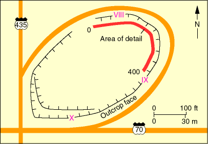
The Plattsburg Limestone study site is located in southwestern Wyandotte County, Kansas, on the northeastern access ramp of the interchange between I-435 and I-70 (figs. 2 and 7; stop 4 of Watney et al., 1989). GPR data were gathered at this site in order to image features associated with the Bonner Springs Shale (which caps the Wyandotte depositional sequence of Watney et al., 1989) and the Merriam Limestone Member of the Plattsburg Limestone (which forms the basal portion of the subjacent Plattsburg depositional sequence of Watney et al., 1989) (fig. 8). This site was chosen to determine the capabilities of GPR to image (1) hemi-channel forms within the sandstone lithology of the Bonner Springs Shale, (2) the erosional contact between the Merriam Limestone Member and Bonner Springs Shale, and (3) internal bedding geometries in the sandstone lithology of the Bonner Springs Shale and within the Merriam Limestone Member.
Fig. 7--Map of the Plattsburg Limestone study site (see fig. 2 for location). The locations of the measured sections shown in fig. 8 are indicated by the roman numerals VIII, IX, and X. The location of the photomosaic and GPR profile shown in figs. 9 and 10 is indicated by red line.
The Bonner Springs Shale outcrop at the study site consists of up to 8.7 m (28.5 ft) of channel sandstone overlain by 1.0 m (3.3 ft) of sandy shale, evidence of multiple episodes of erosional scouring and backfilling. The sandstone is extensively ripple cross-laminated, with a few festoon sets and local, climbing, ripple-drift cross lamination and herringbone crossbedding that is developed at the base (Enos et al., 1989). This sandstone, which apparently eroded the entire Bonner Springs Shale, is truncated by a distinct hemi-channel form (section X of fig. 8) filled with silty shale; silty, pebbly sandstone; and shale. The sand/shale hemi-channel form is truncated by another hemi-channel form expressed as abrupt westward thickening of the Merriam Limestone Member from 0.9 m in section IX to 4.0 m in section X of fig. 8.
Fig. 8--Measured stratigraphic sections and correlations of the Plattsburg Limestone (modified from Enos et al., 1989). The locations of measured sections VIII, IX, and X are shown on fig. 7.
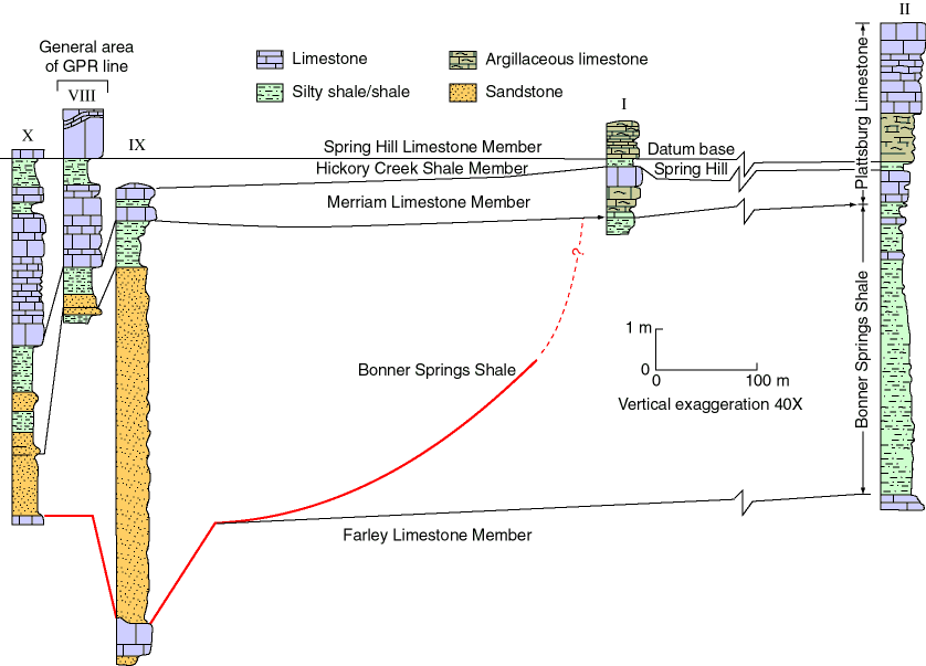
The Merriam Limestone Member is the flooding unit of the Plattsburg sequence (Watney et al., 1989). Lithologically, the basal part is typically a packstone, but it ranges from very argillaceous, nodular-weathering yellow limestone to ooid grainstone. The middle portion of the bed, below the most prominent shale break, is typically a skeletal packstone containing prominent, coated grains or oncoids (Enos et al., 1989). An overlying shale bed or parting can be traced over most of the area. The top unit is one or two beds of skeletal packstone. Argillaceous limestone caps are developed locally.
Prev Page--Captain Creek Limestone Member, cont. || Next Page--Plattsburg Limestone, cont.
Kansas Geological Survey
Web version September 15 1998
http://www.kgs.ku.edu/Current/1998/martinez/martinez6.html
Comments to webadmin@kgs.ku.edu