Kansas Geological Survey, Current Research in Earth Sciences, Bulletin 240, part 2
Prev Page--TTI Modeling for Localities in Central Kansas || Next Page--Summary and Conclusions
![]()
![]()
![]()
Kansas Geological Survey, Current Research in Earth Sciences, Bulletin 240, part 2
Prev Page--TTI Modeling for Localities in Central Kansas ||
Next Page--Summary and Conclusions
![]()
Most lower Paleozoic shelf limestones in Kansas, including the Viola Limestone, have a low organic content, hence the relatively organic-rich units that stratigraphically bracket the Viola Limestone (e.g., dark shales from the Middle Ordovician Simpson Group, the Upper Ordovician Maquoketa Shale, and the Devonian-Mississippian Chattanooga Shale) are used to interpolate its maturation. The most common analyses of thermal maturation using organic materials involve Rock-Eval pyrolysis and vitrinite reflectance. These analyses have been compiled for several wells in central Kansas and aid in evaluating the results of the TTI modeling.
Another source of data is homogenization temperatures (Th) of fluid inclusions in saddle (baroque) dolomites. Saddle dolomite is present in the Viola Limestone as a late-stage diagenetic phase filling vugs and molds. Th measurements were performed using a Fluid, Inc. adapted U.S.G.S. gas-flow heating/freezing stage attached to an optical microscope. Doubly polished thin sections used for the fluid-inclusion microscopy were made using cold techniques, in order to avoid thermal damage to the fluid inclusions.
Maturation of lower Paleozoic strata can be semi-quantitatively evaluated using Rock-Eval pyrolysis. Four basic parameters (S1, S2, S3, and Tmax) are obtained by this method (Espitalié et al., 1977). S1 (expressed as mg HC/g rock, or the equivalent measure of kg HC/metric ton rock) measures free or adsorbed hydrocarbons present in the rock. S2 (expressed as mg HC/g rock, or kg HC/metric ton rock) measures pyrolitic hydrocarbons derived from thermal breakdown of kerogen. The temperature at which maximum pyrolitic hydrocarbon yield occurs is Tmax. S3 (expressed as mg CO2/g rock, or kg CO2/metric ton rock) measures pyrolitic carbon dioxide yielded by the sample.
Ratios of these parameters can be used as approximate measures of maturation (Espitalié et al., 1977). S1/(S1 + S2) defines the transformation ratio (TR). TR increases with thermal maturation until expulsion of hydrocarbons take place. According to Tissot and Welte (1984) and Peters (1986), the oil window corresponds to a TR range between 0.1 to 0.4 (table 1). Tmax also increases with thermal maturation. The oil window according to Tmax lies between 435 and 470° C, with the caveat that Tmax values signaling the beginning of significant oil generation may vary according to the type of organic matter (Peters, 1986) (table 1). Tmax values for type I organic matter, which typifies some pre-Devonian rocks, commonly has a narrow range of variation between 435 and 450° C (Tissot et al., 1987).
Figures 6 and 7 show the Tmax and TR data collected for north-central Kansas, which apply to the area modeled in McPherson County. No data are available close to the locality modeled in Harper County. In spite of scatter, these results indicate that Ordovician strata in Kansas are immature or are in early stages of oil generation. Slightly higher maturity generally is registered by the TR data, but onset of oil generation is still indicated. The measured level of maturation can be accommodated by the results obtained by the TTI modeling. As higher geothermal gradients are assumed, lesser thicknesses of Cretaceous rocks have to be assumed in order to obtain a similar level of maturity. The model suggests that geothermal gradients greater than 25 to 30° C/km are not indicated because amount of Cretaceous strata would have to be unrealistically thin at the McPherson County locality (fig. 3).
Fig. 6--Thermal maturation of Middle and Upper Ordovician strata in north-central Kansas as expressed by Rock-Eval Tmax data. These data indicate Middle and Upper Ordovician strata in Kansas are immature to marginally mature with respect to petroleum generation. A listing of these samples is in Appendix II in Newell (1996). Letter by each well location denotes the source of the analyses: a = DGSI (Wallace Dow and Suhas Talukdar, personal communication,1986-1994), b = Sohio (Irene Penfield, personal communication, 1984-1985), c = U.S. Geological Survey (Joseph Hatch, personal communication, 1984-1985), d = Brown & Ruth (Susan Landon, personal communication,1984). Samples analyzed by DGSI were tested by procedures outlined in Jarvie (1991) for ascertaining total organic carbon (TOC). Pyrolysis data on these samples were obtained using a Rock-Eval II instrument (Philp and Galvez-Sinibaldi, 1991). Kerogen inspected by microscopy were prepared by techniques in Dow and O'Connor (1982). Instrumentation used by remaining sources is unknown. Core samples and cuttings for all analyses were hand-picked and washed with distilled water to remove impurities. Rock-Eval pyrolysis was performed on samples with TOC > 0.2 wt. %.
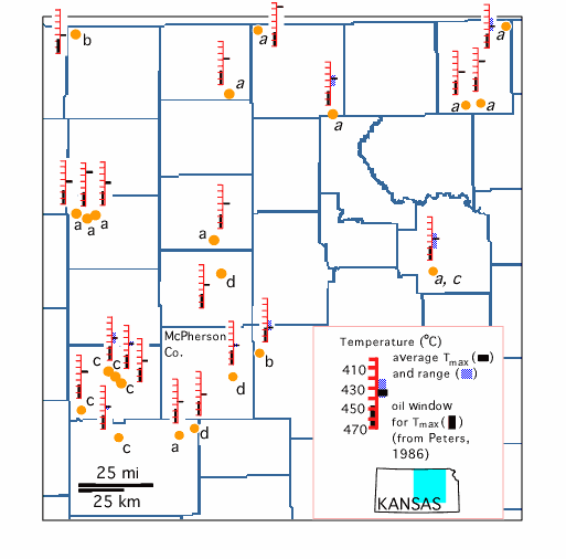
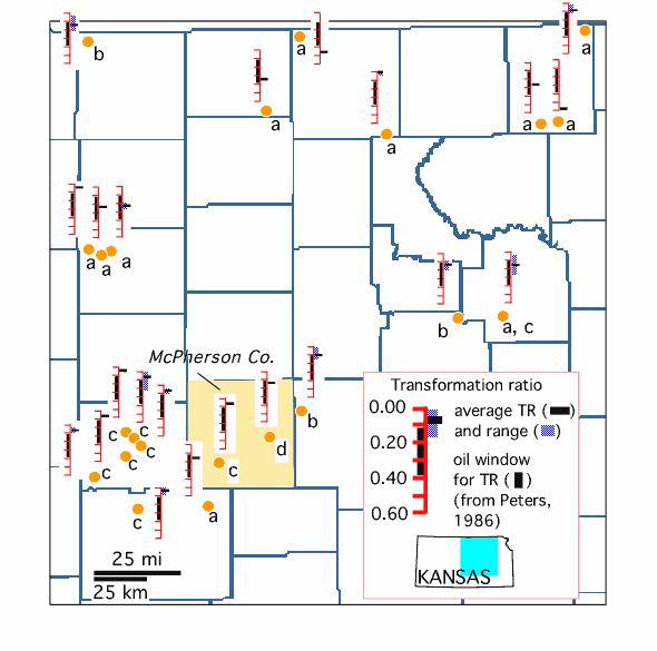
Fig. 7--Thermal maturation of Middle and Upper Ordovician strata in north-central Kansas as expressed by Rock-Eval transformation ratios (TR). A listing of these samples are in Appendix II in Newell (1996). Although slightly higher maturities are indicated by the TR data than with the Tmax data (fig. 6), immature to marginal maturity with respect to petroleum generation is still indicated. Letter by each well location denotes the source of the analyses: a = DGSI (Wallace Dow and Suhas Talukdar, personal communication,1986-1994), b = Sohio (Irene Penfield, personal communication, 1984-1985), c = U.S. Geological Survey (Joseph Hatch, personal communication, 1984-1985), d = Brown & Ruth (Susan Landon, personal communication,1984). Samples analyzed by DGSI were tested by procedures outlined in Jarvie (1991) for ascertaining total organic carbon (TOC). Pyrolysis data on these samples were obtained using a Rock-Eval II instrument (Philp and Galvez-Sinibaldi, 1991). Kerogen inspected by microscopy were prepared by techniques in Dow and O'Connor (1982). Instrumentation used by remaining sources is unknown.
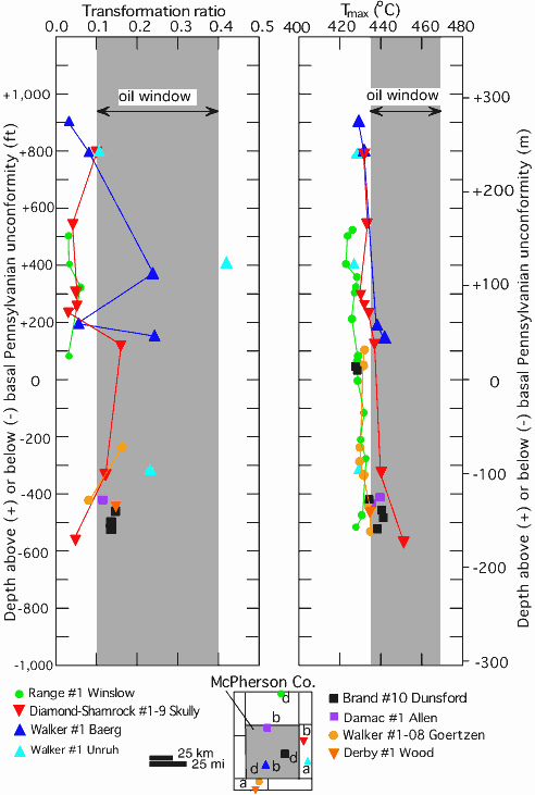
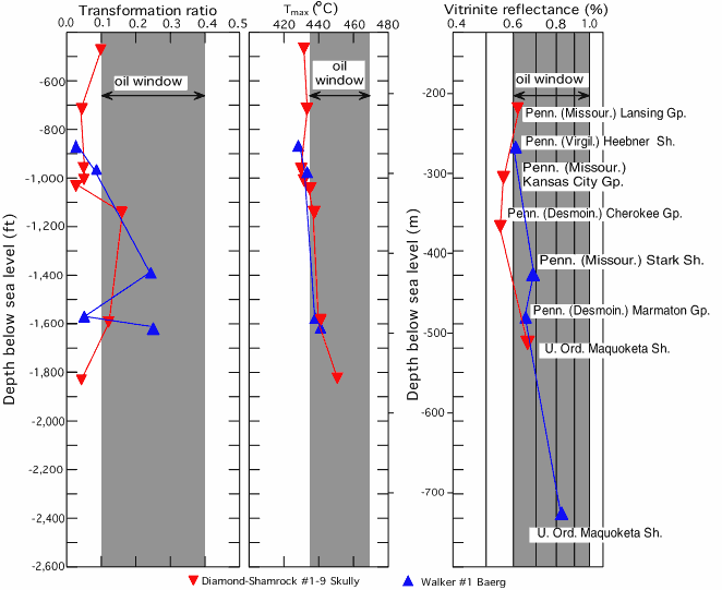
The wells in the vicinity of McPherson County show a slight increase in Tmax and TR with depth (fig. 8). Variations in levels of maturation are evident between wells, and with depth for each well. Even though the effects of depth and stratigraphy are largely removed by plotting the maturation profiles relative to the basal Pennsylvanian unconformity (Wojcik et al., 1994), differences in maturation between wells are still evident. Inasmuch as these wells largely have similar stratigraphy at the basal Pennsylvanian unconformity (i.e., nearly identical units are present both below and above this unconformity), the consistent difference in maturity at given stratigraphic levels is most likely due to a variation in thermal history experienced at each locality. For example, the Tmax values at the Diamond-Shamrock #1-9 Skully well indicate consistently greater maturation than those recorded at the nearby Walker #1 Unruh well. Thermal conductivities at both wells are similar due to their nearly identical stratigraphy; therefore, a locally higher heat flow or localized advective heat transport would be the most likely explanation for the greater maturation at the Diamond-Shamrock #1-9 Skully well.
Fig. 8--Rock-Eval maturation profiles based on Tmax and TR data for wells in the vicinity of McPherson County, Kansas, plotted by depth in relation to the basal Pennsylvanian unconformity. Lines connect analyses from selected wells. Some of the anomalously high TR values could be due the presence of migrated hydrocarbons, which would inordinately augment the S1 peak during pyrolysis (Clementz, 1979; Peters, 1986). Compositional variations in the kerogen and rock matrix also may be factors (Tissot et al., 1987). See text for discussion. Letter by each well location denotes the source of the analyses: a = DGSI (Wallace Dow and Suhas Talukdar, personal communication,1986-1994), b = Sohio (Irene Penfield, personal communication, 1984-1985), c = U.S. Geological Survey (Joseph Hatch, personal communication, 1984-1985), d = Brown & Ruth (Susan Landon, personal communication,1984). Samples analyzed by DGSI were tested by procedures outlined in Jarvie (1991) for ascertaining total organic carbon (TOC). Pyrolysis data on these samples were obtained using a Rock-Eval II instrument (Philp and Galvez-Sinibaldi, 1991). Kerogen inspected by microscopy were prepared by techniques in Dow and O'Connor (1982). Instrumentation used by remaining sources is unknown.
Vitrinite is an organic maceral derived from the tissue of terrestrial plants (Tissot and Welte, 1984). With increasing thermal maturity, vitrinite undergoes progressive, irreversible graphitization and consequently its reflectivity increases. Direct assessment of the thermal maturity of lower Paleozoic rocks by vitrinite reflectance is not feasible because terrestrial plants are not present in pre-Silurian rocks (Hunt, 1979). Vitrinite reflectance (Ro) is the most commonly used quantitative thermal maturation indicator in the oil industry and several scales correlating it to stages of oil generation have been established (cf., Héroux et al., 1979; Waples, 1980; Dow and O'Connor, 1982; van Gijzel, 1982; Tissot and Welte, 1984). In general, Ro values from 0.5 to 1.4% (±0.1%) correspond to the range of maturation in which oil is generated, with the peak of oil generation occurring about 1.0% Ro (fig. 9; also see table 1).
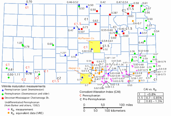
Fig. 9--Thermal maturation in Kansas as expressed by available published (Jenden et al., 1988; Barker et al., 1992) and unpublished maturation data (Appendices II and III in Newell, 1996). Conodont alteration index (CAI) is a coloration scale applied to the progressive darkening of conodonts with thermal maturation, and can be related to vitrinite reflectance by the conversion in the legend (from Harris, 1979). VRE (vitrinite-reflectance equivalent) data are from Barker et al. (1992), and is based on correlation of Tmax data with vitrinite-reflectance data from Pennsylvanian rocks in the Cherokee basin. McPherson and Harper counties are shaded.
The correlation of TTI to Ro values by Waples (1980, 1981) (table 1) has been amended by recent publications. For example, by a linear relationship between Ro values and TTI, Morrow and Issler (1993) equated 0.7% Ro to a TTI of 50; Waples (1980) equated it to a TTI of 10 to 20. According to these more recent findings, the models presented in this report would have to assume even higher geothermal gradients, deeper burials, or both, to account for the Ro measurements taken near the modeling localities. Numerical models of maturation, as well as the correlation of the calculations to directly observed maturation parameters, are beyond the scope of this paper. However, it is significant that even with the tendency of the Waples correlation to perhaps overestimate maturation in terms of vitrinite-reflectance equivalency, the calculated maturation generally is still less than the observed maturation.
Published and new Ro maturation data for Kansas show Pennsylvanian shales in the vicinity of McPherson County with Ro values of 0.5 to 0.7% (fig. 9). Maturation around Harper County is slightly greater, with Ro ranging from 0.6 to 0.8% in the Pennsylvanian section. According to TTI-to-Ro correlations from Waples (1980) (table 1), an Ro between 0.6 to 0.7% corresponds to a TTI from 10 to 20. If the high end of the Ro range is accepted for the base of the Pennsylvanian System for the locality modeled at McPherson County (i.e., 0.7% Ro, which corresponds to TTI = 20), and the thickness of Cretaceous rocks is kept at 1,500 ft (460 m), a geothermal gradient of approximately 40° C/km would be necessary to account for this maturation (fig. 4). However, this geothermal gradient is higher than the highest values for this area, which range between 25 and 35° C/km, based on local measurements (see figs. 1, 4), and therefore it may be necessary to invoke greater Cretaceous burial instead of increasing the geothermal gradient. The maximum likely Cretaceous thickness of 3,000 ft (915 m) would reduce the necessary geothermal gradient to 32° C/km, which is within the acceptable range of geothermal gradients as constrained by organic maturation in the Simpson Group (figs. 3, 4). A geothermal gradient of 32° C/km in conjunction with 3,000 ft (915 m) of Cretaceous burial would subject the Viola Limestone to a maximum burial temperature of 90° C at the end of Cretaceous time. Inasmuch as Cretaceous cover has to be maximized in the TTI model to account for observed maturation, there is a suggestion that the model, which assumes simple burial heating and constant heat flow, may be inadequate.
The greatest vitrinite reflectance (0.8% Ro) for Pennsylvanian strata nearest the locality modeled in Harper County corresponds to TTI = 25 (table 1). A geothermal gradient of 30° C/km at this locality will produce a calculated maturation of TTI = 25 at the base of the Pennsylvanian section; therefore, the lower part of the range of geothermal gradients observed in this region (i.e., 25 to 40° C/km; see fig. 1) can account for the observed maturation. A model assuming a geothermal gradient of 30° C/km predicts that the maximum burial temperature experienced by the Viola Limestone in Harper County was approximately 80° C in Permian time.
Vitrinite-reflectance depth profiles (fig. 10), like the Rock-Eval depth profiles in figure 8, contain scatter and show zones of apparently higher maturation sandwiched between strata with lower maturation. Different maturation at the same stratigraphic horizon between nearby wells (where similar types of organic matter and rock matrix would be expected), and at nearly similar depths (i.e., no great differences in burial history), indicates that the modeling assumptions of simple burial heating and constant heat flow may not be applicable to these rocks. These anomalous zones could be due to compositional variations in organic macerals (Price and Barker, 1985; Tissot et al., 1987) and rock matrix (Law and Nuccio, 1986), or they may even be due to nongeologic causes (Feazel and Aram, 1990). In any case, localized heating, possibly by lateral movement of warm fluids along thin stratigraphic intervals, should not be excluded.
Fig. 10--Rock-Eval and vitrinite maturation profiles for two wells near McPherson County, Kansas (refer to fig. 8 for locations). Reflectance values for Ordovician strata are on vitrinite-like material. See text for discussion.
Homogenization temperatures (Th) measurements can be compared to the maximum burial temperature modeled for the Viola Limestone. To do this, Th from saddle dolomites from three cores taken from the Viola Limestone (e.g., Damac #1 Sandra Allen in northern McPherson County, Derby #1 Wood in northern Reno County, and Midcontinent Marine #1 South Hilger in southern Reno County) was measured (fig. 1).
The saddle dolomites analyzed are present in vugs and molds and contain abundant fluid inclusions that are varyingly concentrated in zones parallel to crystal faces. Zones such as these are characteristics of growth bands of primary fluid inclusions (Goldstein and Reynolds, 1994). All inclusions observed are two-phase, with consistent liquid-to-vapor ratios, despite differences in sizes of the inclusions. For purposes of fluid-inclusion microscopy, fluid-inclusion assemblages were defined (Goldstein and Reynolds, 1994). In this study, fluid-inclusion assemblages are defined as a group of closely associated inclusions along a growth band. For all three samples, Th values overlap; the range of all measurements spans about 40° C, with maximum values of 135 to 140° C (fig. 11). According to Goldstein and Reynolds (1994), in an assemblage derived from a single thermal event, approximately 90% of the fluid inclusions should fall within a temperature interval of 10 to 15° C. Most fluid-inclusion assemblages in the samples studied have Th values within a 10 to 15° C temperature interval. A minimum estimate of the temperature experienced can be inferred as being the highest Th from a consistent fluid-inclusion assemblage (Goldstein and Reynolds, 1994). In the case of the Viola Limestone, this temperature is estimated to be 115 to 130° C for both the Midcontinent Marine #1 South Hilger well and the Derby #1 Wood well, and 115 to 120° C for the Damac #1 Allen well. Although higher Th measurements are recorded (fig. 11), they are either singular determinations or are from assemblages that have a broad temperature spread, making them less useful for estimating minimum temperature experienced by these rocks.
Fig. 11--Histograms of Th measurements, with fluid-inclusion assemblages noted, for samples of saddle dolomite from the Upper Ordovician Viola Formation from three cores in central Kansas (see fig. 1 for locations). Patterns indicate fluid-inclusions from a single assemblage; blank indicates a single determination within a fluid-inclusion assemblage. The Th values are well in excess of maximum burial temperatures inferred from TTI modeling. For a tabulation of this data, see Newell, 1996, table 8.7.
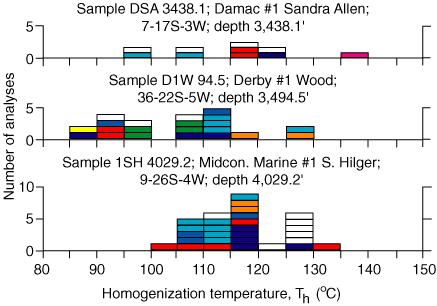
The Th values are not corrected for pressure and therefore represent minimum temperatures of entrapment (Roedder, 1984; Goldstein and Reynolds, 1994). Even so, they are approximately 15 to 50° C greater than maximum temperatures inferred for the Viola Limestone based on its burial history and current geothermal gradients. The maximum recorded Th of 139° C from a primary fluid inclusion at the Damac #1 Sandra Allen well (fig. 11) represents a temperature that is 49 to 69° C in excess of the maximum inferred burial temperature at the locality modeled in McPherson County (depending on what geothermal gradient is assumed). Even if the moderately "cool" temperature of 112° C (the average Th from the Damac #1 Sandra Allen core) is conservatively taken as the maximum temperature experienced at that locality when the Viola Limestone was at its inferred maximum depth of 4,500 ft (1,370 m) during Late Pennsylvanian to Early Permian time, the resulting geothermal gradient would have to have been 68° C/km. This geothermal gradient is approximately twice the present-day gradient and is well in excess of any gradient that can be reasonably modeled from simple burial heating (fig. 3). If higher geothermal gradients are used, then calculated maturation unreasonably exceeds direct organic maturation or Cretaceous cover would have to be compensatorially unreasonably thin.
The uppermost modal Th values will approximate a minimum estimate of how hot a mineral has been, either when it was precipitated, or particularly in the case of calcite, by subsequent reequilibration (Barker and Goldstein, 1990; Goldstein and Reynolds, 1994). The degree to which the highest modal Th value approaches the actual maximum temperature is largely unclear though, due to ambiguities associated with pressure corrections, timing of entrapment, and other physical and chemical conditions affecting the inclusion (Goldstein and Reynolds, 1994). The highest modal Th value of 125-130° C occurs in the Midcontinent Marine #1 South Hilger core, the most southerly and most deeply buried sample. However, the shallowest and most northerly sample from the Damac #1 Sandra Allen core does not record the lowest modal Th value of all the samples analyzed. Its modal Th of 115-120° C is 5° C greater than the modal Th of the Derby #1 Wood well. There is no apparent correspondence between burial depth and modal Th; therefore, a maturation model that invokes a linear increase in temperature with depth is probably not accurate to depict the burial and thermal history of the Viola Limestone. The temperatures recorded by the saddle dolomites probably represent one or more ephemeral thermal events: either one or more thermal pulses heating the entire stratigraphic column or advective fluid flow(s) out of the Ouachita foreland basin, as suggested by Leach and Rowan (1986).
Prev Page--TTI Modeling for Localities in Central Kansas || Next Page--Summary and Conclusions
Kansas Geological Survey
Web version March 16, 1998
http://www.kgs.ku.edu/Current/1997/newell/newell4.html
email:webadmin@kgs.ku.edu