Kansas Geological Survey, Current Research in Earth Sciences, Bulletin 240, part 2
Prev Page--Introduction || Next Page--Direct Maturation Indicators
![]()
![]()
![]()
Kansas Geological Survey, Current Research in Earth Sciences, Bulletin 240, part 2
Prev Page--Introduction ||
Next Page--Direct Maturation Indicators
![]()
A time-temperature index model (Waples, 1980; 1981), based on work by Lopatin (1971), takes into account both time and temperature in calculating a cumulative thermal maturity for sedimentary organic matter. This technique assumes that the rates of chemical reactions involved in the conversion of kerogen to petroleum can be mathematically approximated by a first-order chemical reaction in which the rate of maturation doubles for every 10° C rise in temperature. The Lopatin technique generates a dimensionless number, called the "time-temperature index" (TTI) that Waples (1981) empirically correlated to vitrinite reflectivity and stages of oil and gas generation (table 1). The TTI models were run with a geothermal gradient that did not vary over geologic time, but with a surface temperature that changed according to paleoclimate and global position of Kansas over geologic time. The tectonic history was depicted by plotting subsidence and uplift of various strata against time. Subsidence was determined by thicknesses and ages of strata; uplift was determined by estimating erosion that occurred at major unconformities. The graphical history of subsidence and uplift and of subsurface temperatures was also utilized to infer the maximum temperature and depth a given stratigraphic interval experienced and the time at which various levels of maturation were achieved. Refinements can be added to the TTI calculation, such as decompacting the sedimentary column and taking into account heat flow and thermal conductivity of individual rock layers to determine the geothermal gradient. In this study, however, only limited organic and thermal maturation data were available with which to compare the results of such elaborate modeling, so the models presented were kept simple.
Table 1--Correlation of time-temperature index (TTI), Rock-Eval transformation ratio (TR), and Rock-Eval Tmax to vitrinite reflectance (Ro). TTI to Ro is from Waples (1981); TR and Tmax to Ro is from Peters (1986).
| Stage | TTI | TR | Tmax (°C) | Ro(%) |
|---|---|---|---|---|
| Onset of oil generation (Peters) | ~0.1 | ~435-445 | ~0.6 | |
| Onset of oil generation (Waples) | 15 | 0.6 | ||
| Peak oil generation (Waples) | 75 | 1.1 | ||
| End oil generation (Waples) | 160 | 1.3 | ||
| End oil generation (Peters) | ~0.4 | ~470 | ~1.4 | |
| Upper TTI limit for wet gas (Waples) | 1,500 | ~3.8 |
TTI calculations are specific only to a single locality--usually one well. In this study, two localities were selected: a location at the crest of the Central Kansas arch in western McPherson County (T. 19 S., R. 4 W.), and a location in southern Harper County (T. 33 S., R. 7 W.) where the Viola Limestone is deepest in central Kansas (fig. 1). The localities were selected to provide answers to the following questions:
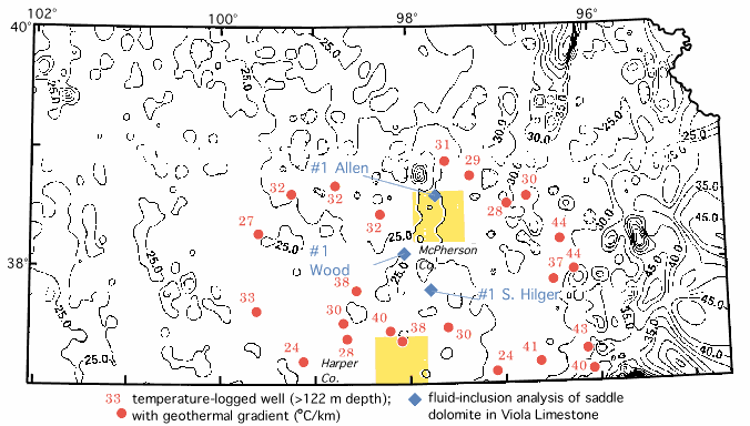
Fig. 1--A geothermal gradient map of Kansas based on 43,348 bottom-hole temperatures (BHT's) from oil and gas tests (Stavnes and Steeples, 1982). Counties targeted for TTI modeling are shaded; wells in which saddle dolomites were analyzed for fluid-inclusion homogenization temperatures are superimposed on the geothermal gradient map. Temperature-logged wells (Stavnes, 1982) in the vicinity of the modeling localities are also shown, along with their determined geothermal gradients. Isopleths are at 5° C/km. Generally higher geothermal gradients in eastern Kansas are attributable to data derived from many relatively shallow wells that were drilled only into Pennsylvanian strata. Because strata are characterized by relatively low thermal conductivity, temperatures rise relatively rapidly with depth; consequently, a BHT measurement from a shallow well in this locality generally will yield an anomalously higher geothermal gradient (Förster and Merriam, 1993).
Although geothermal gradient is important for TTI calculations, it is a hard-to-determine parameter because temperature data, principally derived from oil wells after drilling, generally are not measured with precision. To compensate for this imprecision, several TTI models were calculated with a range of likely geothermal gradients. Cretaceous burial was determined to be a second parameter for which there is poor control, and TTI models were also run with varying thicknesses of Cretaceous strata. Other input parameters for the two localities modeled are discussed below.
Maps based on bottom-hole temperature (BHT) measured during wireline logging (e.g., Stavnes, 1982; Stavnes and Steeples, 1982; American Association of Petroleum Geologists, 1976) indicate the geothermal gradient in McPherson County (the northern part of the study area) is approximately 25° C/km, but nearby wells that have been thermally logged (Stavnes, 1982) indicate a gradient of approximately 30° C/km (fig. 1). The geothermal gradient in Harper County (the southern part of the study area) is approximately 25° C/km according to BHT data, but nearby wells at thermal equilibrium with surrounding rock have recorded gradients as high as 40° C/km (Stavnes, 1982) (fig. 1). The difference in geothermal gradient is caused by several factors, including inadequate time for thermal equilibration of the well bore with the surrounding rock and differences in thermal conductivity of the strata being logged (Deming et al., 1990; Förster and Merriam, 1993; Förster et al., 1993).
Average surface temperatures used in the TTI modeling are presented in table 2. Stratigraphic data for McPherson and Harper counties are presented in tables 3 and 4, respectively. Uncertainties in the history of subsidence and uplift stem from the numerous unconformities that are characteristically present on the craton. Phanerozoic time in the midcontinent is dominated by erosion and nondeposition; 50 to 85% of this time is represented by unconformities (Merriam, 1963). Although the geologic record is incomplete, lower Paleozoic units (i.e., Arbuckle, Simpson, Viola, Maquoketa, "Hunton," Chattanooga, and Mississippian strata) are characterized by only mild deformation, with relative dips between units varying less than 5 degrees (Lee, 1956). The thinness of these units compared to their lateral extent also suggests that significant subsidence and uplift were not the norm during the early Paleozoic and that the maximum preserved thickness of individual units is probably close to their original compacted thickness, despite unconformities usually present at the tops of these units. Furthermore, because little maturation occurs at such shallow depths, gaps in sedimentation in the lower Paleozoic section are relatively inconsequential for purposes of TTI calculations.
Table 2--Change of mean surface temperature with time in McPherson and Harper counties (from Habicht, 1979). Surface temperature is assumed to change in a linear fashion between the temperature nodes and times. Times are given in million years before the present (Ma).
| Age | Mean Surface Temperature (° C) |
|---|---|
| Present (0 Ma) | 12 |
| Late Tertiary (5 Ma) | 14 |
| Early Tertiary (40 Ma) | 18 |
| Cretaceous (103 Ma) | 20 |
| Jurassic (175 Ma) | 24 |
| Triassic (230 Ma) | 29 |
| Permian (270 Ma) | 30 |
| Carboniferous (325 Ma) | 24 |
| Devonian (385 Ma) | 26 |
| Silurian (425 Ma) | 27 |
| Ordovician (470 Ma) | 20 |
| Cambrian (545 Ma) | 26 |
Table 3--Subsidence and uplift of basement in McPherson County. Duration of tectonic movement is given in Ma (absolute ages derived from Haq and Van Eysinga, 1987); formation names or age subdivisions, for reference, are in parentheses.
| Age (and unit) | Ma | Subsidence | Uplift |
|---|---|---|---|
| Cambrian-Ordovician (Arbuckle) | 524-478 | 550 ft (168 m) | --- |
| 478-466 | --- | 50 ft (15 m) | |
| Ordovician (Simpson, Viola) | 466-446 | 200 ft (61 m) | --- |
| Ordovician (Maquoketa) | 446-440 | 50 ft (15 m) | --- |
| Silurian ("Hunton") | 440-422 | 250 ft (76 m) | --- |
| 422-388 | --- | --- | |
| Devonian ("Hunton") | 388-376 | 50 ft (15 m) | --- |
| 376-368 | --- | 300 ft (91 m) | |
| Devonian-Mississippian (Chattanooga) | 368-340 | 350 ft (100 m) | --- |
| Mississippian strata | 340-326 | 325 ft (99 m) | --- |
| 326-310 | --- | 100 ft (30 m) | |
| Pennsylvanian strata (Desmoinesian) | 310-306 | 300 ft (91 m) | --- |
| Pennsylvanian strata (Missourian) | 306-302 | 325 ft (99 m) | --- |
| Pennsylvanian strata (Virgilian) | 302-290 | 1,000 ft (305 m) | --- |
| Permian strata | 290-250 | 2,250 ft (686 m) | --- |
| 250-140 | --- | 550 ft (168 m) | |
| Cretaceous strata1 | 140-68 | 1,500 ft (457 m)1 | --- |
| 68-0 | --- | 1,950 ft (594 m) |
1Cretaceous thickness variable, but all of Cretaceous strata, plus 450 ft (137 m) of underlying Permian strata, was modeled as eroded from 68-0 Ma.
Table 4--Subsidence and uplift of basement in Harper County. Duration of tectonic movement is given in Ma (absolute ages derived from Haq and Van Eysinga, 1987); formation names or age subdivisions, for reference, are in parentheses.
| Age (and unit) | Ma | Subsidence | Uplift |
|---|---|---|---|
| Cambrian-Ordovician (Arbuckle) | 524-478 | 1,050 ft (320 m) | --- |
| 478-466 | --- | 50 ft (15 m) | |
| Ordovician (Simpson, Viola) | 466-446 | 150 ft (46 m) | --- |
| Ordovician (Maquoketa) | 446-440 | --- | --- |
| Silurian ("Hunton") | 440-422 | --- | --- |
| 422-388 | --- | --- | |
| Devonian ("Hunton") | 388-376 | --- | --- |
| 376-368 | --- | 50 ft (15 m) | |
| Devonian-Mississippian (Chattanooga) | 368-340 | 125 ft (38 ft) | --- |
| Mississippian strata | 340-326 | 325 ft (99 m) | --- |
| 326-324 | --- | 100 ft (30 m) | |
| Pennsylvanian strata (Morrowan-Atokan) | 324-310 | 325 ft (99 m) | --- |
| Pennsylvanian strata (Desmoinesian-Virgilian) | 310-290 | 1,775 ft (541 m) | --- |
| Permian strata | 290-250 | 2,875 ft (876 m) | --- |
| 250-140 | --- | 175 ft (53 m) | |
| Cretaceous strata | 140-68 | 500 ft (152 m) | --- |
| 68-0 | --- | 600 ft (183 m) |
The lower Paleozoic units were buried relatively deeply by the end of Paleozoic time; therefore, the burial history after Paleozoic time is important. Unfortunately, much of this history has been erased by subsequent erosion. Cretaceous rocks are the thickest of the Mesozoic rocks in Kansas (Merriam, 1963), but the original thickness of these strata in central Kansas is difficult to estimate due to erosion. Cretaceous rocks in northwestern Kansas reach 3,000 ft (920 m) in thickness but are completely eroded in the eastern part of the state (Merriam, 1963). Graphical projection of Cretaceous thicknesses to the McPherson County locality from regional cross sections (Merriam, 1963) indicate Cretaceous strata deposited there were at least 1,500 ft (460 m) but probably did not exceed 3,000 ft (920 m). The thickness of Cretaceous strata deposited in Harper County was presumably less than in McPherson County because this area was on the flank of the Ozark dome, which was a geographical feature during Mesozoic time (Merriam, 1963). The thickness of Cretaceous strata at the Harper County locality is estimated to be 500 ft (150 m). Erosion of Cretaceous strata presumably began at the beginning of the Laramide orogeny in Late Cretaceous to Early Tertiary time, and this erosion is assumed to have been continuous up to the present. Strata deposited during the Cenozoic in Kansas is relatively thin and thus inconsequential for purposes of TTI modeling.
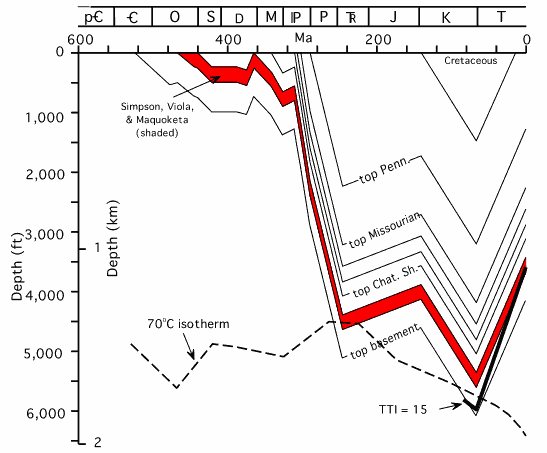
A tectonic mobility diagram and temperature history for McPherson County (fig. 2) shows the Viola Limestone reaching a maximum burial temperature of 70°C at the end of the Permian. This particular model illustrates a 30°C/km constant geothermal gradient and 1,500 ft (460 m) of Cretaceous strata. With this model, the beginning of significant oil generation (TTI = 15) would have started in the Simpson Group (directly beneath the Viola Limestone), in Late Cenozoic time (fig. 2). The Viola Limestone, like the Simpson Group, would therefore be marginally mature with respect to oil generation. A high-end estimate of 3,000 ft (920 m) of Cretaceous strata, in conjunction with a 30°C/km would have subjected the Viola Limestone to a maximum burial temperature of 85°C at the end of the Cretaceous; a 40°C/km gradient would produce a maximum burial temperature of 105°C at the end of the Cretaceous.
Fig. 2--A tectonic mobility diagram and temperature history for the area in McPherson County. This particular model illustrates a 30°C/km constant geothermal gradient and 1,500 ft (460 m) of Cretaceous strata. The Viola Limestone would attain a maximum burial temperature of 70°C at the end of the Permian according to this thermal and subsidence history. The start of significant oil generation, represented by TTI = 15, is shown rising through the stratigraphic section with time, reaching the base of the Simpson Group at about the mid-Tertiary.
The results of several TTI models for McPherson County with different geothermal gradients and Cretaceous cover are expressed in two nomograms that show the TTI calculated for the top of the Simpson Group, the base of Viola Limestone (fig. 3), and the base of the Pennsylvanian section (fig. 4). Most combinations of likely geothermal gradients and Cretaceous thicknesses at this location will put the Simpson Group into the oil window, but below the peak of oil generation (i.e., 15 < TTI < 75), whereas the Pennsylvanian section would be in the initial stages of oil generation (fig. 4).
Fig. 3--A nomogram expressing the results of TTI modeling at McPherson County as a consequence of geothermal gradient and depth of Cretaceous burial for the top of the Simpson Group (i.e., base of Viola Limestone). To read the TTI, extend a geothermal gradient from the base of the diagram in a vertical line to the assumed thickness of Cretaceous rocks (shown by diagonal lines). The resultant TTI is determined by extending a horizontal line left from the point at which the lines depicting the geothermal gradient and Cretaceous cover intersect. The ranges of geologically likely geothermal gradients and Cretaceous cover are shaded in yellow and blue, respectively. Most likely combinations of these (where the yellow and blue overlap) puts the Simpson Group and Viola Limestone into initial stages of oil generation.
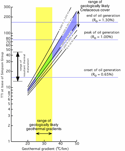
Fig. 4--A nomogram expressing the results of TTI modeling at McPherson County as a consequence of geothermal gradient and Cretaceous burial for the base of the Pennsylvanian section. See figure 3 for instructions for obtaining TTI. Most likely combinations of geothermal gradients and Cretaceous cover indicate the base of the Pennsylvanian section would be immature to only marginally mature with respect to oil generation.

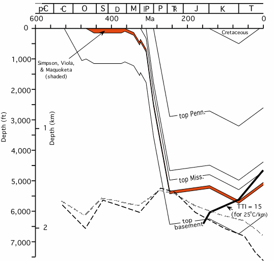
Because less Cretaceous cover is expected at the Harper County location, the calculated maturation in that area is principally dependent on geothermal gradient. The extremes in the geothermal gradient, as estimated with BHT's and the temperature-logged wells are 25°C/km and 40°C/km, respectively (fig. 1). With a geothermal gradient of 25°C/km, the Viola Limestone would experience a maximum temperature of 70°C at the end of the Permian (fig. 5). With a geothermal gradient of 40°C/km, the Viola Limestone would reach a maximum temperature of 95°C at the end of the Permian (fig. 5).
Fig. 5. A tectonic mobility diagram and temperature history for the area in Harper County. This particular model illustrates maturation associated with a 25°C/km constant geothermal gradient. The Viola Limestone would attain a maximum burial temperature of 70°C at the end of the Permian according to this thermal and subsidence history, as shown in the superimposed isotherm (heavy dashed line). Also superimposed on this diagram is a 90°C isotherm (light dashed line), which is the maximum burial temperature the Viola Limestone would experience if a 40°C/km constant geothermal gradient were assumed. The start of significant oil generation, represented by TTI = 15, is shown rising through the stratigraphic section with time, reaching the base of the Simpson Group at about the end of the Cretaceous.
Prev Page--Introduction || Next Page--Direct Maturation Indicators
Kansas Geological Survey
Web version March 16, 1998
http://www.kgs.ku.edu/Current/1997/newell/newell3.html
email:webadmin@kgs.ku.edu