Kansas Geological Survey, Current Research in Earth Sciences, Bulletin 240, part 1
Prev Page--Geologic Setting || Next Page--Methodology of Heat-Flow Determination
![]()
![]()
![]()
Kansas Geological Survey, Current Research in Earth Sciences, Bulletin 240, part 1
Prev Page--Geologic Setting || Next Page--Methodology of Heat-Flow Determination
![]()
The Dakota aquifer underlies most of the western one-half of Kansas and nearly all of eastern Colorado and most of Nebraska. It can be divided into a lower aquifer, comprising stratigraphically the Lower Cretaceous Cheyenne Sandstone and the Longford Member of the Kiowa Formation, and an upper aquifer comprising the Upper Cretaceous Dakota Formation. These upper and lower aquifer units are separated by the Kiowa aquitard, composed of marine black shale (fig. 2). Upper Cretaceous rocks (aquitard of mostly shale) confine the aquifer system. Because of the limited depths of the boreholes that are available for the study, the geothermal investigations mostly are focused on the interval of the upper Dakota aquifer (Dakota Formation) and the overlying Upper Cretaceous aquitard.
Data on fluid movement in the Dakota aquifer was compiled from studies by Belitz and Bredehoft (1988), Helgesen et al. (1984), Macfarlane (1995), Pruit (1978), and Whittemore et al. (1993). Figure 3 shows the direction of fluid movement in the Dakota. The regional, steady-state ground-water flow in the Denver Basin and adjacent Midcontinent is characterized by subnormal fluid pressure and subnormal fluid potential according to the simulated and observed potentiometric surfaces shown by Belitz and Bredehoeft (1988). The largest differences between land surface and potentiometric surface occur in the Nebraska Panhandle and the extreme northwestern part of Kansas. With an input of ground-water flow rates of 1 m/year in heat-flow models as calculated for the Dakota in the Panhandle (Gosnold et al., 1981), there is a good agreement with the heat-flow data ranging between 80 and 100 mW/m2.
Fig. 3. Map of structure on top of Dakota Formation in Kansas, Nebraska, eastern Colorado, and southwestern Wyoming showing general direction of fluid movement in Dakota aquifer (structure from Merriam, 1958; fluid movement from Helgesen et al., 1984; Pruit, 1978; Whittemore et al., 1993; McGovern and Wolf, 1993). Major structural features noted; outcrop of Dakota shown; CI = 500 ft (152 m).
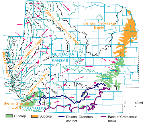
In the Kansas part of the Dakota aquifer, the main pattern of ground-water flow is from the topographically high recharge areas in southeastern Colorado (Sierra Grande region) and southwestern Kansas to discharge areas in the river valleys of central and north-central Kansas (Macfarlane, 1995. Additional recharge is from the overlying Ogallala Formation and alluvial valley aquifers in southwestern Kansas, and from the underlying Permian aquifer where these aquifers are connected hydraulically in the central part of the state (Macfarlane et al., 1992). The average linear velocities in the confined portion of the aquifer are determined to be about 1 to 75 ft/year (0.3 to 23.4 m/year) (P. A. Macfarlane, personal communication, 1994). Because of the lack of thermal data for the eastern flank of the Denver Basin, it is unknown how far the heat-flow anomaly outlined for the basin area (Blackwell and Steele, 1992) extends into eastern Colorado and western Kansas and to what extent eastward flow of fluids could affect the geothermal conditions there.
Prev Page--Geologic Setting || Next Page--Methodology of Heat-Flow Determination
Kansas Geological Survey
Web version March 14, 1998
http://www.kgs.ku.edu/Current/1997/forster/forster4.html
email:webadmin@kgs.ku.edu