Kansas Geological Survey, Current Research in Earth Sciences, Bulletin 240, part 1
Prev Page--Introduction || Next Page--Hydrology
![]()
![]()
![]()
Kansas Geological Survey, Current Research in Earth Sciences, Bulletin 240, part 1
Prev Page--Introduction || Next Page--Hydrology
![]()
The structure of the High Plains in western Kansas is relatively simple and straightforward. Cretaceous units overlie older Mesozoic and Paleozoic units and, in turn, are unconformably overlain by a veneer of Tertiary (Ogallala Formation) and Quaternary unconsolidated deposits (fig. 1). The sedimentary units, which rest on a crystalline basement of Precambrian age, range in thickness from about 1,100 m (3,500 ft) in the east to about 2,000 m (6,500 ft) in the west.
Fig. 1. Northwest-southeast cross section of Cretaceous units in western Kansas. Cross section shows general relations of units to each other (generally conformable) and to the unconformable underlying Jurassic Morrison Formation and Permian red beds and the unconformable overlying Tertiary Ogallala Formation. Datum = sea level. Index map shows location of cross section. Boreholes are numbered as follows: (1) Guy F. Atkinson No. 1 Beaumeister, SE SE NE sec. 31, T. 2 S., R. 39 W., Cheyenne County; (2) Miami No. 1 Stewart, NW NW NW sec. 7, T. 7 S., R. 33 W.,Thomas County; (3) Prime No. 1 Fallow, SE SE NE sec. 19, T. 10 S., R. 27 W., Sheridan County; (4) Phillips No. 1 Folkers, SW SW SW sec. 31, T. 13 S., R. 23 W., Trego County; (5) Mackall No. 1 Herrman, NE SE NE sec. 2, T. 16 S., R. 18 W., Rush County; (6) Prairie No. 1 Rude, SW SW SW sec. 11, T. 16 S., R. 13 W., Barton County; (7) Empire No. 1 Kroesch, NW SE sec. 33, T. 17 S., R. 9 W., Ellsworth County; (8) Ladow et al. No. 1 King, NW NE sec. 20, T. 19 S., R. 5 W., McPherson County; (9) Dickey No. 1 Reusser, SE SE SE sec. 26, T. 21 S., R. 2 W., McPherson County.
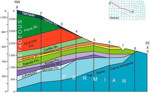
The Cretaceous covers much of the western one-half of Kansas. The configuration of these units reflects a different structural development from that expressed in the older Paleozoic units. The Hugoton Embayment, the major structural feature in western Kansas, was no longer active, and the structural pattern changed in the Mesozoic with the rise of the Rocky Mountains to the west. Major structural features recognizable in the Cretaceous are the Sierra Grande Uplift in southeastern Colorado, extending northeastward into western Kansas, and the Cambridge Arch, a southeast-northwest-trending positive feature extending southeastward into Kansas from Nebraska. In general, the Cretaceous units, other than where affected by these major structural features, dip uniformly and gently to the north and northwest as part of the southeastern flank of the Denver-Julesberg Basin, located farther west in Colorado. The units unconformably overlie either the Jurassic Morrison Formation, where present, or Permian red beds. The units are beveled from outcrop to about 915 m (3,000 ft) in thickness in the northwestern corner of Kansas in Cheyenne County.
In this study the thermal state of the stratigraphic units from the Kiowa Formation to Pierre Shale was investigated. The dominant lithology of the geologic units is given in figure 2 (see Merriam, 1957, 1963; Zeller, 1968 for details).
Fig. 2. Generalized stratigraphic column of Cretaceous units in Kansas showing age, stratigraphic unit, dominant lithology, and hydro-stratigraphy (adapted from Moore et al., 1952; Merriam, 1963).
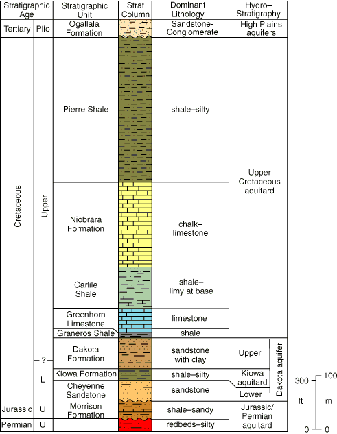
The Kiowa Formation (Kk) is predominantly a medium- to dark-gray, micaceous, silty, carbonaceous, soft to hard marine shale. Also included are minor amounts of limestone ("Champion shell bed"), quartzose sandstone, and bentonite. The shale becomes more silty and sandy east and southeast toward the old shoreline.
The Dakota Formation (Kd) contains lenticular sandstones composed of light-gray or light-brown, crossbedded, fine- to medium-grained, subrounded quartz fragments. The unit also contains considerable noncalcareous, micaceous, clayey or silty shale with interbedded siltstone.
The Graneros Shale (Kg) is a medium-gray to black, noncalcareous or slightly calcareous, silty, marine shale. It contains thin streaks of bentonite.
The Greenhorn Limestone (Kgh) consists mostly of limestone and chalky shale. The limestone is gray to light brown, chalky or crystalline, and very fossiliferous. The shale is gray to brownish, calcareous, and fossiliferous.
The lower part of the Carlile Shale (Kc) is a very fossiliferous, chalky shale containing stringers of limestone and thin seams of bentonite. The middle part is a gray to blue-gray, fossiliferous, clayey, noncalcareous shale. The upper part, the Codell Member, is a thin, silty sandstone.
The lower part of the Niobrara Formation (Kn) (Fort Hays Limestone Member) is a massive, chalk or chalky limestone separated by thin beds of chalky shale. The upper part (Smoky Hill Chalk) is a chalky shale with massive chalk beds and many bentonite beds.
The Pierre Shale (Kp) is predominantly shale, which is light to dark gray, soft, slightly calcareous, micaceous, fissile, and fossiliferous. Many bentonite beds are present as well as many concretionary zones. The lower part (Sharon Springs Member) is a dark-gray to black, micaceous, clayey shale.
Prev Page--Introduction || Next Page--Hydrology
Kansas Geological Survey
Web version March 14, 1998
http://www.kgs.ku.edu/Current/1997/forster/forster3.html
email:webadmin@kgs.ku.edu