Pottawatomie County General Stratigraphy
The stratigraphic units present in Pottawatomie County range from the late Pennsylvanian System to the early Permian System, and include the Wabaunsee, the Admire, the Council Grove, and the Chase.
The topography throughout much of Pottawatomie County is the result of past glacial activity. Glacial-related surface deposits include glacial till, outwash, and glaciolacustrine sediments. Glacial erratics ranging in size from marbles to cars dot the landscape. The dark yellow region in the south-central Pottawatomie County, covering 40 square miles and bounded by Louisville, Wamego, and St. George, is almost entirely glacial outwash deposits of well-sorted silt and fine- to medium-grained sands up to 100 ft thick.
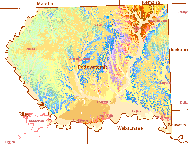
In Pottawatomie County, there are 34 distinct limestone members, the highest bedrock unit exposed being the Towanda Limestone Member (Middle Doyle Shale Formation) in the northwest corner around Olsburg, and the lowest ledge the Rulo Limestone Member (Middle Scranton Shale Formation) which crops out in the northeast area around Onaga. In addition, many shale units contain unnamed limestone ledges.
Source: KGS Bulletin 189, "Stratigraphic Succession in Kansas," Plate 1. Highest stratigraphic point in Pottawatomie County is Towanda Limestone Member. Lowest stratigraphic point in Pottawatomie County is the Cedar Vale Shale Member.
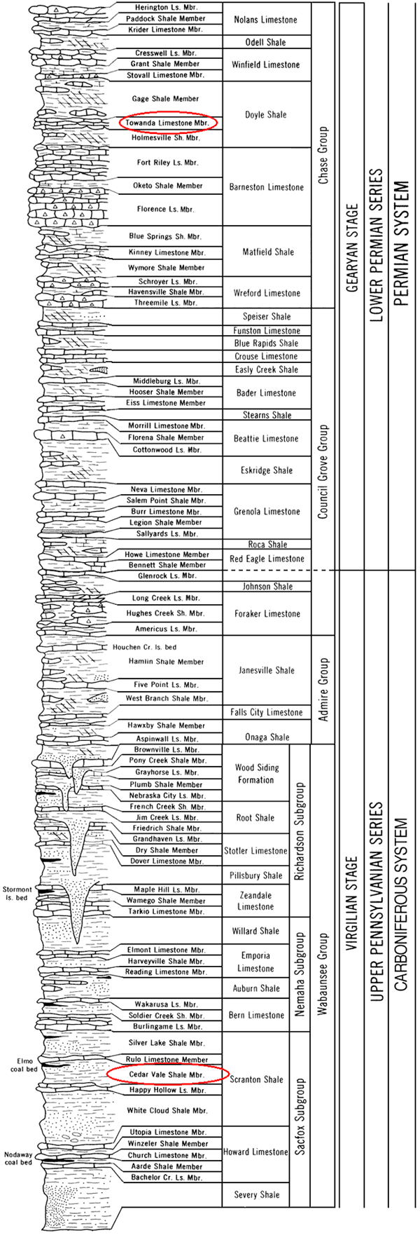
The following data table indicates the range of thicknesses of units present in Pottawatomie County, going from upsection to downsection (e.g., the Towanda Limestone Member overlies the Holmesville Shale Member, etc.) From Zeller, 1968.
| Formation | Member | Thickness (ft) |
|---|---|---|
| Doyle Sh | Towanda Ls | 5-15 |
| Holmesville Sh | 70 | |
| Barneston Ls | Fort Riley Ls | 30-45 |
| Oketo Sh | 0-8 | |
| Florence Ls | 12-30 | |
| Matfield Sh | Blue Springs Sh | 15-35 |
| Kinney Ls | 1-24 | |
| Wymore Sh | 9-25 | |
| Wreford Ls | Schroyer Ls | 6-13 |
| Havensville Sh | 1.5-27 | |
| Threemile Ls | 6-33 | |
| Crouse Ls | Speiser Sh | 18-35 |
| Funston Ls | 5-28 | |
| Blue Rapids Sh | 15-30 | |
| Easly Creek Sh | NA | 10-20 |
| Bader Ls | Middleburg Ls | 1.5-8 |
| Hooser Sh | 3-11 | |
| Eiss Ls | 7-18 | |
| Sterns Sh | NA | 5-20 |
| Beattie Ls | Morrill Ls | 2-9 |
| Florena Sh | 3-18 | |
| Cottonwood Ls | 6 | |
| Eskridge Sh | NA | 20-41 |
| Grenola Ls | Neva Ls | 9-28 |
| Salem Point Sh | 4-15 | |
| Burr Ls | 1-15 | |
| Legion Sh | 1.4-13 | |
| Sallyards Ls | 0.3-5 | |
| Roca Sh | NA | 7-34 |
| Red Eagle Ls | Howe Ls | 1-6 |
| Bennett Sh | 4-27 | |
| Glenrock Ls | 0-3 | |
| Johnson Sh | NA | 13-26 |
| Foraker Ls | Long Creek Ls | 2.5-12 |
| Hughes Creek Sh | 20-56 | |
| Americus Ls | 1.5-20 | |
| Janesville Sh | Hamlin Sh | 34-52 |
| Five Point Ls | 1-13 | |
| West Branch Sh | 20-43 | |
| Falls City Ls | NA | 6-17 |
| Onaga Sh | Hawxby Sh | 4-19 |
| Aspinwall Ls | 1-15 | |
| Towle Sh | 2-15 | |
| Wood Siding | Brownville Ls | 1-5 |
| Pony Creek Sh | 5-50 | |
| Grayhorse Ls | 0.5-6 | |
| Plumb Sh | 10-30 | |
| Nebraska Ls | 1-5 | |
| Root Sh | French Creek Sh | 20-45 |
| Jim Creek Ls | 0.3-2 | |
| Friedrich Sh | 5-40 | |
| Stotler Ls | Grandhaven Ls | 2-10 |
| Dry Sh | 0-26 | |
| Dover Ls | 1-5 | |
| Pillsbury Sh | NA | 1-50 |
| Zeandale Ls | Maple Hill Ls | 1-5 |
| Wamego Sh | 4-25 | |
| Tarkio Ls | 0-10 | |
| Willard Sh | NA | 30-65 |
| Emporia Sh | Elmont Ls | 1-15 |
| Harveyville Sh | 1-25 | |
| Reading Ls | 1.5-15 | |
| Auburn Sh | NA | 20-70 |
| Bern Ls | Wakarusa Ls | 2-18 |
| Soldier Creek Sh | 1-25 | |
| Burlingame Ls | 2-16 | |
| Scranton Sh | Silver Lake Sh | 4-45 |
| Rulo Ls | 0-4 | |
| Cedar Vale Sh | 16-60 |
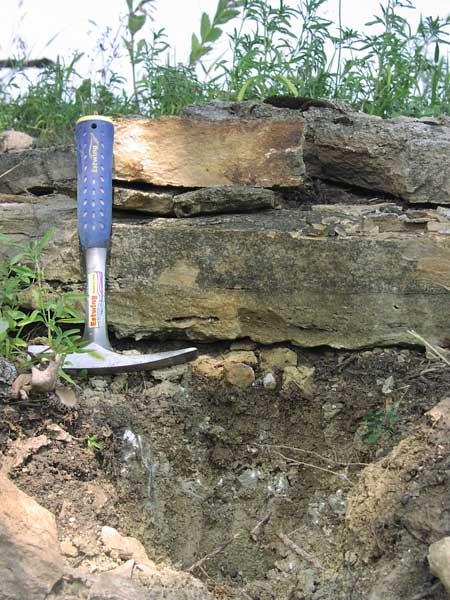
The following photographs and descriptions chronicle in greater detail the characteristics of major limestone units in Pottawatomie County. Some of the described units have been or continue to be of commercial interest.
Towanda Limestone Member
(NW corner of Booth Creek Rd and Case Ravine Rd)
The Towanda Limestone, generally 15 ft thick in Pottawatomie County, has been described as a tan-gray, or light bluish-gray to yellow, platey to massive fine- to coarse-grained crystalline limestone that forms a gently rounded bench above the Fort Riley Limestone. It contains pockets of calcite crystals and weathers to porous crumbly yellowish nodules. Thin layers of calcareous tan shale separate some of the platy beds. The finer grained limestone layers contain silt. The Towanda Limestone can be brecciated in the upper part and fossils are rare (Scott et al., 1959; Zeller, 1968).
The Towanda Limestone has been quarried as a Class 0 and Class 1 Aggregate in Pottawatomie County and as a Class 0, 1, and 2 aggregrate in other counties. (KDOT "A" List, 2007). It crops out only in the northwestern part of the county, capping the highest ridges and plateaus.
There is one site where lab analysis and testing data is available for the Towanda Limestone (Limestone 14).
Ft. Riley Limestone Member
(E. side of Shannon Creek Rd, and 1/3 mi N. of Swede Rd)
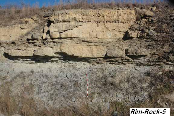
The Fort Riley Limestone Member, having a maximum thickness of 18 ft, is described as a sharply defined bench cropping out only in northwestern Pottawatomie County. There are layers of massive tan-gray coarse crystalline, porous limestone in the upper part, sometimes referred to as the "Rimrock," that weathers tan-gray and contains small limonite-stained cavities and pockets of calcite crystals. Algae are locally abundant. The lower part is generally a tan-gray thin-bedded calcareous silty shale and shaly fine-grained limestone. Both upper and lower parts are fossiliferous (Scott et al., 1959; Zeller, 1968).
There are two sites north of Olsburg where the Fort Riley Limestone was quarried and has been a source of building stone. In other counties the limestone has been evaluated as a Class 0, 1, and 2 aggregate (KDOT "A" List, 2007).
There is one site where lab analysis and testing data is available for the Fort Riley Limestone (Limestone 15).
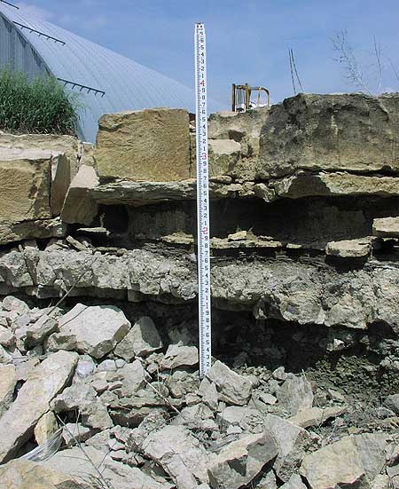
Florence Limestone Member
(SW corner of Highway K-13 and Westmoreland Rd)
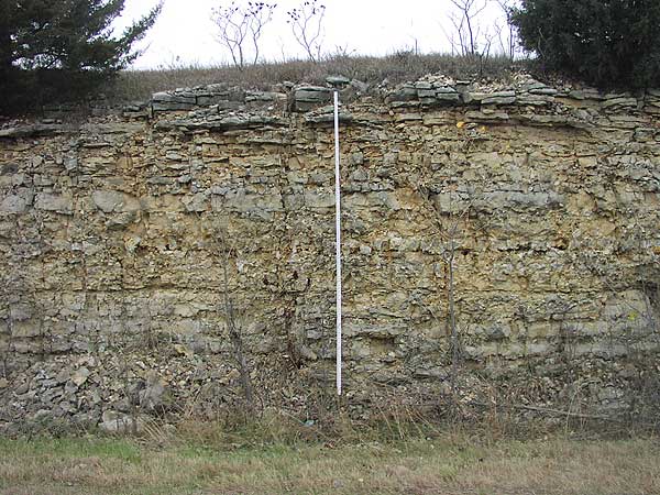
(west side of Highway 13, facing due west, measuring stick is 15 ft tall)
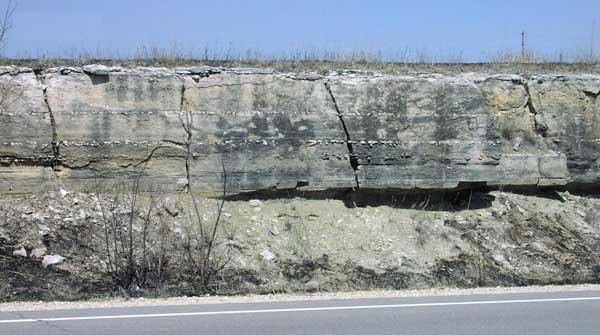
The Florence Limestone Member caps most of the buttes in the western half of the county, averages about 30 feet in thickness, and is one of the most prominent benches in Pottawatomie County. In general, the unit has abundant chert, scarce shale, and is a light-gray to yellowish-gray limestone with bluish-gray chert nodules. Fossils include brachiopods, pelecypods, bryozoans, and fusulinids. The upper part of the Florence contains distinct 8-10 inch beds of bluish-gray chert nodules alternating with beds of dense light-gray limestone. In exposed layers, the chert nodules shatter and split away from the limestone matrix probably due to water and frost action. The lower part of the Florence Limestone is made up of alternating beds of cherty gray limestone and gray calcareous silty shale (Scott et al., 1959; Zeller, 1968).
Others describe the Florence Limestone in the upper part as tan to dark gray, fine-grained, thin to medium bedded, very cherty, with scattered quartz geodes, abundant brachiopods and mollusks, and large scale cross-bedding. The lower part is gray to light brown, fine-grained, massive, with numerous thin chert bands, and fewer fossils than in the upper part (Dishman, 1969).
No tests or analyses were performed on the Florence Limestone in Pottawatomie County. The Florence Limestone was quarried in only one recorded site.
Kinney Limestone Member
(E. side of K-13, about 0.15 mi S. of Bennett Rd)

There are few good exposures of the Kinney Limestone in Pottawatomie County, and in the western half of the county, it forms a weak bench about 2-4 ft in thickness. It is described as being a massive, soft, fine-grained light-gray limestone that weathers gray and shows yellow cavities. In some localities it consists of two gray fossiliferous limestone beds separated by a gray fossiliferous shale bed or parting (Scott et al., 1959; Zeller, 1968).
In other Pottawatomie County localities, the Kinney Limestone has been described in the upper part as a blocky, dense, bluish limestone that weathers gray and pitted, locally fossiliferious (allorisma, myalina). The middle part is a green or olive bedded or fissile shale that weathers gray or buff. The lower part is a bluish, dense, massive, argillaceous platy limestone that weathers buff (Kraemer, 1934).
Others describe the Kinney Limestone in the upper part as a light tan, argillaceous limestone that weathers to rounded cobbles; the middle shale layer is light tan to tan to olive calcareous siltstone or silty shale; the lower part is a light gray, fine-grained, dense limestone with abundant small crinoid fragments and a thin basal conglomerate (Dishman, 1969).
There are no test analysis sites for the Kinney Limestone and there is no record of it having been quarried in the county.
Schroyer Limestone Member
(NW side of Highway K-13, about half-mile S. of Jacobs Rd)
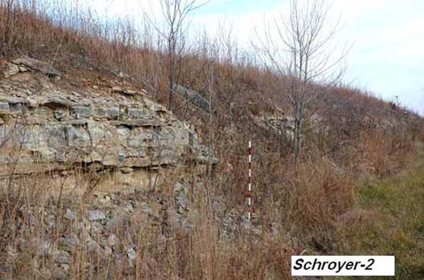
The Schroyer Limestone Member is a well developed bench, ranging 8 to 18 ft thick, in the central western and northwestern portions of the county but is sometimes obscured by Matfield Shale sediments. The unit consists of an upper part that is light gray to nearly white massive limestone, mostly chert-bearing, but commonly has a 3 ft thick non-cherty bed. The middle part is described as a cherty tan-gray fossiliferous limestone and the lower part has tan-gray calcareous silty shale beds, platy tan-gray limestone beds, and in some places a cross-bedded massive gray crystalline limestone containing flattened mudballs (Scott et al., 1959; Zeller, 1968). Others describe the Schroyer Limestone in the very upper part as gray or cream, weathers buff, recrystallized or partially recrystallized, fine-grained, sometimes oolitic with abundant ostracodes and small high spired gastropods (Stewart, 1963).
There is one lab analysis and test site for the Schroyer Limestone (Limestone 22), and at least one site in the county where the Schroyer Limestone was quarried. There are no records of paving class.
Three Mile Limestone Member
(East side of Highway K-63, 0.15 mi north of K-16 Highway)
The Three Mile Limestone Member is one of the most consistent cherty limestone members in the county in terms of thickness (7-8 ft) and lithology. The unit is light gray to nearly white limestone, and has a foot-thick massive light-gray finely crystalline limestone bed at the top and alternating bluish-gray chert layers and medium-bedded gray limestone layers. It contains massive and more resistant non-cherty beds in the middle and lower parts. Fossils are abundant and are especially well preserved on the outside of the chert nodules.
The Three Mile Limestone has been quarried for road metal but the crushed chert fragments made it less suitable for this purpose than other available limestone (Scott et al., 1959; Zeller, 1968).
No testing or analyses were performed on the Florence Limestone in Pottawatomie County. There is only one recorded site in the county where the rock was quarried. There is no available information as to its potential paving class.
Funston Limestone Member
(W. side of Highway K-99, 1 mile N. of Godlove Rd)
The Funston Limestone Member crops out in both eastern and western Pottawatomie County, but forms a more prominent bench in the east because of its increased thickness and more massive appearance. It averages about 2.5 feet thick and locally contains chert nodules. The unit is a light-gray to bluish-gray limestone separated by gray to yellowish-gray shale that commonly is abundantly fossiliferous. The upper part is massive, porous, and soft. The lower part is harder, tan-gray with a mottled salt and pepper appearance on a fresh surface, and weathers dark gray (Zeller, 1968).
The Funston Limestone has been quarried in at least three sites. Lab analysis and testing has been performed in three places (Limestone 9, Limestone 10, Limestone 12). There is no record of its paving class.
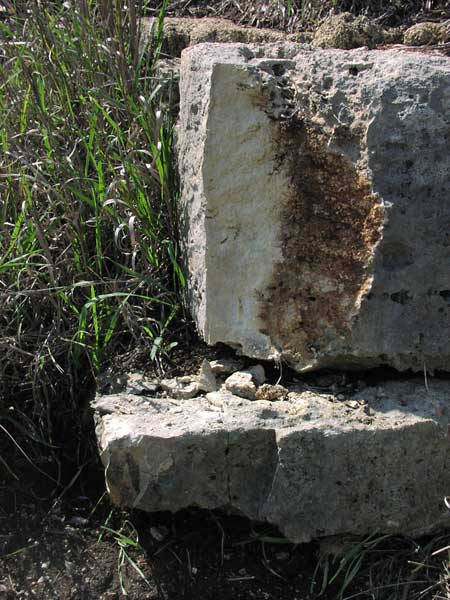
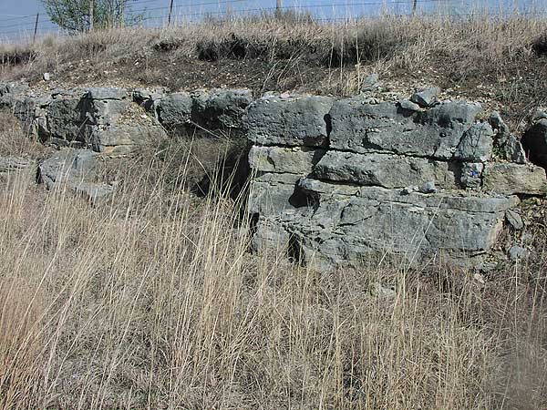
Crouse Limestone Member
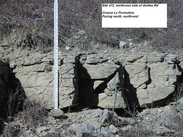
The typical Crouse Limestone crops out in the northern and western portions of the county, and has at least three limestone beds with an overall thickness of about 16 ft. The upper part is light gray, platy, dense and weather tan to brown. The softer middle and lower limestone beds are separated from the upper part by a few feet of tan-gray, clayey, fossiliferous shale (Scott et al., 1959; Zeller, 1968).
Others describe the unit as an argillaceous mudstone, laminated, wavy bedded, platy fracture, bioturbated with both horizontal and vertical burrows, yellowish gray (5Y 8/1), weathers light olive gray (5Y 6/1), both upper and lower contacts gradational. The Crouse Limestone is locally stromatolitic and vuggy (Voran, 1977).
There is no record of the Crouse Limestone being quarried but there is one lab analysis site (Limestone 4).
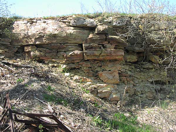
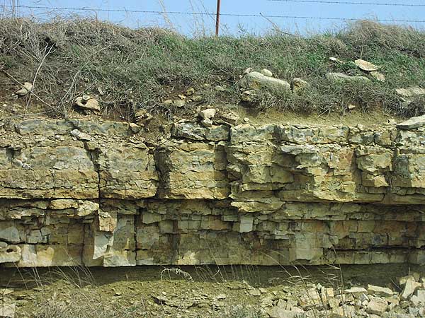
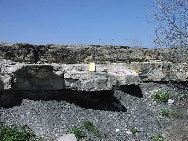
Middleburg Limestone Member
(Highway K-13, about 0.6 to 0.7 mi S. of Carnahan Rd)
In the above photo, the upper limestone outcrop is the Middleburg Limestone, which rarely exeeds 2 ft in thickness (Note: the upper limestone unit, the intervening shale unit, and the lower limestone unit in the lower right-hand corner [the Eiss Limestone] form the Bader Limestone Formation).
The Middleburg Limestone crops out in the north-central, southwestern, and east-central areas of the county, but does not form a prominent bench. It is described as a gray or tan-gray, massive, dense, fossiliferous, limonite-stained limestone (Scott et al., 1959).
There are no lab analysis sites for the Middleburg Limestone and there is no record of it having been quarried in the county.
Eiss Limestone Member
(Highway K-13, about 0.6 to 0.7 mi S. of Carnahan Rd)
In the above photo, the lower limestone outcrop is the Eiss Limestone.
The Eiss Limestone crops out in various locations all around the county and forms a prominent bench between 4.5 and 10 ft thick. The unit is made up of an upper and lower limestone bed with an intervening, fossiliferous calcareous light-gray clayey shale. The upper bed, generally 2 to 3 ft in thickness is massive, cavernous when weathered, siliceous, and locally cherty. The lower bed is 1.5 to 6 ft in thickness and is shaly, thin-bedded, and contains abundant small, high-spired gastropods (Scott et al., 1959; Zeller, 1968).
There is no record of the Eiss Limestone having been quarried in the county, but there are two lab analysis sites (Limestone 8 and Limestone 11).
Morrill Limestone Member
(outcrop located above Spring Creek 100 yards S. of K-16)
The Morrill Limestone unit is a brown to grayish-brown argillaceous limestone that contains one or more thin shale partings, with thicknesses ranging from 2 to 9 ft. The unit is also described as generally consisting of two or more gray or light-gray limestone beds separated by thin light-gray clayey shale beds, is dense, hard, fossiliferous, in some places contains calcite geodes, and averages about 3.5 ft in thickness. A particularly thick 10 ft layer was described in the SW, NW, Sec. 10, T. 6 S., R. 8 E. with only about 4 ft of Florena Shale separating it from 7 ft of the Cottonwood Limestone (Scott et al., 1959; Zeller, 1968).
There are no lab analysis sites for the Morrill Limestone and there is no record of it having been quarried in the county.
Cottonwood Limestone Member
(W. side of Hwy 13, 0.4 mi NE of Dyer Rd [Tuttle Creek Dam])
The Cottonwood Limestone Member forms a characteristic shrub-lined prominent bench ranging 5-7 ft in Pottawatomie County. The unit is massive, light-buff, weathering nearly white, cherty with abundant fusulinids in the upper part. In southern Kansas and in some localities it is thin-bedded and shaly. In Kansas, the thickness is fairly constant at around 6 ft, although the unit thins toward the south of the state. (Scott et al., 1959; Zeller, 1968).
The Cottonwood Limestone has also been described, in the upper part, as fine calcirudite, packstone, gray to medium gray, weathering to yellow-gray, massive, with abundant fusulinids, scattered crinoids, and bedded chert 8-12 in. above the base. The lower part of the Cottonwood is medium calcilutite, wackestone, light-gray to gray, blocky or slabby, with common productids, crinoids and composite. It is locally argillaceous (Bogina, 1989).
The Cottonwood Limestone has been quarried in numerous locations in Pottawatomie County. Lab analysis and testing data are available in five locations (Limestone 5, Limestone 7, Limestone 13, Limestone 17, and Limestone 24).
Neva Limestone Member (according to geo map)
(SE corner of Rock Creek Rd and Flush Rd, about 1 mi W. of Hwy 99)
The Neva Limestone Member is currently one of the most extensively quarried limestone units in Pottawatomie County. The unit, ranging 10-20 ft, has gray limestone beds interbedded with gray and grayish-green shale beds. A fresh exposure gives an appearance of being a single bed but when weathered, it breaks down into four or five limestone beds with intervening silty shale beds. It has a basal bed of gray algal limestone 0.4-3.7 ft, overlain by a medium-gray to very dark-gray silty calcareous shale 3 ft thick. The main limestone ledge is a gray, massive limestone 1.8-14.4 ft thick. This bed has a brecciated, porous appearance with a diverse fauna of fusulinids, brachiopods, echinoids, and algae. The middle-upper layers contain a 3 ft gray to grayish-green fossiliferous shale, followed by the upper limestone layer of gray, fossiliferous limestone, and averaging about a half-foot to 6 ft in thickness (Scott et al., 1959; Zeller, 1968).
The Neva Limestone has been quarried in numerous locations throughout Pottawatomie County for road rock and Class 1 and 2 aggregate (KDOT "A" Listing, 2007). There are seven sites where lab analysis and testing has been performed (Limestone 6, Limestone 16, Limestone 18, Limestone 23, Limestone 25, Limestone 26, and Limestone 30).
Burr Limestone Member
(no photo available)
The Burr Limestone, about 8 ft in thickness, consists of two limestone beds separated by shale. The beds are massive, fine-grained, tan-gray, and fossiliferous, with the upper part being soft, porous, and containing small cavities; the lower part is hard, clayey, and weathers blocky. The intervening shale is a fissile black or olive-drab clay (Scott et al., 1959).
Others describe the Burr Limestone as tan, weathering gray, massive, and dense. The upper portion is generally 2.5 ft thick with an ostracode zone on the very upper surface, and the lower portion, also 2.5 to 3 ft in thickness, is brown, weathering buff, massive, dense, fine crystalline, with calcite-filled vugs. The intervening shale unit is typically 1 to 1.5 ft in thickness and is a friable black fissile or platy shale with a scattered burrow and root mottled appearance (Snyder, 1968, Bogina, 1989).
There is at least one record of the Burr Limestone being quarried in the north-central area of Pottawatomie County, and this site was abandoned in 1968. There are two sites where lab analysis and testing was performed (Limestone 21 and Limestone 29). There is no record of paving class.
Sallyards Limestone Member
(no photo available)
The Sallyards Limestone is described as a massive, hard, dense light-gray limestone that weathers blocky. The upper part is fossiliferous in some outcrops, and the unit averages about 1 ft in thickness (Scott et al., 1959).
Other descriptions depict the Sallyards as a light gray, massive, dense, hard, argillaceous limestone that weathers blocky, contains crinoid columnals, brachiopods, pelecypods, and other fossil fragments, also about 1 ft in thickness. Outcrops to the north of Pottawatomie County also indicate a yellowish gray limestone weathering to tan, porous in lower 3 in., massive, dense in upper portion, medium hard and up to about 3 ft thick (Avers, 1968).
There are no test analysis sites for the Sallyards Limestone and there is no record of it having been quarried in the county.
Howe Limestone Member
(Tuttle Creek Spillway)
Underlain by Bennett Shale
The Howe Limestone Member (4.5 ft thick in Pottawatomie County) is a persistent uniform gray to grayish-brown, fine-grained algal limestone with tiny pelecypods, and gastropods, ostracodes, and foraminifers. The Howe Limestone is also described as forming a poorly defined bench, and generally consisting of two or more massive tan or tan-gray beds, with the upper being harder and more resistant to weathering. The lower part is iron-stained, and is separated from the upper part by a blocky calcareous light-gray or tan-gray silty shale (Scott et al., 1959; Zeller, 1968).
There is no record of the Howe Limestone being quarried in Pottawatomie County, but there is one site in the northeast part of the county where a lab analysis and test was conducted (Limestone 1). The Howe Limestone has been quarried in Cowley County, Kansas for a Class 0 and Class 2 aggregate (KDOT "A" Listing, 2007).
Glenrock Limestone Member
(Tuttle Creek Spillway)
The Glenrock Limestone Member, up to 3 ft in thickness in southern Nebraska, is described as a gray to brownish-gray limestone with brachiopods, algae, gastropods, abundant fusulinids, and other smaller foraminifers. Others describe the unit as a massive, dense, petroliferous gray or tan-gray limestone between 0.5 and 1.6 ft thick in Pottawatomie County, fossiliferous, and locally has a brecciated appearance. The unit is absent in Wabaunsee County just south of Pottawatomie County (Scott et al., 1959; Zeller, 1968).
There are no test analysis sites for the Glenrock Limestone and there is no record of it having been quarried in the county. There is a record of the Glenrock Limestone being quarried as a Class 0 and Class 2 aggregate in Cowley County, Kansas (KDOT "A" Listing, 2007).
Long Creek Limestone Member
(no photo available)
The Long Creek Limestone, 6 to 7.3 ft thick, is a massive, clayey, dolomitic tan or gray-brown limestone containing jasper and pockets of crystalline quartz, calcite, and celestite. Extensive iron stains occur near the base. Fossiliferious, lower beds contain abundant fusulinids (Scott et al., 1959).
Others describe the upper 2.3 ft of the Long Creek Limestone being yellowish brown to orange, porous and hard, containing honey-comb structure, pores filled with clay-size material, with the middle portion being light to medium brown, weathering to tan, soft, and containing calcite geodes. The lower portion is a massive, porous, calcareous, argillaceous yellowish-brown siltstone (Avers, 1968).
There are no test analysis sites for the Long Creek Limestone and there is no record of it having been quarried in the county.
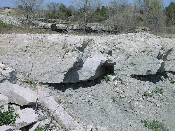
Americus Limestone Member
(E. side of Camp Creek Rd, about 1/3 mi N. of Oregon Trail Rd)
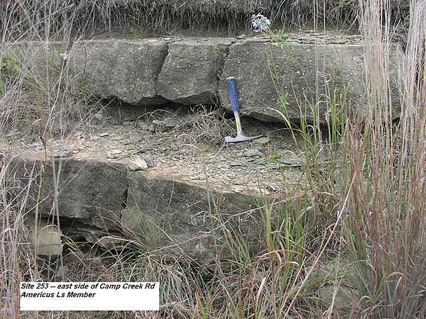
The Americus Limestone Member consists of two gray to bluish-gray limestone beds separated by a medium-gray to very dark-gray shale bed. The thickness ranges from 1.5 to 20 ft, although in Pottawatomie County the average is generally 2 to 4.5 ft. The upper and lower limestone beds are very fossiliferous (crinoids, brachiopods, bryozoans, pelecypods, fusulinids, and algae). In some outcrops, partly silicified algal nodules are present on the upper surface of the lower part of the unit (Scott et al., 1959; Zeller, 1968).
Others describe the upper part as a brachiopod or echinodermlime packstone, hard, dense, light gray or light to pinkish gray. The lower part is a foraminifer or ostracode coated grain lime wackestone-packstone, hard, dense, thin-bedded, with an algal lime boundstone at the base. The shale between is fissile to blocky, calcareous, light gray to gray to dark gray (Peterson, 1978).
The Americus Limestone forms a distinct bench that and has been quarried as a building stone material in southeast Pottawatomie County. No paving class data is available. There is one lab analysis and test site (Limestone 27).
Five Point Limestone Member
(S. side of Grange Rd, 1 mi W. of Dutch Creek Rd)
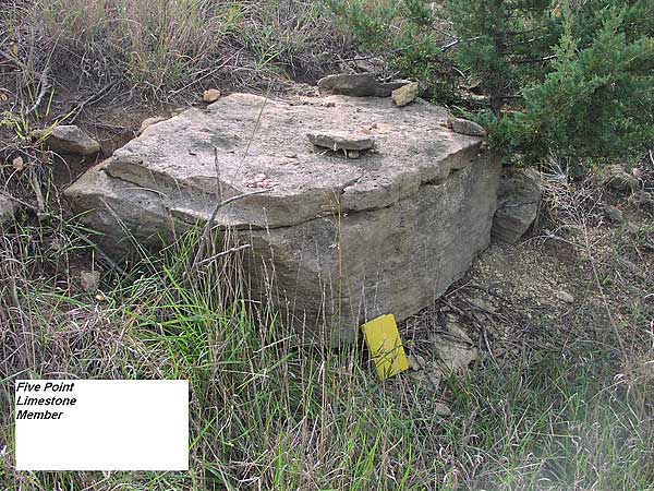
The Five Point Limestone Member has been described as a massive hard coarse-grained tan or tan-gray coquinoidal limestone with variable thickness rarely exceeding 2 ft (Scott et al., 1959). It is also described as a unit that locally consists of an upper and lower bed, with a local thin green calcareous, fossiliferous shale in between, with the entire unit ranging in thickness from 2.3 to 3.3 ft. The upper bed is light gray to moderate orange pink (10R 7/4), weathering buff to dark buff, locally massive, porous, coquinoid, with brachiopods, crinoid columnals, and gastropods. The lower bed is grayish-green, slabby, with abundant fusulinids, bryozoans, brachiopods, crinoid columnals, and gastropods (Bernasek, 1967).
While not extensively quarried, the limestone is quarried as a building stone, especially near Duluth in Pottawatomie County where it is pink. There is one site where a lab analysis and test was performed (Limestone 3). No paving class data is available.
Falls City Limestone Member
(no photo available)
The Falls City Limestone in northeastern Kansas consists of an upper and lower fossiliferious limestone bed separated by gray shale containing fossiliferous carbonate lenses. The unit ranges 1 to 3 ft in thickness in Pottawatomie County. Both beds are argillaceous and fossils include mollusks, bryozoans, and brachiopods. More locally, the Falls City Limestone is a massive, dense brown limestone that weathers to small brown blocks with brown dendrites on surfaces (Scott et al., 1959; Zeller, 1968).
There are no lab analysis sites for the Falls City Limestone and there is no record of it having been quarried in the county.
Aspinwall Limestone Member
(N. side of Mt. Calvary Rd, about 0.35 mi E. of Shawnee Rd)
In Pottawatomie County the unit forms a thin bench. The Aspinwall Limestone is massive, laminated, contains clay balls flattened parallel to bedding. It has a mottled appearance with brown, gray-brown, and tan-gray streaks, and ranges in thickness from 0.6 to 4.2 ft (Scott et al., 1959).
Others describe the Aspinwall Limestone as a skeletal calcilutite; platy; pale yellowish brown (10YR 6/2), weathering to a moderate yellowish brown, (10YR 4/2). It contains rounded clay fragments (1-3 mm), is sparely fossiliferous with productacean brachiopod fragments, echinoid spines, and other skeletal debris fragments (Bisby, 1986).
No record of commercial quarrying exists. Regular, rectangular jointing allowed the Aspinwall Limestone to be used as structural stone in small bridges. There is one analysis and test site (Limestone 19).
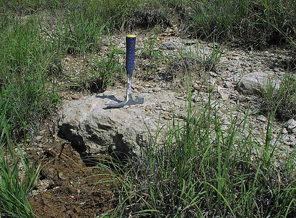
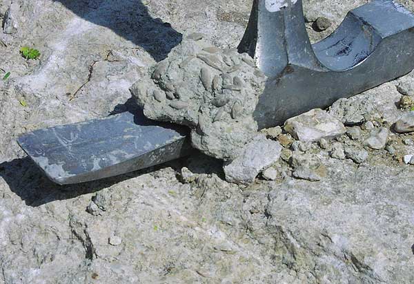
Brownville Limestone Member
(N. side of Cow Creek Rd, about 0.7 mi W. of K-63)
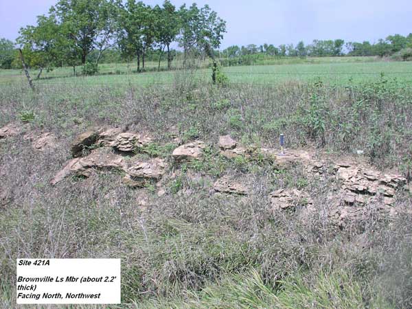
The Brownville Limestone forms a thin (2-3.5 ft) but persistent bench near Maryville and along Vermillion Creek, and is made up of upper and lower massive, dense fossiliferous limestone beds that weather tan and blocky or nodular. The two beds are separated by a fossiliferious tan-gray silty shale (Scott et al., 1959).
The upper bed gray weathers yellowish-brown, blocky; brachiopods (Marginifera and Chonetes), bryozoans, and crinoid columnals. The lower bed is greenish-gray, weathers buff, is massive, argillaceous, limonitic, fossiliferous (brachiopods, crinoids) and contains a very thin gray calcareous shale (Bernasek, 1967).
The Brownville Limestone Member has been quarried in at least one site in Pottawatomie County and there is one lab analysis and test site (Limestone 20). No paving class data is available.
Grayhorse Limestone Member
(no photo available)
Only a few outcrops exist in the county. The Grayhorse Limestone is hard, slightly porous, tan to tan brown, and contains limonite and clay balls. The unit weathers blocky, has a conglomeratic appearance, and is half a foot to 2 ft thick (Scott et al., 1959).
There are no test analysis sites for the Grayhorse Limestone and there is no record of it having been quarried in the county.
Nebraska City Limestone Member
(no photo available)
Only a few outcrops exist in the county. The Nebraska City Limestone, ranging in thickness from 1 to 1.5 ft, is described as a massive single bed of metallic-gray or mottled blue and gray fossiliferous limestone that weathers mottled brown and gray shaly limestone (Scott et al., 1959).
There are no test analysis sites for the Nebraska City Limestone and there is no record of it having been quarried in the county.
Jim Creek Limestone Member
(no photo available)
The Jim Creek Limestone weathers tan gray and blocky or nodular, ranging 1 to 2.5 ft in thickness. It is massive, fossiliferous, and on a fresh surface is tan mottled with light green (Scott et al., 1959).
Others describe the Jim Creek Limestone in some State of Nebraska outcrops as dark gray, weathers light greenish gray, splits into slabby plates, and contains crinoid columnals and broken shell fragments (Girardot, 1962).
There are no test analysis sites for the Jim Creek Limestone and there is no record of it having been quarried in the county.
Grandhaven Limestone Member
(no photo available)
This unit is believed to be undifferentiated in Pottawatomie County but would lie between the Dry and the Friedrick shale members (Scott et al., 1959).
There are no test analysis sites for the Grandhaven Limestone and there is no record of it having been quarried in the county.
Dover Limestone Member
(no photo available)
The Dover Limestone, averaging 2.5 to 3 ft in thickness, is a massive, dense, hard gray limestone that weathers light brown and nodular, and resembles the Tarkio Limestone. Both have large fusulinids, but the Dover Limestone has more corals and Osagia, a gray algal nodule 1 to 2 in. in diameter (Scott et al.,1959).
There is no record of the Dover Limestone having been quarried in Pottawatomie County, but there is one lab analysis and test site (Limestone 28).
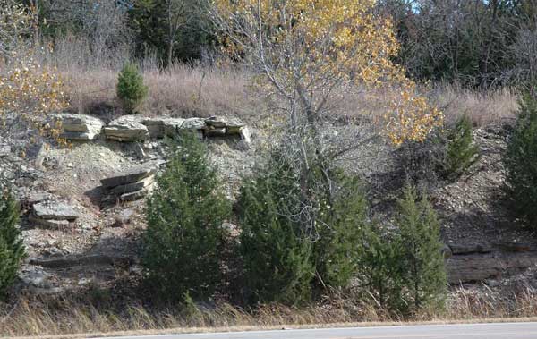
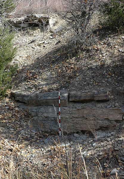
Maple Hill Limestone Member
(photo tentatively identified as Maple Hill, as indicated by geological map)
(N. side of Highway US 24, 0.35 mi E. of Salzer Rd)
(Maple Hill Limestone close-up showing abundant fusulinids)
(N. side of Highway US 24, 0.35 mi E. of Salzer Rd)
The Maple Hill Limestone, ranging 1.8 to 3 ft in thickness, resembles the Tarkio in appearance, but the bench is less well-defined. The unit is massive, dense, dark gray, weathers light brown, forms rectangular blocks, and contains abundant small fusulinids (Scott et al., 1959).
There are no test analysis sites for the Maple Hill Limestone and there is no record of it having been quarried in the county.
Tarkio Limestone Member
(no photo available)
Development has erased most evidence of the old quarries and it is difficult to find a good Tarkio Limestone exposure in the area. The unit, up to 8 ft in thickness in the south and up to about 4 ft in the north, crops out as a very prominent bench in the south-central and northeastern portions of the county. It has been described as a light-gray or tan-gray massive, dense limestone that weathers slabby or blocky with large fusulinids (Scott et al.,1959).
Other descriptions include the Tarkio Limestone, with a thickness up to 10 ft, as gray and brown, massive but deeply weathered, containing giant fusulinids (Triticites ventricosus) (Harding, 1950).
The Tarkio Limestone has been quarried extensively in Pottawatomie County, particularly in the area around Wamego and St. George for road riprap. In neighboring Riley County the member has met Class 2 aggregate standards (KDOT "A" Listing, 2007). There is one lab analysis and test site (Limestone 31).
Elmont Limestone Member
(N. side of Hwy 16, W. of Kelley Creek Rd)
The Elmont Limestone Member (2-5 ft in thickness) forms a prominent bench in the south central and northeast portions of Pottawatomie County. The base of the Elmont Limestone is a thin bluish-gray conglomeric limestone overlain by 0.3 to 4 ft of clayey, calcareous gray shale containing Derbyia and Chonetes. The middle part is characterized as having vertical joints and is a persistent, dense, bluish-gray limestone containing small fusilinids, algae, brachiopods, and crinoid fragments. The upper part is a few inches up to 1 ft gray calcareous shale overlain by a thin algal-molluscan limestone (Scott et al., 1959; Zeller, 1968).
The Elmont Limestone has also been described in the lower part as an intrasparudite, brown to yellowish-brown, weathering grayish to yellowish brown with conchoidal fractures. Fossils include possible Osagia, Anchicodium, and Bellerphon. The upper part has been characterized as a biosparite, brown to yellowish brown, weathers yellowish to grayish brown to brown, dense, massive, locally containing hard platy limonitic fragments on the upper surface. Fossils include fusulinids, crinoidal columnals, fenestrate bryozoans, Osagia, Anchicodium, Bellerphon, Marginifera, and Chonetes (Renfro, 1963).
The Elmont Limestone was quarried at a couple of sites in Pottawatomie County although the quarries were abandoned as far back as 1952. There is no lab analysis site available and there is no paving class data available.
Reading Limestone Member
(N. side of Hwy 16, W. of Kelley Creek Rd)
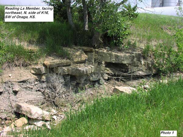
The Reading Limestone Member primarily outcrops in northeastern Pottawatomie County, and commonly consists of usually three massive, hard, dense fossiliferous limestone beds averaging between 2 and 3 ft in thickness. A sometimes non-persistent lower bed is dark gray, crystalline. The middle bed is gray with fossil shells and calcite-lined cavities. The upper beds are gray or brown. Thin silty limonitic shale layers separate the limestone beds (Scott et al., 1959).
The unit, which in other parts of Kansas can vary between 1.5 to 15 ft in thickness, is also described as consisting of one to four limestone beds interbedded with a blue-gray shale and in southeastern Kansas it contains a coal bed. The most persistent part of the Reading Limestone is a dark bluish-gray, dense, hard limestone with closely spaced vertical joints that weathers light bluish-gray mottled with light brown or yellowish-brown. Fusulinids are characteristic of the main part of the unit although locally it contains algae (Zeller, 1968).
The Reading Limestone was quarried at several sites in Pottawatomie County although the quarries were abandoned as far back as 1952. There is one test analysis site available (Limestone 2). No paving class data is available.
Wakarusa Limestone Member
(no photo available)
The Wakarusa Limestone Member, ranging 3 to 5.7 ft in thickness, forms a well-defined bench in the south-central and northeastern parts of the county and consists of several massive or shaly limestone beds separated by thick shale layers. The unit is tan-gray or gray, weathers tan gray, gray, light rose or red brown and is marked by dendrites. The Wakarusa Limestone contains abundant fossils (Scott et al., 1959).
There are no test analysis sites for the Wakarusa Limestone and there is no record of it having been quarried in the county.
Burlingame Limestone Member
(no photo available)
The Burlingame Limestone Member (1-3 ft thick) is characterized by a single persistent bed of massive conglomeratic tan or tan-gray limestone containing flattened clay balls. In some locations, a second massive tan limestone bed exists on top of the first bed, separated by a calcareous tan-gray silty shale. The lower bed is generally 1 to 1.6 ft in thickness, but where both limestone beds exist, the entire unit can be up to 3 ft in thickness. The Burlingame Limestone is limonitic and contains abundant large and small fusulinids (Scott et al., 1959).
There are no test analysis sites for the Burlingame Limestone and there is no record of it having been quarried in the county.
Rulo Limestone Member
(no photo available)
The Rulo Limestone is considered to be the very lowest stratigraphic member of Pottawatomie County. The Rulo Limestone is described as being a massive, dense, hard, dark-gray or tan limestone that is platy or shaly and weathers brown, averaging 1.5 ft in thickness (Scott et al., 1959).
There are no test analysis sites for the Rulo Limestone and there is no record of it having been quarried in the county.
Bibliography
Avers, D.D., 1968, Stratigraphy of the lower part of the Council Grove Group (Early Permian) in southeastern Nebraska and eastern Kansas: Unpubl. M.S. thesis, Department of Geology, University of Nebraska, Lincoln, NE, 199 pages.
Bernasek, R.A., 1967, Stratigraphy of the Admire Group ("Early Permian") in southeastern Nebraska and eastern Kansas: Unpubl. M.S. thesis, Department of Geology, University of Nebraska, Lincoln, NE, 150 pages.
Bisby, C.G., 1986, Depositional environments of the Wood Siding Formation and the Onaga Shale (Pennsylvanian-Permian) in northeast Kansas: Unpubl. M.S. thesis, Department of Geology, Kansas State University, Manhattan, KS, 73 pages, (avail. as Kans. Geol. Survey, Open-file Rept., no. 86-4).
Bogina, M.A., 1989, Hierarchal genetic stratigraphy of the Neva Limestone Member of the Grenola Limestone and Eskridge Shale (Lower Permian) in northeastern Kansas: Unpubl. M.S. thesis, Department of Geology, Kansas State University, Manhattan, KS, 187 pages, (avail. as Kans. Geol. Survey, Open-file Rept., no. 89-37).
Dishman, B.D., 1969, Stratigraphy and cyclic deposition of portions of the Council Grove and Chase groups (Permian) in Nebraska and Kansas: Unpubl. M.S. thesis, Department of Geology, University of Nebraska, Lincoln, NE, 223 pages.
Girardot, S.L., 1962, Stratigraphy and Sedimentation of the Wabaunsee Group (Upper Pennsylvanian) in Southeastern Nebraska and Adjacent Regions: Unpubl. M.S. thesis, Department of Geology, University of Nebraska, Lincoln, NE, 104 pages.
Harding, K.S., 1951, The stratigraphy and lithology of the Indian Cave Sandstone in southeastern Nebraska and northeastern Kansas: Unpubl. M.S. thesis, Department of Geology, University of Nebraska, Lincoln, NE, 55 pages.
Kansas Dept. of Transportation, 2007, "A" Listing, 58th edition of limestone sources tested by KDOT: Kansas Department of Transportation, Topeka, Kansas, July 2, 2007
Kraemer, J. L., 1934, Traverse of the Big Blue Series from the Nebraska-Kansas State Line to Manhattan: Unpubl. MS thesis, Department of Conservation and Survey, University of Nebraska, Lincoln, NE, 95 pages.
Peterson, R. M., 1978, Biofacies analysis of the uppermost Hamlin Shale and the Americus Limestone (Permian, Wolfcampian) in northeastern Kansas" Unpubl. PhD thesis, Department of Geology, University of Kansas, Lawrence, Kansas.
Renfro, A.R., 1962, Depositional History of the Elmont Limestone: Unpubl. MS thesis, Department of Geology and Geography, Kansas State University, Manhattan, KS, 68 pages.
Scott, G.R., Foster, F.W., and Crumpton, C.F., 1959) Geology and Construction-Material Resources of Pottawatomie County, Kansas: U.S. Geological Survey, Bulletin 1060-C, Washington, D.C. [available online]
Snyder, B.L., 1968, Stratigraphy of the Middle Part of the Council Grove Group (Early Permian) in the Northern Midcontinent: Unpubl. M.S. thesis, Department of Geology, University of Nebraska, Lincoln, NE, 157 pages.
Stewart, J.W., 1963, Lithologic investigation of the Schroyer limestone in Pottawatomie, Riley, and Geary counties, Kansas: Unpubl. M.S. thesis, Department of Geology, Kansas State University, Manhattan, KS, 54 pages.
Voran, R.L., 1977, Fossil assemblages, stratigraphy, and depositional environments of the Crouse Limestone (Lower Permian) in north central Kansas: Unpubl. M.S. thesis, Department of Geology, Kansas State University, Manhattan, KS, 208 pages.
Zeller, D.E., ed., 1968, The Stratigraphic Succession in Kansas: Kansas Geological Survey, Bulletin 189, Lawrence, KS. [available online]