Kansas Geological Survey, Public Information Circular (PIC) 9
Prev. Page--Start of the Report || Next Page--Sustainable Development
![]()
![]()
![]()
![]()
Kansas Geological Survey, Public Information Circular (PIC) 9
Prev. Page--Start of the Report ||
Next Page--Sustainable Development
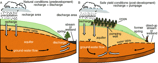
Precipitation and surface water that percolate through the soil and reach the aquifer are called recharge. Ground water slowly flows through the aquifer from areas of recharge (usually uplands) to areas of discharge (usually lowlands), such as springs, streams, or wetlands. Under natural conditions (prior to development by wells), aquifers are in a state of approximate dynamic equilibrium, which means there is a balanced inflow and outflow of water in the system (fig. 2A). Over hundreds of years, wet times (in which recharge exceeds discharge) offset dry times (when discharge exceeds recharge). Pumping water from wells upsets this balance, oftentimes causing water-table levels to drop (fig. 2B), thereby producing water loss from aquifer storage.
Figure 2--Stream-aquifer interaction. A) Under natural conditions (prior to development by wells), aquifers are in a state of balance; inflow (recharge) equals outflow (discharge). B) Pumping may lower the water table, causing springs, streams, and wetlands to dry up; in this instance, recharge equals pumping.
The decline of ground-water levels around pumping wells located near streams captures some of the ground-water flow that would have, without pumping, been discharged to the streams. In fact, if enough water is pumped out of the aquifer, these declining ground-water levels can induce flow out of a body of surface water into the aquifer, a process known as induced recharge. The sum of these two effects leads to streamflow depletion.
As pumping continues, a new state of dynamic equilibrium can be reached only when the amount of water removed from the aquifer is balanced by an increase in recharge (i.e., induced recharge), a decrease in natural discharge, a loss of storage in the aquifer, or a combination of these factors (Theis, 1940). Thus, pumping uses water from two sources, induced recharge and ground-water storage.
Since permanent streamflow is usually a result of ground-water discharge, lowering the water table below that of the streambed will reduce, or perhaps stop, streamflow. The same thing happens to wetlands and springs. Because streamflow is sometimes a source of recharge to some aquifers, a reduction in streamflow can also affect ground-water levels.
Problems in the Smoky Hill River watershed, described below, illustrate these interconnections between streams and aquifers.
In short, ground water and surface water are both part of a very complex hydrologic system, in which the alteration of one part affects all of the system. Surface and ground water are not separate components, and development of either water resource must be based on an understanding of the whole system.
Sometimes a decision about one aspect of a water system in Kansas has an impact on a variety of systems, impacts not necessarily intended or even recognized when the original decision was made.
In 1951, the Bureau of Reclamation constructed Cedar Bluff Dam on the upper reaches of the Smoky Hill River in Trego County in west-central Kansas. Cedar Bluff captures drainage from the Smoky Hill and two of its major tributaries. The dam was intended to provide flood control, water for irrigation and municipal use, and water for a fish hatchery. Shortly after the dam was completed, heavy spring and summer rains in 1951 and 1957 filled the reservoir. In the mid-1960's, however, inflow into the reservoir slowed substantially. Decreased inflow to Cedar Bluff was attributed to a lessening of streamflow related to lower water tables and the increased use of conservation practices in agriculture, such as terracing and building of farm ponds, that dramatically decreased runoff. Because of this lack of inflow, the contents of Cedar Bluff Reservoir averaged only about 13% of the designed level from 1980 to 1987 (Ratzlaff, 1987). Releases of water from Cedar Bluff to entities with water rights were curtailed in 1979.

Hays, Kansas, a city of about 18,000 people, is about 22 miles (35 km) downstream from Cedar Bluff Reservoir and about 10 miles (16 km) north of the Smoky Hill River. One of the city's primary water sources is a well field in the alluvial aquifer of the Smoky Hill River, which produced about 2,500 acre-feet of water annually. Lessened streamflows in the Smoky Hill--caused by the lower water tables, decreased runoff, and the lack of discharge from the reservoir--meant that considerably less water was available in the Smoky Hill to recharge the alluvial aquifer. Yields in the Hays well field dropped to about 1,000 acre-feet annually. Because of dwindling water supplies, Hays began a number of conservation efforts, resulting in a substantial reduction in per capita water use. The city also began aggressively seeking additional water sources, and eventually purchased land and water rights to a ranch in Edwards County, Kansas, about 85 miles (136 km) away, with plans of transferring water for municipal use in Hays, in spite of considerable opposition to the plan in Edwards County.
In short, then, lessened streamflow in the Smoky Hill River had the domino effect of lessening supplies in Hays, leading to the possible transfer of water away from the Arkansas River drainage basin, more than 100 miles (160 km) away from Cedar Bluff. The reservoir's construction, along with other factors, had a variety of consequences--related to agricultural, municipal, and irrigation water supply, as well as streamflow--that reverberated far beyond the simple building of a dam in Trego County.
Prev. Page--Start of the Report || Next Page--Sustainable Development
Glossary || Water Budget of Kansas
Kansas Geological Survey, Public Outreach
Web version February 1998
http://www.kgs.ku.edu/Publications/pic9/pic9_2.html