Kansas Geological Survey, Public Information Circular (PIC) 8
Prev. Page--Start of the Report || Next Page--Summary and Glassary
![]()
![]()
![]()
![]()
Kansas Geological Survey, Public Information Circular (PIC) 8
Prev. Page--Start of the Report ||
Next Page--Summary and Glassary
Because of the highly variable conditions in the Dakota aquifer system and the variable impacts of pumping, different management strategies are needed in different regions of the state. To assist local and state water agencies in managing this resource, the KGS has divided the Dakota aquifer into six water-supply-suitability areas. A water-supply-suitability area is defined by the KGS as a region of the Dakota aquifer in which the hydrologic and water-quality characteristics, as well as the impacts of pumping on the hydrologic system, are relatively uniform. The proposed boundaries between the suitability areas shown in figure 4 mark significant changes in these characteristics or in the response of the hydrologic system to pumping.
In comparison to the High Plains and other shallow aquifers, the Dakota remains a relatively unknown aquifer system in Kansas. Therefore, the boundaries between suitability areas may change as new information becomes available. Also, the rate and intensity of development may necessitate the adjustment of these boundaries. Nonetheless, these water-supply-suitability areas are useful in the formulation of management strategies. The KGS is not suggesting the creation of regulatory bodies to manage each of these suitability areas. Rather, it is our intent that these suitability areas be incorporated into the formulation of policies and plans by the existing local and state water agencies. With the recognition of these suitability areas, it may be possible for these agencies to more fully address the sustainability of the hydrologic system, which includes both surface and ground waters.
Figure 4--Map showing the six water-supply-suitability areas of the Dakota aquifer in western and central Kansas. In suitability areas IV and V, the dashed line separates fresher ground waters to the south and west from more saline ground waters (salinities greater than 1,500 mg/L) to the north and east.
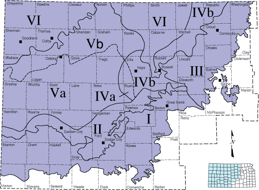
Suitability Area I encompasses the region where the Dakota and the High Plains aquifers are hydraulically connected in southwestern and south-central Kansas (figs. 1, 4). Where the High Plains is thickest, the depth below the surface to the top of the Dakota aquifer is more than 500 feet (152 m). In western Stanton, western Morton, and southern Hamilton counties, the High Plains aquifer is absent or is very thin and the Dakota aquifer is the primary shallow aquifer. Ground water in the upper Dakota aquifer is fresh throughout this suitability area (fig. 3). However, ground-water chemical quality is variable in the lower Dakota aquifer because of the small amount of freshwater recharge that passes through the Kiowa shale aquitard. Ground-water salinities may exceed 2,000 mg/L (too high for human consumption but usable for livestock) in some parts of the lower Dakota. Nearer the Kansas-Colorado border and the Dakota's southern extent in southwestern Kansas, the lower Dakota contains freshwater because of its proximity to the regional recharge area in southeastern Colorado and local recharge from the High Plains aquifer. In this suitability area, the Dakota is used for drinking, industry, and agriculture, including irrigation. Water-level declines in the Dakota from previous development are generally less than 50 feet (15 m) in Suitability Area I.
Because the Dakota and the High Plains aquifers are hydraulically connected, they behave as a single system in this suitability area. The water-management policies developed for one of the aquifers will eventually have an impact on the other. Consequently, it is appropriate to consider both aquifer systems in policy development.
In Suitability Area II, the Dakota aquifer is confined by the Upper Cretaceous aquitard. This area is adjacent to Suitability Area I, where the Dakota is hydraulically connected to the High Plains aquifer (figs. 1, 4). The depth below the surface to the top of the Dakota aquifer is less than 400 feet (122 m) over most of this area. Because the aquitard is thin, recharge from overlying sources to the upper Dakota aquifer is significant, though less than the amount withdrawn by pumping. Ground water in the upper Dakota is fresh (less than 1,000 mg/L) over most of the region (fig. 3). Ground-water salinity in the lower Dakota is believed to be less than 5,000 mg/L in the western half and more than 5,000 mg/L in the eastern half of the area. The upper Dakota is used for drinking water, industry, and agriculture, including irrigation. Use of the Dakota for irrigation is more common in Hodgeman and Ford counties. Water-level declines from previous development are generally less than 50 feet (15 m). Pumping wells in the Dakota aquifer in Suitability Area II may increase recharge from the High Plains aquifer into the Dakota aquifer in Suitability Area I.
Prev. Page--Start of the Report || Next Page--Summary and Glassary
Kansas Geological Survey, Public Outreach
Web version June 1997
http://www.kgs.ku.edu/Publications/pic8/pic8_2.html