Kansas Geological Survey, Public Information Circular (PIC) 7
Next Page--Well Yields
![]()
![]()
![]()
Kansas Geological Survey, Public Information Circular (PIC) 7
Next Page--Well Yields
P. Allen Macfarlane
In the last decade, the need to identify alternative water sources for the western and central parts of Kansas has sparked interest in the Dakota aquifer and highlighted the need for improved understanding of its flow system and water quality. The Dakota aquifer system consists of sandstone bodies deposited about 100 million years ago during the Cretaceous Period. These formations are found at the surface and in the subsurface in most of the western two-thirds of Kansas. Kansans, and others in the Great Plains region, have used the Dakota as a source of water for more than a century. However, until recently, not much was known about how water moves through the Dakota aquifer or the water's source. In 1988 the Kansas Geological Survey began a comprehensive program of research on this aquifer system. This publication summarizes some of the information derived from this research. Terms printed in boldface type are defined in the Glossary at the end of this publication.
Ground water from the Dakota aquifer is used for domestic, municipal, industrial, and agricultural purposes, primarily where the aquifer is near the surface in southwestern and central Kansas. In southwestern Kansas, the Dakota is used in conjunction with the overlying High Plains aquifer (the Ogallala and associated shallow aquifers) as a source of water for irrigation. In central Kansas, the Dakota provides a good source of water for irrigation, stock watering, municipal supply, and industry. In west-central Kansas, the aquifer is a primary source of water for livestock and domestic use. Some attempts have been made to use Dakota ground water of marginal chemical quality for public supply, either by blending with fresher waters from shallow aquifers or by employing advanced treatment technologies. Both methods have increased the supply of water for municipal purposes.
In a practical sense, an aquifer is an underground rock formation that is permeable and yields amounts of water to wells at usable rates. An aquitard does not yield appreciable amounts of water to wells because it is much less permeable. Ground-water flow through an aquitard is much slower than through an aquifer. Typical Kansas aquifers are composed of sand, gravel, or sandstone; aquitards are usually composed of shale. Aquifers and aquitards are not necessarily contained within a single geologic unit; they may consist of only a portion of a unit or include several units.
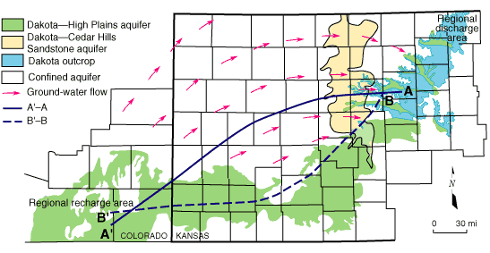
The Dakota aquifer system extends across much of the central North American continent from approximately the Arctic Circle in Canada to northeastern New Mexico and the Oklahoma panhandle and from the Rocky Mountains to western Iowa and Minnesota. The aquifer underlies approximately 40,000 square miles (103,600 square km) of the western two-thirds of Kansas (fig. 1).
Figure 1--Map showing the confined and unconfined regions of the Dakota aquifer in Kansas and regions of hydraulic connection with other aquifer systems. Arrows indicate the directions of ground-water flow through the confined Dakota aquifer from the regional recharge to the discharge area. The lines A'-A and B'-B show the trace of the cross sections in figs. 3 and 5, respectively.
The Dakota aquifer system consists of sandstone bodies in the Cheyenne Sandstone, Kiowa Formation, and Dakota Formation in Kansas (fig. 2). The sandstone bodies are encapsulated in shales that are a part of these geologic units. The shales, however, are not considered part of the aquifer. Not all of these geologic formations are present throughout the aquifer's extent. The combined thickness of these geologic units ranges up to more than 700 feet (213 m) in parts of west-central Kansas.
Figure 2--Geologic units of the Dakota Aquifer.
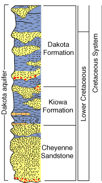
In western and parts of central Kansas, the Dakota aquifer system is separated into upper and lower aquifers by an aquitard within the Kiowa Formation. The upper Dakota aquifer consists of the sandstones in the Dakota Formation. The lower Dakota aquifer consists of sandstones in the lower part of the Kiowa Formation and Cheyenne Sandstone. Over much of central Kansas, this aquitard in the Kiowa is not present, and the upper and lower aquifer units can not be distinguished.
The total thickness of sandstone in the Dakota aquifer ranges from less than 5% to more than 50% of the combined thickness of the Dakota and Kiowa Formations and the Cheyenne Sandstone and varies dramatically even over distances of less than a few miles. Variations in the thickness of the sandstone are related to the way in which the sands were deposited. In Kansas, the sands were deposited in ancient rivers, deltas, and beaches along the eastern side of an inland seaway. The discontinuous sandstone bodies are lens shaped, rather than flat and continuous. Typically, the best sandstone aquifers are up to 100 feet (30 m) thick, 1.5 miles (2.4 km) wide, and 20 miles (32 km) or more long. Outcrops of these thick, alluvial sandstone bodies form the bluffs and canyons along the north shore of Kanopolis Reservoir in Ellsworth County and along the Saline River valley in the vicinity and upstream of Wilson Reservoir in Russell County.
Kansas Geological Survey, Public Outreach
bsawin@kgs.ku.edu
Web version April 1997
http://www.kgs.ku.edu/Publications/pic7/pic7_1.html