Kansas Geological Survey, Public Information Circular (PIC) 22
Prev. Page--Start of the Report || Next Page--Recharge Research
![]()
![]()
![]()
![]()
Kansas Geological Survey, Public Information Circular (PIC) 22
Prev. Page--Start of the Report ||
Next Page--Recharge Research
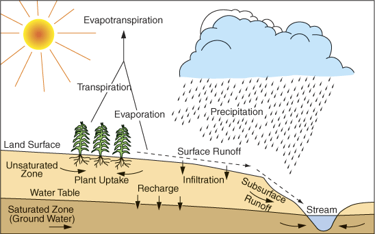
Climate: The amount of precipitation that falls on the earth's surface plays a major role in the amount of recharge (fig. 2). However, precipitation is not the only climatic factor affecting recharge. The timing and seasonal distribution of precipitation are also important. A certain amount of moisture build-up in the soil is necessary for ground-water recharge. Thus, early spring rains, when soils are at their wettest following snowmelt, are usually the most effective in recharging the aquifer. In addition to snowmelt, frequent rainfall, with relatively small evaporation and plant transpiration losses, builds up soil-moisture levels and thus enhances the recharge process. In the summer, short-duration, heavy rains or thunderstorms do not usually contribute to recharge. When the weather is hot and windy, plants need more water to grow and survive, causing them to remove water from the soil before it has a chance to replenish the aquifer. That hot and windy condition makes it more likely that water will evaporate before it has a chance to percolate deep into the soil. Because average annual precipitation is low in western Kansas (as little as 15 inches per year in some places) and much higher in eastern Kansas (more than 40 inches), recharge is generally considerably higher in eastern Kansas than in western Kansas.
Figure 2--Ground-water recharge in the hydrologic cycle.
Soils and Geology: To recharge an aquifer, water has to move through the root zone and down into the water table. Some types of soils, such as the sandier soils of central Kansas, allow water to move more quickly through the soil profile than other soils, such as those that are high in clay. The geologic make-up of an area also affects recharge. Water may reach the aquifer more quickly through fractures than through the interconnected space of porous materials.
Vegetation and Land Use: Types of vegetation and land-use practices also influence recharge. Mature plants have a greater ability to extract moisture from the soil than younger plants. Of the crops that are generally grown in Kansas, alfalfa (because it has deep roots and is harvested several times a year) extracts the most moisture from the soil, thus lessening recharge. Prairie grasses generally take up less moisture than alfalfa but more than other crops. Wheat, because its roots are shallow, takes up the least amount of water. One study in south-central Kansas (Sophocleous and McAllister, 1990) estimated that recharge was about 0.15 inches per year in areas planted to alfalfa, compared to 5.1 inches per year for wheat (average annual precipitation during the 1982-1983 study period was 21.62 inches).
Topography: For the most part, areas of relatively steep topography have lower rates of recharge. Water runs off steeper slopes more quickly with less infiltration into the ground, and thus produces less recharge than flatter areas where water has more time to soak into the ground.
Depth to Ground Water: In general, the deeper the aquifer, the less the recharge. When water has a greater distance to travel before reaching the water table, it is more likely to be captured by plant roots, absorbed by the soil, or blocked from the aquifer by a layer of clay or some other rock material. Thus, in parts of western Kansas, where the Ogallala portion of the High Plains aquifer is several hundred feet deep, water has greater travel times and recharge is low. By comparison, in parts of central Kansas, the water table is less than 20 feet deep and water moves from the surface to the aquifer much more quickly.
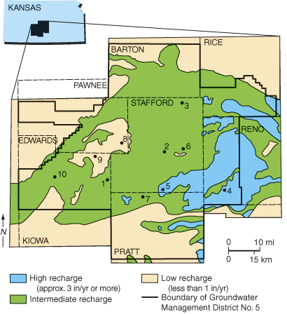
All the above-mentioned factors that control recharge can be mapped as separate overlays using Geographic Information Systems (GIS) technologies and combined to classify regions of higher and lower recharge. This was done, for example, in the Big Bend Groundwater Management District No. 5 in south-central Kansas, where maps of (1) average annual precipitation, (2) available water capacity of the soil (amount of water a soil can store in a form available for use by plants), (3) depth to water table, and (4) average springtime rainfall rate were combined to identify areas of high and low recharge as shown in fig. 3 (Sophocleous, 1992).
Figure 3--Recharge zonation for the Great Bend Prairie region of central Kansas. Numbers indicate monitoring sites (adapted from Sophocleous, 1992).
Prev. Page--Start of the Report || Next Page--Recharge Research
Kansas Geological Survey, Public Outreach
Web version August 15, 2003
http://www.kgs.ku.edu/Publications/pic22/pic22_2.html