Kansas Geological Survey, Public Information Circular (PIC) 21
Prev. Page--Salt Production
![]()
![]()
![]()
![]()
Kansas Geological Survey, Public Information Circular (PIC) 21
Prev. Page--Salt Production
Caverns in the salt beds of Kansas are also used for storing natural gas, natural gas liquids, and other hydrocarbons. Some caverns that are now used for hydrocarbon storage were originally created during salt mining; others were created by solution specifically for the storage of hydrocarbons. Salt caverns are used for storage because salt is highly impermeable, and salt beds in Kansas are thick and fairly predictable. In addition, large quantities of gas can be introduced into, and taken out of, salt caverns relatively quickly. Energy companies use salt caverns to store natural gas during times of low demand, then quickly move it out of caverns in the winter, during times of peak demand. Natural gas is also stored in depleted oil and natural gas fields in Kansas and other parts of the country, but moving gas into and out of these depleted fields takes much longer. A typical storage cavern in Kansas salt holds about 100,000 barrels, or 4.2 million gallons, of hydrocarbons, usually under pressure.
Because Kansas is in the central part of the U.S. and relatively close to major natural gas fields, a number of pipelines run through the state. These pipelines take advantage of hydrocarbon storage facilities in the salt in central Kansas. Hydrocarbons are stored in salt caverns in at least five other states in the U.S., but Kansas has more storage caverns in salt than any other state. Storage facilities were originally developed in Kansas in the early 1950's. Today hydrocarbons are stored at sites in Rice, Reno, McPherson, and Ellsworth counties. In January 2001, a rupture in a pipe in a natural-gas storage facility in Reno County was hypothesized to be the source of gas that led to a series of explosions and geysers in the city of Hutchinson. Gas may have moved from the facility, under the city, then to the surface through long-forgotten salt-solution wells. The Kansas Geological Survey worked with the city, the local utility, and the Kansas Department of Health and Environment to try to understand the movement of the gas and to locate abandoned solution wells.
In addition to being a resource, salt has created several environmental problems in the state. Particularly along the solution front in central Kansas, dissolved salt sometimes winds up in rivers, streams, marshes, and lakes. For example, salt in the bedrock beneath Saline and McPherson counties has been naturally dissolved and the brine has moved north and east into the aquifer adjacent to the Smoky Hill River, thus increasing salinity levels in the Smoky Hill. In Reno and Rice counties, saltwater produced during the early days of salt-solution mining has led to localized problems of increased salinity in the ground water. Salinity levels in other streams and marshes in Kansas are sometimes elevated, but that salinity is the result of natural saline contamination from salty aquifers and not from the salt mining near Hutchinson (see Why are the Quivira Marshes Salty?). Saltwater from dissolution of the Hutchinson Salt Member also discharges to overlying alluvial aquifers and into streams and the Arkansas River to the south in Sumner County.
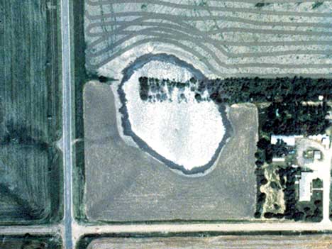
Salt dissolution, either natural or human-induced, is also responsible for surface subsidence areas (sinkholes) in Kansas (fig. 6). Salt layers in the subsurface are dissolved by water, creating underground void spaces. When the ceiling above those voids can no longer support the weight above, the rock layers collapse, causing subsidence at the surface. Natural sinkholes, such as Lake Inman in McPherson County, are common on the solution front along the eastern edge of the Hutchinson Salt Member. Human-induced subsidence areas are rare, but when they occur, they are usually attributed to salt mining or oil and gas operations. Sinkholes that suddenly collapse are called catastrophic sinkholes. Sinkholes that have formed gradually are visible along Interstate 70 at milepost 179, west of Russell in Russell County. This subsidence is probably related to an abandoned oil well. In Reno County, gradual subsidence is occurring at the intersection of U.S. Highway 50 and Victory Road, about 6 miles east of Hutchinson; it is probably the result of natural dissolution along the solution front.
Figure 6--Aerial photo of sinkhole in Ellsworth County.
Bayne, C. K., compiler, 1972, Supplemental areas for storage of radioactive wastes in Kansas: Kansas Geological Survey, Special Distribution Publication 60, 20 p.
Kansas Geological Survey, 2001, Gas Storage, USA--Hutchinson Response Project: http://www.kgs.ku.edu/Hydro/Hutch/GasStorage/index.html (Aug. 2008).
Hays, R., 1890, Notes on some Kansas salt marshes: Transactions of the Kansas Academy of Science, v. 12, p. 97-00.
Kansas Department of Health and Environment, 2001, Bureau of Water, Underground Injection Control: http://www.kdheks.gov/uic/index.html (AUg. 2008).
Kirk, M. Z., 1899, Kansas Salt; in, Annual Bulletin on Mineral Resources of Kansas for 1898, E. Haworth, ed.: The University Geological Survey of Kansas, p. 68-85.
Rauzi, S. L., 2002, Arizona has salt: Arizona Geology, v. 32, no. 1, p. 1-5.
Taft, R., 1946, Kansas and the nation's salt: Transactions of the Kansas Academy of Science, v. 49, no. 3, p. 223-272.
Thomas, R. L., and Gehle, R. M.,, 2000, A Brief History of Salt Cavern Use, Solution Mining Research Institute: http://www.solutionmining.org/ (Aug. 2008).
Tolsted, L. L., and Swineford, A., revised by Buchanan, R., 1986, Kansas Rocks and Minerals: Kansas Geological Survey, Educational Series 2, 60 p.
U.S. Geological Survey Minerals Information, 2000, Minerals Yearbook, The Mineral Industry of Kansas: http://minerals.usgs.gov/minerals/pubs/state/ks.html (Aug. 2008).
Watney, W. L., Berg, J. A., and Paul, S., 1988, Origin and Distribution of the Hutchinson Salt (Lower Leonardian) in Kansas; in, Permian Rocks of the Midcontinent, W. A. Morgan and J. A. Babcock, eds.: Midcontinent Society of Economic Paleontologists and Mineralogists, Special Publication 1, p. 113-135.
Why are the Quivira Salt Marshes Salty?
Kansas Geological Survey, Geology Extension
Web version July 2002
http://www.kgs.ku.edu/Publications/pic21/pic21_4.html