Kansas Geological Survey, Public Information Circular (PIC) 20
Prev. Page--How To Use the PLSS
![]()
![]()
![]()
![]()
Kansas Geological Survey, Public Information Circular (PIC) 20
Prev. Page--How To Use the PLSS
In Kansas, not all townships and sections are perfectly square. Some townships have fewer than 36 sections, and some sections contain fewer than 640 acres, particularly along the east, south, and west borders of Kansas where the survey terminated (fig. 1). Because of the way sections were surveyed (beginning in the southeast corner of the townships), sections along the west and north lines of the townships have accommodated any adjustments that were necessary to fit within the previously surveyed township and range lines. Another source of irregularity results from the misplacement, in 1855, of the Sixth Principal Meridian 60 miles west of the Missouri River, instead of the prescribed 108 miles. By the time the meridian was reestablished at its proper location, extensive surveying had been done using the incorrectly established meridian, and thus it was preserved as a guide meridian (range line) without offsets. The major consequence of this misstep is that the sections on the west edges of all townships in Range 8 East are wider than usual, most notably at the Kansas-Oklahoma border, where sections are more than 13,000 feet wide.
Other adjustments sometimes necessitated irregular sections elsewhere within a township. In some cases, the shapes of sections may be distorted, particularly where section lines change direction at a quarter corner (fig. 4). Navigable streams and lakes larger than 25 acres were excluded from the survey, resulting in partial sections in some places next to such bodies of water. Along the Missouri River, some areas that were originally surveyed in the Missouri system now lie within Kansas due to shifts in the course of the river. County surveyors in some of the affected river counties are currently extending the Kansas survey lines into those areas.
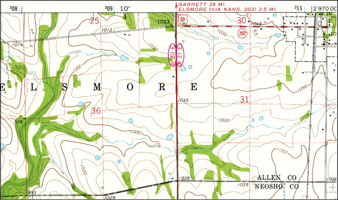
Figure 4--Topographic map showing an example in which section boundaries were distorted to allow survey lines to meet across the guide meridian between Range 20 East and Range 21 East in southern Allen County (from USGS Stark, Kansas, 7.5 min. quadrangle).
Land within the 1856 boundary of Fort Riley was not included within the original survey, and most of these lands still have not been surveyed within the PLSS. A relatively small area along the south and west boundaries of Fort Riley, called the Republican River Bridge Company Lands, also was not included in the original survey, but was later surveyed according to legislation passed by Congress in 1869 that provided for "special section" numbers (1 to 13). These sections were surveyed in a random fashion without regard to existing section numbers or lines within the township. As a consequence, within Township 11 South, Range 5 East, there are not only sections or partial sections 1 to 13, but also partial "special sections" 1 to 13.
White, C. A., 1982, A History of the Rectangular Survey System: U.S. Department of the Interior, Bureau of Land Management, 774 p.
Prev. Page--How To Use the PLSS
Kansas Geological Survey, Public Outreach
Web version January 2002
http://www.kgs.ku.edu/Publications/pic20/pic20_4.html