Kansas Geological Survey, Public Information Circular (PIC) 20
Prev. Page--Start of the Report || Next Page--How To Use the PLSS
![]()
![]()
![]()
![]()
Kansas Geological Survey, Public Information Circular (PIC) 20
Prev. Page--Start of the Report ||
Next Page--How To Use the PLSS
A township is a basic unit of land within the PLSS. Normally, townships are approximately 6 miles on a side. They are bounded on the north and south by township lines and on the east and west by range lines. Townships are designated by both a township and a range number. In Kansas, the townships are numbered 1 to 35 sequentially from the baseline at approximately 40° North latitude (the state line bordering Nebraska) southward to the Oklahoma border (fig. 1). Ranges are numbered east and west from the Sixth Principal Meridian--the east ranges are numbered from 1 to 25 to the Missouri border, and the west ranges from 1 to 43 to the Colorado border. Thus, for example, the first township east of the principal meridian and next to the Nebraska border is Township 1 South, Range 1 East (T. 1 S., R. 1 E.), whereas the one just west of the principal meridian is T. 1 S., R. 1 W. The township in the southeast corner of the state is T. 35 S., R. 25 E., and the one in the southwest corner of the state is T. 35 S., R. 43 W.
Because the surface of the earth is curved, parallels of longitude, and thus north-south survey meridians in the U.S., converge toward the north. Consequently, the range lines must be offset periodically to preserve the 6-mile by 6-mile configuration of the townships; otherwise, townships would be considerably narrower in the northern part of the state than in the southern part. Such offsets were set up along standard parallels, or correction lines, that were established every 30 miles south of the baseline. This is most easily seen in the northwestern part of the state, where east-west county lines coincide with the correction lines, and the north-south range lines are offset across those lines (e.g., across the east-west county line between Cheyenne and Sherman counties) (fig. 1).
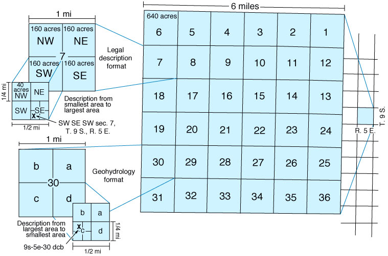
Townships are divided into 36 sections of approximately 1 square mile or 640 acres each (fig. 2). Numbering of the sections begins in the northeast corner of the township and proceeds back and forth, east and west, until the last section, Section 36, is reached in the southeast corner of the township. Sections, in turn, can be divided into smaller units, by quarters. For example, one quarter of a section is 160 acres, one quarter of a quarter is 40 acres, and one quarter of a quarter of a quarter is 10 acres, and so forth. For example, the 10-acre parcel shown on fig. 2 is designated as the southwest quarter of the southeast quarter of the southwest quarter of Section 7, Township 9 South, Range 5 East, which is usually abbreviated as SW1/4 SE1/4 SW1/4 sec. 7, T. 9 S., R. 5 E. or SW SE SW sec. 7, T. 9 S., R. 5 E. This may be further abbreviated as SW SE SW 7-9S-5E. Note that these descriptions begin with the smallest area (a 10-acre parcel) and progress to the largest area (a township).
An Alternative Method--Geohydrologists at the U.S. Geological Survey use a modification of the PLSS to identify parcels of land. Their method is used in numerous hydrological reports and databases that are available to the public in print or on the Kansas Geological Survey web site http://www.kgs.ku.edu/. According to this method, quarter designations are replaced by the letters a, b, c, and d in a counterclockwise manner, starting in the northeast corner (fig. 2). Additionally, the descriptions are listed from the largest to the smallest area, just the opposite of the standard method. For example, a location described as NW SW SE sec. 30, T. 9 S., R. 5 E. in the standard method becomes 9S-5E-30 dcb in the geohydrologists' method. Note: this alternate method is not to be used for official legal descriptions.
Figure 2--Diagram illustrating section numbering and method of assigning legal land descriptions under the PLSS. The section shown in the upper left of the figure is described as Section 7, Township 9 South, Range 5 East, which is usually abbreviated as sec. 7, T. 9 S., R. 5 E. The method for subdividing sections by quarters is also shown, as well as the legal description. The alternative, geohydrology format is illustrated on Section 30, in the lower left of the figure.
Prev. Page--Start of the Report || Next Page--How To Use the PLSS
Kansas Geological Survey, Public Outreach
Web version January 2002
http://www.kgs.ku.edu/Publications/pic20/pic20_2.html