![]()
![]()
![]()
Kansas Geological Survey, Public Information Circular (PIC) 30
A complete version of this PIC is available as a pdf document.
Catherine S. Evans
Kansas Geological Survey
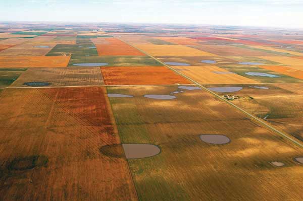
Mostly small, obscure, and frequently dry, the tens of thousands of playas scattered across western Kansas and the surrounding states (fig. 1) have, nevertheless, collectively become recognized as one of the most vital water resources in the High Plains. What the region's playas lack in size they make up for in quantity. Individually, they are far outsized by more familiar desert playas. California's Rogers Dry Lake at Edwards Air Force Base covers 44 square miles and has been used to land space shuttles. Kansas' largest playa, in Finney County, covers less than a square mile (Bowen et al., in press). Overall, however, the High Plains region of the southern Great Plains has the highest concentration of playas in the world.
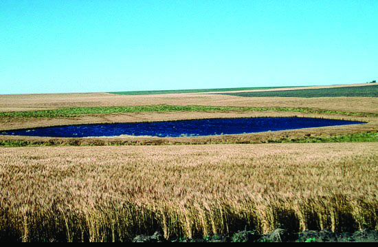
Figure 1--Playa lakes in Scott County, Kansas (photograph by William C. Johnson).
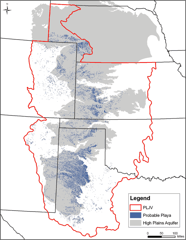
Together these playas provide thousands of important, if transient, wetland environments as well as much-needed ground-water recharge in a region where precipitation averages less than 20 inches a year and can evaporate up to five times faster than it soaks in (Gurdak and Roe, 2009). Most of the High Plains playas are dispersed throughout an area ranging north from western Texas and eastern New Mexico into Oklahoma, Kansas, Colorado, and Nebraska (fig. 2), and overlie the extensive High Plains aquifer, which includes the Ogallala aquifer.
Figure 2--Playa distribution within Playa Lakes Joint Venture (PLJV) boundaries and the High Plains aquifer. PLJV is a nonprofit partnership that promotes playa conservation. Playas in southeastern Wyoming not shown because not within PLJV boundaries (used with permission of PLJV; map by Megan McLachlan).
Also called lagoons, buffalo wallows, or mud holes, the naturally occurring playas are relatively round, shallow depressions lined with clay-rich soils that differ in composition from surrounding soils. In their natural state, playas' sole sources of water are precipitation and runoff, and during arid periods most eventually dry up. Yet following times of abundant precipitation, playas in the region retain water much longer than the adjoining semiarid, shortgrass-prairie, and agricultural lands. Wet playas rejuvenate dormant wetland vegetation that supports a much greater variety of animal life than the adjacent habitats. Water captured by playas also seeps down into the underlying High Plains aquifer.
More than 70% of playas in the High Plains have been modified in some way since settlement started in the late-nineteenth century (PLJV, 2007). Many have been cultivated or altered for such uses as storage for feedlot runoff, tailwater pits for irrigation, grazing and watering livestock, and landfills. To lessen the impact of such practices, Federal and State programs have been developed to help landowners manage playas and other wetlands. Scientists also continue to study playas to better understand the long-term effects that human activities have on the region's ecology and water supply.
Sometimes confused with the glacially formed prairie potholes found farther north, High Plains playas are unique ephemeral pools whose origin and age are somewhat of a mystery. (As is the selection of their name--Spanish for "beach" or "shore.") Many theories have been proposed that attribute their formation to subsidence, wind, water erosion, surface irregularities, animal activities, climatic influences, irregular soil formation, or geomorphic, hydrochemical, or biologic processes (Smith, 2003; Gurdak and Roe, 2009). Most scientists now agree that playas were created by some combination of these.
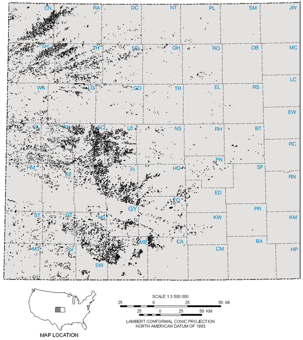
The greatest concentration of playas is found in the Llano Estacado of western Texas and eastern New Mexico, the largest plateau in North America. To the north, the density of playas is also substantial in the Oklahoma panhandle, western Kansas, and eastern Colorado. By the early 21st century, varied estimates put the number of High Plains playas between 25,000 and 60,000. These estimates included up to 10,000 in Kansas. However, University of Kansas (KU) researchers recently identified more than 22,000 in Kansas using tools such as high-resolution aerial imagery, digital raster graphics, and soil data (fig. 3). Their inventory includes many small playas previously overlooked (Bowen et al., in press).
Figure 3--Distribution of the more than 22,000 playas in Kansas (created from data in Johnson et al., 2009; modified from map by John Dunham, Kansas Geological Survey).
Each self-contained playa has its own watershed. Fed only by precipitation and runoff, playas also have no drainage systems. Unless water is removed for irrigation or other human activities, all water entering a playa leaves through evapotranspiration or infiltrates the ground.
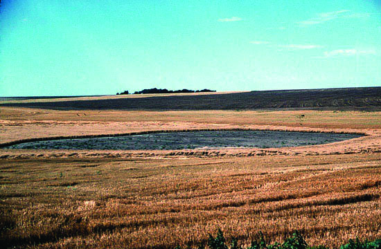
The wet-dry cycle of each playa varies widely with the weather, which dictates surface-water levels. Playas may remain dry for years during a drought or fill quickly and hold water for weeks, months, even years when precipitation is average to high (fig. 4). Evaporation rates are regulated by temperature and humidity.
Figure 4--Cheyenne County, Kansas, playa during a dry (top) and wet (bottom) period (photographs by Rolfe Mandel).
In 1877 a traveler to the Llano Estacado recorded how fluctuations in weather transformed playas: "[In late June] so tremendous an amount of water fell . . . that it had filled the depressions to overflowing; . . . in early July, we could see the outside water-line by the buffalo-chips and grass-blades that made a drift-line around the flood margins; but absorption and evaporation had caused the waters to recede until they were confined in the lower basins. One of these yet had a surface of about ten acres when we found it" (Cook, 1967).
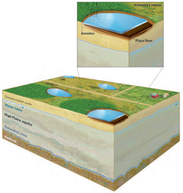
Playa characteristics include a clayey floor, which swells when wet and shrinks and cracks when dry, and an annulus--the sloped surface at a playa's margin. Interplaya regions are the upland, non-wetland areas (fig. 5; Gurdak and Roe, 2009). Some larger playas have lunettes, dune-like, crescent-shaped ridges to the southeast formed by windblown material. The lunettes preserve a record of climate change and, in some cases, archeological artifacts. In Kansas, about 4% of the playas have lunettes.
Figure 5--Playa features include a floor and annulus (sloped surface at the playa margin). The interplaya region between playas includes the watersheds (from Gurdak and Roe, 2009).
Hydric soils that line the playa basins have a high content of expansive clay, which helps retain the water to create wetland conditions. When the upper layer of soil in the basin is wet during a growing season, anaerobic conditions develop as organisms consume the oxygen in the soil. Most plants cannot survive without oxygen so the ones that can--hydrophytes such as marsh grasses--help mark a playa's location (EPA, 2009).
Although soils, vegetation, and hydrologic conditions are key factors in playa identification, the detection process is not always clear-cut. A playa may show no evidence of hydrophytic plants and playa hydrology during a dry spell and then suddenly teem with wetland plants and wildlife following torrential rains. Playas modified through cultivation and other human activities also may be difficult to identify because changes can greatly alter wetland soil and vegetation.
Dynamic features in the landscape, playas formed on the High Plains of Kansas as early as 9,500 years ago. Many partially or completely filled with sedimentation until a period of aridity set in about 7,000 years ago, and intensive wind erosion deepened playa basins. This erosion event ended about 4,500 years ago and was followed by the return of playa soil formation and sedimentation, which continues today (Mandel, 2006).
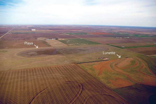
Archeological evidence in western Kansas shows people were using playas as a life-sustaining resource at least 9,000 years ago. In Stanton County, a deeply buried bison bonebed, exposed where Bear Creek cut into the edge of a playa basin, contained the remains of at least seven bison along with flakes, projectile points, and a small hearth area probably used for butchering and processing activities. Some of the bison limbs were folded together, suggesting the animals collapsed after being hunted down in the playa (Mandel and Hofman, 2003). In Lane County, the Ehmke Playa site (fig. 6) yielded projectile points, flakes, burned rock, mussel shells, and bone fragments from bison, mammoths, turtles, and birds. Artifacts were found on the southeast side of the lunette adjacent to the playa, suggesting the crescent-shaped rise was used as shelter from the northwesterly winds (Campbell et al., 2007; William C. Johnson, personal communication, 2009).
Figure 6--Ehmke playa, Lane County, Kansas, during a dry period. The lunette, a mound created from windblown sediment, has provided archeological artifacts and physical evidence of past climate change (photograph by William C. Johnson).
Playas in the High Plains vary in size from less than a tenth of an acre to more than a square mile (640 acres). While the largest in Kansas is 465 acres (Finney County), only 403, or 2%, of the state's playas are greater than 25 acres, and just two are larger than 250 acres. More than 80% of the state's playas are less than 5 acres (Bowen et al., in press). No matter what their surface area, most playa basins are 3 feet (1 m) deep or less.
Altogether, the state's approximately 22,045 playas occupy more than 81,000 acres in 43 western Kansas counties (fig. 3). Scott, Thomas, Lane, Cheyenne, Finney, and Sherman counties have the most playas per county, with numbers ranging from 2,116 to 1,373 each. More than half are in the central portion (Scott, Lane, and Finney counties). Thomas, Cheyenne, and Sherman in the northwest have a combined 5,404 playas, and Meade, Gray, Haskell, and Wichita all have more than 1,000 each. In total acreage, Finney and Meade counties lead with about 8,036 and 6,921 acres of playas, respectively (Bowen et al., in press).
Almost all playas in Kansas and the surrounding states are on private property and not accessible without landowner permission. Three in Ford County, however, are on public land managed by the Kansas Department of Wildlife and Parks (KDWP) for wildlife and hunting. Wild Turkey Playa Wildlife Area 7 miles (11 km) west of Dodge City covers approximately 50 acres of playa wetland and 107 acres of native grass. Stein Playa Wildlife Area 7 miles (11 km) southwest of Spearville has 73 playa wetland acres and 44 native grass acres. Restoration of the 700-acre Herron Playa Wildlife Area 4.5 miles (7 km) southwest of Spearville was completed in 2003. That area includes 160 playa wetland acres, 360 native grass acres, and 180 cropland acres (KDWP, 2010).
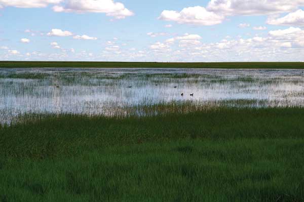
In a region where surface water is in short supply, playas are the main source of water for hundreds of plant and animal species, both year-round and migratory (fig. 7). At least 340 plant, 185 bird, 37 mammal, and 13 amphibian species as well as 124 types of aquatic invertebrates have been associated with southern Great Plains playa environments (Haukos and Smith, 2003). Because most plant and animal species in the High Plains depend in some way on the playas, the region's diversity would be severely limited without them.
In Meade County alone, 168 species of birds have been counted in playa settings. A variety, from the Golden Eagle and Great Blue Heron to the Indigo Bunting and American Avocet, are known to nest in the county's playas, while others, such as the Mallard, Sandhill Crane, and Canada Geese, stopover or winter there (Flowers, 1996). Other wildlife found in playa wetlands range from invertebrate dragonfly larvae to toads, turtles, rabbits, raccoons, bats, and deer. No fish occur naturally in playas.
Figure 7--Wetland vegetation and birds in the Ehmke playa, Lane County, Kansas, during a wet period (photograph by William C. Johnson).
Plants commonly associated with a playa wetland include spike rushes, toothcup, umbrella sedge, and western water clover, and are sometimes found even after a playa has been disturbed by agricultural practices (Kindscher et al., 1996). Annuals and short-lived perennials, with long-lived seeds or hardy underground structures, survive best (Smith, 2003).
The plant and animal communities in the numerous playas across the High Plains vary from one another depending on the size, depth, and other characteristics of individual playas. Variations also are caused by local wet-dry cycles. Two similar playas only a short distance apart may contain very different plant and animal species at a given moment due to highly localized precipitation events.
Even a single playa can appear different from one day to the next because dormant communities emerge quickly with hydration. Many seeds, invertebrates, and amphibians have adapted to the unpredictability of playa cycles and can remain dormant in sediments for years (Smith, 2003). An invertebrate fairy shrimp egg, for example, can hatch under favorable hydrologic conditions and complete its life cycle in about 21 days after surviving in playa soil for 20 years (Kuiper, 2003).
Playas are an important source of recharge for the extensive High Plains aquifer (fig. 2), which includes the Ogallala aquifer and provides virtually all municipal, industrial, and irrigation water for western Kansas and parts of seven other states. Although some early studies and models predicted that playa basins were impermeable and all water they stored eventually evaporated, current evidence shows that water infiltrates down through basin cracks or percolates around the edges to help replenish the aquifer. How much water from playas as a whole reaches the aquifer, and how much is lost to evapotranspiration, is still being investigated.
According to a comprehensive review of published research on the connection between playas and the High Plains aquifer, most studies indicate recharge rates are significantly higher beneath playas than in the surrounding nonplaya environment (Gurdak and Roe, 2009). Recharge rates, however, do vary from playa to playa. Characteristics that affect recharge include playa size and depth, size of a playa's drainage area, depth of the clay that lines the basin, depth of sediment that has accumulated in the basin, subsurface sediment between the playa and the aquifer, and depth of the water table. Long- and short-term climate fluctuations and land-use practices are among the influences that determine or alter these characteristics.
As the High Plains environment of the late-19th and 20th centuries evolved from a semi-arid and shortgrass prairie into a mainly agricultural environment, playas became an irritant for many farmers who regularly lost cropland during wet periods. Of the 70% or more playas that have been modified from their natural state, many have been tilled or intentionally filled to prevent occasional flooding that can cause crop failure. Others have been used for grazing or storage of irrigation waters, feedlot runoff, and treated wastewater, or altered by road construction and urban development. Invasive non-native plant species, intentionally or unintentionally introduced into the region, also have encroached on wetland vegetation (PLJV, 2007; Haukos and Smith, 2003).
Sedimentation of the playa basins associated with erosion following the removal of protective native plants is the greatest threat to the future of playas and the vital functions they perform. As has become increasingly apparent in recent years, playas provide habitat for a majority of the region's plant and animal species and play an important role in replenishing the High Plains' water supply. Non-playa soil and other sediments, carried in with runoff, fill the basins and bury the clay soils needed to create wetland environments and recharge the underlying aquifer. Contaminants in the runoff can also lower ground-water quality (Gurdak and Roe, 2009; PLJV, 2007).
The Federal government enacted several regulations to manage the modification of "waters of the United States," including wetlands. A 2001 U.S. Supreme Court ruling, however, narrowed the definition of "waters of the United States," and few playas now fit the criteria due to their small size and ephemeral nature (Haukos and Smith, 2003). Most playas, therefore, are not covered by Federal wetland regulations, and none of the High Plains states has regulations protecting playas. Landowners with playa wetlands, nevertheless, are eligible to participate in several government programs that promote the voluntary conservation or restoration of water bodies (KAWS, 2010; KDWP, 2010).
Several nonprofit conservation and agricultural organizations, government agencies, and universities in the region are exploring ways to protect, conserve, and restore playas that are beneficial to both the environment and landowners. Among them are the KU researchers who inventoried the Kansas playas and are also examining the health and geologic structure of the state's playas, and the Playa Lakes Joint Venture (PLJV; fig. 2) and its partners.
The PLJV is a nonprofit partnership of more than 50 Federal and State wildlife and natural resources agencies, environmental groups, corporations, and landowners who promote the conservation of playas and other wildlife habitats in the High Plains. The PLJV region covers portions of Texas, New Mexico, Oklahoma, Kansas, Colorado, and Nebraska (PLJV, 2007) and includes the following Kansas organizations and agencies:
Because almost all of the High Plains playas are on privately owned land in sparsely populated areas, conservation efforts are complex. Although preservation is rarely mandatory, the voluntary government programs provide farmers incentives to preserve and restore playas, which are often only marginal as cropland even in the best of years.
Landowners are being encouraged to establish native-prairie grassland buffers to help restore cultivated and modified playas. Buffers around the playas may not only help restore wetland conditions that attract wildlife, they filter out sediment, fertilizer, and pesticides from runoff that eventually percolates down through the playa basins into the High Plains aquifer (PLJV, 2007).
Anaerobic: Lacking oxygen.
Aquifer: A saturated formation of rock or unconsolidated materials that holds ground water in pore spaces and is capable of yielding large amounts of water through such outlets as springs, streams, and wells.
Bonebed: A sedimentary layer, usually a thin bed of sandstone, limestone, or gravel, in which fossil bones or bone fragments are abundant.
Evapotranspiration: The sum of water vapor transported into the atmosphere through evaporation (from land and water) and transpiration (from plants).
Geomorphic: Pertaining to the surface features of the earth and the processes that create them.
Hydric Soils: Soils that are periodically wet long enough to produce aneorobic, or oxygen-deprived, conditions.
Hydrophytes: Aquatic plants that require a large amount of water to grow.
Lunette: A broad and low crescent-shaped mound created from windblown sediment.
Recharge: The process of adding water to an aquifer naturally, through infiltration of precipitation and runoff, or artificially. Also, the amount of water added to an aquifer.
Runoff: Drainage or flood discharge, usually from precipitation, that moves on the surface and often enters rivers, lakes, and other bodies of water.
Sedimentation: The deposition or build-up of sediments, including gravel, sand, silt, and clay, by such forces as wind and water.
Watershed: An area of land from which all surface water drains toward a common body of water, such as a river or playa. Some watersheds, especially for large rivers, may extend a great distance while playa watersheds are relatively small.
Bowen, M. W., Johnson, W. C., Egbert, S. L., and Klopfenstein, S. T., in press, New methods for identifying and mapping playa lakes on the High Plains, Kansas, USA: Wetlands.
Campbell, J. S., Johnson, W. C., and Bowen, M. W., 2007, Ehmke playa; Relationship between playas of the central High Plains and potential Paleoindian archaeology: Current Research in the Pleistocene, v. 24, p. 194-195.
Cook, J. R., 1967, The border and the buffalo--An untold story of the Southwest plains: New York, Citadel Press, 454 p.
EPA, 2009, Section 404 of the Clean Water Act--How wetlands are defined and identified: U.S. Environmental Protection Agency, http://www.epa.gov/owow/wetlands/facts/fact11.html (verified 10/09).
Flowers, T. L., 1996, Classification and occurrence of the birds of playa lakes of Meade County, Kansas: Kansas Ornithological Society Bulletin, v. 47, no. 2, p. 21-28, http://www.ksbirds.org/kos/bulletin/Vol56No4.pdf (Acrobat PDF file, verified 10/09).
Gurdak, J. J., and Roe, C. D., 2009, Recharge and chemistry beneath playas of the High Plains aquifer--A literature review and synthesis: U.S. Geological Survey, Circular 1333, 39 p., http://pubs.usgs.gov/circ/1333 (verified 10/09).
Haukos, D. A., and Smith, L. M., 2003, Past and future impacts of wetland regulations on playa ecology in the southern Great Plains: Wetlands, v. 23, no. 3, p. 577-589.
Johnson, W. C., Bowen, M. W., and Klopfenstein, S. T., 2009, Data high-resolution database of playa basin distribution on the High Plains of Kansas: Kansas GIS, http://www.kansasgis.org/catalog/catalog.cfm.
KAWS, 2010, Playa lakes in Kansas: Kansas Alliance for Wetlands and Streams, http://www.kaws.org/playa-lakes-Kansas (verified 1/10).
KDWP, 2010, KDWP website: Kansas Department of Wildlife and Parks, http://www.kdwp.state.ks.us (verified 1/10).
Kuiper, K., 2003, Observations of drought and wildlife: Natural Resources Conservation Service (NRCS), http://www.ks.nrcs.usda.gov/news/coneds03/drought03.html (verified 10/09).
Kindscher, K., Wilson, S., Fraser, A., and Lauver, C., 1996, Vegetation of western Kansas playa lakes--1993-95: Kansas Biological Survey, Report No. 70, 37 p.
Mandel, R. D., 2006, The effects of Late Quaternary landscape evolution on the archaeology of Kansas; in, Kansas Archaeology, R. J. Hoard and W. E. Banks, eds.: University Press of Kansas, p. 28-45.
Mandel, R. D., and Hofman, J. L., 2003, Geoarchaeological investigations at the Winger site--A late Paleoindian bison bonebed in southwestern Kansas, U.S.A.: Geoarchaeology, v. 18, no. 1, p. 129-144.
PLJV, 2007, PLJV web site: Playa Lakes Joint Venture, http://www.pljv.org (verified 10/09).
Smith, L. M., 2003, Playas of the Great Plains; Austin, University of Texas Press, 257 p.
![]()
![]()
![]()
Kansas Geological Survey, Public Outreach
Comments to webadmin@kgs.ku.edu
Web version Feb. 2010
http://www.kgs.ku.edu/Publications/PIC/pic30.html