Petroleum: a primer for Kansas, Page 9 of 15
Prev Page--Maps ||
Next Page--Geophysical Exploration
The surface geologic map of Kansas shows a relatively simple pattern of bedrock strata cropping out at the Earth's surface (fig. 12). Paleozoic rocks dip very gently to the west and northwest from the structurally high Ozark dome centered in southeastern Missouri and north-central Arkansas. The oldest rocks are Mississippian limestones that occur in the most southeastern comer of the state. Broadly curved bands of Pennsylvanian and then Permian strata overlie Mississippian rocks and are exposed over the eastern third of Kansas. Sedimentary rocks of Cretaceous and Tertiary age blanket the Paleozoic rocks in western Kansas. This simplistic surface geology masks much more complex relationships known to occur deep underground from examination of drill holes and geophysical studies. The following discussion should be regarded as only a thumbnail sketch of the petroleum geology of Kansas. Detailed descriptions and discussions would fill a library. Summary accounts have already produced several books. A good example is Stratigraphic and spatial distribution of oil and gas production in Kansas by K. D. Newell et al. published by the Kansas Geological Survey in 1987 as Subsurface Geology Series 9.
Figure 12--A highly generalized geologic map of Kansas, showing area where rocks of different ages are exposed at the surface. The cross section at the bottom of the illustration shows an interpretion of rock layers at considerable depths beneath Interstate 70.
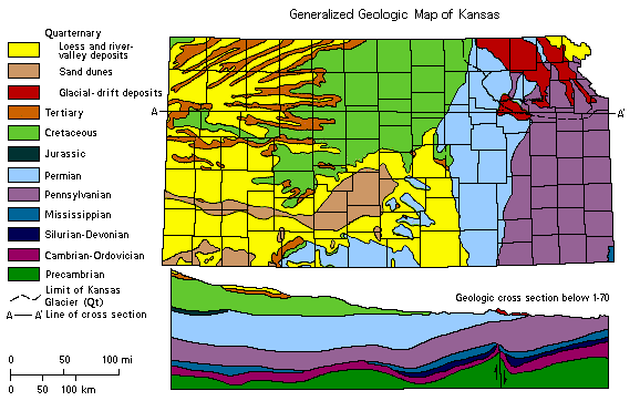
Figure 13--Map showing the relative locations of basins and uplifts deep beneath the surface of Kansas. These large structures are discussed in the text.
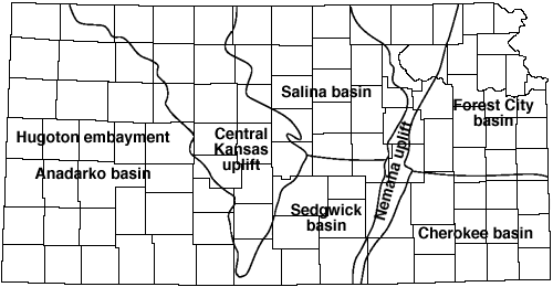
Figure 14--Diagram showing the sequence and age of rock strata found at and beneath the surface of Kansas. The naure of these rock layers is discussed in the text.
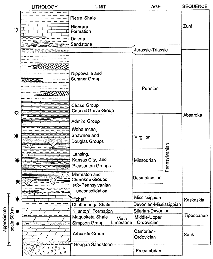
Sea level dropped and uplift of the region began after the sequence was deposited. Erosion began stripping the deposits from the higher lands, especially on the Chautauqua arch in southeastern Kansas and large parts of the Central Kansas uplift. Petroleum accumulation has been notable where these broadly upturned and beveled strata are covered by younger rocks at the overlying erosional unconformity. Accumulation is focused along the unconformity because: 1) the porosity of the limestones is greater along the weathered surface, 2) the unconformity terminates the porous limestone against nonporous rock, and 3) the unconformity apparently acts as a porous carrier of petroleum to the site of accumulation.
Shales of the Simpson Group contain an abundance of oil-prone organic matter. These shales have generated much of the oil produced from reservoirs in northeastern, central, and south-central Kansas.
A series of moderately thick limestones follows the Chattanooga Shale. The limestones accumulated on a broad, tropical, shallow marine shelf that extended across much of the United States. Mississippian limestones are divided into several formations which reflect changing depositional settings afforded by minor changes in sea level. These units provide many opportunities for oil and gas accumulation amounting to more than 20% of the original oil in place in Kansas. Later uplift and concomitant lowering of sea level led to tilting and erosion of these deposits. Notably, the Mississippian was removed over the Central Kansas uplift Prolific oil and gas fields were produced from adjoining flanks along belts or fairways where upturned and beveled Mississippian carbonates intersect the overlying unconformity at the top of the Kaskaskia Sequence. Oil apparently filled these reservoirs as it migrated along the unconformity surface.
Mississippian limestones contain abundant chert in southern Kansas. As these limestones weathered along the unconformity, a residual chert, called "chat," was produced. The chat is thickest along the southern flanks of the Central Kansas uplift bordering an area where the Mississippian strata were removed.
By Early Pennsylvanian time, erosion was stripping the older rocks from parts of the uplifts, permitting Pennsylvanian rocks to eventually rest directly on the upturned eroded edges of all older formations. Upper Pennsylvanian strata rest directly on the Precambrian surface in local areas on the Central Kansas and Nemaha uplifts. Then the entire region began subsiding, but the basins were sagging much faster than the faulted uplifts. Sedimentary rocks of Middle and Late Pennsylvanian and Early Permian age (Absaroka Sequence) are much thicker in the basins and thicken southward as well. As the regional basins were developing, individual structures on the uplifts were being jostled about, causing variations in depositional patterns. Complex structural and stratigraphic traps resulted.
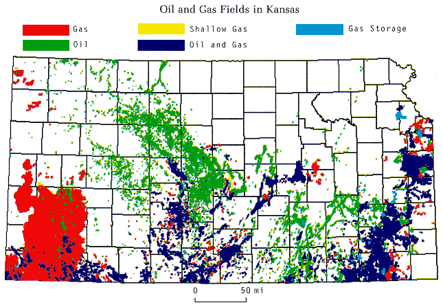
Early Pennsylvanian through Early Permian time was a period of great structural unrest, apparently brought on by collision between North American and South American-African continental plates. The situation was greatly complicated by simultaneous cycles of fluctuating sea levels, caused by episodes of continental glaciation in the polar regions. Sea levels rose and fell repeatedly; each time the shoreline would migrate inland several hundred miles, only to fall back during times of lowering sea level. Although each cycle of sedimentary rocks can be traced over thousands of square miles in the subsurface, variations in sedimentary facies caused by shorelines wandering about over growing faults and folds created untold hundreds of stratigraphic and structural traps. Many of these are found on the Central Kansas uplift, one of the most densely drilled targets in North America, but others are scattered over central and western parts of the state. Some of the most prolific reservoirs occur in the Lansing-Kansas City groups of Upper Pennsylvanian age. The Hugoton gas field, the largest accumulation of natural gas in North America, produces from Lower Permian cyclical dolomites in the Hugoton embayment of southwestern Kansas.
Rocks of Cretaceous age rest directly on Permian strata over most of the state. Triassic red beds are found only in a tiny area of southwestern Kansas, and the latest Jurassic rocks are known to occur in northwestern Kansas. Otherwise there are no rocks to represent the two geologic periods in the state. Chalks of Cretaceous age produce a little gas in northwestemmost Kansas.
Prev Page--Maps || Next Page--Geophysical Exploration