Petroleum: a primer for Kansas, Page 7 of 15
Prev Page--Exploration ||
Next Page--Maps
When a hole reaches its projected depth ("total depth"), geophysical logs are run in the hole to measure different properties of the rocks encountered. "Electric logs" measure naturally existing electrical currents and how the rocks transmit induced electrical currents. These logs detect porous zones and the nature of the contained fluids. Saltwater is a good conductor of electricity, while freshwater and hydrocarbons are not, thus the presence of saltwater (most deep underground waters are saline) can be determined and distinguished from petroleum. Oil-field waters in Kansas are highly variable in salinity, ranging from near freshwater to concentrated brines.
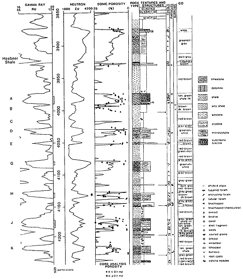
"Gamma ray-neutron logs" are records of the presence of naturally occurring radioactive minerals, even in minute quantities and show how the rocks respond to induced radioactive particles (fig. 9). Shale is more radioactive than sandstone or limestone and is thus distinguishable from them. When the rock is bombarded with neutrons, any hydrogen present in the rocks absorbs the radioactive particles. As any naturally occurring fluids, either hydrocarbons or waters, contain hydrogen, their presence is indicated and an indirect measurement of the rock porosity is recorded.
Figure 9--Well logs, such as gamma ray-neutron and sonic logs, are recorded on strip graphs that are keyed to depths in the well. These logs can be used to determine rock types at given depths, and to indicate zones of porous tock. This is an actual example of combined well logs and rock data from a well drilled in Cahoj field, Rawlins County, Kansas. A larger version of this figure is available.
Many other types of logs are occasionally run in wells, and new types are devised continually. These, however, are the most commonly run geophysical logs. "Subsurface geologists" use any or all of these data to determine exactly what rocks were drilled and to decide where to drill the next hole. They compare the logs of one well to others drilled in the vicinity (correlation) to determine the structure of the rock layers, as well as thickness and sedimentary-rock types present in each individual layer. From these data, maps are drawn.
Prev Page--Exploration || Next Page--Maps