Petroleum: a primer for Kansas, Page 5 of 15
Prev Page--Layered Rocks ||
Next Page--Exploration
Synclines are the opposite of anticlines. A syncline is a downfold, usually occurring between two anticlines. Every upfold on our wrinkled rug or sheet of paper has one or two adjacent downfolds. Synclines, like their associated structures the anticlines, are elongate, perhaps extending for many miles. More or less circular depressions in the layered rocks are called "basins," but that term is usually reserved for very large depressions, tens or hundreds of miles wide, in the Earth’s crust. Such large basins are natural centers for thick accumulations of sedimentary rocks. Unlike anticlines, synclines only form structural traps for petroleum when the depressed strata occur above the water table in dry rocks and oil gathers in the bottom by gravity flow. Such synclinal oil fields are rare, although the first oil produced west of the Mississippi River was from a syncline at the Florence-Canyon City field in central Colorado (fig. 5).
Figure 5--Layered rocks of the Earth's crust are often folded when the crust is shortened by intense compressional forces. Upfolds are called "anticlines," downfolds are called "synclines," and broad downfolded area are known as "basins."
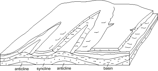
Figure 6a--Fractures in the Earth's crust along which movement has taken place are called "faults." Where one side of the fault is dropped down by gravity relative to the other side, it is called a "normal fault."
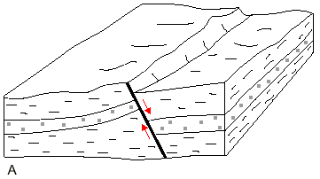
Figure 6b--Where one side of the fault is pushed up and over the opposite side along a steep fracture, it is called a "reverse fault."
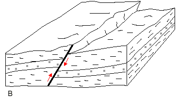
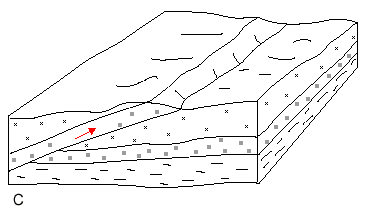
Figure 6d--This block diagram of a wrench-fault zone shows that vertical movement is often very complex. Faults may appear to be normal or reverse along the fault zone, and fault reversals and scissoring are common; horizontal displacement is greater than these vertical complications.
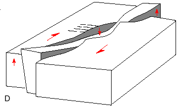
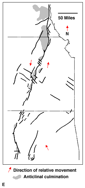
Figure 6e--"Wrench faults" occur where one side of the fault moves slong several, often sinuous, faults, such as shown here along the Nemaha or Humboldt fault zone in eastern Kansas.
Fractures in otherwise tight, nonporous rocks can themselves be open, providing "fracture porosity" that may contain petroleum. Thus a shale or dense limestone may be fractured and contain oil, forming another type of structural trap. Fractures commonly break through porous rocks and increase the permeability greatly by providing pathways that interconnect rock pores. Fracturing may be much more important in forming reservoirs in Kansas than we realize. Recent research on porosity and permeability development in shallow Pennsylvanian sandstones of southeastern Kansas and northeastern Oklahoma indicates a clear link between production and fracture patterns as mapped at the surface. Fracture porosity is also a component of the pore space in reservoirs in the Hugoton gas area. Ancient weathering along fractures has enhanced reservoir development in fields producing from the Arbuckle Group in the midcontinent.
An important characteristic of all structures, but of wrench-fault zones in particular, is that once a fold or fault begins to move, it is a zone of weakness for all remaining geologic time. Movement will recur each time properly oriented stresses are generated in the crust of the Earth for whatever reason. Consequently, structures originating in Precambrian basement rocks may have been rejuvenated repeatedly throughout geologic history. Each time there is renewed movement on a structure, be it ever so slight, overlying rocks are shuffled up or down, perhaps only by inches or a few feet. Every foot of topographic relief on the seafloor affects the nature of the sediments being deposited, especially in the case of carbonate sediments. Consequently, shoals may develop on the seafloor on and around high structures, and structural depressions become sedimentary basins. Either situation changes the environment of deposition to a degree.
As we have seen, different types of sediments eventually produce different porosity/permeability relationships in the rocks. If the rock type varies due to water depth that is controlled by structural movement during deposition, local variations in porosity/permeability will result. Thus a definite relationship exists between geologic structure and the kind of sedimentary rock that is produced, and stratigraphic traps result.
Petroleum reservoirs produced by structural growth during deposition of sediments are common in Kansas. The myriad oil/gas reservoirs in Pennsylvanian rocks of the Central Kansas uplift are examples, and more are being discovered by drilling every day. A prominent anticline, formed over deep-seated faulting in Haskell County, exhibits recurrent growth which helped develop a series of major oil and gas fields along this structure. The Cahoj field in Rawlins County in northwest Kansas was a topographic high during deposition of the Lansing-Kansas City reservoirs leading, in part, to the stacking of 11 reservoir units in that field. It is still high today. McClain field in Nemaha County produces from Simpson and Viola reservoirs. Both were influenced by ancient topography similar to present-day structure. Other Viola fields along the Pratt anticline in south-central Kansas exhibit early structural growth of this anticline which extends southward from the Central Kansas uplift.
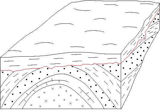
Figure 7--Uncomformity is a surface between rock layers that shows the effects of a period of erosion or nondeposition. In this case, the rocks below the wavy line (uncomformity) were deposited, folded to form an anticline, and then eroded to a plain before the rocks above the unconformity were deposited. Petroleum migrating along any permeable bed may be trapped when it rises to the eroded surface.
Oil and gas migrating upward along inclined rock layers may be trapped at an unconformity if the beds overlying the eroded surface are impermeable. Oil and gas may also have migrated along the unconformity. The major uplifts of Kansas, and some smaller folds and faults, have been elevated, and the resulting tilted strata beveled by erosion at different times during the geologic past. Excellent unconformity traps have resulted, notably along the flanks of the Central Kansas and Nemaha uplifts. Mississippian limestones along the western flank of the Central Kansas uplift contain vast amounts of petroleum beneath the Pennsylvanian/Mississippian unconformity.
Prev Page--Layered Rocks || Next Page--Exploration