Petroleum: a primer for Kansas, Page 4 of 15
Prev Page--Geology of petroleum ||
Next Page--Structure
Figure 3--Geologic time scale showing geological eras and periods recognized in North America from oldest to youngest in ascending order. Length of time of each period and million years before present are rough estimates based on radiometric dating of rocks ad relative rock relationships. Earliest humans did not appear until about the beginning of the Pleistocene Epoch some two million years ago. (Figure from the KGS's GeoKansas web site.)
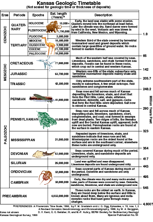
There are many reasons to believe that the Earth formed about 4.5 billion years ago. However, it was not until the beginning of Cambrian time, about 545 million years ago, that sedimentary rocks containing fossils became abundant. The first four billion years of Earth history, lumped by geologists into the Precambrian Era, can only be dated where radioactive minerals are available.
During the remaining half-billion years, the area that is now Kansas was covered repeatedly by shallow seas. Sea level fluctuated hundreds of times, at least relative to the nearly level landscape, and shorelines waxed and waned accordingly. Layered sedimentary rocks accumulated to thicknesses up to 9,500 ft (2,895 m). Remember, though, that there was plenty of time--more than 400 million years! During times of high sea level, limestones were deposited in the shallow, perhaps knee-deep, seas; clastic sediments, sands and mud, were carried to the shorelines by streams that drained the lands. When sea level dropped and the marine deposits were exposed, sediments that had accumulated were subjected to erosion and some were carried back to the sea by streams. The shorelines and their related environments traveled hundreds of miles, back and forth, producing complex rock relationships as the waters deepened or shallowed with time. The study of the sequences and variations in sedimentary rocks is called "stratigraphy."
Depositional edges (pinch-outs) of shoreline sandstones and local build-ups of reefs and carbonate mud banks are numerous in the rocks beneath Kansas. The resulting changes in rock type, and related rock porosity and permeability, formed traps for oil and gas. This kind of barrier to the underground flow of petroleum is called a "stratigraphic trap" (fig. 4). Many of the oil and natural gas fields in Kansas produce from these localized sedimentary variations that recur throughout the hundreds and thousands of feet of sedimentary rock. Gas in the large Hugoton gas area is trapped because porous carbonate reservoirs change laterally to impermeable shales and siltstones.
|
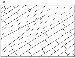
Figure 4a--A sandstone bed is shown thinning to a pinchout in a direction up the dip of inclined strate. Fluids moving up along the tilted porous and permeable sandstone wil be trapped where the sandstone terminates in impermeable shale beds.
|
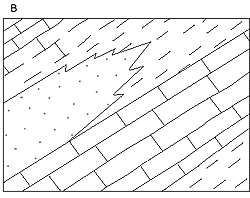
Figure 4b--Permeable beds, such as beach sandstones, often change laterally to other rock types, such as shale as shown in this example. Such a change in rock types is called a "facies change." Petroleum migrating up the inclined permeable strata is trapped when it encounters impermeable shale beds, and an oil/gas field is created.
|
|
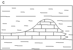
Figure 4c--Reefs and other thickened accumulations of organic debris often form porous and permeable limestones. Where these change laterally to impermeable rock types, a permeability barrier is formed and petroleum can accumulate.
|
Prev Page--Geology of petroleum || Next Page--Structure