
Tuttle Creek Lake Spillway Exposure: Cycle Patterns and Paleosol Profiles
by Keith B. Miller
Department of Geology, Kansas State University
Kansas Geological Survey, Open-file Rept. 94-23.
Abstract
During the recent floods of the midwest, erosion of the Tuttle Creek Lake spillway in Pottawatomie County, Kansas, extensively exposed stacked paleosols within variegated mudstones of the Johnson Shale and Roca Shale Formations (lower Council Grove Group). Lateral variations in paleosol profiles can be viewed continuously for hundreds of meters along fresh vertical exposures. In addition, well over 36,000 square meters of paleosol surface area have been exhumed by erosion and made available for study.
A variety of paleosol types are recognized within the exposed stratigraphic interval. Calcic paleosols contain abundant caliche nodules and carbonate rhizocretions up to 5 cm in diameter. The larger rhizocretions occur in discrete patches or clumps over the exposed ancient land surface. Unusual columnar ped horizons, that may record saline conditions during soil formation, are also displayed within the spillway area. Vertic paleosols have very well-developed pseudoanticlines and pedogenic slickensides. The hummocky surface topography, or gilgai microrelief, characteristic of vertic soils is exposed over large areas.
The paleosol profiles are bounded by flooding surfaces and developed on fine-grained siliciclastic sediments deposited in a shallow paralic depositional environment. Within each stacked series of paleosols, calcic paleosols indicative of semi-arid to sub-humid climates are succeeded by vertic paleosols formed under highly seasonal (monsoonal) wet/dry climates. This pattern is one that has been observed repeatedly within the Wolfcampian cyclothems of northeastern Kansas, and suggests that cyclothem deposition was associated with cyclic climate change. In addition, the occurrence of polygenetic paleosols with both calcic and argillic horizons indicate increasingly dry conditions during individual episodes of subaerial exposure.
Integration of the paleoclimatic and eustatic evidence suggests that within the mid-continent drier climatic conditions prevailed during sealevel highstands and wetter conditions characterized lowstands. A climatic-eustatic model based on the presence of a Pangean monsoonal circulation pattern is presented that explains the observed stratigraphic and paleoclimatic patterns. This model provides a testable alternative to existing glacio-eustatic models for cyclothem formation during the Permo-Carboniferous.
Introduction
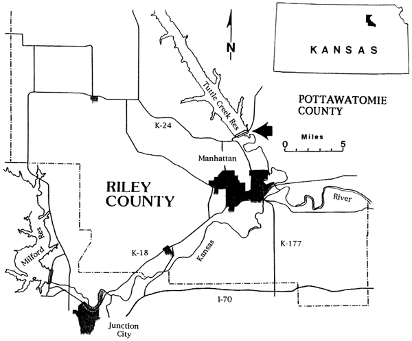
The Tuttle Creek Lake spillway area is located north of Manhattan, Kansas, in westernmost Pottawatomie County (Fig. 1). Following weeks of exceptional precipitation within the watershed of the Big Blue River during the summer of 1993, the Tuttle Creek Lake reached its maximum flood pool at an elevation of 1136 feet, 66 feet above normal. At this point water was released through the spillway gates for the first time since the dam was constructed. Over several days, discharge was increased to a maximum of 60,000 cfs with all 18 gates (each 40 ft wide) raised 4 feet. For a 21-day period from July 19 to August 9, water flowed over the spillway area removing the unconsolidated cover and eroding the bedrock.
Figure 1. Locality map for Tuttle Creek Lake spillway. The arrow marks the location of the Tuttle Creek Lake spillway in westernmost Pottawatomie County (Sec. 19, T. 9 S., R. 8 E.). The eroded section is located immediately south of K-13 and the spillway tainter gates on the east side of the Tuttle Creek dam.
The resulting erosion of the spillway exposed about 30 meters of the lower Council Grove Group stratigraphic section containing four cyclothem-scale cycles. The eroded spillway area has provided an unparalleled opportunity to examine the well-developed paleosol profiles of the variegated mudstone units. Lateral variability in the thickness and morphology of paleosol profiles can now be viewed continuously for hundreds of meters, and well over 36,000 square meters of paleosol surface area has been exhumed. The fresh unweathered outcrop permits pedogenic features to be easily observed and described in the field.
Stratigraphic and Paleogeographic Setting
The newly eroded Tuttle Creek Lake spillway displays the lowest five formations of the Council Grove Group (Gearyan Stage) (Fig. 2). This stratigraphic interval has been generally understood to be of Wolfcampian age with the Pennsylvanian/Permian boundary placed at the base of the underlying Admire Group. However, a redefinition of this boundary in the midcontinent has recently been proposed that moves it upward to the base of the Neva Member of the Grenola Limestone (Baars, 1990; Baars et al., 1990). Acceptance of this placement would result in a Virgilian age for the spillway section.
Figure 2. Stratigraphic section exposed in spillway. The arrows mark the top and bottom of the newly eroded spillway section. This study focuses on the interval from the top of the Long Creek Limestone Mbr. to the top of the Burr Limestone Mbr.

The Pennsylvanian to Permian transition began a period of major paleogeographic and climatic change with the final assembly of the Pangean supercontinent and the transition from a glacial to a non-glacial world (Veevers and Powell, 1987). A consistent trend toward increased aridity in the North American midcontinent lasted throughout the Permian. This long-term trend is recorded by the increased proportion of red terrigenous clastics, evaporites, and carbonates within the Lower Permian relative to the Upper Pennsylvanian. In addition, the black phosphatic shales and coal beds characteristic of the Pennsylvanian are largely absent in the Permian (Archer and West, 1993). This climatic trend toward increasing aridity can also be followed in the paleobotanical record (Phillips and Peppers, 1984; Phillips et al., 1985; Cross and Phillips, 1990; DiMichele and Aronson, 1992). Such changes are consistent with paleogeographic reconstructions showing the midcontinent drifting into higher latitudes throughout the Permian (Rowley et al., 1985; Scotese 1986; Witzke, 1990). In addition, results of global circulation models for Pangea (Parrish et al., 1982; Kutzbach and Gallimore, 1989; Crowley et al. 1989; Patzkowsky et al., 1991; Dubiel et al., 1991) have strongly indicated the presence of a monsoonal circulation pattern that intensified from the early Permian to a maximum in the Triassic.
During the Wolfcampian the North American midcontinent lay within the low relief interior of the Pangean supercontinent in near equatorial latitudes (~10° N). The highlands of the Ancestral Rockies lay -500 km to the west and the Ouachita and Wichita uplifts were an approximately equal distance to the south. In the late Pennsylvanian, periodic marine transgressions may have flooded the continental interior as far as the Appalachian Mountains, while during maximum regressions subaerial conditions extended nearly to the Midland Basin of Texas (Heckel, 1980). The magnitude of the sealevel fluctuations appears to have declined into the Permian.
Cycle Patterns
The facies sequence of lower Permian cyclothems typically begins with a thin marine limestone overlain by a gray fossiliferous shale/mudstone. One or more additional limestone-shale (mudstone) alternations may follow. An interval of variegated red and green mudstones with extensive paleosol development lies above these shallow marine facies (Fig. 3). Cyclothem boundaries are recognized here at the base of the stratigraphically lowest fossiliferous marine limestone occurring above a paleosol-bearing interval. Commonly, these marine limestones directly overlie and partially truncate the uppermost paleosol profiles. The contacts often appear to be erosive, although little or no relief is evident at an outcrop scale, and are typically overlain by intraclastic beds up to 20 cm thick. As thus defined, the cyclothem-bounding surfaces are equivalent to the transgressive surfaces of depositional sequences (Van Wagoner et al. 1988).
Figure 3. Detailed stratigraphy of paleosol-bearing intervals. Detailed stratigraphic section for the Johnson Shale, Red Eagle Limestone, Roca Shale, and lower Grenola Limestone. Arrows indicate the position of transgressive surfaces (TS) that mark cydothem boundaries, and flooding surfaces (FS) that separate meter-scale cycles. Exposure surfaces (ES) cap most meter-scale cycles. Note the repeated carbonate to clastic pattern of the meter-scale cycles. Written descriptions of this interval are included in section entitled "Descriptions of Stratigraphic Section."
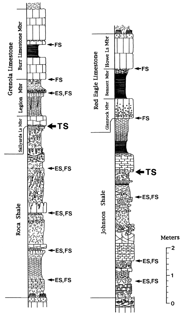
Meter-scale cycles are both ubiquitous and prominent within the Wolfcampian cyclothems of eastern Kansas (Miller et al., 1992; Miller and West, 1993). These small-scale cycles are bounded by flooding surfaces and can be defined as parasequences or PAC's (Goodwin and Anderson, 1985). Flooding surfaces overlie paleosol profiles and other indicators of subaerial exposure, or mark sharp changes in depth as indicated by lithology and fossil content. Within the variegated mudstone intervals, flooding surfaces are typically associated with thin (~1 cm) lags that contain granule-size intraclasts, fish bone, and ostracodes. These flooding surfaces divide the mudstone intervals into packages of paleosol profiles that can be traced for tens or hundreds of kilometers (McCahon and Miller, 1993).
Of particular interest is the consistent carbonate-to-siliciclastic pattern exhibited by the meter-scale cycles (Fig. 3). Within the variegated mudstone intervals of cyclothems, flooding surfaces are typically overlain by thin micritic carbonates. Carbonate deposition thus follows inundation of the exposed land surface during relative sealevel rise and is replaced by the influx of siliciclastic sediments during subsequent sealevel fall. Pedogenesis begins with the subaerial exposure of these clastic sediments during sealevel lowstand. The carbonate-to-clastic pattern is also clearly apparent for meter-scale cycles within the dominantly marine part of cyclothems. Here, bioclastic marine wackestones are overlain by fossiliferous gray shales or calcareous mudstones.