Kansas Geological Survey, Subsurface Geology 6, p. 102-119
by
W. Lynn Watney
Kansas Geological Survey
An Acrobat PDF file containing the complete paper is available (1.6 MB).
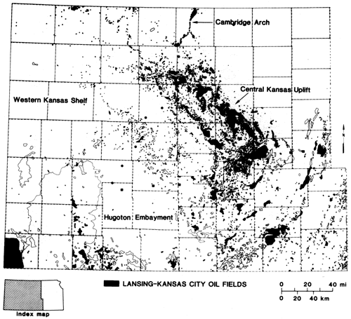
The Lansing-Kansas City has been an important oil-producing interval in Kansas for many years. Oil produced from this interval represents a significant portion of the 5.75 billion bbls estimated to have been in place in Pennsylvanian reservoirs in Kansas (Watney and Paul, 1983). Much of this oil reservoired in Lansing-Kansas City units has been found on the Central Kansas uplift (fig. 1) where oil was first discovered in 1923.
Figure 1--Producing oil fields from Lansing and Kansas City Groups in western and central Kansas. Fields producing from this interval are solid black, while other fields with other pay zones are only outlined. Locations of five cores shown; Stegman, Litsey 4, and Lemon 6 denote locations of core described in this paper. Symbol reflects production status in Lansing-Kansas City interval (dot represents oil producing).
During 1981 and 1982 the Lansing-Kansas City was the leading pay zone in discovery wells while the Mississippian strata maintained second place. Comparisons such as net reserves added by new discoveries may show a completely different picture, but these figures are not available. On the contrary, the Lansing-Kansas City reservoirs are are well known to be discontinuous, and geological factors besides structure are usually important parameters that must be considered early in developing a successful exploration strategy in the search for these reservoirs.
Key ingredients in understanding and exploring for petroleum reservoirs in Lansing-Kansas City carbonates are core data and a suite of logs that accurately resolve the variation of the stratigraphic succession. Rig time is costly and cores are difficult to justify for every hole, but logs and core contain essential geologic information that permits the recognition and correlation of lithofacies. This information also provides geologists with an opportunity to understand more about the type, origin, and distribution of porosity necessary in evaluating prospects in these strata.
The objectives of this paper are as follows: 1) to provide an overview of cyclic stratigraphy and geologic setting of western Kansas; 2) to compare and contrast the observations in the cores chosen in central and southern Kansas (complementing other papers on the Lansing-Kansas City presented in this compilation); and 3) to integrate the observations made from the cores into a regional depositional setting, relating the results to exploration strategy.
The Lansing and Kansas City Groups are an Upper Pennsylvanian (Missourian) age succession of some dozen repetitions each composed of a transgressive carbonate, a marine shale, and several regressive lithofacies. These cycles are dominated by the regressive carbonate, generally the site of the petroleum reservoir. The component lithofacies are as follows, listed from top to bottom:
or in cyclothem nomenclature-originating with R. C. Moore (1929) and later modified by Heckel and Baesemann (1975):
The transgressive carbonate and marine shale are typically thin in all cycles in western Kansas. Furthermore, the marine shale can be a strong emitter of natural gamma radiation and thus provide a striking response on a gamma-ray log.
The Swope Limestone, the focus of this paper, hereafter referred to as the K-Zone, contains the excellent subsurface marker bed, the generally black Hushpuckney (marine) shale. The correlation is particularly clear in combination with another marker in the overlying J-Zone (the Stark Shale Member of the Dennis Limestone described by M. K. Dubois in this volume). The letter nomenclature is in common use in the subsurface of western Kansas, originating from Morgan (1952). Parkhurst (1959) established the correlation between this subsurface nomenclature and the formal outcrop names.
The vertical heterogeneity of lithofacies in the Lansing-Kansas City does fit a cyclic template dominated by regression, i.e., shallowing-upward succession. A simple model of sediment progradation and aggradation does not adequately explain the generation of the K-Zone cycle, but rather other regionally significant mechanisms such as eustatic sea-level change have been proposed (Moore, 1929; Wanless and Shepherd, 1936; Heckel, 1977, 1980).
The major conclusions reached by Watney (1983) concerning mechanisms of cycle development include: 1) the major mechanism producing the cycle is an oscillating change in eustatic sea level on the order of a minimum of 200 ft-first the sea rapidly inundating the shelf, then sea level more slowly falling until essentially all of the shelf in western Kansas is emergent, permitting flushing by freshwater and resulting early diagenesis, and 2) time-variant episodic changes of relief of the depositional surface across western Kansas producing second-order changes in facies distribution in each of the lithofacies components.
The cores of the K-Zone described below were chosen specifically to illustrate evidence for subaerial exposure of the K-Zone regressive carbonate all which preceded the next shelf-wide inundative event (J-Zone). Secondly, the choice of three cores distributed across central and southwestern Kansas, representing only portions of the K-Zone in the two southernmost examples, was done to compare and to contrast the late regressive processes of the K-Zone on the Central Kansas uplift, on the flanks of the Pratt anticline, and on the southwestern shelf during K-Zone deposition (fig. 1). Several maps are shown to assist in obtaining this perspective. Details of the shelf setting in western Kansas are available in Watney (1984). A general diagenetic model for the Upper Pennsylvanian cyclothem is described by Heckel (1983). Nollsch (1983) evaluated this model for the Swope Limestone along the outcrop area in eastern Kansas to southwestern Iowa.
Western Kansas was the location of a broad stable platform during the Late Pennsylvanian. The Lansing-Kansas City was deposited some 20 m.y. after the major tectonic movement of the Central Kansas uplift (CKU) and the Cambridge arch (CA) during the Late Mississippian and earliest Pennsylvanian. The positive residual relief on the CKU and CA were finally covered with Pennsylvanian sediments by the time of K-Zone (Swope) deposition. Locally the K-Zone lies directly on the Precambrian surface over local positive elements on the crest of the CKU. Isopach and lithofacies maps of Pennsylvanian strata reveal the positive nature of these features (figs. 2-4).
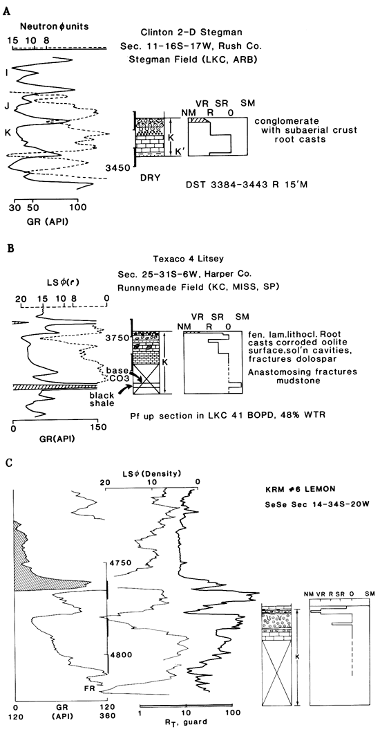
Figure 2--Perspective diagram of the marine-interval thickness of the K-Zone looking southwest over the study area in western Kansas. Above the perspective diagram are the various subdivisions of the depositional platform based on core and isopach information. Areas of flexure represent regions of rapid thickening and marine interval of K-Zone; areas of flexure border the Anadarko Basin immediately south, a basin which was subsiding rapidly during the Missourian. The approximate locations of the cores are located by the arrows: Stegman on the Central Kansas uplift (CKU) positive area, Litsey on the flanks of the Pratt positive area, and Lemon on the Hugoton flexure area.
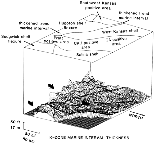
Figure 3--Contour map of total thickness of porous carbonate in the K-Zone regressive carbonate reflecting 2,300 points of control; contour interval is 5 ft. Labels include township numbers around the edge of the diagram and county outlines (dashed) and their abbreviations. Note the township-sized porous lobes that terminate northward in the vicinity of Lane (LE), Hodgeman (HG), and Edwards (ED) Counties in the south-central portion of the study area indicated here between the two arrows. This porosity trend coincides with the northern edge of the Hugoton shelf flexure (fig. 2). The dominant porous carbonate facies here is oolite. The Lemon core is representative of this trend.
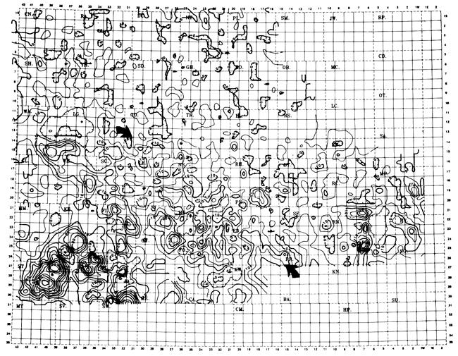
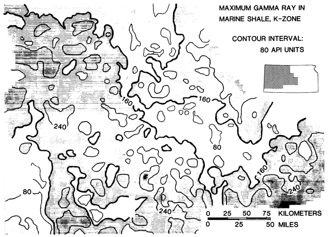
Figure 4--Variable-density contour map of the maximum natural gamma radiation recorded in the marine shale of the K-Zone; contour interval is 80 API units. Note that 160 API contour is heavier and essentially outlines the regions of the Central Kansas uplift, Cambridge arch, and the southwest Kansas positive area previously identified as isopach thins (fig. 2).
The region south and west of the CKU-CA during Missourian time represented a stable carbonate-dominated shelf setting at least as far south as the Oklahoma-Kansas border. South of this area a constructive carbonate shelf margin has been described (Rascoe, 1962; Lane, 1977; Kumar and Slatt, 1982) beyond which the Missourian carbonate succession rapidly diminishes in thickness into the Anadarko Basin.
Three sets of illustrations are used to describe the three cores chosen in this study. Figs. 7, 8, and 9 are descriptions of each core providing a graphic log keyed to the legend for lithology and particle and fossil types shown in fig. 6. A column marked "facies" in figs. 7, 8, and 9 is coded according to fig. 5. Another column labeled "diag. overpr." (diagenetic over-printing) is keyed also to fig. 5. A brief description of the lithologies is included for each core. While the entire 17 ft of the K-Zone in the Stegman core is displayed in fig. 7, only the very upper, cored portions of the K-Zone are illustrated in the other two cores, only 19 ft of the 43-ft-thick K-Zone in the 4 Litsey well (fig. 8) and 16 ft of the 50-ft-total thickness in the 6 Lemon well (fig. 9).
Figure 5--Legends providing code and descriptions of depositional facies and diagenesis for figs. 7, 8, and 9.
| Clastic facies | |
|---|---|
| B | black shale with conodonts, fish scales, phosphate |
| DG | dark-gray shale--restricted fauna, orbiculoid brachiopods |
| GGR | green to gray shale, normal marine fauna including crinoids, brachiopods, bryozoa |
| GRQ | green quartz siltstone to claystone, lacks normal marine fossils |
| RB | red-brown, maroon shale or siltstone |
| CON | mixed pebble carbonate conglomerate |
| Diagenetic overprinting | |
| M | molds |
| V | vugs |
| CSP | microgranular calcite spar |
| DSP | dolospar |
| s | silification |
| F | fractures |
| SC | solution channels |
| IB | in situ breccia |
| SHC | sheet cracks |
| CIRC | circumgranular cracks |
| RC | root casts |
| /// | noticeable recrystallization |
| fissures--solution-enlarged vugs | |
| Carbonate facies | |
| 1-O | brachiopod |
| 2-O | crinoid-brachiopod |
| 3-O | bryozoan |
| 4-O | fusulinid-crinoid |
| 5-SR | tubular (encrusting) foram + O (Osagia) + B (brach-crinoid) + G (gastropod-bivalve) restricted to slightly restricted marine |
| 6-O-SR | phylloid algal, tubular foram, brachiopod, crinoid |
| 67-SR | gastropod - bivalve (mollusk) - ostracod |
| 8-R | silty, argillaceous micrite (mudstone) |
| 9-VR | peloidal, laminated, fenestral micrite, very restricted |
| 10-H | diverse skeletal packstone-grainstone, open marine |
| 11-H | oolite |
| 12-H | pellet, peloid, restricted skeletal packstone-grainstone, restricted marine |
| 13-H | Osagia grainstone-packstone |
| 14-S | subaerial crust |
| 15-S | caliche |
| 16-0 | hardground |
| STR | stromatolite |
Figure 6--Additional legends providing symbols for particles, fossils, and lithologies used in graphic columns of figs. 7-12.
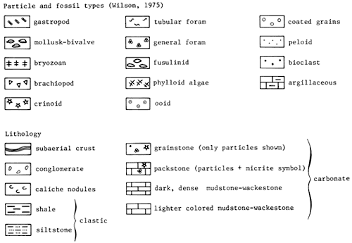
Fig. 10 illustrates the combined graphic core and wireline logs for each cored well. The box along the right side of each illustration in fig. 10 represents an environmental interpretation described in the figure caption. Notice that the entire K-Zone is identified in the graphic, even though it was not entirely cored. Selected illustrations of core slabs and photomicrographs follow in figs. 11-13.
The 2-D Stegman core (sec. 11, T. 16 S., R. 17 W.) is located on the crestal area of the CKU and the northern edge of a local northwest-trending Precambrian high called the Rush rib (Merriam, 1963; fig. 1). The Rush rib is also the location of a Pennsylvanian isopach thin and structural high. The cored interval in the Stegman well cut the I- and J-Zones as well as the K-Zone (figs. 7, 10, and 11). The topmost surfaces of each of the regressive carbonates in the J, K, and L contain well-developed subaerial crusts indicating that this area became emergent immediately following the accumulation of carbonate sediment. The regressive shale in the J-Zone is a red-brown shale with caliche mottling, representing a well-developed soil zone typical of that seen in most cycles in northern Kansas. Furthermore, the upper surface of the underlying J-Zone carbonate is strewn with corroded, blackened, pitted clasts of dense, brown micrite lying on the subaerial crust. In the K-Zone, which is of interest here, the very thin (centimeters thick) regressive shale is green and unfossiliferous. The shale contains dark-brown solution-pitted fitted clasts of grainstone that again rest on top of a subaerial crust. This shale may actually be an infilling between in situ particles at the weathered top of the K-Zone regressive carbonate. The overlying fossiliferous shale of the next transgression (J-Zone) sharply overlies this shale. This contact very likely may be erosional in origin.
Figure 7--Core description of Clinton #2-D Stegman located in the SE NW NE sec. 11, T. 16 S., R. 17 W., Rush County. Depths along left margin in feet, graphic column with symbols described in fig. 6, and facies and diagenetic overprinting symbols described in fig. 5. Cores described with the use of Dunham's (1962) classification of carbonates.
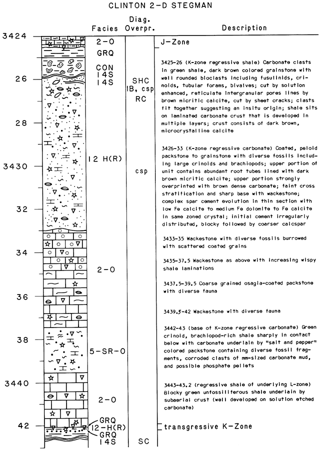
The dark-brown, laminated, micritic crust in the upper K-Zone consists of multiple surfaces, each well developed and distinct. Literature on characterizing and interpreting other ancient subaerial crusts is abundant. These surfaces are referred to as caliche crusts, carbonate crusts (James, 1972), calcrete (Klappa, 1979), laminated soil stone crusts (Robbin and Stipp, 1979), desert stromatolites (Krumbien and Giele, 1979), cornstone (Steel, 1974), and subaerial laminated crusts (Multer and Hofmeister, 1968). Undoubtedly as more varieties are recognized and distinguished from hardgrounds, blue-green algal stromatolites, and other discontinuities, more credibility will be given to this thin, but very diagnostic, evidence for subaerial exposure.
Other related diagenesis within the grainstone in the upper K-Zone include the enhancement of intergranular pores to form a reticulated pore system coated by the same micritic carbonate that forms the subaerial crusts (Watney, 1984). Root casts, millimeter sized and lined again by the dense micritic carbonate, pepper the upper K-Zone. Also the upper carbonate is broken by sheet cracks (Dunham, 1969). Uppermost portions of the K-Zone carbonate are almost entirely composed of this early diagenetic, freshwater carbonate. Lower in the unit other related freshwater alteration is present including molds, vugs, and patchy recrystallization of micritic to microgranular (porous) calcite spar.
Below the upper grainstone, which is classified as a high-energy restricted (shallow-water) shelf facies, the regressive carbonate is mainly an open-marine wackestone, but near the base this carbonate is interrupted by 2 ft of tubular foram, blue-green algal-coated (Osagia) packstone perhaps representing a slightly restricted, marine environment. The agitation of the bottom is conjectural, but the particles are rounded and coated on all sides. While the general environment was low energy, the bottom may have been periodically agitated by storms with large waves with a particularly deep fetch. Lime mud could be removed while grains could be rotated to again continue to be encrusted after these storms. The unusual occurrence of this accumulation of coated grains suggests shallower waters at this site than in most other locations on the shelf. However, foraminifera-bryozoan-worm algal nodules are noted at a depth of approximately 125 ft off the Florida reef tract (Enos, personal communication, 1984). If the osagid facies is analogous to this modern example, deep, quiet, and open-marine conditions would still be the dominant environment at this position. Bottom agitation occurred early at this site shortly after the regressive carbonate began to accumulate.
The base of the K-Zone in the Stegman core is a thin, green, very fossiliferous shale covered by a thin, diversely fossiliferous packstone that contains probable phosphatic peloids and corroded clasts of carbonate rock. This is the transgressive unit, sharply overlying the thin, regressive shale of the underlying cycle. The overlying wackestone of the regressive carbonate rests on the packstone without the intervening Hushpuckney marine shale. Immediately off the crestal area of the CKU, the same unit was deposited and is black and dense. A hiatus must have existed at the top of the transgressive packstone as suggested by the accumulation of phosphate peloids. In any case, the bottom-water conditions were different over the uplift than over areas on either side during the accumulation of marine shale. From the regional examination of four Kansas City cycles in western Kansas (Watney, 1984), the site of the Stegman core was consistently the location for: 1) a condensed succession of lithofacies; 2) missing marine shale or low gamma-ray -emitting facies of the marine shale; 3) a transgressive, thin, lag conglomerate consisting of eroded particles and marine skeletal debris; 4) thin or missing regressive shale; 5) distinctive and abundant evidence for subaerial exposure and rather extensive (intense) levels of freshwater diagenesis of the carbonates; and 6) shallow-water and slightly restricted to restricted marine-carbonate facies occupying a large portion of the regressive carbonate.
Pronounced subaerial exposure and freshwater diagenesis are recorded in other cores that are located on the CKU. Frequently, the development of secondary porosity associated with subaerial exposure such as solution vugs, fissures, fractures, and recrystallization of micrite have resulted in abundant, sometimes spectacular, reservoir development, almost independent of the original depositional facies. Previous experience of the author (Watney, 1980) and that of other workers in these sedimentary rocks (Brown, 1963; Dubois, 1979; Prather, 1981) has recognized the importance of grain-rich (generally higher-energy) carbonate rock in reservoir development. Grainstones directed the flow of undersaturated (fresh), dissolving waters into underlying mudstones and wackestones, perhaps creating secondary porosity, and were commonly stabilized under new diagenetic conditions with both the partial cementation of primary porosity and also the creation of new, secondary porosity.
What about the development of the cycle that was prevalent over regions flanking the CKU during the K-Zone? While the K-Zone is an important producing zone on the CKU, it also is one in areas west and south of the CKU. Not all areas are porous and permeable though, so what can account for the variation and how does this variation affect exploration strategy?
The 4 Litsey core of the K-Zone (the second core described here) is located on the flanks of the Pratt anticline. The regional maps indicate that the location during the deposition of the K-Zone was a positive spine that extended southward off the CKU, coinciding very closely with the present-day structural configuration (fig. 2).
Fig. 8 only includes the upper 19 ft of the K-Zone. The contact with the overlying transgressive portion of the J-Zone is present indicating a marked change in depositional environment from that of the latest stage K-Zone (figs. 8, 10, and 12). The very top of the K-Zone is extensively altered by freshwater diagenesis though less apparent than in the Stegman well. However, definitive evidence for subaerial exposure also exists at this site. For example, the dense, brown, micritic calcite cement rims solution voids and root tubules (RC). This cement is essentially the same cement that composed the subaerial crusts in the 2-D Stegman core.
Figure 8--Core description of Texaco #4 Litsey located NE NE NW, sec. 25, T. 31 S., R. 6 W., Harper County.
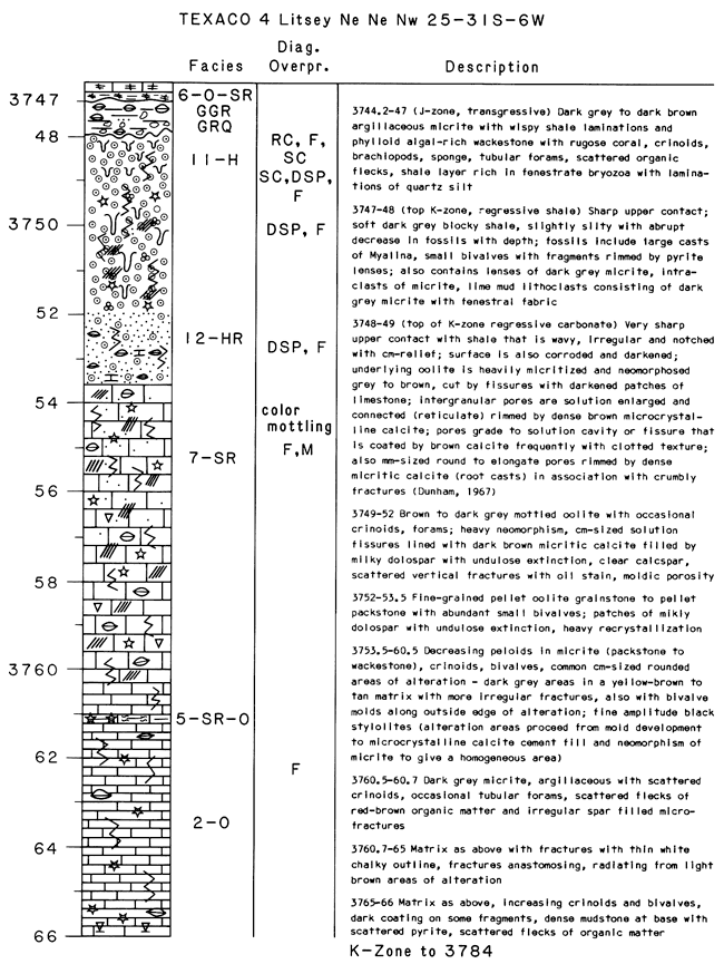
Clasts of what seem to be early lithified, micritic calcite from the upper corroded surface of the K-Zone regressive carbonate are now emplaced in a matrix of unfossiliferous silty shale. The reworking and scattering of particles preceded the overlying transgression and are likely related to the weathering and exposure of the K-Zone also suggested by other evidence. Solution cavities, fractures, crumbly fractures, collapsed ooids, and heavy, patchy, neomorphosed micrite further substantiate the importance and intensity of freshwater diagenesis at this location on the shelf. What is different between the Litsey and Stegman cores is described in fig. 10 and summarized as follows: 1) the cycle in the Litsey well is markedly thicker, although for a southerly shelf location it is actually only of intermediate thickness (see wirelog, fig. 10); 2) the Hushpuckney shale is highly radioactive in the Litsey well; 3) the facies succession is open marine to almost the very top of the cycle in the Litsey well; and 4) the lower cored interval of the regressive carbonate is low-energy, dense, darker carbonate in the Litsey well, a facies which is not common to the upper (northern) shelf.
The prominent differences that exist between the 6 Lemon and the 4 Litsey cores and that of the 2-D Stegman well are their greater thickness, thin restricted-marine facies compared to the Stegman core, and oolite vs. uncoated or only lightly coated bioclasts in the Stegman core . Note that although core is not available from the lower regressive carbonate, this interval has a higher gamma ray than in comparable positions in the regressive carbonates generally seen in the north. The portion logged in the J-Zone above the K-Zone in the 6 Lemon well also is similar. Cores from other wells from the southern area suggest that this lower carbonate is slightly to moderately argillaceous, dark colored, and contains flecks of organic matter. Previous work (Watney, 1979) suggests that the gamma ray alone is not a good measure of shale content in the lower regressive carbonates because of this organic matter (OM) and associated adsorbed uranium.
The oolite facies is leached and cemented, locally with solution of cement and collapsed oomolds and shards of cement. Coarse cements, blocky and scalenohedral calcite, abundant neomorphism of ooid cortices, and patchy recrystallization and discoloration of the wackestone that underlies the oolite are very prominent evidence of early diagenesis. Most of these observations are seen in thin section and are not readily apparent from the slab itself.
The alteration of the wackestone is analogous to a leopard pattern with irregular centimeter-sized patches of darkened micrite. Petrographic analysis indicated darkening is due to the presence of semi-opaque microcrystalline material, perhaps clay. This material is associated with microspar, pinpoint-sized vugs, and irregular, discontinuous fracturing. Similar patterns also are observed in micrite-rich sections beneath other oolitic grainstones from zones other than the K-Zone. The 6 Lemon core also shown here has this same alteration pattern in the wackestone beneath the oolite. Furthermore, the Swope limestone in a US-69 roadcut near LaCygne, Kansas, has this same alteration and duplicates these textural relationships.
The porous interval in the K-Zone of the 4 Litsey well coincides with the oolitic grainstone as indicated by the density-porosity curve in fig. 10. This oolitic zone also is the most shale-free (cleanest) carbonate interval of the K-Zone according to the gamma-ray log. Eight percent porosity normally is considered the lower limit of effective (permeable) pore space but is only a rule of thumb for reconnaissance mapping. Combination porosity tools with consideration of lithology provide a better evaluation of the type and expected distribution of porosity, e.g., primary and secondary. Oomoldic porosity, which is common in this core, is notorious for high porosity values that are not effective. Tortuosity of the complex pore systems when this porosity is effective increases the formation factor in the Archie water-saturation equation. This increase in turn lowers the water saturation determined by log analysis, making the zone seem to contain a greater hydrocarbon concentration than it probably has. Cores allow visual examination of oil saturation and pore structure and together with analysis of porosity and permeability of the core provide information necessary to calibrate the wireline logs.
The 4 Litsey core is from the Runneymede field which contains four separate pay zones including Lansing-Kansas City, Marmaton, Mississippian, and Simpson. Since its discovery in 1953, the field has produced 705,000 bbls through the end of 1982, now including 12 wells. The field lies on the crest of a southerly plunging anticline at the horizon of the K-Zone. Regional dip is to the southwest. Structural closure at the horizon is less than 10 ft.
The last example of the K-Zone described here is from the 6 Lemon well (sec. 14, T. 34 S., R. 20 W.) located in the Collier Flats-Lemon Ranch field complex in Comanche County in southwestern Kansas (fig. 1). This area is off the major structural uplifts, sitting on the east flank of the Hugoton embayment. The field is situated on and near the crest of a south-southwesterly plunging anticline. Updip well locations on the northeastern reaches of this structure are not productive. Pay zones include Douglas, Lansing-Kansas City, and Mississippian.
The Lemon Ranch field discovered in 1979 has produced over 400,000 bbls from 22 wells, most of the oil coming from the Swope or K-Zone. The 32 wells of the Collier Flats field have produced in excess of 600,000 bbls of oil again primarily from the K-Zone.
Figure 9--Core description of KRM Petroleum Corporation, #6 Lemon located in SE SE sec. 14, T. 34 S., R. 20 W., Comanche County.
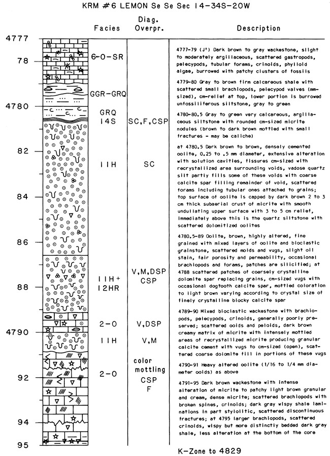
The 6 Lemon core of the K-Zone contains a subaerial crust capping the oolitic grainstone (fig. 13). Clasts of dense, laminated micrite overlie this surface, apparently remnants of a weathered and eroded crust now incorporated into the overlying unfossiliferous siltstone. As in the 4 Litsey core, the reworking process associated with the next transgression is marked by a thin fossiliferous shale with a sharp basal contact separating it from the unfossiliferous siltstone. Evidence of freshwater diagenesis is again abundant.
Again the cleanest interval of the regressive carbonate is the oolite according to the gamma-ray log (fig. 10). The oolite facies is a modest 6 ft thick, but locally exceeds 20 ft in thickness. Apparent porosity in excess of 8% coincides with the oolite. High porosity and high resistivity together with clean carbonate rock with interconnected pores strongly suggest a productive interval. Pipe was in fact run in this hole and the zone was perforated for production. Since the field's discovery in January 1979, 10 wells have been drilled on the Lemon lease. The lease had produced 243,000 bbls of oil at the end of 1982.
Figure 10--Combined wireline log and graphic core descriptions of (A) #2-D Stegman, (B) #4 Litsey, and (C) #6 Lemon. Note that entire K-Zone interval is denoted as well as other lithofacies not cored but suggested by wireline logs. Box to right of each description indicates depositional environment interpreted from core (dashed in area not cored). Abbreviations are as follows: NM-nonmarine, VR-very restricted, R-restricted, SR-slightly restricted, 0-open marine, and SM-stagnant marine; scale in ft immediately to the right of the wireline curves in (A) and (B) and between gamma-ray and density curves in (C). Note that vertical scale is the same in (A), (B), and (C). Hatched patches in (B) represent noticeable recrystallization. FR in (C) means first recording of gamma ray. The zones producing in the fields associated with the core are abbreviated in the headings except for the #6 Lemon which is part of the Lemon Ranch-Collier Flats field with Toronto, Kansas City, and Mississippian pays.
A useful aid in evaluation of facies is a map of the thickness of porous carbonate that exceeds 8% porosity. Thicknesses of porous carbonate in the vicinity of the Lemon core are comparable to the values along the trend of thick porous carbonate indicated in fig. 3 between the arrows.
The lower open-marine, crinoid-brachiopod wackestone in cores on the southern shelf as previously mentioned generally are dark colored and contain flecks of organic matter. These units may be transitional to the underlying marine shale deposited when bottom conditions were stagnant and euxinic with slow sedimentation rates. As sea level fell, the circulation was re-established and normal bottom oxygenating conditions gradually were restored. The maximum gamma radiation recorded by the marine shale is low and is comparable to that of the regressive shale over the positive areas of the CKU, CA, and the northern shelf (fig. 4). Bottom stagnation apparently was not established over these areas. Shallower water conditions were not conducive for preservation of organic matter along the northern shelf perhaps due to more oxygenated conditions where higher rates of sedimentation may also have led to the dilution of the organic matter.
These variations in facies in the lower regressive carbonate of the 6 Lemon core suggest a more basinward, downslope setting where thicker carbonate accumulated, the base of which was more transitional to the once-stagnant bottom conditions prevalent during the marine shale deposition. The oolite facies also is the dominant shallow-water facies along this southerly shelf also recognized in the 4 Litsey core.
Previous results (Watney, 1984) conclude that the oolite belt is very significant indeed. It is not developed on the upper shelf or common to some cycles (e. g., H-Zone) with the exception of the extreme southern shelf where oolites seem to be main facies reflecting carbonate buildup as the carbonate shelf breaks into the Anadarko Basin. The Anadarko Basin apparently was rapidly subsiding, where deep water was maintained during Late Pennsylvanian (Kuman and Slatt, 1982; Moore, 1979; Galloway et al., 1977; Rascoe, 1962).
Subsidence along the southern margin of the Hugoton embayment was greater than in the northern region of western Kansas. A zone of abrupt thickening trending west-northwest across west-central to south-central Kansas is the location south of which oolite becomes the dominant shallow-water facies. Even though differential subsidence was likely a factor in the development of oolite, a fall in sea level to a position where the strand line coincided with this "hinge or flexure zone" finally provided conditions where wave and current energy focused on the break in slope and oolitic shoals developed.
The area to the north was emergent by this time as the strandline made its southerly migration. In fact, lobe-shaped bodies of oolitic grainstone tens of feet thick and miles in length point northward onto the upper shelf following along the line of flexure, resembling the spillover lobes developing today in the Bahamas. Tidal currents moved the ooids locally, but storms were probably the dominant force in moving the oolite northward onto the shallower platform to form the extending fingers.
Oolite complexes are not part of the upper shelf facies because of the distance from the southern shelf edge. A more gradual regional slope dissipated much of the tidal energy necessary to agitate the grains and develop the thick oolitic cortices. Nevertheless, storm currents and even lesser currents more normal to the northern shelf over paleohighs worked the carbonate sediment, removing mud (winnowing) and very locally transporting and sorting grains. Typically though grains on the northern shelf are micritized or darkened because of sitting on the sea floor being attacked by endolithic algae, are encrusted by forams and/or algae, and/or have superficial oolitic coatings (e.g., 2-D Stegman core).
The marine waters that inundated the western Kansas shelf from the south did slowly shallow. Moderate-high energy facies tracts moved progressively across the shelf, focusing on paleohighs and along breaks in slope oriented parallel to the strike of the bathymetric slope. Porosity developed in the upper regressive carbonates commonly is a reflection of these grain-rich facies as substantiated by the cores. Mapping thickness of porosity and relating this to the interval isopachs and gamma-ray mapping of the marine shale have outlined favorable trends related to the configuration of the shelf and the change in sea level. The evidence of subaerial exposure in all three cores shown here including the southern shelf document that the sea did for a short time leave the shelf high and dry, allowing early freshwater diagenesis to take over and modify these carbonates. The magnitude of sea-level change is availed by the isopach and facies data. The paleoslope from the isopachs is roughly 0.5 ft/mi over the 2.0-mi-wide shelf across Kansas that makes the total relief approximately 100 ft less than that filled in by sediment aggradation estimated to be around 30 ft based on facies and interval isopachs. On the northern shelf, Dubois (1979) shows evidence of substantial erosional downcutting and red-shale-filled fissures in the J-Zone. Watney (1980) documents the progressive, northward increase In intensity and duration of exposure in the G-Zone to where the top has been eroded to form a conglomerate. The paleorelief, the facies, and the diagenesis suggest sea-level fall and withdrawal rather than simply sediment fill to sea level.
Either the platform moved upward and downward periodically or a dynamic sea level existed where rates of rise and fall produced these cycles (cycling every 250,000-400,000 yrs). The resulting hiatus between cycles is subtle and even more so on the southern shelf because of the shortness of time, but the effect on the fabric of the carbonates including pore distribution is substantial indeed.
The mechanism causing the sea-level fluctuation has been suggested to be Gondwanan continental glaciation (Wanless and Shepherd, 1936; Heckel, 1977; Crowell, 1979; Watney, 1984). The broad shelf in western Kansas and over the continental interior was near sea level. Undisputable evidence for large glacial advances in Gondwana could easily account for sea-level changes of 100 ft or even 300 ft and could have been the major force behind the cyclic phenomenon observed in these sediments in Kansas.
Secondly, the periodicity of glacial advance and retreat corresponding with sea-level fall and sea-level rise necessary to fit the cyclicity of the sedimentary record is no problem if this Pennsylvanian waxing and waning of glaciers was anything like the Pleistocene. Furthermore, evidence from the Pleistocene glacial stages suggests rapid glacier retreat, i.e., rapid sea-level rise, followed by a slower glacier advance, i.e., sea-level fall that takes a longer time. Also sea-level inundation on the shelf would tend to accelerate with the steady subsidence on the shelf.
How does all of this relate to exploration strategy? First, it is essential to be able to identify the cyclic succession in the zone of interest. Core data are the only way to recognize this including subtle diagenetic features that illustrate the processes that have affected the cycle. What is the porosity type and is it possible to identify trends of similar porosity development on a map? Secondly, it is necessary to tie the core data to the available wireline logs, transferring key information such as facies relation to porosity development. Other factors such as thickening or thinning of the regressive carbonate or the patterns of maximum gamma radiation in the marine shale establish collaborating evidence for the recognition of reservoir trends.
Structural interpretation done concurrently with the stratigraphic study will help to focus on acreage where the two are in a favorable development. Moreover, most likely in western Kansas the stratigraphic-reservoir maps will identify trends that are more wide ranging than the small structural closures identified by the available subsurface control. Unless seismic profiles or potential-field geophysical surveys are available to identify the structural highs, stratigraphic reservoir mapping may be the only way that acreage is picked up to be evaluated further for prospects.
The crux of the whole exploration program is to have core described and analyzed to provide the stratigraphic framework that allows the geologic calibration of the wireline tools and to optimize the integration of existing subsurface information.
Crowell, J. C., 1978, Gondwanan glaciation, cyclothems, continental positioning, and climate change: American Journal of Science, v. 278, p. 1,345-1,372.
Dubois, M. K., 1979, Factors controlling the development and distribution of porosity in the Lansing-Kansas City "E" Zone, Hitchcock County, Nebraska: M.S. thesis, University of Kansas, 100 p.
Dunham, R. J., 1962, Early vadose silt in Townsend mound (reef), New Mexico; in, Depositional Environments in Carbonate Rocks, G. M. Friedman, ed.: Society for Economic Paleontologists and Mineralogists, Special Publication 14, p. 139-181.
Heckel, P. H., 1977, Origin of phosphatic black shale facies; in, Pennsylvanian cyclothems of Midcontinent North America: American Association of Petroleum Geologists, Bulletin, v. 61, no. 7, p. 1,045-1,068.
Heckel, P. H., 1980, Paleogeography of eustatic model for deposition of Midcontinent upper Pennsylvanian cyclothems; in, Paleozoic Paleogeography of West-central United States, T. D. Fouch and E. R. Magathan, eds.: Rocky Mountain Section, Society of Economic Paleontologists and Mineralogists, p. 197-216.
James, N. P., 1972, Holocene and Pleistocene calcareous crusts (caliche) profiles--criteria for subaerial exposure: Journal of Sedimentary Petrology, v. 42, no. 2, p. 387-400.
Klappa, C. F., 1979, Lichen stromatolites--criterion for subaerial exposure and a mechanism for the formation of laminar calcretes (caliche): Journal of Sedimentary Petrology, v. 49, no. 2, p. 387-400.
Krumbein, W. E., and Giele, C., 1979, Calcification in a coccoid cyanobacterium associated with the formation of desert stromatolites: Sedimentology, v. 26, p. 593-604.
Kumar, N., and Slatt, R. M., 1982, Deep-water stratigraphic traps in interior basins-examples from Anadarko Basin, Oklahoma: American Association of Petroleum Geologists, v. 66, p. 59 1.
Lane, S. D., 1977, Relationship of the carbonate shelf and basinal clastic deposits of the Missourian and Virgilian Series of the Pennsylvanian System in central Beaver County, Oklahoma: M.S. thesis, Oklahoma State University, 61 p.
Moore, G. E., 1979, Pennsylvanian paleogeography of the southern Midcontinent: Tulsa Geological Society, Special Publication 1, p. 2-12.
Multer, H. G., and Hoffmeister, J. E., 1968, Subaerial laminated crusts of the Florida Keys: Geological Society of America, Bulletin, v. 79, p. 187-192.
Prather, B. E., 1981, Petrology and diagenesis of the D-Zone megacyclothem of the Lansing-Kansas City Groups, Hitchcock County, Nebraska: M.S. thesis, University of New Orleans, 97 p.
Rascoe, B., Jr., 1962, Regional stratigraphic analysis of Pennsylvanian and Permian rocks in western Midcontinent, Colorado, Kansas, Oklahoma, Texas: American Association of Petroleum Geologists, Bulletin, v. 46, no. 8, p. 1,345-1,370.
Robbin, O. M., and Stipp, J. J., 1979, Depositional rate of laminated soilstone crusts, Florida Keys: Journal of Sedimentary Petrology, v. 49, no. 4, p. 175-180.
Steel, J., 1974, Cornstone (fossil caliche)--its origin, stratigraphic, and sedimentological importance in the New Red Sandstone, western Scotland: Journal of Geology, v. 82, p. 351-369.
Wanless, H. R., and Shepard, F. P., 1936, Sea-level and climatic changes related to late Paleozoic cycles: Geological Society of America, Bulletin, v. 47, p. 1,177-1,206.
Watney, W. L., 1979, Gamma ray-neutron cross plots as an aid in sedimentological analysis; in, Geomathematical and Petrophysical Studies in Sedimentology, D. Gill and D. F. Merriam, eds.: Oxford, England, Pergamon Press, p. 81-100.
Watney, W. L., 1980, Cyclic sedimentation of the Lansing-Kansas City Groups in northwestern Kansas and southwestern Nebraska: Kansas Geological Survey, Bulletin 220, 72 p. [available online]
Watney, W. L., 1983, Carbonate-dominated shelf cycles in Late Pennsylvanian of Midcontinent-intrabasinal and extrabasinal controls on sedimentation and early diagenesis: American Association of Petroleum Geologists, Bulletin, v. 67, no. 3, p. 567.
Watney, W. L., 1984, Recognition of favorable trends in Upper Pennsylvanian cyclic carbonates in western Kansas; in, Midcontinent Paleozoic Reservoirs, N. Hyne, ed.: Tulsa Geological Society, Special Publication No. 2.
Watney, W. L., and Paul, S. E., 1983, Oil exploration and production in Kansas--present activity, future potential: Oil and Gas Journal, July 25, p. 193-198.
Figure 11--Core slab photos and photomicrographs from the Clinton #2-D Stegman (sec. 11, T. 16 S., R. 17 W.), Rush County. Bar scale in all photomicrographs is 1 mm.
A: 3425 ft, slab photo of upper contact of regressive carbonate and regressive shale (K-Zone). Subaerial crust (darker carbonate) at arrow capping irregular surface of limestone unit; note rounded lithoclasts of carbonate in overlying shale.
B: 3,440 ft, slab photo of clear-tan to light-gray mollusk, crinoid-brachiopod-bearing wackestone with burrow mottling typical of the lower regressive carbonate (shallow water possibly slightly restricted). Light-gray less-fossiliferous micrite between stylolites.
C: 3,425 ft, photomicrograph of multigeneration subaerial crust shown in A with laminated and clotted, dense, dark micritic carbonate cement, fractured after it formed. Overlying grains and fracture surface also coated with dense dark micrite.
D: 3,425.1 ft, photomicrograph of interval immediately beneath subaerial crust. Irregularly distributed, dense, dark micritic cement partially coating rounded, poorly preserved bioclasts. Note some of this cement concentrated at grain contacts which hang beneath grains, probably analogous to meniscus and pendant (vadose) cements.
E: 3,425.1 ft, photomicrograph from pellet grainstone containing elongated patches rimmed by dark micritic carbonate. Patches contain more micritized grains, more closely packed together than surrounding spar-cemented grainstone. Patch shown is interpreted as solution cavity rimmed by caliche-like calcite filled by corroded, altered bioclasts.
F: 3,433 ft, slab photo of upper contact of regressive carbonate of L-Zone underlying K. Another subaerial crust with cm-sized relief directly overlain by reworked transgressive portion of K-Zone. Note patches and coatings of darkened carbonate beneath crust.
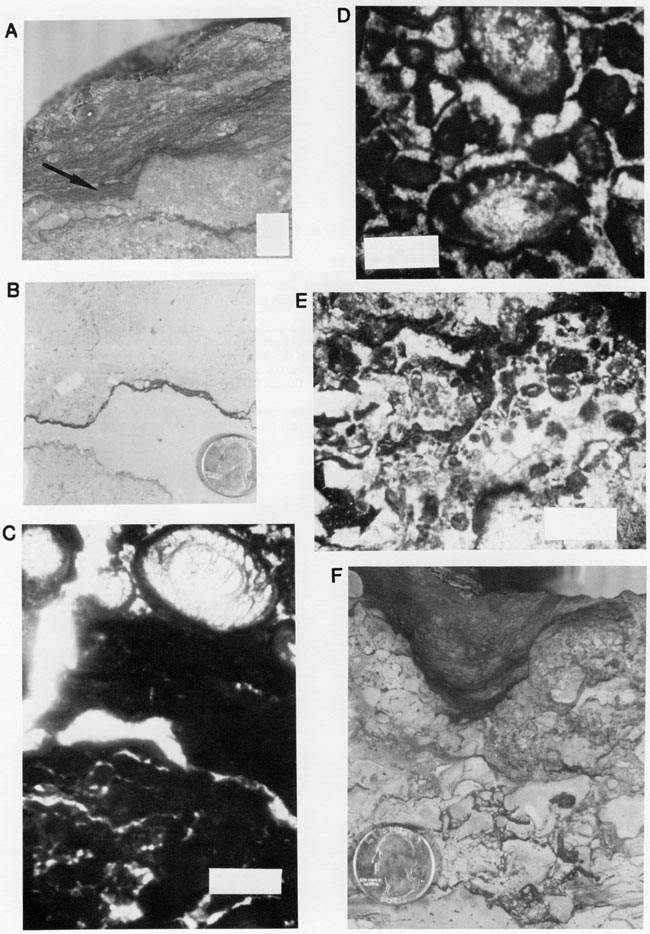
Figure 12--Core slab photos and photomicrographs from the Texaco #4 Litsey (sec. 25, T. 31 S., R. 6 W.), Harper County; bar scale in photomicrographs is 1 mm.
A: 3,745 ft, slab photo of dark, argillaceous, diversely fossiliferous, transgressive limestone of J-Zone.
B: 3,750.5 ft, slab photo of crinoid, tubular-foram-oolitic grainstone with abundant oomolds and vertically oriented patches of darker-colored oolite, containing poorly preserved ooids; irregular areas of coarse milky dolospar.
C: 3,754 ft, slab photo of fine peloid-rich mudstone, cm-sized dark-gray mottling with moldic and fracture porosity and recrystallized lime mud.
D: 3,748.2 ft, photomicrograph in plane light of poorly sorted bioclastic packstone with solution-enhanced intergranular porosity forming reticulated open network of pores (appreciable interconnection even in dimensions of thin section). Note dark micritic carbonate that coats most of this void space; grains again poorly preserved.
E: 3,748 ft, photomicrograph in plane light taken immediately above (D) containing solution cavity lined with very dark carbonate followed by a clotted dark micritic carbonate. Cement that lines void attributed to calicification and suggests subaerial exposure.
F: 3,748.5 ft, photomicrograph in plane light of oomoldic grainstone intensely recrystallized. Original voids filled by blocky to druzy calcite cement. Blue epoxy as black areas only fill some pores (effective porosity).
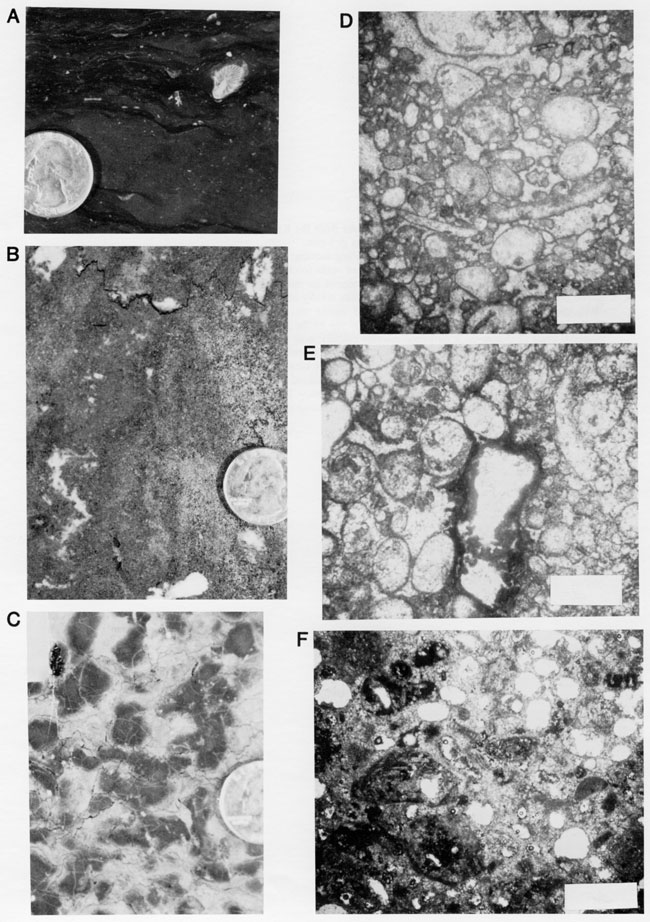
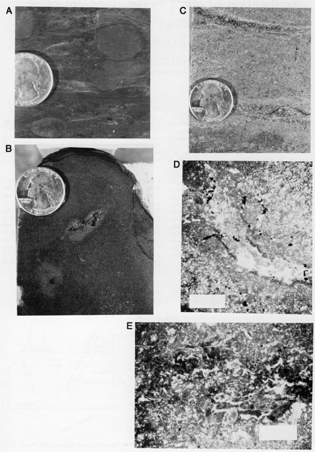
Figure 13--Core slab photos and photomicrographs from the KRM -6 Lemon (sec. 14, T. 34 S., R. 20 W.), Comanche County; bar scale in photomicrographs is 1 mm.
A: 4,780 ft, slab photo of gray-green siltstone containing rounded cm-sized dark mottled lime mudstone clasts with anastomosing fractures and circular-sized mm-sized voids (root casts). Probably eroded remnants of underlying carbonate transported from nearby, containing evidence for subaerial exposure.
B: 4,780.5 ft, slab photo of brown to dark-brown oolite solidly cemented yet cut by solution voids. Note cm-sized cavity partly filled by a layer of lighter-colored quartz silt and ooids resting at the bottom of the cavity. Furthermore, the upper surface of the slab is the top of the K-Zone regressive carbonate. This surface is a subaerial crust (2-3-mm-thick darkened micritic calcite); note the relief.
C: 4,785 ft, slab photo of oolitic grainstone with abundant oomolds and vuggy porosity.
D: 4,780 ft, photomicrograph in plane light of argillaceous siltstone cut by void lined by micritic calcite that is densest adjacent to the void wall. Interpreted as a longitudinal cut through root cast.
E: 4,780 ft, photomicrograph in plane light of clotted, poorly laminated dense micritic calcite alternating with calcspar located in nodular calcareous area in quartz siltstone or regressive shale of K-Zone; resembles caliche carbonate.
Kansas Geological Survey
Comments to webadmin@kgs.ku.edu
Web version April 15, 2010. Original publication date 1985.
URL=http://www.kgs.ku.edu/Publications/Bulletins/Sub6/Watney/index.html