Kansas Geological Survey, Subsurface Geology 6, p. 133-144
by
B. E. Prather
Shell Oil Company
An Acrobat PDF file containing the complete paper is available (1.1 MB).
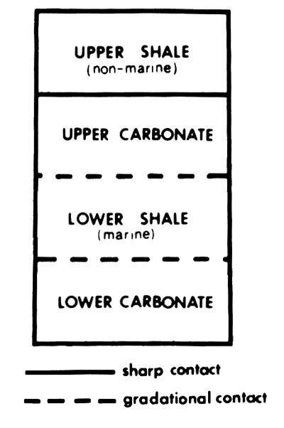
The D-Zone of the Lansing-Kansas City Groups in Hitchcock County, Nebraska (fig. 1), was deposited during one cycle of eustatic rise and fall of sea level during the Late Pennsylvanian (Missourian). The cyclothem is composed of four lithofacies common to most cyclic deposits of this age in the western Midcontinent: 1) a lower carbonate unit (transgressive limestone), 2) a lower shale unit, 3) an upper carbonate unit (regressive limestone), and 4) an upper shale unit (after Watney, 1980; fig. 2).
Figure 1--Map showing Hitchcock County, Nebraska, and surrounding counties in Nebraska and Kansas.
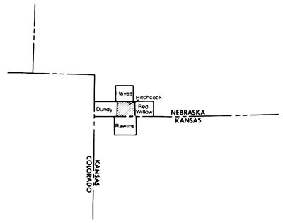
Figure 2--The typical sequence of lithologies common to most cyclic deposits in the Lansing-Kansas City groups of the western Midcontinent (after Watney, 1979).
The lower carbonate and upper carbonate units of the D-Zone are commonly porous and, therefore, serve as reservoir rocks. The lower shale and upper shale units serve as seals for oil that has accumulated in the carbonate units. The interbedded low-relief carbonate/shale stratigraphy is ideal for trapping hydrocarbons in low-relief structural closures, yet many of the present-day structures tested are not productive because of the lack of porous rock. For this reason alone, understanding controls on distribution of porosity in this and similar zones is important.
The core from the Theodore Gore Poindexter No. 1 contains most of the facies typically found in the D-Zone throughout the study area (fig. 3). Examination of it has provided an understanding of the depositional and diagenetic factors controlling the distribution of porosity in this zone. Integration with other cores has extended this interpretation regionally.
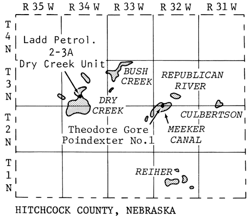
Figure 3--The larger oil fields in Hitchcock County, Nebraska, occur in upper carbonate units (regressive limestones) of the Lansing-Kansas City Groups. The cores examined in this workshop are from the wells indicated by arrows.
The study area in Hitchcock County is located in the northernmost limit of the Hugoton embayment, a broad "shelflike" extension of the Anadarko Basin in western Kansas (fig. 4). The Hugoton embayment was the site of marine deposition throughout the Paleozoic (Merriam, 1954). In the Late Paleozoic, eustatic rise and fall of sea level led to periods of marine deposition and periods of erosion and continental deposition (Merriam, 1954).
Figure 4--The structural and tectonic elements that controlled regional patterns of sedimentation in the Midcontinent during the Late Pennsylvanian (compiled from Moore, 1929; Branson, 1961; Rascoe, 1962; Heckel, 1980; and Watney, 1980).
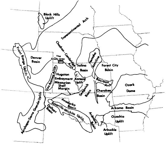
The Cambridge arch, a large anticline plunging southeastward from the Transcontinental arch, lies to the northeast of the study area. It is positioned on the same structural axis as the Chadron arch of Nebraska, the Central Kansas uplift, and possibly the Black Hills uplift. This feature is believed to have been tectonically inactive during Lansing-Kansas City deposition (Merriam and Atkinson, 1955). Still it was a location of positive topographic relief onlapped by Late Pennsylvanian sediments.
The Las Animas arch presently is a broad anticline plunging northwestward away from the Apishapa uplift in southeastern Colorado. Isopachous and facies maps of Pennsylvanian and Permian rocks, however, reveal that an ancestral Las Animas arch dipped southwestward away from the Cambridge arch (Rascoe, 1978). Movement on this feature during deposition of the D-Zone may have subtly affected the distribution of facies, particularly the lime grainstones, in the study area.
The Lansing-Kansas City Groups are the upper two groups of the Missourian Stage of the Upper Pennsylvanian Series. In the western Midcontinent, they have been subdivided by Parkhurst (1959) into formations and members believed to be correlative to their equivalent units in the outcrop belt in eastern Kansas (fig. 5). Recent work done by Burchett (1983) at the Nebraska Geological Survey suggests some modification of Parkhurst's work may be necessary.
Figure 5--Stratigraphic outcrop nomenclature related to the wireline log signatures of the Lansing-Kansas City groups using correlations of Parkhurst (1959). The informal classification scheme used in this study appears at the right of the log trace.
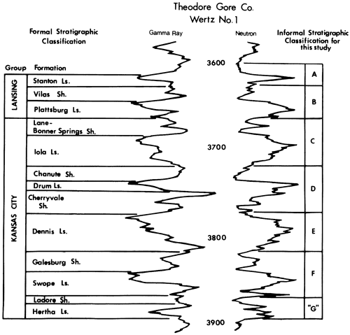
Operators in southwestern Nebraska and western Kansas commonly employ informal classification schemes to divide the Lansing-Kansas City Groups. These classification schemes can vary from operator to operator. At least five such classifications are in current use and all of these vary in applicability and utility. The classification used here is modified from Kincaid, Trimble, and Larson (in Parker, 1961) and illustrated in Dubois (1979, fig. 5). This classification most closely approximates the division of the Lansing-Kansas City in separate sedimentary cycles.
The utilization of this classification scheme necessitates examination of conventional core to locate the positions of the upper and lower unconformities that bound each cyclothem. The unconformities are generally overlain by a thin transgressive carbonate bed (lower carbonate unit) which is easily recognized in cores and on wireline logs. Locally, however, particularly in updip regions, the lower carbonate may be absent due to nondeposition or it is unrecognizable on wireline logs due to thinning below resolution of logs or incorporation of terrigenous clastic material diminishing the contrast with the adjacent shale. Even in these areas, the position of the unconformities is generally obvious in cores and thereby capable of being calibrated to log character and mapped.
Despite the difficulties in identifying the bounding unconformities, every attempt should be made to divide the Lansing-Kansas City Group into these sedimentologically significant zones. This will aid in discussion and understanding of sedimentary processes responsible for their deposition.
The lower carbonate unit unconformably overlies the E-Zone upper shale within the area of investigation. This thin limestone bed, in the Poindexter No. 1 core, is a yellowish-brown, silty, pelletoid, Osagia-oncoid, skeletal lime packstone to grainstone with scattered rounded shale clasts (fig. 6). The shale clasts were presumably reworked from the underlying E-Zone upper shale during transgression (fig. 7). These rocks grade upward through locally developed pellet, fusulinid, lime grainstone to very shaly fusulinid lime wackestone near the gradational contact with the overlying lower shale (fig. 8).
Figure 6--Core description of the D-Zone from the Theodore Gore Poindexter No. 1 oil well in Meeker Canal oil field. The symbology used is from Swanson (1981).
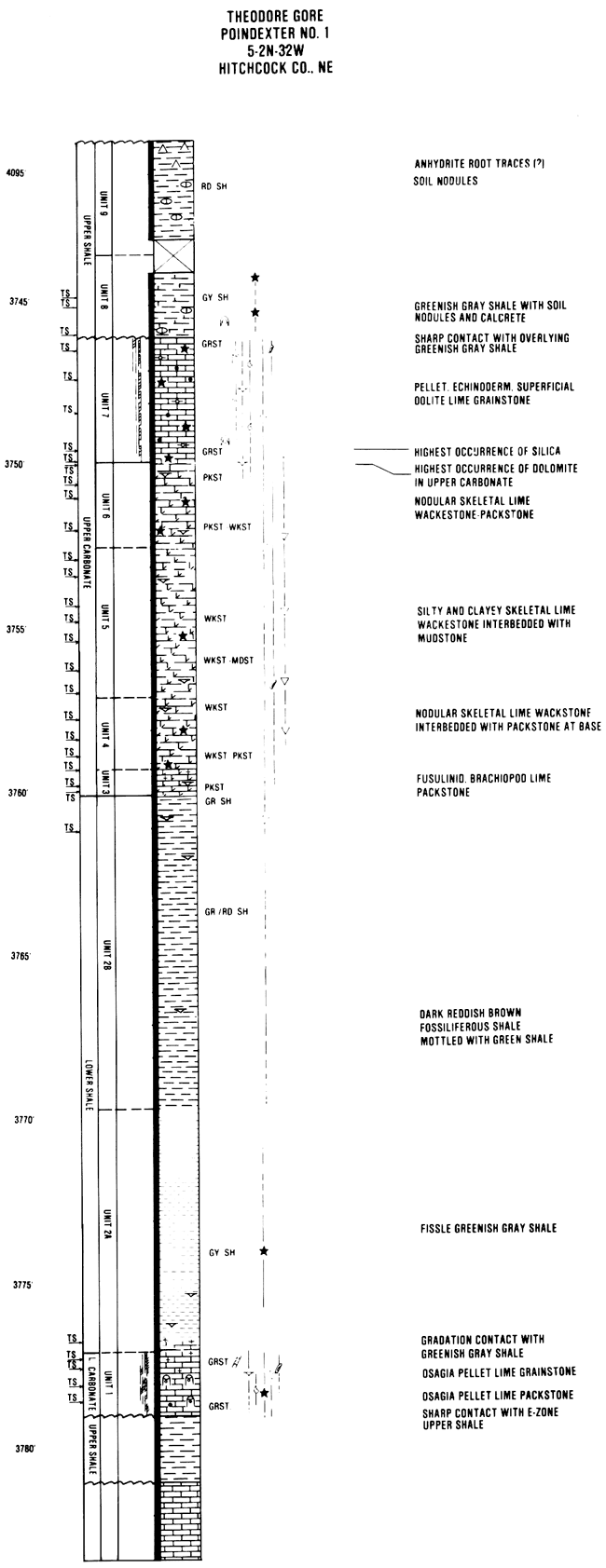
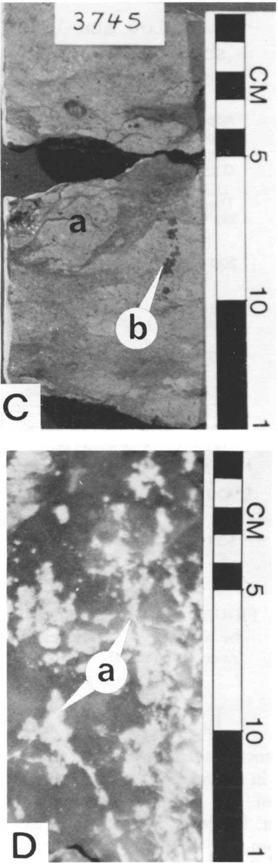
Figure 7--Photomicrographs from selected facies of the D-Zone cyclothem in Poindexter No. 1 core. A) Osagia, pellet grainstone facies from the lower carbonate, 3,778.5 ft.
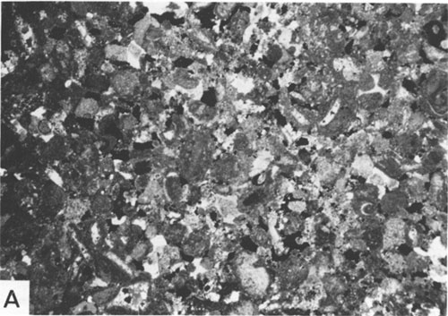
Figure 7B-Portion of Osagia, pellet grainstone with rounded shale clast (a). Note the larger solution-enhanced pores and corroded blocky calcspar cement, 3,777.2 ft.
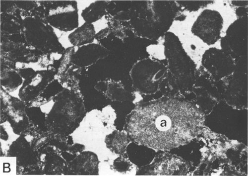
Figure 7C--Fusulinid grainstone facies in upper portion of the lower carbonate. Note the large green algae (Epimastrapora) fragment (a), 3,776.7 ft.
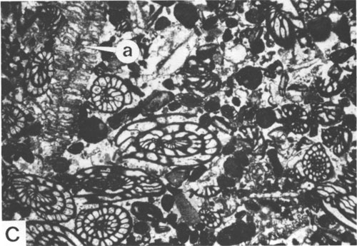
Figure 7D--Broken calcite-healed trilobite fragment from the upper carbonate unit. Note that the calcspar is occluding secondary porosity. The presence of calcspar can greatly reduce porosity locally in the upper interval of the D-Zone 3,748 ft.
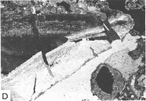
Figure 7E-Pellet, molluscan, crinoid grainstone of the upper interval. Note the syntaxial overgrowths on the crinoid fragments, 3,749.5 ft.
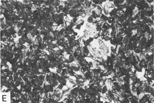
Figure 7F--Pellet, superficial-oolite grainstone is characterized by oolites with single radial calcite coatings surrounding fine-grained nuclei (a) and crinoid fragments (b), 3,647.3 ft. All bar scales are 1 mm.
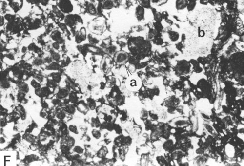
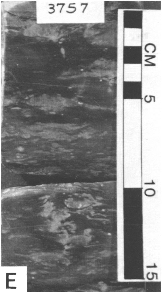
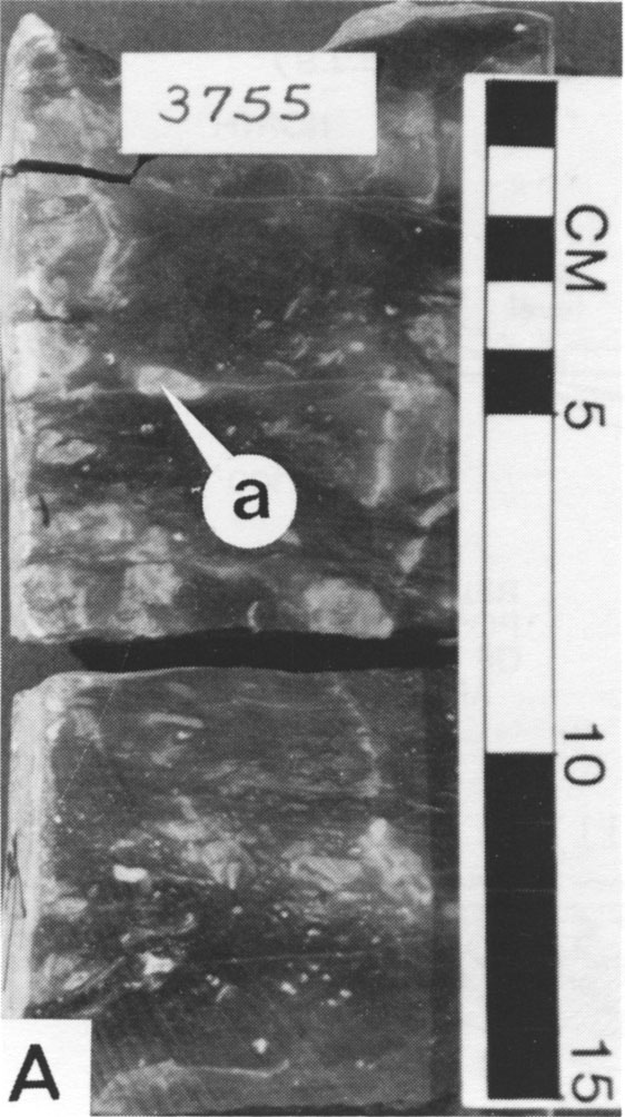
Figure 8--Core slabs from the Poindexter No. 1 D-Zone. A) Large shale clasts (a) reworked from the E-Zone upper shale are easily recognized in core slabs of the D-Zone lower carbonate.
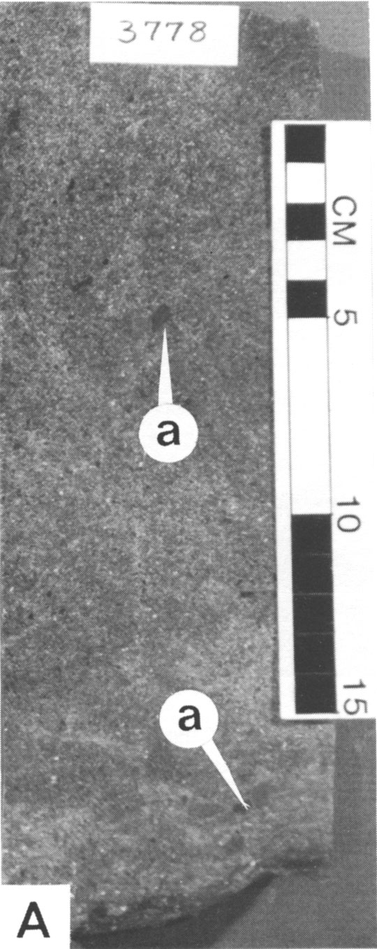
Figure 8B--The lower shale unit is characterized by its dark-red color and scattered fossil fragments such as Rhombopora bryozoan fragments (a).
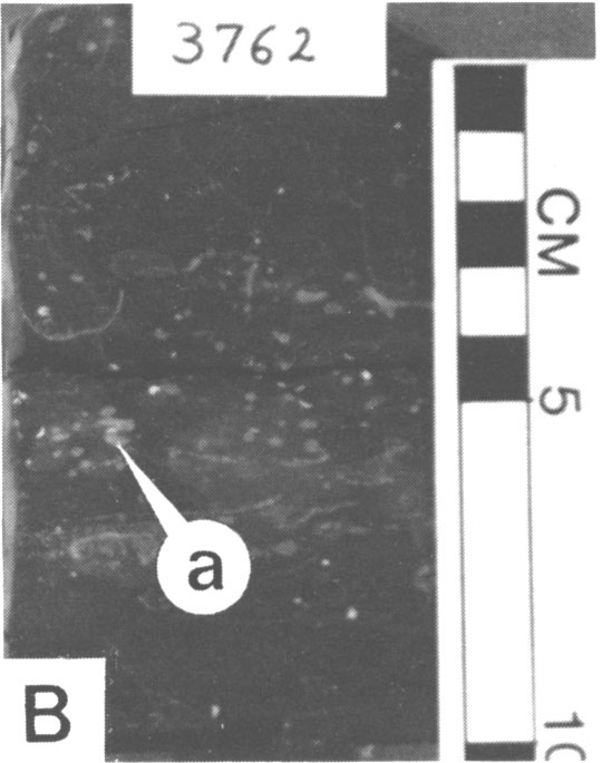
Figure 8C--Unit 3 at the base of the upper carbonate is a very dense skeletal packstone.
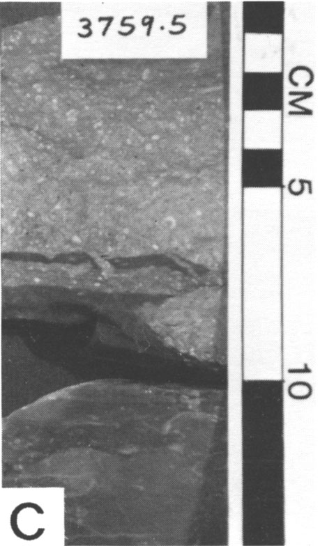
Figure 8D--Overlying unit 3 are the nodular skeletal packstones and wackestones of unit 4.
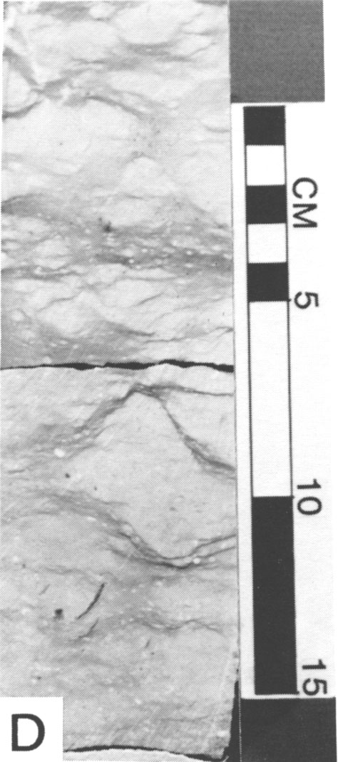
Figure 8E--Unit 5 is characterized by this very argillaceous dusky-red skeletal wackestone and mudstone.
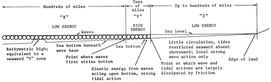
The pellet Osagia grainstone facies represents initial deposition of the lower carbonate in slightly agitated, restricted shallow-marine waters. The overlying pellet fusulinid grainstone facies is a higher-energy, unrestricted marine deposit which accumulated in the study area as the sea level rose. Finally, lime and terrigenous muds containing scattered fusulinids were deposited. This vertical distribution of facies is characteristic of carbonates deposited in epeiric seas during transgression (Elias, 1962; Laporte and Imbre, 1964; Irwin, 1965; Laporte, 1969; Watney, 1979; Heckel et al., 1979; Heckel, 1980; fig. 9).
Figure 9--Irwin's (1965) model for epieric clear-water sedimentation divides the epeiric sea into three energy zones as indicated. The vertical sequence of lithologies in the lower carbonate are interpreted to represent progressive landward migration of these environments during transgression.
The lower carbonate can be readily distinguishable on most wireline log suites. It is characterized by intermediate gamma-ray counts and high neutron counts or low-density values (fig. 10). Locally, where the lower carbonate contains higher percentages of terrigenous clastic material, it has a diminished but usually recognizable log response. Core may be necessary in these areas in order to distinguish log deflections of the lower carbonate from those of similar appearance produced by siltstone beds which occur in the underlying E-Zone upper shale.
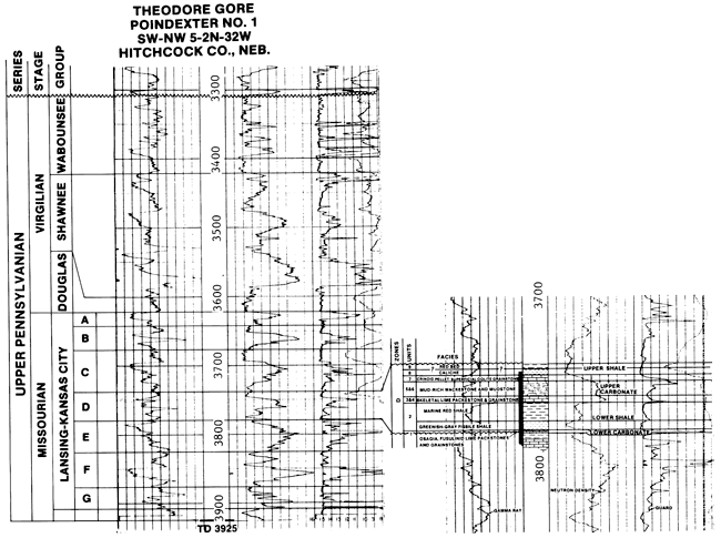
Figure 10--Gamma-ray/neutron-density /guard log from the Poindexter No. 1 showing division of Lansing-Kansas City Groups into individual sedimentary cycles. Detailed subdivisions of the D-Zone is shown to the right.
The lower shale conformably overlies the lower carbonate. It can be divided into two units: 1) a basal greenish-gray fissile shale (unit 2A) and 2) an overlying dark-reddish-brown fossiliferous calcareous claystone (unit 2B; fig. 6).
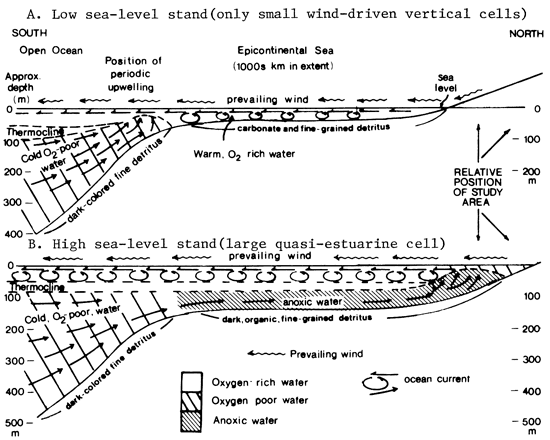
The greenish-gray shale maintains a uniform thickness of 4-6 ft throughout the study area. In the Poindexter No. 1, it contains a limited faunal assemblage of rare brachiopods, echinoderms, and ostracodes. This shale is laterally equivalent to thinner shales with very high gamma-ray "kicks" in southwestern Hitchcock County. This log response is usually associated with black shales. Heckel (1980) noted that gray shale facies of this type may be updip equivalents to more basinal black phosphatic shale facies and probably represent deposition in oxygen-poor environments on the margins of a large anoxic water mass during maximum transgression of sea level in "Kansas-type" cyclothems (fig. 11).
Figure 11--The depositional setting for the black shale facies common in "Kansas-type" cyclothems as proposed by Heckel (1977). The relative position of Hitchcock County on these sections during the accumulation of the D-Zone is indicated.
The gray shale beds can be recognized on gamma-ray/ neutron logs by their intermediate-level gamma-ray, low neutron-density deflections. These log responses should be located directly over the log responses of the lower carbonate bed.
The overlying reddish-brown claystone in the lower shale (fig. 8) thickens northward at the expense of time-equivalent, downdip (southward), massive carbonates to about 18 ft. The claystone must have been deposited very rapidly in order to preserve its red color, in what must have been at least a mildly reducing environment. The dumping of large quantities of detritus on the periphery of the basin probably caused local sea-level regression.
This subfacies can be distinguished from the gray shale facies using gamma-ray/neutron and density logs. It is characterized by lower deflections of the gamma-ray and higher neutron-density deflections (fig. 10).
The upper carbonate is divided into a predominantly mud-supported lower interval and a predominantly grain-supported upper interval.
In the Poindexter No. 1 core, the upper carbonate-lower shale contact is overlain by a clean, thin (6 inches), very dense skeletal packstone (unit 3). This facies is laterally equivalent to skeletal grainstones elsewhere in the study area. Unit 3 was deposited above wave base where the sediments were effectively sorted.
Overlying unit 3 is a nodular skeletal lime packstone-wackestone with numerous wavy laminae (microstylolite swarms) of green clay (unit 4, fig. 8) and dusky-red argillaceous skeletal lime wackestone and mudstone (unit 5, fig. 12). The nodular appearance of these rocks may have been produced through a combination of bioturbation and pressure solution. The presence of an increased percentage of argillaceous material in these facies suggests water turbidity may have increased during their deposition. The turbid water conditions probably resulted in decreased rates of carbonate grain production so that with continued subsidence, lower energy facies of units 4 and 5 migrated into the study area. Solution breccias, although not evident in the Poindexter No. 1 core, are known to commonly occur elsewhere in this interval. The breccias apparently formed during periods of freshwater influx which resulted in dissolution of the limestone. The resulting cavities were later infilled with fragments of the host limestone and red clay and silt deposited by downward-percolating ground water.
Figure 12--Core slabs from the Poindexter No. 1 D-Zone. A) Argillaceous lime mudstone of unit 5. The white areas (a) may be burrows.
B) The basal contact of the upper interval of the upper carbonate is sharp in the Poindexter No. 1. Vuggy and moldic porosity in the overlying upper carbonate is easily recognized in the core slab.
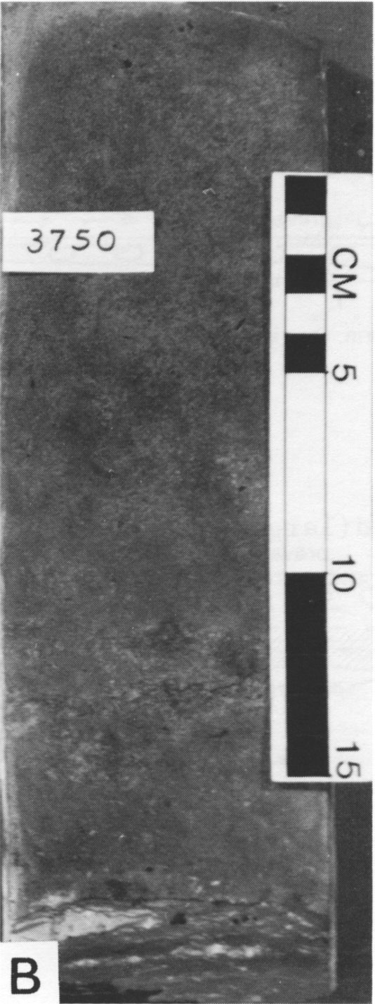
C and D) The basal soil caliche in the upper shale is characterized by caliche nodules (a) and pyrite (b). The uppermost portions of the upper shale locally contain gypsum-filled root molds as illustrated in (D); Ladd Petroleum 2-3A Dry Creek Unit, 4,094-4,095 ft.
The terrigenous influx responsible for deposition of unit 5 eventually waned, allowing for improved water clarity resulting in increased carbonate-grain production. A typical shoaling-upwards sequence resulted as the carbonates built to sea level. This phase of deposition is represented by the packstones and wackestones of unit 6 and the grainstones of unit 7.
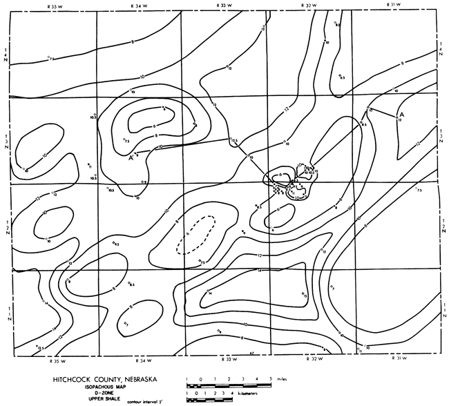
The sharp contact between unit 7 and unit 6 in the Poindexter No. 1 core suggests submarine scouring may have taken place prior to deposition of the pellet, superficial-oolite grainstones in unit 7 (fig. 6). The pellet, superficial oolites were deposited within a shoal-water sand bar which was present in the vicinity of Meeker Canal oil field. The position of this sand bar and others in the study area are revealed as thins on the isopachous map of the upper shale unit of the D-Zone (fig. 13).
Figure 13--Thinning of the upper shale in the D-Zone coincides with localized shoal-water sand bars of the upper carbonate composed of pellet, superficial-oolite grainstones. These sand bars by virtue of their initial porosity were selectively leached during subaerial exposure as undersaturated meteoric water passed through this sediment.
The base of the upper carbonate is easily recognizable on gamma-ray/neutron logs because units 3 and 4 combine to produce the high neutron-density deflection at the base of the upper carbonate. Thickness of the two units as measured in cores corresponds well with the thickness indicated by logs.
The top of the upper carbonate is not always easily distinguished from the upper shale by gamma-ray/neutron/guard or sonic log character. Watney (1980) pointed out that in landward, clastic-dominated areas of the Hugoton embayment, log character contrasts generally become diminished as a result of freshwater diagenesis and in situ brecciation accompanied by clay infiltration within carbonate units. This factor may have an effect on logs from the Poindexter No. 1, where thickness of unit 7 as measured in cores varies slightly with the thickness indicated by the corresponding log traces.
Subfacies of the upper carbonate, other than units 3, 4, and 7, cannot be readily distinguished on wireline logs. However, these rocks can be grouped into a carbonate and terrigenous mud-rich subfacies represented by a slightly greater gamma-ray and reduced neutron-density deflection located between the base of unit 7 and the top of unit 4.
The upper shale in the Poindexter No. 1 was only partially cored. Therefore, the upper portion of the upper shale cored in the Ladd Petroleum Dry Creek Unit 2-3A has been added in order to give complete representation of all typical rock types known to occur in the D-Zone.
The upper shale of the D-Zone in the study area unconformably overlies the upper carbonate. The thickness of the upper shale ranges from 6 to 15 ft and is thought to reflect pre-depositional topography (fig. 13). It can be divided into a basal unit (unit 8) of calcareous, pyritic, greenish-gray claystone which forms a matrix that surrounds rounded limestone clasts, calcrete beds, caliche nodules, and soil nodules. In the Poindexter No. 1 core, however, this unit lacks the limestone clasts and calcrete beds. The claystone matrix is composed of interlocking finely crystalline subhedral calcite and dolomite crystals which produce a crystic plasmic fabric (after Brewer, 1964, p. 37). The presence of this rock type and the other characteristics described above indicate that this unit represents a subsoil caliche similar to those found in many recent and ancient soil weathering profiles (Allen, 1974; Leeder, 1975; Reeves, 1970; Hubert, 1977).
The upper unit (unit 9) is a reddish-brown silty claystone with scattered soil nodules, slickensides, and an uppermost gypsiferous rooted horizon. These characteristics suggest that the upper shale is a paleosol (Hubert, 1977; McPherson, 1979; Wright, 1982; Weider and Yaalon, 1974; Boul et al., 1973).
Both units are easily recognized in core as distinct red and gray units. Nevertheless, the interpretation of these units should not be based solely on their color. Locally, the basal unit which is normally greenish-gray has been reddened. At these locations, remnants of non-reddened greenish-gray crystic Plasmic fabric are commonly preserved on undersides of the regolith limestone clasts. Also, remnants of calcareous and dolomite caliche nodules are present, which suggests this bed may previously have been part of the caliche horizon. The reddening that has taken place at these locations is indicative of secondary oxidation and formation of iron oxides, a process that may have occurred throughout the overlying red-bed unit. The source of the iron oxides probably resulted from intrastratial alteration of iron silicates such as biotite, hornblende, and chlorite similar to that proposed by Walker (1967). This type of reddening is believed to occur in semi-arid to arid climates. Additionally, the preservation of gypsum-filled root molds in the uppermost upper shale is indicative of aridity during soil formation.
The thickness of the upper shale generally corresponds well with the thickness represented on the wireline logs by the distance between the top of the D-Zone (base of C-Zone cyclothem) and the top of the upper carbonate. Resolution of unit 8 within the upper shale on logs generally is not possible. The upper shale is commonly characterized by enlarged borehole conditions as indicated by caliper logs.
Diagenetic features indicative of subaerial exposure abound in the rock of the cyclothem while those indicative of burial and marine diagenesis are considerably less common. Diagenetic fabrics most easily recognized in the core from the Poindexter No. 1 are 1) secondary porosity, 2) silica replacement of skeletal fragments by red chalcedony, and 3) stylolitization.
Porosity in both the upper carbonate and lower carbonate is predominantly secondary, solution enhanced, interparticle, vuggy, and moldic. This porosity was produced by leaching of carbonate grains and cement by freshwater during establishment of freshwater phreatic and vadose environments resulting from subaerial exposure of the carbonate units.
The distribution of the porosity in the D-Zone upper carbonate though is related to the occurrence of shoal-water sand bars. These bars are expressed as thickening of the upper carbonate and relief on its upper surface. Therefore, the isopachous maps of the occurrence of upper-shale thins can be used in the study area to indicate the position of the sand bars. Porosity in the lower carbonate formed as a result of dissolution by freshwater. Controls on the porosity distribution in the lower carbonate are probably related to the flow of freshwater through grain-supported microfacies, lithifying and preserving the porosity in the unit prior to burial.
Limpid rhombic dolomite in the upper carbonate of the Poindexter No. 1 core is scattered throughout the matrix of the lower interval. Although not visible in cores because of its small crystal size, the distribution of this mineral may be an indicator of an important diagenetic event. The characteristics of this dolomite and dolomite cements in the grainstones from nearby wells indicate it probably formed in a mixing zone. A plot of the highest stratigraphic occurrence of the dolomite on a cross section produces a remarkably flat line that transects facies boundaries. This line therefore may represent the highest position of the water table that existed as the mixing zone migrated through the area as sea level fell early in the diagenetic history of the cyclothem. Mixing zones can be indicators of diagenetic environments within which dissolution and porosity development can take place because the ground water in mixing zones is undersaturated with respect to calcite and saturated with respect to dolomite (Plummer, 1975) and its mixing zones are juxtaposed next to undersaturated meteoric freshwaters. Therefore the presence of mixing-zone dolomite, even in nonporous rock, may be a clue that suitable diagenesis has occurred and that porosity may be present elsewhere.
The presence of red, silicified, carbonate skeletal fragments in the D-Zone carbonate units is an important indicator for subaerial exposure. Silica becomes soluble in alkaline soil solutions when the pH rises above 9. Under these conditions, quartz silt and clays can be leached releasing SiO2 in the form of silicic acid or as a colloid (Smale, 1973). Precipitation of the silica takes place at the water table where the downward-percolating silica-laden meteoric water mixes with less-alkaline continental ground waters reducing the pH to below 9. The highest stratigraphic occurrence of red silica in the D-Zone may denote the highest position of the water table during which time grainstones were undergoing vadose leaching. Much of the silica in the D-Zone is in the form of length-slow chalcedony. Length-slow chalcedony may be indicative of silica replacement associated with sulfate enrichment of subsurface waters (Folk and Pittman, 1979), suggesting that ground water during this phase of diagenesis was hypersaline.
During burial, pressure solution in the more terrigenous mud-rich facies combined with earlier bioturbation to produce the common nodular appearance of those rocks. Recognition of the origin of the nodular limestones is important in classification of the upper carbonate subfacies.
Detailed examination of core aids in understanding depositional processes that were operating in the Late Pennsylvanian seas of the western Midcontinent. Understanding these processes allows for development of depositional models which can aid in predicting the distribution of the grain-supported rock necessary to form reservoir rocks.
Recognition of certain diagenetic features such as solution breccias, red silica-replaced skeletal fragments, and mixing-zone dolomites in nonporous upper carbonate sections aids in documenting and characterizing the diagenetic environments which resulted in the development of secondary porosity affecting the zone of interest.
Allen, J. R. L., 1974, Sedimentology of the Old Red Sandstone (Siluro-Devonian) in the Clee Hill area, Shropshire, England: Sedimentological Geology, v. 12, p. 63-67.
Boul, S. W., Hale, F. D., and McCraken, R. J., 1973, Soil genesis and classification: Ames, Iowa, Iowa State University Press, 360 p.
Branson, C. C., 1961, Pennsylvanian System of the Midcontinent; in, Pennsylvanian System in the United States—a symposium, by C. C. Branson, ed.: American Association of Petroleum Geologists, p. 431-460.
Brewer, R., 1964, Fabric and mineral analysis of soils: New York, Wiley, 470 p.
Burchett, R. R., 1983, Surface to subsurface correlation of Pennsylvanian and Lower Permian rocks across southern Nebraska: Nebraska Geological Survey, Report of Investigations No. 8, p. 24.
Dubois, M. K., 1979, Factors controlling the development of porosity in the Lansing-Kansas City "E" Zone, Hitchcock County, Nebraska: University of Kansas, M.S. thesis.
Elias, G. K., 1962, Paleoecology of Lower Pennsylvanian bioherms, Paradox basin, Four Corners area; in, Geoeconomics of Pennsylvanian Marine Banks in Southern Kansas: Kansas Geological Society, 27th Field Conference, p. 124-128.
Folk, R. L., and Pittman, J. S., 1979, Length-slow chalcedony-a new testament for vanished evaporites; in, Silica in Sediments--Nodular and Bedded Chert: Society of Economic Paleontologists and Mineralogists, Reprint Series No. 8, p. 59-72.
Heckel, P. H., 1977, Origin of phosphatic black shale facies in Pennsylvanian cyclothems of Midcontinent North America: American Association of Petroleum Geologists, Bulletin, v. 61, no. 7, p. 1,045-1,068.
Heckel, P. H., 1980, Paleogeography of eustatic model for deposition of Midcontinent Upper Pennsylvanian cyclothems; in, Paleozoic Paleogeography Symposium 1, T. D. Fouch and E. R. Magathan, eds.: Rocky Mountain Section, Society of Economic Paleontologists and Mineralogists, p. 197-216.
Heckel, P. H., Brady, L. L., Ebanks, W. J., Jr., and Pabian, R. K., 1979, Pennsylvanian cyclic platform deposits of Kansas and Nebraska: Kansas Geological Survey, Guidebook Series No. 4, p. 8-21. [available online]
Hubert, J. F., 1977, Paleosol caliche in the New Haven Arkose, Connecticut--record of semiaridity in the Late Triassic-Early Jurassic time: Geology, v. 5, p. 302-304.
Irwin, M. L., 1965, General theory of epeiric clear-water sedimentation: American Association of Petroleum Geologists, v. 49, no. 4, p. 445-459.
Laporte, L. F., 1969, Recognition of a transgressive carbonate sequence within an epeiric sea--Helderberg Group (Lower Dekonian) of New York state; in, Depositional Environments in Carbonate Rocks, G. M. Friedman, ed.: Society of Economic Paleontologists and Mineralogists, Special Publication No. 14, p. 98-118.
Laporte, L. F., and Imbrie, J., 1964, Phases and facies in the interpretation of cyclic deposits: Kansas Geological Survey, Bulletin 169, p. 249-363. [available online]
Leeder, M. R., 1975, Pedogenic carbonates and flood-plain sediment accretion rates--a quantitative model for alluvial arid-zone lithofacies: Geology Magazine, v. 112, p. 257-270.
McPherson, J. G., 1979, Calcrete (caliche) paleosols in fluvial red beds of the Aztec Siltstone (Upper Devonian), southern Victoria Land, Antarctica: Sedimentological Geology, v. 22, p. 267-285.
Merriam, D. F., 1954, Structural development of the Hugoton embayment: Kansas Geological Survey, Proceedings of the 4th Subsurface Geological Symposium, p. 81-97.
Merriam, D. F., and Atkinson, W. R., 1955, Tectonic history of the Cambridge arch in Kansas: Kansas Geological Survey, Oil and Gas Investigations No. 13. [available online]
Moore, R. C., 1929, Environment of Pennsylvanian life in North America: American Association of Petroleum Geologists, Bulletin, v. 13, no. 5, p. 459-487.
Parker, J. M., ed., 1961, Oil and gas fields, Colorado-Nebraska: Rocky Mountain Association of Geologists.
Parkhurst, R. W., 1959, Surface to subsurface correlations and oil entrapment in the Lansing-Kansas City Groups (Pennsylvanian) in northwestern Kansas: M.S. thesis, University of Kansas.
Rascoe, B., Jr., 1962, Regional stratigraphic analysis of Pennsylvanian and Permian rocks in western Midcontinent, Colorado, Kansas, Oklahoma, and Texas: American Association of Petroleum Geologists, Bulletin, v. 46, no. 8, p. 1,345-1,370.
Rascoe, B., Jr., 1978, Late Paleozoic structural evolution--the Las Animas arch; in, Energy Resources of the Denver Basin: Rocky Mountain Association of Geologists, 1978 Symposium, p. 113-127.
Reeves, C. C., Jr., 1970, Origin, classification, and geologic history of caliche on southern High Plains, Texas, and eastern New Mexico: Journal of Geology, v. 78, p. 352-362.
Smale, D., 1973, Silcretes and associated silica diagenesis in southern Africa and Australia: Journal of Sedimentary Petrology, v. 43, no. 4, p. 1,077-1,089.
Swanson, R. G., 1981, Sample examination manual: American Association of Petroleum Geologists, Methods in Exploration Series, p. 118-121.
Walker, T. R., 1967, Formation of red beds in modern and ancient deserts: Geological Society of America, Bulletin, v. 78, p. 353-368.
Watney, W. L., 1979, Gamma ray-neutron cross plots as an aid in sediment analysis; in, Geomathematical and Petrophysical Studies in Sedimentology, Computers, and Geology, vol. 3, D. Gill and D. F. Merriam, eds.: Oxford, Pergamon Press, p. 81-100.
Watney, W. L., 1980, Cyclic sedimentation of the Lansing-Kansas City Groups in northwestern Kansas and southwestern Nebraska: Kansas Geological Survey, Bulletin 220, 70 p. [available online]
Wieder, M., and Yaalon, D. H., 1974, Effect of matrix composition on carbonate nodule crystallization: Geoderma, v. 11, p. 95-12 1.
Wright, V. P., 1982, Calcrete paleosols from the Lower Carboniferous Llaney formation, South Wales: Sedimentary Geology, v. 33, p. 1-33.
Kansas Geological Survey
Comments to webadmin@kgs.ku.edu
Web version April 16, 2010. Original publication date 1985.
URL=http://www.kgs.ku.edu/Publications/Bulletins/Sub6/Prather/index.html