Kansas Geological Survey, Subsurface Geology 6, p. 161-171
by
Talat Y. Abdullah
Kansas Geological Survey
An Acrobat PDF file containing the complete paper is available (728 kB).
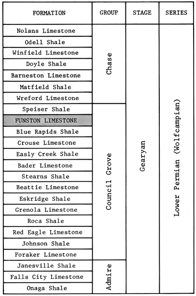
The Council Grove Group (Lower Permian) of southwestern Kansas consists of alternating strata of shale and limestone. The Funston Formation, lying under the Speiser Shale (fig. 1), is one of the major gas-producing zones in the Panoma gas area of the Hugoton embayment.
The principle objective of this paper is to interpret the depositional environments of the lithofacies that comprise the Funston cycle in the subsurface of southwestern Kansas.
Figure 1--Stratigraphic position of rocks of the Lower Permian (Wolfcampian) Series in Kansas (Zeller, 1968).
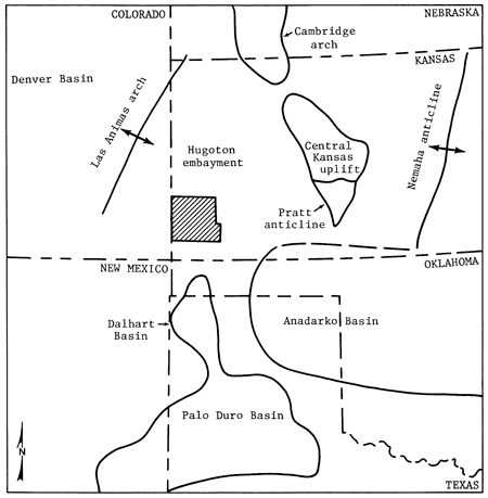
The study area is located in the Hugoton embayment of southwestern Kansas (fig. 2). The embayment, described by Merriam (1963) as a northern shelflike extension of Oklahoma's Anadarko Basin, covers parts of Kansas, Colorado, Oklahoma, and Texas. The eastern side of the embayment is formed by the Pratt anticline, the Central Kansas uplift, and the Cambridge arch (fig. 3). The western limit is formed by the Las Animas arch of Colorado. The Hugoton embayment plunges southward, and sedimentary strata thicken both toward the axis of the embayment and southward into the Anadarko Basin of southwestern Oklahoma (Merriam and Goebel, 1968).
Figure 2--Study area (top) in southwestern Kansas shows locations of the cored wells used in thesis study (Abdullah, 1983), as well as the Anadarko #C-1 Rhinehart Estate of Stevens County. The Kansas map (bottom) shows relation of the study area to the Panoma gas area and the outcrop belt of upper Council Grove Group rocks in eastern Kansas.
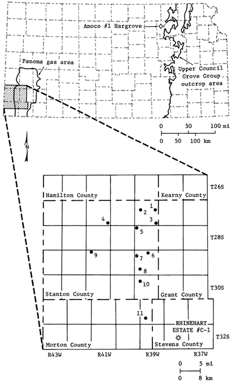
Figure 3--Major tectonic elements of Kansas and adjacent areas in Late Pennsylvanian and Early Permian time.
Downwarping in the general area of the embayment began during the Precambrian and continued through much of the Paleozoic. This was interrupted periodically by broad epeirogenic uplift. Deposits during the Cambrian were formed by transgressing seas initiating a long history of sediment accumulation. In the Late Paleozoic regional transgressions and regressions caused accumulation of cyclic marine and nonmarine strata (Merriam, 1956). Most of the structural features that originated during the Pennsylvanian remained active during the Permian. Prominent features such as the Nemaha anticline, the Central Kansas uplift, the Las Animas arch, and the Hugoton embayment existed during the deposition of Early Permian deposits (Mudge, 1967). Post-Paleozoic deposits mask the structure of the underlying Paleozoic strata. Structural development of the embayment was concluded by the close of the Permian, and the structure of the Late Paleozoic strata is, therefore, not reflected in the overlying younger strata (Merriam, 1963).
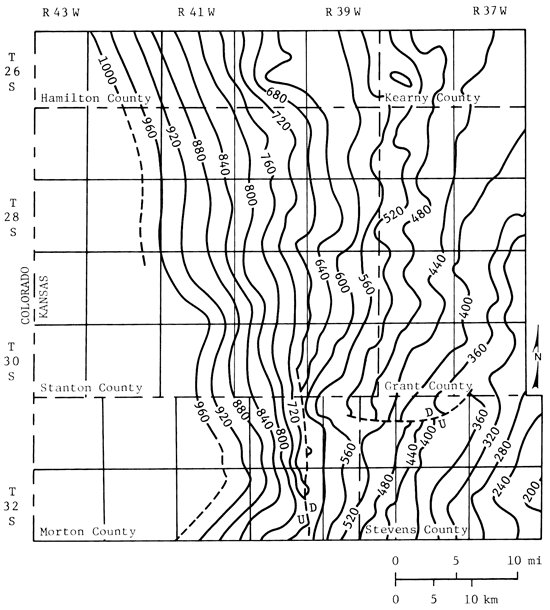
Currently, the structure of the top of the Council Grove Group in the study area is monoclinal (fig. 4). The dip is east-southeast with a magnitude of 20 ft/mi (3.75 m/km).
Figure 4--Structural contour map, top of Council Grove Group; contour interval = 40 ft.
The Wolfcampian (Lower Permian) in southwestern Kansas consists of the Chase, Council Grove, and Admire groups (fig. 1). These groups mainly are composed of alternating shale and limestone units that are traceable for long distances to the outcrop area in eastern Kansas (Mason, 1968). The units exhibit cyclic patterns similar to those in Upper Pennsylvanian deposits (Jewett, 1933, in Merriam, 1963). Mason (1968) remarked that westward toward the Las Animas arch (fig. 3), the limestone and dolomite beds of the Chase Group grade laterally into red sandstones and siltstones.
The Lower Permian strata are conformably overlain by a sequence of shale, siltstone, and sandstone, most of which is red and interbedded locally with thick deposits of evaporites and dolomite (Merriam, 1963).
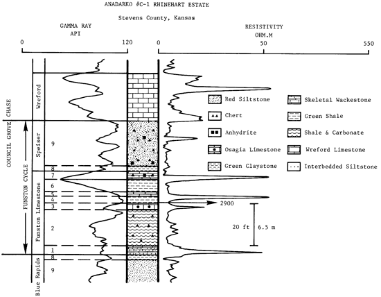
Based on detailed examinations of cores and thin sections from 11 wells from the study area (fig. 2), in a study made by Abdullah (1983), major lithofacies that comprised the Data for map are from Merriam (1963), Dixon (1967), and Mudge (1967). Funston cycle were recognized, and their depositional environments were interpreted. Most of the features described in the thesis study can be observed in the core samples from the Anadarko # C-1 Rhinehart Estate, NE SE SW, sec. 22, T. 32 S., R. 38 W., Stevens County, Kansas. The various lithofacies are summarized in fig. 5 and are described below.
Figure 5--Gamma ray-resistivity well-log signature of the Anadarko #C-1 Rhinehart Estate, NE SE SW, sec. 22, T. 32 S., R. 38 W., Stevens County, Kansas. Depositional facies comprising the Funston cycle are indicated.
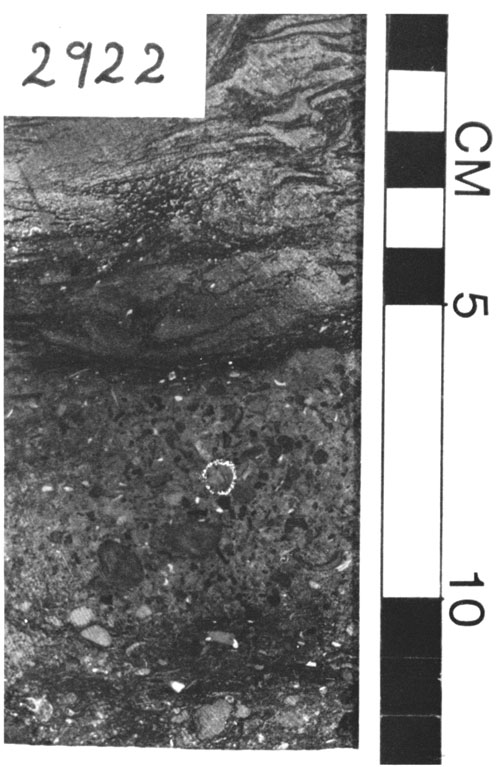
Lithofacies 1 is the lowermost carbonate unit in the cycle. It is dark gray and is usually a wackestone (fig. 6). The thickness is 4 ft (1.2 m; 2,918-2,922 ft on the slabbed core). The wackestone is composed of fine- to coarse-grained, subrounded bioclasts of crinoids, brachiopods, mollusks, and ostracodes. Algal-coated grains and intraclasts also are abundant. The skeletal wackestone is interbedded with nonfossiliferous siltstone in the lower part of the unit. The upper contact of lithofacies 1 is gradational, whereas the lower contact is erosional and marks the regional transgression in the Funston cycle.
Figure 6--Core slab of base of lithofacies 1 (2,922 ft; Anadarko #C-1 Rhinehart Estate). Silty mixed-skeletal wackestone; black areas probably are algal-coated grains. Scale is in centimeters.
The upper interval of the unit is shaly and grades upward into dark-gray to black shale. Little diagenesis has occurred so that the original texture is generally well preserved. Porosity in the unit is usually very low.
Lithofacies 1 probably was deposited during the initial stages of transgression in a shallow, restricted intertidal environment that was interrupted by deposition of terrigenous clastic siltstones. The remaining part of the unit (upper interval) was formed in a low-energy, subtidal-marine environment.
Lithofacies 2 consists largely of dark-gray to black shale beds with siltstone and carbonate intervals in the lower half of the unit. Total thickness of the unit is 20 ft (6.5 m; 2,898-2,918 ft on the slabbed core). The shale is massive, calcareous, fractured, and fossiliferous. Fossils are diverse and include brachiopods, crinoids, bryozoans, and ostracodes. Most of the fossil fragments either are completely or partially silicified. The upper contact is sharp, whereas the lower contact is gradational.
The limestone interval is about 1.5 ft (0.5 m) thick (2,909.5-2,911 ft on the slabbed core). It is a dark-gray, shaly, burrowed, skeletal wackestone. Fossils include brachiopods, crinoids, and bryozoans. Most of the fossil fragments are silicified.
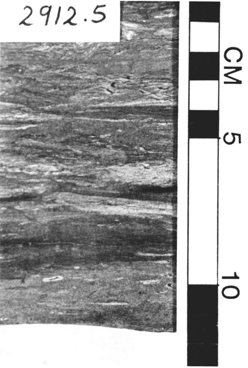
The siltstone bed interval is about 3 ft (1 m) thick (2,911-2,914 ft on the slabbed core). The siltstones are shaly and exhibit ripple laminations (fig. 7).
Figure 7--Core slab of lower interval of lithofacies 2 (2,912.5 ft; Anadarko #C-1 Rhinehart Estate). Ripple-laminated siltstone. Scale is in centimeters.
Beds of lithofacies 2 were formed during an influx of terrigenous sediments (except for a less turbid period marked by the deposition of the skeletal wackestone bed) into a subtidal-marine environment.
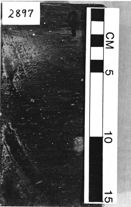
This carbonate unit is dark, mottled-gray mixed skeletal wackestone (fig. 8). It is 1 ft (0.3 m) thick (2,897-2,898 ft on the slabbed core). The lower part of the lithofacies consists of Osagia wackestone with fossil fragments such as crinoids and bivalves. The upper part is a burrowed, argillaceous skeletal wackestone. The upper contact is gradational, whereas the lower contact is erosional and probably marks a minor transgression.
Figure 8--Core slab of upper interval of lithofacies 3 (2,897 ft; Anadarko #C-1 Rhinehart Estate). Argillaceous mixed-skeletal wackestone. Scale is in centimeters.
The basal part of lithofacies 3 was deposited in a moderate-energy, shallow-water subtidal to lower intertidal marine environment. The remaining part of the unit was formed in a turbid, low-energy subtidal-marine environment.
Lithofacies 4 is a green to greenish-gray, massive, calcareous shale unit. It is 3 ft (1 m) thick (2,894-2,897 ft on the slabbed core). The shale is silty and fossiliferous. Brachiopods, crinoids, and ostracodes dominate the fossil assemblages in the unit. Chert nodules and silicified fossil fragments are common. The upper and lower contacts are gradational.
Lithofacies 4 was formed in a low-energy, turbid, subtidal-marine environment. The high-silt proportion and generally lighter color that characterize this unit indicate a shallower subtidal environment than that of the underlying shale beds of lithofacies 2.
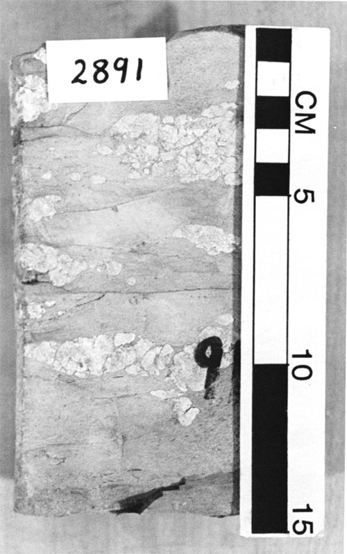
Lithofacies 5 is a gray, argillaceous mixed-skeletal wackestone. The thickness is about 2.25 ft (0.7 m; 2,891.75-2,894 ft on the slabbed core). Fossils include crinoids, brachiopods, bryozoans, and ostracodes. Most of the fossil fragments either are partially or completely replaced by silica. Chert blebs and burrows are common in this unit.
This unit was deposited primarily in a low-energy, shallow-water, subtidal environment. Abundance of quartz silt and clay suggests turbidity at the site of sedimentation.
This lithofacies consists of green to greenish-gray shale beds. Its thickness is about 5.75 ft (1.75 m; 2,886-2,891.75 ft on the slabbed core). The shale is silty and fossiliferous with abundant chert nodules (fig. 9). Both the lower and upper contacts are gradational. The unit probably was formed in an environment similar to that of rocks of lithofacies 4.
Figure 9-Core slab of lithofacies 6 (2,891 ft; Anadarko #C-1 Rhinehart Estate). Silty fossiliferous shale with chert nodules. Scale is in centimeters.
Lithofacies 7 consists of carbonate rocks that occupy the uppermost part of the Funston Formation. The color varies from light gray to tan. Its thickness is 4 ft (1.2 m; 2,882-2,886 ft on the slabbed core). The lower contact is gradational, whereas the upper contact is erosional and marks the regional regression.
The lower interval of the unit (2,885-2,886 ft) is a light-gray, argillaceous, mollusk wackestone. Color becomes lighter and terrigenous clay and silt content decrease upward in the interval (2,883.5-2,885 ft). Fossils and fossil fragments are abundant and include brachiopods, crinoids, echinoids, mollusks, bryozoans, and ostracodes. The texture is generally wackestone.
Diversity of fossils decreases upward in the interval (2,882-2,883.5 ft). The texture is a packstone (fig. 10). This upper interval consists largely of algal-coated grains with crinoid and echinoid fragments. Anhydrite and silica replacements are common. The uppermost part of lithofacies 7 (1.5 inches thick) is a dolomudstone interbedded with terrigenous red siltstone.
Figure 10--Core slab of upper interval of lithofacies 7 (2,882 ft; Anadarko #C-1 Rhinehart Estate). Crinoid, coated-grain packstone. Scale is in centimeters.
Rocks of the lower interval (2,883.5-2,886 ft) were deposited in a low-energy, shallow, subtidal-marine environment, whereas those of the upper interval (2,8822,883.5 ft), except the dolomudstones, were formed in a restricted intertidal environment. The uppermost dolomudstone bed probably was formed on a supratidal flat.
Lithofacies 8 is a green, structureless, nonfossiliferous claystone. Its thickness is about 2 ft (0.6 m; 2,880.2-2,882 ft). The unit is characterized by an erosional upper contact and a gradational lower contact where it underlies the Funston Formation, whereas its lower contact is erosional and the upper contact is gradational where it caps the Funston Formation. Anhydrite and chert nodules are common in this lithofacies.
Claystones of this unit probably are fluvial deposits. Hanford and Fredericks (1980) described similar rocks in the Palo Duro Basin of the Texas panhandle and suggested that the claystones were formed in a mud-rich coastal sabkha. Terrigenous sediments were transported by rivers into the sabkha flat.
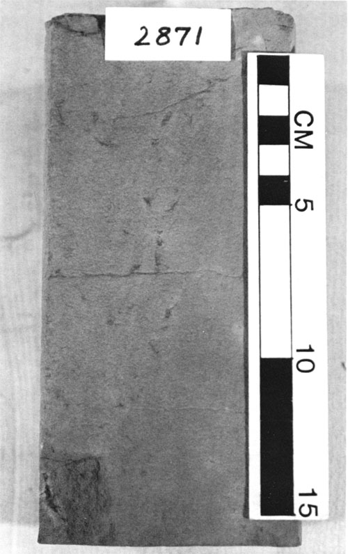
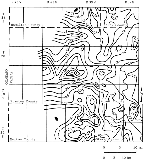
Lithofacies 9 consists of reddish-brown, very fine-grained sandstones and siltstones interbedded with green siltstones (fig. 11). The thickness is about 22 ft (8 m; 2,858-2,880.2 ft). Generally the thickness is greater in the northwestern and southwestern parts of the study area (figs. 12, 13, and 14). Arrows on fig. 14 indicate the probable direction of sediment transportation.
Figure 11--Core slab of siltstones of lithofacies 9 (2,871 ft; Anadarko #C-1 Rhinehart Estate). Fractured red, calcareous siltstone. Scale is in centimeters.
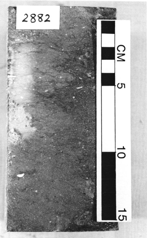
Figure 12--West-east subsurface stratigraphic cross section in southwestern Kansas; datum is top of the Council Grove Group. Inset map shows location of cross section line.
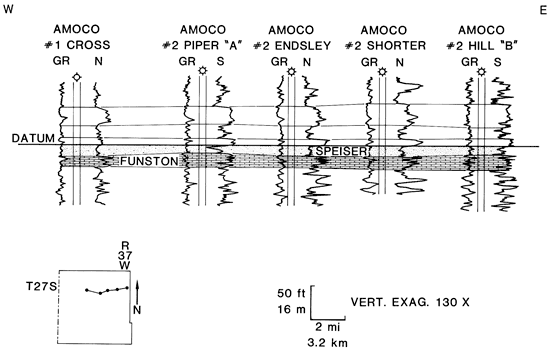
Figure 13--South-north subsurface stratigraphic cross section in southwestern Kansas; datum is top of the Council Grove Group. Inset map shows location of cross section line.
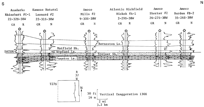
Figure 14--Isopach of the Speiser Formation; contour interval = 2 ft.
Lithofacies 9 overlies the Funston Formation and is located between two beds of lithofacies 8. Chaotic fractures and lath-shaped crystals of anhydrite are common in this unit, particularly in the lower interval. Gypsum probably was precipitated first and later was replaced by anhydrite. Similar events were reported from the modern sabkhas of the Trucial coast (Bathurst, 1975).
The siltstones of the Speiser Formation are similar to those of the Red Cave Formation of the Palo Duro Basin. Hanford and Fredericks (1980) suggested that the sandstones and siltstones of the Red Cave are fluvial or fluvial deposits reworked by the wind.
Terrigenous sediments in the upper half of the Council Grove Group and in the Chase Group along the Las Animas arch probably were derived from south-central Colorado (Mudge, 1967).
The various lithofacies comprising the Funston cycle were formed in a wide range of environments that included shelf lagoons with open circulation, restricted lagoons, tidal flats, and sabkhas. A summary of the events that occurred in southwestern Kansas during deposition of the Funston sediments are listed below.
With the continuing fall of sea level, terrigenous sediments were deposited near the shoreline. The top of lithofacies 7 is capped by green unfossiliferous claystones of lithofacies 8. Upward the claystones grade into red beds. The red beds might have formed either by fluvial processes or by eolian reworking of fluvial deposits.Thick accumulations of the terrigenous rocks commonly overlie thin beds that belong to the regressive carbonate unit (see fig. 12). This suggests that environments of deposition were shifted east- southeastward (seaward) during the regional regression.The poor development of evaporites at the top of lithofacies 7 is attributed to the lack of interruption in sedimentation of the prograding red beds. Anhydrite and caliche nodules are common in the red beds, however, suggesting semi-arid climate similar to that of recent sabkhas along the Abu Dhabi coast of the Arabian Gulf.
The Pennsylvanian cyclic strata of the Lansing and Kansas City Groups in western Kansas were probably deposited during periods of semi-arid climatic conditions (Watney, 1980). Anhydrite development in the regressive carbonate strata of these groups has not been documented. However, Prather (1981) reported the presence of nodular anhydrite in a later-stage regressive shale in the D-Zone cyclothem (Lansing-Kansas City Groups) from southwestern Nebraska. This indicates that and climatic conditions prevailed in areas north of the Hugoton embayment during the deposition of the Pennsylvanian cyclothems. On the other hand, bedded anhydrite in the younger Nolans Limestone (Upper Wolfcampian) was reported by Glossa (1982). Mudge (1967) indicated that climate became more and at the close of the Wolfcampian. The Funston Limestone, therefore, probably was deposited during a transitional period from semi-arid to and climatic conditions.
In summary, a rapid regional transgression followed by a slow, continuous regression was responsible for the deposition of the Funston-cycle sediments. Interbedded carbonate and shale beds can be explained by the occurrence of both minor transgressions and regressions within the cycle. Faunal and lithologic variations within the shoaling lithofacies 7 further support the idea of sea-level fluctuation.
Abdullah, T. Y., 1983, Depositional environments and porosity development in the Funston Limestone (Lower Permian), southwestern Kansas: M.S. thesis, University of Kansas, 140 p.
Bathurst, R. G. C., 1975, Carbonate sediments and their diagenesis--developments in sedimentology: Amsterdam, Elsevier, v. 12 (2nd ed.), 658 p.
Dixon, G. H., 1967, Paleotectonic investigations of the Permian System in the United States, northwestern New Mexico and Texas-Oklahoma panhandles: U.S. Geological Survey, Professional Paper 515, p. 65-80. [available online]
Glossa, J. M., 1982, Depositional environments and diagenetic history of the Nolans Limestone (Upper Wolfcampian), Rice County, Kansas: M.S. thesis, University of Kansas, 30 p.
Hanford, C. R., and Fredericks, P. E., 1980, Facies patterns and depositional history of a Permian sabkha complex-Red Cave Formation, Texas panhandle: University of Texas (Austin), Bureau of Economic Geology, Circular 80-9, 38 p.
Jewett, J. M., 1933, Evidence of cyclic sedimentation in Kansas during the Permian Period: Kansas Academy of Science, Transactions, v. 36, p. 137-140.
Mason, J. W., 1968, Hugoton Panhandle field, Kansas, Oklahoma, and Texas; in, Natural Gases of North America, B. W. Beebe, ed.: American Association of Petroleum Geologists, Memoir 9, v. 2, p. 1,539-1,547.
Merriam, D. F., 1956, Hugoton embayment commands fresh look: Oil and Gas Journal, v. 54, no. 44, p. 82-86.
Merriam, D. F., 1963, The geologic history of Kansas: Kansas Geological Survey, Bulletin 162, 317 p. [available online]
Merriam, D. F., and Goebel, E. D., 1968, Natural gas in Kansas, A) occurrence of natural gas in Kansas; in, Natural Gases of North America, B. W. Beebe, ed.: American Association of Petroleum Geologists, Memoir 9, v. 11, p. 1,548-1,557.
Mudge, M. R., 1967, Paleotectonic investigations of the Permian System in the United States, central Midcontinent region: U.S. Geological Survey, Professional Paper 515, p. 97-123. [available online]
Prather, B. E., 1981, Petrology and diagenesis of the D-Zone cyclothem of the Lansing-Kansas City Groups, Hitchcock County, Nebraska: M.S. thesis, University of New Orleans, 97 p.
Watney, W. L., 1980, Cyclic sedimentation of the Lansing-Kansas City Groups in northwestern Kansas and southwestern Nebraska: Kansas Geological Survey, Bulletin 220, 72 p. [available online]
Zeller, D. E., ed., 1968, The stratigraphic succession in Kansas: Kansas Geological Survey, Bulletin 189, 81 p. [available online]
Kansas Geological Survey
Comments to webadmin@kgs.ku.edu
Web version April 19, 2010. Original publication date 1985.
URL=http://www.kgs.ku.edu/Publications/Bulletins/Sub6/Abdullah/index.html