Kansas Geological Survey, Subsurface Geology Series 10, originally published in 1988
Originally published in 1988 as Kansas Geological Survey Subsurface Geology Series 10. This is, in general, the original text as published. The information has not been updated. An Acrobat PDF file containing the complete report is available (2.5 MB). Plate 1 is in a separate file.
Petroleum exploration in the Salina basin in north-central Kansas (Lee, 1956) has met with limited success to date. Except for in its extreme southern end in McPherson and Saline counties and its eastern flank in Clay County, the basin has had no fields discovered in over 60 years of drilling. The failure to find significant reserves in the Salina basin no doubt discourages all but the boldest explorationist. Exploration test wells have been drilled infrequently, and consequently large areas encompassing almost entire counties remain untested. The Salina basin is therefore one of the least-known areas in Kansas with respect to its petroleum potential.
The Salina basin may never be a prolific petroleum province; nevertheless, it could contain oil and gas fields which could be economic and interesting to small oil companies and local communities. The Forest City basin in northeast Kansas is geologically similar in many ways to the Salina basin (Lee, 1956). Many small oil and gas fields are present in the Forest City basin and still more are being discovered. Similar types of fields are therefore possible in the Salina basin.
Wildcatters prospecting for petroleum in areas far from known oil fields must do everything possible to maximize their chances for success. At the same time, they must conserve their expenses in what could be a costly drilling program if no reserves are found. In areas such as the Salina basin, where widely spaced wells limit the amount of geologic control available, gleaning as much information as possible from each well is very important. Hydrocarbon shows that have been logged in previously drilled wells represent a potentially important source of information.
Oil and gas shows per se are not proof that commercial quantities of petroleum will be discovered, but they do indicate where geologic conditions favorable for petroleum formation were fulfilled, if only to a small degree. When used in conjunction with other geologic data, hydrocarbon shows (or the lack of them) can be useful in assessing the petroleum potential of individual prospects or entire basins. Thus, exploration dollars can be spent more wisely if hydrocarbon shows are taken into account.
This data search was initiated in December 1985, to ascertain if any petroleum shows are present in wells drilled in the Salina basin, and, if so, to determine where these shows are concentrated and which stratigraphic horizons generate them. The data sources used in this compilation are available in the Minerals Information Center at the Kansas Geological Survey in Lawrence, Kansas. Three types of source documents were queried for the 1,224 wells in the study area-scout cards, driller's logs, and lithologic-strip logs. Other sources of information such as geologic reports available in the library of the Kansas Geological Society in Wichita may yield additional data but were not included in this report.
The following information was gathered about each show: operator and well name, spot location, county, completion date, surface datum, depth interval, formation, and type of show. The type of show is described using the comments contained in the original source document. Abbreviated oil-field terms are the descriptors commonly used in characterizing these shows [e.g., SSO (slight show oil), OCM (oil-cut mud), GCM (gas-cut mud), etc.]. Wherever possible in this report, the show description is conveyed verbatim from the source document, with perhaps only minor changes in spelling. A glossary of the stratigraphic abbreviations and oil-field terms used in this report (appendix 1) precedes the compilation of hydrocarbon shows (appendix 2).
The shows are separated into three groups according to the nature of the source document (scout card, driller's log, lithologic log). Within each group, shows are separated into those present in the west ranges versus those in the east ranges. Within this hierarchy, wells are filed according to their location by township, range, and section. Shows reported in documents other than scout cards, driller's logs, and lithologic logs are reported at the end of the compilation for the west ranges. Areas close to existing oil fields were ignored by excluding any oil shows found within the quarter-township containing a known oil or gas field, or segment of a field.
The number and distribution of oil shows are, in part, a function of the number and location of wells drilled in the basin. The distribution of dry holes and oil fields within the Salina basin is shown on the map accompanying this report (figure 1; in back pocket). Other information, such as total depth and deepest formation penetrated by each well, are not included. Factors such as experience and alertness of the observer of course cannot be estimated.
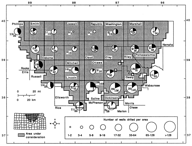
Figure 2 is based on figure 1 and graphically summarizes oil shows and drilling density for several subdivisions of the Salina basin. In this figure, the interior of the basin is divided into several subdivisions. Each subdivision is approximately four by four townships (approximately 575 mi2; 1,490 km2) , except where smaller subdivisions were used along the periphery of the study area. The relative number of wells and oil shows in different parts of the basin easily can be compared by inspection of pie charts that summarize drilling in each subdivision.
Figure 2--Summary of oil shows in Salina Basin. Percentage of wells in given area reporting oil shows shown as dark wedge (also expressed as a ratio).
The number of petroleum shows within this relatively nonproductive basin is surprising. In the west ranges over the deepest part of the basin, most of the oil shows occur in lower Paleozoic units, namely the Simpson, Viola, and Maquoketa formations (Ordovician). These shows appear scattered, but a small group is concentrated just north of the Salina field in northeastern Saline County. The major pay zones in this field are the Maquoketa and Viola formations. Oil and gas shows in the Mississippian "chat," the major reservoir unit farther south in the northern Sedgwick basin, are conspicuously absent in the western part of the Salina basin. Similarly, shows also are rare in the Cambrian-Ordovician Arbuckle Group, a major pay horizon to the west on the Central Kansas uplift. Pennsylvanian Lansing-Kansas City oil shows are common on the extreme western fringe of the Salina basin and are probably related to possible prospective areas peripheral to Lansing-Kansas City production trends on the Central Kansas uplift. Gas shows indicate no discernible trends and are scattered over the Salina basin. Gas shows are most common in Permian units.
The distribution of oil and gas shows indicates that in order to maximize chances of success, a wildcat well in the western and central part of the Salina basin should at least penetrate the top of the Arbuckle Group. By drilling to this horizon, the lower Paleozoic units in which most shows occur will be tested.
Previous investigations by Landes and Jewett (1939) reported several seeps of kerosene-like oil in Smith County in the western side of the Salina basin. These authors attributed these seeps to natural origins, but the transitory occurrence of the seeps and the unusual lightness of the oil militate against their natural occurrence. No good correlation could be established between the well shows in this report and the surface seeps reported by Landes and Jewett (1939).
The best oil show in a well in the west ranges away from the Central Kansas uplift may have occurred in northwestern Lincoln County at the Red Bank Oil #1 Brown well in sec. 35, T. 10 S., R. 10 W. Although Survey records state this well was dry, local residents maintain that the well produced minor amounts of commercial oil that was transported by wagon to a nearby railroad-freight depot until 1926, when the well was shut down due to lack of saltwater-disposal facilities (Les Stephens, personal communication, 1985). This well (renamed the #1 Sulsar) was re-entered in 1985 by Stephens Resource Company, and a minor amount of oil was seen in drilling mud after the well was acidized. The well, however, could not be cleaned out and brought into production. In April 1986, the well was again re-entered and successfully deepened by Mid-American Hydrocarbons Company, but detailed examination of geophysical logs, sidewall cores, and drill cuttings did not reveal any significant shows.
Hydrocarbon shows in the east ranges of the Salina basin are more numerous and complicated than those in the west ranges. Mississippian shows are the most common and are largely concentrated in Dickinson, Clay, Geary, and northern Morris and Marion counties. These shows generally occur near the top of pre-Chesteran Mississippian limestones at the sub-Pennsylvanian unconformity. Several other oil shows are recorded from the Silurian-Devonian "Hunton" group, as well as other lower Paleozoic units. Some of these shows occur where these older units are directly subjacent to the sub-Pennsylvanian angular unconformity.
Several Lansing-Kansas City oil shows occur in the southeastern part of the Salina basin and seem to be spatially coincident with deeper Mississippian shows. These shows, like the Mississippian shows, may be related to concentrations of hydrocarbons along north-northeast-south-southwest-trending structures aligned subparallel to the Nemaha uplift and Humboldt fault zone. Several shows in the Mississippian section along the sub-Pennsylvanian unconformity and within the Pennsylvanian section in the southeast part of the basin are significant (e.g., free oil recovered in drill-stem tests, etc.). These strong shows give encouragement that this area may be prospective for undiscovered oil fields.
Oil shows in the lower Paleozoic section not associated with the sub-Pennsylvanian unconformity in the east ranges are not as common or as strong as the Mississippian and Pennsylvanian shows. Like oil shows in the west ranges though, oil shows in the east ranges are widely scattered and are largely concentrated in the Viola, Maquoketa, and Simpson formations. Gas shows, like those in the west ranges, are mostly concentrated in the Permian strata.
The most surprising oil shows in the east ranges occur in Precambrian clastic rocks possibly associated with the Central North American rift system (CNARS). Wells with Precambrian shows include the Veeder #1 Gravenstein well in sec. 21, T. 8 S., R. 6 E. (Riley County), the Marshall County Syndicate #1 C. Finn well in sec. 4, T. 4 S., R. 7 E. (Marshall County), the Welton Oil #1 Thierer well in sec. 20, T. 10 S., R. 7 E. (Riley County), the Seevers #1 Livingood well in sec. 13, T. 13 S., R. 2 E. (Dickinson County), and the Nemaha Oil and Gas #1 Seneca well in sec. 19, T. 3 S, R. 11 E. (Nemaha County). The #1 C. Finn well reported oil and gas shows in "bituminous shales" and sands over a 600-ft interval. The #1 Seneca well is not located over the trend of the CNARS, therefore the presence of shows in the Precambrian section is unexpected.
Very few wells have been drilled into the Central North American rift system; hence, its hydrocarbon potential is largely unknown. The shows present in these extremely old rocks, although minor, are nevertheless encouraging. Companies generating prospects targeted for potential Paleozoic reservoirs should therefore be cognizant of potentially prospective deeper strata if they are exploring in areas over or near the rift.
The authors thank Lea Ann Davidson in the Petroleum Research Section for typing the manuscript and tables in this document; Jennifer Sims of the Editing Department for drafting figures; and Gina Ross in Automated Cartography for preparation of the base maps and digitizing of well locations.
Landes, K. K., and Jewett, J. M., 1939, Oil and gas seeps in Smith County, Kansas: Kansas Geological Survey, Mineral Resources Circular 12, (Bulletin of the University of Kansas, v. 40, no. 9), 10 p. [available online]
Landes, K. K., and Ockerman, J. W., 1930, The geology of Mitchell and Osborne counties, Kansas: Kansas Geological Survey, Bulletin 16, 55 p. [available online]
Lee, Wallace, 1956, Stratigraphy and structural development of the Salina basin area: Kansas Geological Survey, Bulletin 121, 167 p. [available online]
Zeller, D. E. (ed.), 1968, The stratigraphic succession in Kansas: Kansas Geological Survey, Bulletin 189, 81 p. [available online]
| ABCK | Arbuckle Group (Cambrian-Ordovician) |
| BRGS | Burgess sand (basal Pennsylvanian sandstone) |
| BRN LM | brown lime--an informal term used to describe a limestone in the Douglas Group (Pennsylvanian, Virgilian); or in southeast Kansas, a limestone in the Marmaton Group (Pennsylvanian, Desmoinesian) |
| CG | conglomerate, used with either PENN, MSSP, etc. |
| CGRV | Council Grove Group (Permian, Gearyan) |
| CHER | Cherokee Group (Pennsylvanian, Desmoinesian) |
| CHSE | Chase Group (Permian, Gearyan) |
| DAK | Dakota Formation (Cretaceous) |
| DGLS | Douglas Group (Pennsylvanian, Virgilian) |
| GRHVN | Grandhaven Limestone Member (Pennsylvanian, Virgilian) |
| HASK | Haskell Limestone Member (Pennsylvanian, Virgilian) |
| HEEB | Heebner Shale Member (Pennsylvanian, Virgilian) |
| HERR | Herington Limestone Member (Permian, Gearyan) |
| HNTN | Hunton group (Silurian, Middle Devonian) |
| KC | Kansas City Group (Pennsylvanian, Missourian) |
| LANS | Lansing Group (Pennsylvanian, Missourian) |
| LECMP | Lecompton Limestone (Pennsylvanian, Virgilian) |
| LKC | Lansing-Kansas City groups (Pennsylvanian, Missourian) |
| MSNR | Misener sandstone member (Upper Devonian-Mississippian) |
| MQKT | Maquoketa formation (Upper Ordovician) |
| MSSP | Mississippian |
| NEVA | Neva Limestone Member (Permian, Gearyan) |
| OREAD | Oread Limestone (Pennsylvanian, Virgilian) |
| PENN | Pennsylvanian |
| PERM | Permian |
| PRE CAM | Precambrian |
| REAG | Reagan Sandstone (Cambrian) |
| SEV | Severy Shale (Pennsylvanian, Virgilian) |
| SHAW | Shawnee Group (Pennsylvanian, Virgilian) |
| SMPS | Simpson Group (Middle Ordovician) |
| TOP | Topeka Limestone (Pennsylvanian, Virgilian) |
| TOR | Toronto Limestone Member (Pennsylvanian, Virgilian) |
| VIOL | Viola Limestone (Middle Ordovician) |
| WAB | Wabaunsee Group (Pennsylvanian, Virgilian) |
A stratigraphic column and detailed descriptions of these units can be found in Zeller (1968).
| bbl, bbls | barrel, barrels |
| BOPD | barrels of oil per day |
| BTU | British thermal units |
| BW/hr | barrels of water flowing per hour |
| BYVIPD | barrels of water per day |
| cf | cubic feet |
| cfg | cubic feet of gas |
| chat | cherty and conglomeratic rock |
| dst | drill-stem test |
| fluor | fluorescence |
| fm | formation |
| FO | frothy oil |
| FU | filled up |
| GC | gas cut |
| GCM | gas-cut mud |
| GCO | gas-cut oil |
| GCSW | gas-cut saltwater |
| GMCO | gassy mud-cut oil |
| GOCM | gassy oil-cut mud |
| GSO | good show of oil |
| gty | gravity |
| HC | hydrocarbon |
| HG | highly gas-cut |
| HOCM | highly oil-cut mud |
| MCFGPD | thousand cubic feet of gas per day |
| MCW | mud-cut water |
| MSW | muddy saltwater |
| MW | muddy water |
| NA | not available |
| OC | oil-cut |
| OCM | oil-cut mud |
| OCSW | oil-cut saltwater |
| OIH | oil in hole |
| OS | oil show |
| OSM | oil-saturated mud |
| perfs | perforations, perforated |
| rec | recovered, recovery |
| SGCM | slightly gas-cut mud |
| SGCMW | slightly gas-cut muddy water |
| SGCSW | slightly gas-cut saltwater |
| SICP | shut-in casing pressure |
| SMCSW | slightly mud-cut saltwater |
| SO | show of oil |
| SOC | slightly oil-cut |
| SOCM | slightly oil-cut mud |
| SOCMW | slightly oil-cut muddy water |
| SOCSW | slightly oil-cut saltwater |
| SOSM | slightly oil-saturated mud |
| SOSNM | slightly oil-saturated muddy water |
| SSO | slight show of oil, small show of oil |
| SW | saltwater |
| swbd | swabbed |
| UV fluor | ultraviolet fluorescence |
| VSOCM | very slightly oil-cut mud |
| VSOCSW | very slightly oil-cut saltwater |
| VSSO | very slight show of oil |
| WCM | water-cut mud |
| w/ | with |
| Operator & Name |
Location | County | Comp. Date | Datum (ft) |
Depth Inter. (ft) |
FM | Remark |
|---|---|---|---|---|---|---|---|
| Scout cards | |||||||
| Terra Resources #1 Wangerin |
NE NE 20-2S-15W |
Smith | 11/79 | 1994 | 2872-2933 | SEV? | rec. 1,730' SGCSW on dst. |
| 2890-2894 | SEV | 30-40 unit gas kick; few sand clusters w/SO | |||||
| 2910-2916 | TOP | ?-92 unit gas kick | |||||
| 3115-3120 | TDR | slight stain-no porosity | |||||
| 3200-3210 | LANS | slight stain-no porosity | |||||
| Nat'l. Assoc. Petrol. Co. #1 Morgan "A" |
NW NW NW 5-2S-17W |
Phillips | 10/56 | 2088 | 3390-3440 | KC | rec. 1250' saltwatery oil on dst. |
| Anschutz Drlg. Co. #1 Cannon |
SW SW SW 17-2S-17W |
Phillips | 3/52 | 2028 | 3470-3483 | LANS | rec. 8' drilling mud, SSO on dst. |
| Amerada Petrol. #1 Hawk |
SE SE NW 24-2S-18W |
Phillips | 8/58 | 2039 | 3320-3473 | LANS | rec. 435' slight OCSW on dst. |
| Terra Resources #1 Pillmore |
SW SE SW 21-3S-17W |
Phillips | 12/79 | 1915 | 3226-3275 | LANS | rec. 15' mud w/SO on dst. |
| 3320-3353 | LANS | rec. 15' mud w/SO on dst. | |||||
| Beacon Resources #1 Zillinger "A" |
NE SW SW 33-3S-18W |
Phillips | 12/68 | 1928 | 3076-3100 | LANS | rec. 25' OSM on dst. |
| Sohio #1 Hansen |
SW NW NE 33-3S-18W |
Phillips | 12/52 | 1895 | 3282-3302 | LKC | rec. 15' HOCM, trace oil on dst. |
| Arrowhead Petrol. #1 Miller |
NE NW NW 34-3S-18W |
Phillips | 7/80 | 1929 | 3096-3160 | OREAD | rec. 15' VSOCM on dst. |
| 3240-3285 | LANS | rec. 7' mud w/SO on dst. | |||||
| Harry Mann et al. #1 Beard |
NE SW SW 10-5S-10W |
Jewell | 10/52 | 1636 | 2546-2579 | DGL-S | rec. 60' GCM on dst. |
| Petroleum Mgmt. #1 T.W. Jackson |
NW SW SE 16-5S-17W |
Phillips | 11/65 | 1946 | 3185-3230 | L~ANS | rec. 3' oil and 17' mud on dst. |
| 3246-3265 | LANS | rec. 2' FO and 253'MSW on dst. | |||||
| 3292-3310 | LANS | rec. 10' OCM and 65'MSW on dst. | |||||
| Petroleum Mgmt. #1 Keeten "B" |
E/2 NW 16-5S-17W |
Phillips | 3/66 | 1936 | 3209-3240 | LANS | rec. 80' SOCM on dst. |
| 3238-3250 | LANS | rec. 30' VSOCSW, 20' SOCSW, and 65' MSW on dst. | |||||
| Stanolind #1 Campbell |
SW NW NW 26-6S-2W |
Cloud | 7/50 | 1396 | 3031-3040 | MQKT | rec. 8' SOCM -on dst. |
| Martins Expl. #1 McLaughlin |
SE SE SW 6-6S-17W |
Rooks | 6/80 | 1923 | 3071-3140 | LANS | rec. 5' oil & 30' HOCM on dst. |
| 3181-3210 | LANS | rec. 30'MCW w/scum oil on dst. | |||||
| Lewis Drlg. #1 Kemmler |
NW NW SE 7-6S-17W |
Rooks | 11/52 | 1952 | 3132-3148 | LANS | rec. 10' mud w/SO on dst. |
| 3126-3143 | LANS | rec. 135' OCM on dst. | |||||
| Pate-Dombaugh et al. #1 Coleman-Brune 7-6S-17W |
NW SE NW | Rooks | 8/79 | 1956 | 3099-3156 | TUR | rec. 40' OCM on dst. |
| Nat'l Assoc. Petrol. Co., #1 Schwartz "B" |
SW SW NW 18-6S-17W |
Rooks | 5/66 | 2005 | 3264-3300 | LANS | rec. 10' OCM and 60' SOCM on dst. |
| Shields Oil Prod. #2 Enoch |
E/2 E/2 SE 31-7S-15W |
Osborne | 7/80 | 1762 | 2812-2854 | TDP | rec. 60' SOCM on dst. |
| Shields Oil Prod. #1 Enoch |
NW SW NW 32-7S-15W |
Osborne | 3/73 | 1762 | 2793-2812 | TOP | rec. 20' OCM on dst. |
| Ottawa Oil & Devel. #1 Srna |
NW SE SW 21-9S-5W |
Ottawa | 5/20 | 1549 | 3190-3207 | PENN-MSSP? | driller reports good show green oil |
| Don Ingling et al. #1 Abercrombie |
SW SE NE 19-9S-7W |
Mitchell | 2/58 | 1367 | 3436 | HNTN | oil stains |
| 3567 | VIOL | oil stains | |||||
| Billy Drlg. #1 B. Funk |
NW 32-9S-8W |
Mitchell | ?/24 | ~1800 | 136 | DAK | show of gas w/1.08% He (see Landes and Ockerman [1930], p. 54) |
| Northern Ord. #1 Vandament |
NW NW 3-9S-13W |
Osborne | 5/43 | 1767 | 3035-3057 | PENN | SO |
| 3920-3930 | VIOL | dead oil, spots | |||||
| Mai Operations #1 Ahrens |
SE NW NE 30-9S-14W |
Osborne | 8/81 | 1965 | 2925-2945 | TOP | rec. 10'OSM w/SO |
| 3143-3242 | TOR | on dst. | |||||
| LANS | rec. 20' OSM and 20' mud w/SO on tool on dst. | ||||||
| Empire #1 Crist |
SE SE NE 30-9S-14W |
Osborne | 6/29 | 1983 | 3676-3680 | MSSP? | OS |
| Rains-Williamson #1 McNeal |
SW NW SE 32-9S-14W |
Osborne | 6/83 | 1989 | 3254-3287 | LANS | rec. 65' WCM w/SO in dst. |
| Drolte & Christopher #1 Nichols |
NW NW NW 15-10S-11W |
Osborne | 11/60 | 1730 | 4007-4020 | VIOL | UV fluor. |
| 3790-3802 | VIOL | rec. 75' watery mud w/slight fluor. | |||||
| 4007-4020 | VIOL | rec. 9' mud w/UV fluor. | |||||
| Drolte & Christopher #1 Mosure |
SE SW 21-10S-11W |
Osborne | 1/60 | 1688 | 3486-3500 | MSSP CG |
trace flake oil |
| Terra Resources #1 Robinson |
NE NE NE 14-10S-12W |
Osborne | 11/78 | 1702 | 2938-2980 | LANS | rec. 305' SOCM on dst. |
| Eric F. Waddell #1 Meyers |
NE NW NE 15-10S-14W |
Osborne | 10/83 | 2000 | ? | LANS | oil well (interval NA) |
| Eric F. Waddell #2 Meyers |
N2 N2 N2 15-10S-14W |
Osborne | 6/84 | 2043 | 3256-3310 | LANS | rec. 45' OCM on dst. |
| Veail #1 Meyer |
SW NE 15-10S-14W |
Osborne | 8/68 | 2005 | 3230-3260 | LANS | rec. 30' OCM on dst. |
| 3260-3280 | LANS | rec. 30' GC & OCM on dst. | |||||
| 3300-3330 | LANS | rec. 120' VSOCM on dst. | |||||
| Dutton & Hicks #1 Steinle |
SE SE SE 4-11S-12W |
Russell | 7/47 | 1698 | 2903-2908 | LANS | 5' core, slightly stained |
| 2954-2966 | LANS | SO | |||||
| Ladd Petrol. #1 Day Trust |
SE SE SE 3-11S-13W |
Russell | 5/83 | 1692 | 2985-3002 | LANS | rec. 65' VSOCM (2% oil) on dst. |
| Thunderbird Drlg. #1 Amschutz "D" |
SE NE SW 5-11S-14W |
Russell | 6/81 | 1795 | 3050-3071 | LANS | rec. 30' mud w/SSO on dst. |
| Rains-Williamson #1 Harrell |
NE NE NW 5-11S-14W |
Russell | 4/83 | 1787 | 2720-2740 | TOP | rec. 15' OSM on dst. |
| 3043-3053 | LANS | rec. 125' VSOCM on dst. | |||||
| Rains-Williamson #1 Robbins |
SE NW NW 6-11S-14W |
Russell | 4/83 | 1784 | 3066-3106 | LANS | rec. 210' SOSMW & 180' SW on dst |
| 3156-3200 | LANS | rec. 10' SOSM on dst. | |||||
| Rains-Williamson #1 Alfred Thompson |
SE NW SE 7-11S-14W |
Russell | 9/82 | 1695 | 2938-2978 | LANS | rec. 10' OSM on dst. |
| Rains-Williamson #1 Slater |
SW NW NE 11-11S-14W |
Russell | 8/82 | 1806 | 3053-3083 | LANS | rec. 75' SOSM on dst. |
| Carter Oil #1 Best |
SW NE 26-12S-3W |
Ottawa | 8/19 | 1304 | 840 | PERM? | gas sand |
| Glickman Oil #1 Mynatt |
NW NE SE 8-13S-1W |
Saline | 2/59 | 1183 | 3041-3051 | VIOL | rec. 6' OCM on dst. |
| Walters Drlg. #1 Tobin Est. |
SW NW 17-13S-1W |
Saline | 12/69 | 1181 | 3014-3052 | MQKT-VIOL | SO in top 4' and bottom 1' of 28 1/2' core |
| Bay Petrol. #1 Rockhold |
NW NW NW 20-13S-1W |
Saline | 1/43 | 1178 | 3058-3060 | VIOL | SSO |
| F.W. Vishnefske #1 Geis |
NW NW NW 27-13S-2W |
Saline | 8/55 | 1223 | 3185-3190 | VIOL | rec. 120' SOCM on dst. |
| E. Adair #1 Walden |
SW SW 27-13S-2W |
Saline | 10/45 | 1206 | 3315-3317 | SMPS | SSO |
| Terra Resources #1 Geis |
SW 33-13S-2W |
Saline | 8/78 | 1217 | 3320-3348 | SMPS | rec. 420' MCW w/SSO on dst. |
| Twin Mounds Oil #1 Weis |
WL NE NW 20-13S-4W |
Saline | 4/29 | 1375 | 1948 | TOP | gas show |
| D. Ingling #1 Meyer |
NW NW 17-13S-10W |
Lincoln | 1/64 | 1737 | 3494-3509 | VIOL | dead oil spots |
| P.G. Reynolds et al. #1 Fredrickson |
SE SW SE 6-13S-12W |
Russell | 6/36 | 1794 | 2640 | LANS | SO |
| Austin Drlg. Co. #1 Rockefeller |
SE SE 6-13S-12W |
Russell | 11/31 | 1794 | 3042-3044 | LANS | SO 600' oil-22 hrs., bailed 18 bbls in 3 hrs. (41° gravity) |
| J.D. Mooneyham & R.P. Nixon #1 Cooper |
SE SE 13-13S-12W |
Russell | 2/67 | 1789 | 2954-2974 | LANS | rec. 10' SOCM on dst. |
| Thunderbird Drlg. #1 Letsch |
NW SW SW 15-13S-12W |
Russell | 7/83 | 1795 | 2957-2976 | LANS | rec. 150' MCW w/SO |
| 2996-3017 | LANS | rec. 60' HG & OCM and 240' mud & GCO on dst. (well also flowed 3-10% oil through perfs. @ 3006'-3010') | |||||
| Pickrell & Southwest Petroleum #1 Sidey Ranches "A" |
SE SE NW 18-13S-12W |
Russell | 8/70 | 1825 | 3030-3045 | LANS | rec. 760' SMCSW w/VSSO on dst. |
| Koch Expl. #1 Rogg |
NW NE NE 10-13S-13W |
Russell | 5/69 | 1692 | 2896-2932 | LANS | rec. 114' watery mud w/few specks oil on dst. |
| B&R Drilling #1 Dauber |
SE SE NW 12-13S-13W |
Russell | 7/47 | 1585 | 2813-2820 | LANS | rec. 30' mud, slight odor, slight OC on dst. |
| Rains-Williamson #1 Dauber |
SW SE 12-13S-13W |
Russell | 11/78 | 1615 | 2844-2860 | LANS | rec. 35' mud w/SO on dst. |
| Thunderbird Drlg. #1 Holland |
NE NW NE 15-13S-13W |
Russell | 10/82 | 1799 | 3050-3088 | LANS | rec. 250' MCW w/SSO on dst. |
| Rains & Williamson #1 Shier |
NW SE SW 35-14S-1W |
Saline | 5/83 | 1269 | 2577-2585 | MSSP | rec. 600' GCSW on dst. |
| Don Ingling et al. #1 Price |
SE NE SE 3-14S-2W |
Saline | 2/56 | 1200 | 3134-3147 | MQKT | SSO |
| Assoc. Petrol. Consultants #1 Gilmore |
NE NE 18-15S-1W |
Saline | 10/82 | 1275 | 2668-2702 | MSSP | rec. 850' SW & SSO on dst. |
| 2669-2690 | MSSP | rec. 75' OSM (5% oil) on dst. | |||||
| Bay Petrol. #1 Royce |
SE SE SE 13-15S-4W |
Saline | 7/51 | 1292 | 3134 | HNTN | rec. 175'muddy SW & scum oil on dst. |
| S.K.D. Corp. #1 Kyler |
S/2 SE SW 5-15S-7W |
Ellsworth | 2/73 | 1711 | 1093-1178 | HERR | rec. 10' GCM on dst. |
| 1957-2008 | GRHVN | rec. 60' thin SGCM on dst. | |||||
| Steams Drlg. #1 Dolezal |
NE NE NW 17-15S-7W |
Ellsworth | 7/50 | 1664 | 2620-2630 | DGLS | SO |
| 2810-2820 | LANS | SO | |||||
| 2900-2910 | LANS | SO | |||||
| 2900-3000 | LANS | SO | |||||
| Acme Brick #1 Woods |
NE NW 31-15S-7W |
Ellsworth | 12/77 | 1576 | 997-1072 | CHSE | rec. 72' GCM on dst. |
| 2598-2650 | LANS | rec. 165' GCM on dst. | |||||
| Rains & Williamson #1 Walker |
NE SW NE 3-16S-1W |
Saline | 8/78 | 1241 | 2013-2038 | LANS | rec. 50' mud w/SO on dst. |
| 2622-2635 | MSSP | rec. 330' SGCSW on dst. | |||||
| Wolf Creek Oil #1 Stein |
NE NW SW 10-16S-1W |
Saline | 1/44 | 1243 | 2623-2625 | MSSP | OS |
| Rains & Williamson #1 Sorenson |
NE NW NE 35-16S-1W |
Saline | 6/83 | 1348 | 3409-3417 | SMPS | rec. 30' MCW & 620' SOCSW on dst. |
| Mallonee-Mahoney, Inc. #1 Christopher |
NW NE SE 22-16S-4W |
Saline | 9/70 | 1402 | 3526-3530 | MQKT | rec. 2' clean oil + 45' SOCMW on dst. |
| A. Scott Ritchie #1 Lagerstrom |
NW SE NE 33-16S-4W |
Saline | 8/82 | 1506 | 3629-3645 | MQKT | rec. 15' mud w/SSO on dst. |
| 3750-3789 | SMPS | rec. 15' mud w/SO on dst. | |||||
| E.K. Carey Drlg. #1 Lagerstrom |
SW SW NE 33-16S-4W |
Saline | 10/53 | 1502 | 3765-3779 | SMPS | rec. 20' muddy oil, 111' OCM, 40' muddy water on dst. |
| 3776-3782 | SMPS | rec. 2' muddy oil on dst. | |||||
| A. Scott Ritchie #2 Lagerstrom |
SW SE NW 33-16S-4W |
Saline | 10/83 | 1497 | 3631-3650 | MQKF | rec. 30' mud w/SSO on dst. |
| 3743-3790 | VIOL-SMPS | rec. 110' WCM w/SSO on dst. | |||||
| Texas Co. #1 Dahlston |
SE SW SE 21-17S-4W |
McPherson | 10/55 | 1380 | 3515-3520 | MQKT | rec. 90' water w/SSO on dst. |
| Darrah & Garvin #1 Tyner |
SE SE NW 6-17S-7W |
Ellsworth | 8/53 | 1679 | 2743-2753 | LANS | rec. 30' watery mud & SSO on dst. |
| Driller's logs | |||||||
| Vickers #1 Wheaton |
SW SE 9-5S-17W |
Phillips | 8/43 | 1925 | 3224-3227 | LANS | lime porous, SO |
| Sidwell #1 Murdock |
SE SE SE 6-6S-4W |
Cloud | 4/28 | 1538 | 1685-1720 | ? | 7 bbl. water & gas in "red rock" |
| 2280-2294 | ? | SSO in sand | |||||
| 2488-2498 | LKC? | SSO in white lime | |||||
| 2705-2708 | LKC? | OS in gray limestone | |||||
| Stearns & Streeter #1 Carlin |
SW SW NE 19-8S-13W |
Osborne | 2/27 | 1879 | 2783-2810 | WAB | 5 BW/hr + "rainbow show" |
| Carey #1 Srna |
NW NW SE 21-9S-5W |
Ottawa | 1/60 | 1593 | 2050-2068 | ? | hole full of water-showing gas in sand |
| 3022-3122 | PENN-MSSP? | SO in black-blue shale | |||||
| Marlin #1 Beiler |
NE NE 10-9S-8W |
Mitchell | 12/24 | 1515 | 3310-3336 | MSSP | SO in sandy hard lime |
| ESP #1-18 Kreft |
SE SW NW 18-9S-14W |
Osborne | 12/82 | 1936 | 2938-2941 | TOP | VSSO |
| 2973-2977 | TOP | VSSO | |||||
| 3842-3868 | VIOL | slight odor of oil | |||||
| ESP #1 Brown |
SE SE SW 19-9S-14W |
Osborne | 9/82 | 1993 | 3257-3285 | LANS | very slight show |
| VIOL | good show "good golden fluorescence" | ||||||
| Empire #1 Crist |
SE SE NE 30-9S-14W |
Osborne | 1/29 | 1983 | 3000-3050 | TOP | lime-SO |
| 3185-3195 | TOP | SSO in shaly lime | |||||
| 3275-3335 | LANS | SO | |||||
| Oil Capitol Corp. #1 Shilling |
SW SW NE 1-10S-6W |
Lincoln | 7/56 | 1533 | 3930-3941 | SMPS | trace of heavy brown oil |
| Red Bank Oil #1 Brown |
NE NE SE 35-10S-10W |
Lincoln | 12/26 | 1523 | 3350? | MSSP | well reportedly produced oil until shut down for lack of saltwater-disposal facilities (Les Stephens, personal communication, 1985) |
| Amerada #1 Crawford |
NE SW SE 16-11S-7W |
Lincoln | 3/25 | 1631 | 1285-1385 | PERM? | gas sand (10,000 ft3) W/sso |
| Trees #1 Kohler |
SE SE SW 36-11S-10W |
Lincoln | 9/24 | 1555 | 1385-1450 | PERM? | gas show in lime |
| 2900-2910 | LKC | gas show in lime | |||||
| 3030-3065 | LKC | gas show in lime | |||||
| Krueger et al. #1 Pospishil |
NE SE 13-11S-13W |
Russell | 11/24 | 1613 | 1950 | PERM? | show gas |
| Prairie O&G #1 Middlekrouff |
SW SW 10-12S-9W |
Lincoln | 4/19 | 1400 | 219-220 | ? | very light show of gas in sand |
| 1138-1160 | ? | light OS in "red rock" | |||||
| Konler Well #8 |
NE NW 3-12S-10W |
Lincoln | ? | 1535 | 2890-2910 | ? | gray lime w/show of gas (authors are uncertain this location is correct) |
| Rosenthal et al. #1 Lamber |
SE NW NW 31-12S-10W |
Lincoln | 12/24 | 1518 | 3210-3275 | MSSP | SO in "red rock" |
| Rains & Williamson #1 Shier |
NW SE SW 35-14S-1W |
Saline | 5/83 | 1269 | 2577-2585 | MSSP | dst. rec. gassy saltwater |
| Northwestern #1 Anderson |
SE NE NE 24-14S-3W |
Saline | 10/52 | 1227 | 3209.5 | VIOL | good OS |
| Bay Petrol. #1 Royce |
SE SE SE 13-15S-4W |
Saline | 7/51 | 1292 | 3431-3434 | MQKT | scum oil in dst. |
| Western States #1 Root Farm |
NE NW NW 13-15S-6W |
Ellsworth | ?/23 | 1420 | 1166-1277 | ? | doubtful oil & gas show in sandy lime |
| Smith #1 Blomberg |
SE SE NW 22-16S-4W |
Saline | 12/54 | 1398 | 3531-3535 | MQKT | dst. rec. slightly oil-stained water |
| 3701-3707 | MQKT | dst. rec. SCCM | |||||
| Carey Drlg. #1 Lagerstrom |
SW SW NE 33-16S-4W |
Saline | 10/53 | 1502 | 3620-3635 | MQKT | rotary mud w/few spots oil |
| 3765-3782 | SMPS | oil, OCM and muddy oil rec. in dst. | |||||
| A. Scott Ritchie #1 Lagerstrom |
NW SE NE 33-16S-4W |
Saline | 9/82 | 1506 | 3629-3645 | MQKT | dst. rec. mud w/few spots oil on tool |
| 3750-3789 | SMPS | dst. rec. mud w/few spots oil on tool | |||||
| A. Scott Ritchie #2 Lagerstrom |
SW SE NW 33-16S-4W |
Saline | 10/83 | 1497 | 3631-3650 | MQKT | dst. rec. mud w/few specks oil |
| 3743-3790 | SMPS | dst. rec. mud w/few specks oil | |||||
| Skaer-Crum #1 Peterson |
SW NE 5-16S-5W |
Saline | 9/20 | 1477 | 1090-1095 | PERM? | small show of gas in brown lime |
| 1140-1170 | ? | small flow of gas in brown lime | |||||
| 1330-1335 | ? | small flow of gas in blue shale | |||||
| Phillips #1 Hockman |
NE NE NE 17-16S-7W |
Ellsworth | 11/32 | 1569 | 1855-1860 | ? | gas show in lime |
| Excalibur #1 Johnson |
SE SE 10-17S-6W |
Ellsworth | 2/82 | 1502 | 3524-3537 | SMPS | SO; faint odor |
| Lithologic logs | |||||||
| Mallard Petrol. #1 Broeckelman |
N/2 NE NE 15-1S-10W |
Jewell | 6/84 | 1922 | 2750-2760 | SHAW | oil stain, acid-cut; fluor. |
| 3040-3060 | LKC | slight HC fluor.; residual fluor. when cut w/acid | |||||
| 3630-3640 | MSSP | uneven strong fluor. | |||||
| 3660-3670 | MSSP | strong fluor. | |||||
| 3770-3780 | MQKT | dead oil stain? | |||||
| 3940-3950 | VIOL? | trace dead oil stain? | |||||
| 3940-3960 | VIOL? | dead oil stain; very slight fluor. | |||||
| Dreiling #1 Lyons |
NW SE SW 24-1S-14W |
Smith | 11/71 | 1943 | 3700-3740 | HNTN | spotty dead oil coloration in part |
| 4010-4055 | VIOL | spotty dead oil discoloration | |||||
| 4100-4110 | SMPS | dead oil stain discoloration in part | |||||
| 4120-4130 | SMPS | dead oil stain discoloration in part | |||||
| 4180-? | ABCK | OS? | |||||
| Rine #1 Frazer |
NW NW SE 8-1S-17W |
Phillips | 1/52 | 2069 | 3410-3420 | LANS | spotty oil stain |
| Westgate-Greenland #1 Schluntz |
NE SW SE 23-1S-17W |
Phillips | 3/51 | 2120 | 3483-3493 | LANS | trace light oil stain |
| 3593-3600 | LANS | dark, oil saturated in part | |||||
| Dreiling #1 Conaway |
NE SW SE 3-3S-13W |
Smith | 81/71 | 1931 | 4300-4310 | SMPS | spots gilsonite |
| 4340-4350 | SMPS | spots gilsonite | |||||
| J. S. & F. #1 Adee |
NW NW SE 16-3S-17W |
Phillips | 12/54 | 1908 | 3260-3270 | LKC | spotty faint stain |
| 3340-3350 | LKC | spotty dark stain | |||||
| Sohio #1 Hansen |
SW NW SE 33-3S-18W |
Phillips | 12/52 | 1895 | 3290-3300 | LKC | oil staining |
| 3320-3330 | LKC | slight spotty oil stain | |||||
| Atchison #1 Resco |
SW SE 24-5S-1W |
Cloud | 11/59 | 1367 | 1510-1520 | TOP | trace questionable gilsonite |
| Mann #1 Beard |
S/2 SW 10-5S-10W |
Jewell | 9/56 | 1636 | 3910-3920 | SMPS | spots gilsonite |
| Rupp-Ferguson #1 Delude |
SW SW NW 19-6S-1W |
Cloud | 4/57 | 1361 | 3142-3179 | SMPS | spots gilsonite |
| 3200-3232 | SMPS | spots gilsonite | |||||
| Mattson & Thomp. #1 Holbert |
NW NE 33-6S-4W |
Cloud | 7/70 | 1579 | 3569 | VIOL | trace brown oil stain at top of fm. |
| KAI #1 Theirolf |
SW SW SE 34-6S-6W |
Mitchell | 10/73 | 1516 | 3705-3725 | VIOL | spotty oil stain, may be tool grease |
| 3844-3850 | SMPS | spots black hydrocarbon | |||||
| 3920-3926 | SMPS | trace faint questionable oil stain | |||||
| Harbar #1 Un. Center Life |
SE SE 15-6S-15W |
Osborne | 8/44 | 1809 | 4100-4115 | SMPS | uneven oil stain |
| Lewis Drilling #1 Kemmler |
NW NW SE 7-6S-17W |
Rooks | 4/52 | 1932 | 3124-3144 | LANS | slight spotty oil stain |
| 3150-3152 | LANS | spots dark oil stain | |||||
| 3230-3265 | LANS | spots dark oil stain | |||||
| 3305-3323 | LANS | spots dark oil stain | |||||
| 3343-3353 | LANS | slight spotty oil stain | |||||
| 3383-3400 | LANS | trace oil stain | |||||
| H.W. Neiswanger #1 Turner |
CNL NE NE 10-7S-12W |
Osborne | 6/26 | 1633 | 2777 | TOP | showing gas |
| Rupp-Furguson #1 Larson |
NW NW NW 21-8S-2W |
Cloud | 3/57 | 1478 | 3704-3720 | SMPS | trace gilsonite |
| Thompson-Waterman #1 Yenni |
NW NW 36-8S-5W |
Cloud | 9/67 | 1317 | 3612-3627 | SMPS | traces of dark-brown earthy gilsonite |
| Northern Ordinance #1 Burr |
SE SW 35-8S-9W |
Mitchell | 4/43 | 1590 | 3940-3955 | SMPS | showing fresh light-brown oil stain (looks good) |
| Siedhoff et al. #1 Grief |
NW SW SE 16-8S-10W |
Mitchell | 11/37 | 1563 | 3524 | MSSP? | small showing gas |
| Stearns & Streeter #1 Carlin |
SW SW NE 19-8S-13W |
Osbome | 2/27 | 1877 | 2780 | WAB | rainbow SO in water flow |
| D&D #1 Cornwell |
SE SW 27-8S-13W |
Osbome | 4/64 | 1691 | 3725 | ABCK | traces very questionable faint oil stain at top |
| Veail #1 Sarver |
SE NE 29-8S-13W |
Osbome | 7/66 | 1763 | 3035-3050 | LANS | slight spots dark stain |
| E.K. Carey #1 Srna |
NW NW SE 21-9S-5W |
Ottawa | 1/60 | 1964 | 2437-2460 | TOP | spots disseminated earthy gilsonite |
| Alcorn #1 Beeler |
NE 10-9S-8W |
Mitchell | 12/24 | 1523 | -3330 | MSSP | SO |
| Northern Ord. #1 Vandament |
NW NW 3-9S-13W |
Osbome | 5/43 | 1767 | 3055-3057 | LANS | SO from scout cards |
| 3920-3930 | VIOL | dead oil spots | |||||
| Murfin #1 Madsen |
NE NE SE 17-9S-14W |
Ottawa | 6/53 | 2036 | 3345-3363 | 1-ANS | faint oil stain |
| Phillips Petrol. #1 Cather |
SW SW 15-11S-1W |
Ottawa | 8/44 | 1380 | 3530-3550 | SMPS | oil stain |
| Auto-Ord. & Darby Petrol. #1 Gawith |
SW NE SW 27-11 S-5W |
Ottawa | 8/43 | 1459 | 3920-3930 | VIOL | streaked browm oil stain and asphalt |
| Dickey Oil Co. #1 Eckart |
SW SW 24-11S-7W |
Lincoln | 4/44 | 1663 | 3980-3990 | VIOL | streaked dull-brown oil stain |
| 4015-4025 | SMPS | brown oil stained | |||||
| Inland #1 Rhudy |
NW NW NW 30-11S-7W |
Lincoln | 6/54 | 1595 | 3938-3978 | SMPS | spots dark oil stain |
| Carter #8 Strat. Test |
SW NE 21-11S-8W |
Lincoln | ? | 1558 | 3440-3455 | MSSP | minor streaks asphalt |
| SMPS | samples in part asphaltic | ||||||
| Time #1 Thompson |
SE SE SE 7-11S-14W |
Russell | 12/51 | 1689 | 2955-2967 | LANS | light oil stain |
| Stanolind #1 K.M. Duggan |
NW NW SW 12-12S-1W |
Ottawa | 12/43 | 1318 | 3275 | VIOL | interbedded red-brown argillaceous material (may be oil) |
| Valley Oil #1 Herrington |
NE NW SE 3-13S-1W |
Saline | 4/35 | 1193 | 1580-90 | LECMP | light SO |
| 3105 | SMPS | SO | |||||
| Glickman Oil #1 Mynatt |
NW NE SE 8-13S-1W |
Saline | 2/59 | 1183 | 3053 | VIOL | trace questionable oil stain |
| 3152 | SMPS | trace gilsonite | |||||
| 3200 | SMPS | trace gilsonite | |||||
| Bay Petrol. #1 Rockhold |
NW NW NW 20-13S-1W |
Saline | 1/43 | 1178 | 3160 | VIOL | streaked dull-brown oil stain |
| Glickman #1 Royal |
NW NW NW 24-13S-2W |
Saline | 1/59 | 1344 | 3358 | SMPS | spots gilsonite |
| Auto-Ord. #1 Ruch |
SE NE NW 25-13S-2W |
Saline | 11/42 | 1197 | 2660 | MSSP | streaked oil stain |
| 3268 | SMPS | spots of asphalt | |||||
| USGS-KGS #1 Geis |
SW SW SW 32-13S-2W |
Saline | 4/80 | 1210 | 3250-3260 | VIOL | light oil stain |
| Musgrove #1 Link |
NW NW NW 9-13S-3W |
Saline | 7/52 | 1237 | 3634 | SMPS | spots dark oil stain? |
| Twin Mounds Oil #1 Weis |
WL NE NW 20-13S-4W |
Saline | 8/32 | 1376 | 830 | PERM? | gas shows |
| 865 | PERM? | gas shows | |||||
| 1945 | TOP, | gas shows | |||||
| LKC | big gas show exhausting itself | ||||||
| P.G. Reynolds et al. #1 Fredrickson |
SE SW SE 6-13S-12W |
Russell | 6/36 | 1794 | 3027 | LANS | SO |
| Phil-Han #1 Bailey |
SE SE SW 17-15S-1W |
Saline | 7/43 | 1263 | 2700-2710 | MSSP | streaked brown oil stain |
| 2815 | MSSP | brown oil stained | |||||
| 3095 | MSNR | streaked brown oil stain | |||||
| 3400 | SMPS | asphalt stringers | |||||
| Templeman et al. #1 Laubengayer |
SW 20-15S-5W |
Saline | 2/30 | 1506 | 2520-2530 | HASK | showing gas |
| Western Star Petrol. Co. #1 Root |
NE NE NW 13-15S-6W |
Ellsworth | ? | 1442 | 1166 | ? | gas and oil showing (authors are uncertain this well location is correct) |
| Ingling #1 Hughs |
SE SE NW 21-15S-6W |
Ellsworth | 2/54 | 1592 | 3677 | SMPS | trace faint oil stain |
| Acola O&G & Keys Petrol. "Camario Well" |
SW SE SW 21-15S-6W |
Ellsworth | ? | 1636 | 3250 | MSSP | SO (authors are uncertain this well location is correct) |
| Keys Pet. Co. #1 Sheridan |
SW SE SW 21-15S-6W |
Ellsworth | 6/23 | 1615 | 1350-1360 | ? | SSO |
| Appleman #1 McManus |
SE SE NW 29-15S-6W |
Ellsworth | 4/42 | 1544 | 1090 | ? | oil stained, brown |
| Franco-Central #1 Malmgren "A" |
NE SE NE 22-16S-4W |
Saline | 1/53 | 1400 | 2670-2687 | LANS | spots dark oil stain |
| 3519 | MQKT | dark oil stain | |||||
| Smith #1 Malmgren |
NW SE NW 23-16S-4W |
Saline | 11/55 | 1380 | 3520 | MQKT | spots dark oil stain |
| Franco-Central #1 Lagerstrom |
SW SW NE 33-16S-4W |
Saline | 10/53 | 1502 | 3771 | SMPS | spotty light oil stain |
| Branine & Goering #1 Linchield |
NE SE 34-16S-4W |
Saline | 2/43 | 1476 | 3805 | VIOL | streaked brown oil stain |
| 3835 | SMPS | oil stained in uppermost 5' | |||||
| Skaer-Crum Oil #1 Peterson |
SW SW NE 5-16S-5W |
Saline | 9/20 | 1477 | 1095 | PERM? | gas show |
| 1145 | ? | gas | |||||
| 1670 | ? | gas | |||||
| Westgate-Greenland #1 Ingemanson |
W/2 SW SW 2-17S-5W |
McPherson | 2/43 | 1398 | 3665 | SMPS | possible oil stain |
| Leben #1 Hokr |
NW NW 6-17S-7W |
Ellsworth | 4/70 | 1675 | 2745-2754 | LANS | spotted oil stain at top |
| 3070-3075 | CHER | trace oil stain | |||||
| Pack #1 Davis |
NE NE NE 17-18S-4W |
McPherson | 9/52 | 1403 | 3664-3680 | SMPS | spotty oil stain |
| Victor #1 Swenson |
SE SE SE 21-18S-4W |
McPherson | 3/52 | 1460 | 3644 | VIOL | spotty oil stain |
| Osage #1 Johnson |
SW SW SW 4-18S-5W |
McPherson | 6/57 | 1566 | 3782-3795 | SMPS | spots very dark oil stain |
| Trans-Era #1 Myers |
SE SE SE 8-18S-5W |
McPherson | 6/54 | 1589 | 3759-3775 | VIOL | spots dark oil stain |
| K&E #1 Smith |
NE NE NW 8-18S-5W |
McPherson | 12/56 | 1641 | 3873 | SMPS | spots dark oil stain |
| Frates Oil #1 Walker |
SW NE 10-18S-6W |
Rice | 2/26 | 1698 | 3200 | ? | trace of oil |
| Other sources | |||||||
| Red Bank Oil #1 Brown |
NE SW 35-10S-10W |
Lincoln | 11/26 | 1523 | 3500? | MSSP? | local residents maintain well produced a few bbls of oil that were hauled to nearby railroad depot (Les Stephens, pers. comm., 1985); well was reentered 4/86 by Mid-American Hydrocarbon, Inc.; no shows were detected except one cuttings chip w/streaming cut |
| Delhi #1 Dorman |
SW SW 20-10S-IIW |
Osborne | 11/24 | 1688 | 2840 | SHAW? | Landes and Ockerman (1930) report "good oil show" from 3 1/2-ft-thick sand |
| Operator & Name |
Location | County | Comp. Date | Datum (ft) |
Depth Inter. (ft) |
FM | Remark |
|---|---|---|---|---|---|---|---|
| Scout cards | |||||||
| W.J. Nelson #1 Brown |
S/2 SE SE 29-1S-10E |
Marshall | 11/63 | 1410 | 995-996 | REAG | show of heavy asphalt oil in granite wash |
| Blazier et al. #1 Runkle |
NE SE NW 13-2S-6E |
Marshall | 1/32 | 1219 | ? | ? | well reported to have SO (doubtful) |
| Vermillion O&G #1 Beatty |
NW SE SE 29-2S-9E |
Marshall | 5/22 | 1252 | 1180-1210 | ? | oil and gas (source unknown) |
| Sincox #1 Pennwell |
NE NW SE NE 16-3S-3E |
Washington | 1/32 | 1409 | 750-754 | PERM | show of gas (source unknown) |
| Blazier et al. #1 Cooper |
NE NE NW 10-3S-7E |
Washington | 8/29 | 1334 | 2045-2075 | MSSP? | light OS (source unknown) |
| ? #1 Shearer |
? 15-4S-9E |
Marshall | ? | ? | 750-755 | LKC | SO (authors are uncertain this well location is correct) |
| 790-793 | LKC | gas (100,000 cfg.) | |||||
| L.V. Wentworth #1 Moser |
SE SW SW 33-6S-9E |
Pottawat. | 5/51 | ? | 1720-1728 | VIOL | good SO |
| Arkansas Fuel #1 Martin 24-8S-4E |
SE NE SW | Riley | 1930 | 1328 | 2510-2515 | VIOL | SSO |
| Veeder Sup. & Dev. Co. #1 Gravenstine |
NW NW 21-8S-6E |
Riley | 1/46 | 1258 | 2665 | SMPS | scattered spots heavy asphaltic oil |
| 2676 | PRE CAM | weathered granite & quartzite--sandy at top, pieces show asphaltic oil | |||||
| Pan American Petrol. #1 A.J. Lauer |
SE NW NW 26-8S-8E |
Pottawat. | 6/65 | 1233 | 904 | TOP | SO in sample |
| 1150 | KC | SO in sample | |||||
| 1180 | KC | SO in sample | |||||
| 1210 | KC | SO in sample | |||||
| K&E Drlg. #1 Edwards |
SE SE SW 15-8S-10E |
Pottawat. | 3/61 | 1154 | 729-736 | LANS | show of tarry dead oil |
| McCulloch & Venus Oil #1 Burgess |
SW SE SE 23-8S-10E |
Pottawat. | 3/71 | 1082 | 1283-1298 | VIOL | rec. 1000' water w/few specks live oil on dst. |
| McCulloch & Venus Oil #1 Ballentine |
NE NW 26-8S-10E |
Pottawat. | 9/71 | 1193 | 1393-1408 | VIOL | rec. 573' water w/speckles of oil on dst. |
| Aurora Gasoline #1 Shebert Hughes Comm. |
NE NE NE 8-9S-4E |
Clay | 9/51 | 1175 | 1842-1887 | MSSP | rec. 165' mud, few specks oil on dst. |
| Skow Bros-Ritchie et al. #1 Gates |
SE SE SW 16-9S-4E |
Clay | 9/29 | 1825 | 1825 | MSSP | SO |
| C.U. La Shelle Co. #1 Umschied |
NW NW 16-9S-9E |
Pottawat. | 12/43 | 1083 | 1180-1183 | CHER | SSO |
| 1689-1692 | HNTN | SSO | |||||
| 1948-1950 | SMPS | SSO | |||||
| 1958-1960 | SMPS | SSO | |||||
| Schoenroch-Brewer #1 Loren Brewer |
SW SW NE 33-9S-9E |
Pottawat. | 12/71 | ? | 585-600 | ? | show gas w/sulfur odor in 3 separate sand zones |
| G.F. Johnson, Jr. #1 Olson |
NE NW NE 6-10S-10E |
Pottawat. | 5/60 | 1125 | 890-905 | LANS | rec. 60' OCM on dst. |
| Energy Reserves Gp. #1 Lichtenhan |
SE SE SW 35-11S-7E |
Geary | 5/77 | 1148 | 1606-1702 | MSSP | rec. 30' oil-speckled mud on dst. |
| Jones-Gebert #2 Scott |
NW SE NE 35-11S-7E |
Geary | 1/60 | 1278 | 1792-1808 | MSSP | rec. 40' HOCM on dst. |
| 1797-1804 | MSSP | perf. w/rec. of 250' OIH & 250' water pumped 25 BOPD w/decline 5 to 3 BOPD | |||||
| Pure Oil #1 Scott |
SW SE NE 35-11S-7E |
Geary | 3/59 | 1280 | 1829-1850 | MSSP | rec. 140' watery mud, trace oil on dst. |
| Geo. F. Johnson, Jr. #1 Weigel |
NE SE NE 1-11S-8E |
Riley | 4/62 | 1070 | 1489-1502 | VIOL | asphalt residual stain |
| McCulloch & Venus Oil #1 Barry |
W/2 SW SW 14-11S-8E |
Riley | 2/70 | 1132 | 1480-1535 | PENN CG | rec. 40' muddy water w/slight specks oil |
| Cities Service #1 Poole |
NW NE NE 29-11S-8E |
Geary | 3/61 | 1463 | 1809-1835 | CHER | rec. 1' GOCM + 2' GMCO on dst. |
| BMG #1-32 Poole |
SW SW SW 32-11S-8E |
Geary | 12/77 | 1361 | 1888-1900 | MSSP | perf., swbd. 1 1/2 BOPD + 65 BWPD |
| James F. Ralsin #1 Rudolph |
NE SW NW 7-11S-9E |
Riley | 12/66 | 1098 | 1190-1206 | PENN CG | rec. 160' oil & 50' SOCM on dst. |
| 1198-1215 | PENN CG | SO in samples | |||||
| 1198-1202 | PENN CG | perf 550' & trace water, FU 85' water & some oil in 12/hrs. | |||||
| Energy Reserves Gp. #1 Herpich |
SW SW SW 24-12S-7E |
Geary | 5/77 | 1419 | 1913-1999 | PENN CG | rec. 60' SO specked mud on dst. |
| Barbara Oil Co. #1 A.H. Meseke |
NW NE SE 29-12S-9E |
Wabaunsee | 12/67 | 1327 | 1804-1836 | HNTN | rec. 75' MW w/SO on dst. |
| Carter Oil #1 A.H. Meseke |
SE SE NE 29-12S-9E |
Wabaunsee | 12/49 | 1364 | 1881-1900 | HNTN | rec. 15' mud, SSO on dst. |
| 1900-1910 | HNTN | rec. 10' mud, SSO on dst. | |||||
| Thorpe et al. #1 Morse |
NW SW 11-13S-1E |
Dickinson | 10/39 | 1270 | 3156-3166 | VIOL-SMPS | OS |
| Desbrow #1 Garie |
S/2 S/2 SW 21-13S-1E |
Dickinson | 4/52 | 1156 | 2346-2351 | MSSP | perf. and rec. scum oil |
| Nordboe #1 L. Clemence |
SE SE NE 28-13S-1E |
Dickinson | 7/59 | 1167 | 2317-2319 | MSSP | SSO |
| CFA Oil #1 Wolf |
SE NE 27-13S-6E |
Geary | 10/81 | 1379 | ? | ? | OS; fm. and interval NA |
| L.E. Domes et al. #1 Fechner |
SE NE 27-13S-8E |
Geary | 9/34 | 1496 | 600 | PERM | OS |
| St. Michael Expl. #1 Rogers |
SE SW 17-13S-9E |
Wabaunsee | 12/79 | 1251 | 3177-3183 | VIOL | rec. 1263' SW w/SO on dst. |
| Saline Basin Petrol. #1 Entrikin |
SE SE SW 35-14S-1E |
Dickinson | 1/65 | 1201 | 2381-2408 | PENN | Core cut, rec. 26' cherty cgl. w/slight |
| CG | scattered stain of heavy black oil | ||||||
| Rex & Morris Drlg. #1 Mannel |
NE SW SW 6-14S-2E |
Dickinson | 4/79 | 1206 | 2285-2349 | MSSP | rec. 150' mud w/oil specks on dst. |
| Nimrod Petrol. #1 Foster |
NE NE NE 29-14-4E |
Dickinson | 12/50 | 1326 | 2214-2217 | MSSP | show dead oil |
| Mull Drlg. #1 Blythe |
NW NE 20-14S-6E |
Morris | 4/74 | 1398 | 2096-2125 | MSSP | rec. 45' SOCM w/trace free oil on dst. |
| Crude Oil Prod. #1 Dodderidge "A" |
NE NE NW 29-14S-6E |
Morris | 4/82 | 1356 | 2071-2080 | MSSP | rec. 75' oil, 90' HOCM, 90' SOCM, 90' OCSW |
| BMG #1-34 Downes |
NW SW 34-14S-7E |
Morris | 3/78 | 1463 | 335-349 | NEVA | tested 14 MCFGPD, BTU 193, SICP 75, gas 89% nitrogen |
| Pendleton #1 Olson |
N/2 N/2 NE 9-14S-8E |
Morris | 8/80 | 1512 | 1885-1907 | VIOL | rec. 210' oil, 125' OCM (gty 16.7°) on dst. |
| 1903-1916 | VIOL | rec. 2' oil, no water on dst. | |||||
| Cities Service #1 Albrecht |
NW NE NE 25-15S-4E |
Dickinson | 2/58 | 1336 | 2185-2205 | MSSP | rec. 210' slight OCM on dst. |
| F.G. Holl #1 Whitehair |
NW NW NW 17-15S-5E |
Morris | 2/51 | 1347 | 2161-2169 | MSSP | rec. 30' SOCM on dst. |
| 2162-2180 | MSSP | rec. 52' SOCM on dst. | |||||
| F.G. Holl #2 Whitehair |
NW NW NW 17-15S-5E |
Morris | 5/59 | 1337 | 2162-2182 | MSSP | rec. 75' watery mud-free specks oil on dst. |
| Cimarron Petrol. #1 Kickhoser |
SW NW 22-15S-5E |
Morris | 10/79 | 1392 | 2826-2941 | ABCK | rec. 750' OCSW on dst. |
| Crude Oil Prod. #1 Carson |
NE NE NW 3-15S-6E |
Morris | 4/82 | 1455 | 2170-2176 | MSSP | GSO |
| F.H. Adair Oil #1 Clark |
SW SW NW 7-15S-6E |
Morris | 3/60 | 1423 | 2153-2173 | MSSP | rec. 50' SOC watery mud on dst. |
| Anderson-Prichard #1 Lawrence |
SW NE SE 35-15S-7E |
Morris | 11/59 | 1414 | 1328-1355 | LANS | rec. 450' SGCMW on dst. |
| G.J. Ablah #1 Ade |
NE SE 17-16S-1E |
Dickinson | 11/67 | 1388 | 2676-2687 | MSSP | rec. 30' VSO specked mud & 170' MW on dst. |
| E.K. Carey #1 Lauxman |
SE NW NE 31-16S-1E |
Dickinson | 2/54 | 1365 | 2685 | MSSP | SSO |
| Jones & Hill #1 Lauxman |
SE NE NE 31-16S-1E |
Dickinson | 10/43 | 1339 | 2660-2663 | MSSP | SO |
| Prout & Ryan(?) #1 Cosgrove |
? ?-16S-2E |
Dickinson | ? | ? | 835 | ? | SO (authors are uncertain this well location is correct) |
| TGT Petrol. #1 Sandow |
SW SE NE 11-16S-2E |
Dickinson | 2/76 | 1288 | 2373-2379 | MSSP | rec. 10' OSM on dst. |
| 2373-2407 | MSSP | rec. 1500' SW w/SO | |||||
| Lance Hil #1 Rutz |
SW SW NE 8-16S-4E |
Dickinson | 10/58 | 1351 | 2273 | MSSP | SO |
| John C. Graves #1 Floyd |
NW SE SE 18-16S-5E |
Morris | 9/69 | 1429 | 2247-2295 | MSSP | rec. trace free oil, 185' OC watery mud, 340' muddy water on dst. |
| W.E. Harding #1 Kind |
SW SW NE 18-16S-5E |
Morris | 1/46 | 1414 | 2261 | MSSP | OS |
| Chas. Carlock #1 Miller "B" |
W/2 SW SW 18-16S-6E |
Morris | 11/78 | 1502 | 2212-2240 | MSSP | rec. 125' mud with SSO on dst. |
| H.E. Geis #1 L. Geis |
SW 33-17S-1E |
Marion | 6/80 | 1437 | 2734 | MSSP | show dead oil |
| D.J. Ingling #1 Heiser |
SW SW NE 15-17S-3E |
Marion | 7/56 | 1466 | 2489-2502 | MSSP | rec. 190'OCM, swbd. SO |
| Driller's logs | |||||||
| Simcox #1 Pennwell |
NW SE NE 16-3S-3E |
Washington | 1/32 | 1409 | 750-754 | PERM | SO and gas |
| Elder and Ward #1 Stamm |
SW SW SW 3-3S-4E |
Washington | 2/25 | 1431 | 755-760 | PERM | coal with oil |
| McCole et al. #1 Schwartz-Foyer |
NW NW NE 27-4S-3E |
Washington | 2/30 | 1462 | 1020-1105 | PERM | SO |
| Marshall Co. Syndicate #1 C. Finn |
NW NE NE 4-4S-7E |
Marshall | 5/29 | 1370 | 330-340 | PERM | SO |
| 650-660 | PERM | OS | |||||
| 1800-1810 | MQKT? | sand SO (total production at least 5 bbls) | |||||
| 2433-2467 | PRE CAM | showing | |||||
| 2615-2707 | PRE CAM | showing | |||||
| 2767-2775 | PRE CAM | showing ("showings" generally from "bituminous shale") | |||||
| 2778-2815 | PRE CAM | good showing | |||||
| 2825-2290 | PRE CAM | showing | |||||
| 2903 | PRE CAM | gas sand | |||||
| 2907-2960 | PRE CAM | showing | |||||
| 2995-3010 | PRE CAM | showing | |||||
| 3015 | PRE CAM | gas sand | |||||
| Gypsy #1 Droll |
SE SW NW 2-7S-5E |
Riley | 1917 | 1127 | 540 | ? | OS |
| 1830 | HNTN | light OS | |||||
| (?) #1 Dixon |
SW SW SE 32-7S-11E |
Pottawat. | ? | ? | 1995-2000 | BRGS | oil (authors are uncertain this well location is correct) |
| Nebraska Oil Co. #1 Fevier |
SW SW SW 19-8S-3E |
Clay | 12/31 | 1257 | 2198-2213 | MSSP | SO |
| Olsson & McCole #1 Anderson |
NW SW NW 1-8S-7E |
Pottawat. | 1/42 | 1208 | 745-750 | PERM | small show gas |
| Pan American Petrol. #1 A.J. Lauer |
SE NW NW 26-8S-8E |
Pottawat. | 6/65 | 1233 | 904-924 | TOP | SO |
| 1150-1180 | LKC | SO | |||||
| J.B. Petroleum #1 Cox |
SW NW SW 16-9S-7E |
Riley | 12/68 | 1342 | 1717 | HNTN | light oil |
| 2180 | MQKT | oil fluor. in mud | |||||
| 2200 | VIOL | strong SO; vivid spotty color | |||||
| 2282 | SMPS | streak dead oil stain | |||||
| Rizar #1 Myers |
NE NW NW 4-10S-4E |
Clay | 9/35 | 1137 | ~1245 | LKC | oil & gas |
| Pawnee O&G #1 Marks |
SW NE NW 26-10S-6E |
Riley | 12/23 | 1213 | 1645 | MSSP | oil scum |
| Welton Oil #1 Thierer |
NW NE NW 20-10S-7E |
Riley | 5/29 | 1266 | 815 | ? | oil sand, gas |
| 1350 | ? | gas sand | |||||
| 1814 | ? | SO | |||||
| 2207 | SMPS | oil | |||||
| 2696 | PRE CAM | some oil | |||||
| Dieter #1 Bennett |
SW SW NE 3-11S-1E |
Dickinson | 12/49 | 1425 | 460-472 | PERM | gas show in cherty lime |
| Marshall & Hennesy #1 Danz |
NE SE NW 34-11S-4E |
Dickinson | 10/24 | 1286 | 2550-2555 | MSNR | OS in sand |
| Kerby & Wright #1 Kurtze |
NL SW SE 18-11S-5E |
Geary | 6/27 | 1077 | 134 | ? | oil & gas |
| 410 | ? | OS | |||||
| 457 | ? | oil & gas showings | |||||
| 630 | ? | oil & gas showings | |||||
| 1066 | ? | strong showing of shale oil | |||||
| 1228 | ? | strong gas & oil show | |||||
| 1500 | ? | gas show | |||||
| 1909 | MSSP? | oil & gas show | |||||
| 1924 | MSSP? | sandy lime-slight rainbow | |||||
| 2227 | HNTN? | gas showing | |||||
| 2548 | VIOL? | OS (rainbows in sandy lime) | |||||
| George F. Johnson, Jr. #1 Weigel |
NE SE NE 1-11S-8E |
Riley | 4/62 | 1070 | 1482-1502 | VIOL | dense limestone some fluor. no odor, no free oil |
| Wilson #1 Rannels |
W/2 4-11S-8E |
Riley | 6/29 | 1274 | 1720-1724 | ? | sand, OS & water |
| Cities Service #1 Haylett |
SW SE NE 14-11S-8E |
Riley | 8/59 | 1279 | 1678-1717 | HNTN | "lime"; scattered flecks of oil in dst. |
| Brandt #1 Poole |
NW NE NE 29-11S-8E |
Geary | 6/84 | 1463 | 1821-1824 | MSSP | 8 BOPD production |
| BMG #1-32 Poole |
SW SW SW 32-11S-8E |
Geary | 12/79 | 1361 | 1888-1900 | PENN | SO |
| BMG #1 Kempthorne |
SE SE NW 7-11S-9E |
Riley | 3/78 | lill | 759-789 | DGLS | gas? |
| Sinclair #1 Stone |
SW SW NE 34-12S-2E |
Dickinson | 5/20 | 1266 | 1930-1945 | MSSP | SO in sand |
| Junction City Oil & Mining #1 Munson |
NE NW NW 10-12S-5E |
Geary | 9/05 | 1152 | -1930 | ? | light flow of oil followed by water (base of well) which could not be cased-off; well abandoned |
| Independent Prod. #1 Jahnke |
SW SW NE 21-12S-6E |
Geary | 3/80 | 1294 | 1942-2010 | MSSP | OS in chert |
| Pioneer #1 Chase Ranch |
SE SE 10-12S-7E |
Geary | 3/28 | 1403 | 1585 | KC | OS |
| 2253 | HNTN | OS, odor of petroleum | |||||
| Energy Reserves #1 Herpich |
SW SW SW 24-12S-7E |
Geary | 5/77 | 1420 | 1979-1999 | MSSP | OS |
| Franks #1 Huffman |
NW SW 11-13S-1E |
Dickinson | 10/39 | 1270 | 2148-2155 | CHER | gas show in lime |
| Seevers #1 Livingood |
SE NW 13-13S-2E |
Dickinson | 6/32 | 1139 | 1100-1110 | ? | OS in lime |
| 4023-4026 | PRE CAM | OS in sand | |||||
| Skaer & Skaer #1 Albrach |
? 19-13S-5E |
Geary | ? | 1150(±?) | 2285-2290 | MSSP | OS in sand (authors are not certain this well location is correct) |
| L.E. Domes et al. #1 Fechner |
SE NW NE 27-13S-8E |
Geary | 9/34 | 1496 | 600-605 | PERM | OS in sandy shale |
| 688-690 | PERM | gas show in shale | |||||
| 951-955 | ? | oil sand | |||||
| Nordboe #1 Miller |
NW NW NE 14-14S-1E |
Dickinson | 12/58 | 1208 | 2402-2417 | BRGS | SSO |
| Alta Vista #1 Taylor |
NE NE SW 5-14S-8E |
Morris | 2/27 | 1543 | 300 | PERM | gas show in lime |
| Pendleton #1 Olson |
N/2 N/2 NE 9-14S-8E |
Morris | 8/80 | 1512 | 1880-1901 | PENN CG-VIOL | dst. rec. oil |
| Rains & Williams #1 Boyce |
NW NW SW 32-15S-1E |
Dickinson | 1/84 | 1371 | 2656-2662 | MSSP | rec. mud w/oil specks on dst. |
| 2657-2667 | rec. 5' oil on dst. | ||||||
| Vishnefske #1 Faelber |
W/2 NW SW 36-15S-1E |
Dickinson | 12/56 | 1271 | 1785-1819 | BRN LM | trace SSO |
| 1822-1841 | (brown lime is between DGLS & LANS) | ||||||
| Cities Service #1 Albrecht |
NW NE NE 25-15S-4E |
Dickinson | 2/58 | 1338 | 2185-2205 | MSSP | SOC in dst. |
| Hall #1 Dunlap |
NE SE NE 31-15S-4E |
Dickinson | 10/27 | 1370 | 2327 | MSSP | OS |
| F.G. Holl #2 Whitehair |
NW NW NW 17-15S-5E |
Morris | 5/59 | 1337 | 2163-2183 | MSSP | dst. w/specks of oil in watery mud |
| Slim Jim #1 Kickhafter |
SW NE SE 19-15S-5E |
Morris | 3/31 | 1372 | 2194-2200 | MSSP | OS |
| Transcontinental #1 Sellin |
NW NW NW 19-15S-5E |
Morris | 9/20 | 1372 | 2140-2205 | PENN | SO |
| F.H. Adair Oil #1 Clark |
SW SW NW 7-15S-6E |
Morris | 3/60 | 1423 | 2153-2173 | MSSP | dst. w/OC watery mud |
| Trico | NE NE NE 6-16S-1E |
Dickinson | 6/17 | ? | 2274-2286 | ? | SO in sand (authors are uncertain this well location is correct) |
| Trice #1 Eliason |
NW SW NW 6-16S-1E |
Dickinson | 6/17 | 2650 | 1712-1719 | LKC? | gas show in shale |
| 2274-2286 | LKC? | light SO in sand | |||||
| Union #1 Gypsum Well |
SE SSW NW 6-16S-1E |
Dickinson | ? | -1320 | 2309-2325 | PENN? | trace of oil in sand |
| Hill #1 Woods |
NW NW NE 16-16S-1E |
Dickinson | 4/54 | 1381 | 2670-2674 | MSSP | GSO in lime |
| Jones & Hill #1 Lauxman |
SE NE NE 31-16S-1E | Dickinson | 10/43 | 1365 | 2660-2663 | MSSP | SO in MSSP chat |
| TGT Petrol. #1 Sandow |
SW SE NE 11-16S-2E |
Dickinson | 2/76 | 1288 | 2376-2392 | MSSP | dst. #1 had oil-specked drilling mud |
| Prairie Oil #1 Rumolt |
NW SW NE 12-16S-2E |
Dickinson | 12/29 | 1278 | 2410-2415 | MSSP | oil & gas show in chat |
| Laudick & Johnson #1 Cosgrove |
SW SE 21-16S-2E |
Dickinson | 2/21 | 1457 | 825-845 | ? | SO at 835' |
| ELMO | SW SE 21-16S-2E |
Dickinson | 1920 | 1454 | 835 | ? | SO at 835' in sandy lime |
| Derby #1 Balantyne |
SE SW SE 18-16S-5E |
Morris | 3/26 | 1430 | 2250-2263 | MSSP | OS in chat |
| 2268-2285 | OS in lime, white, hard | ||||||
| Lithologic logs | |||||||
| Davon #1 Schaffer |
NW NW SW 20-1S-6E |
Marshall | 4/50 | 1257 | 1833 | fpqm | spots faint oil showing |
| Texas Company #1 Murdock |
SE SE SW 16-2S-13E |
Nemaha | 3/49 | ? | 730 | LKC | spots dead oil stain |
| Nemaha O&G #1 Seneca |
NW NW NW 19-3S-11E |
Nemaha | 3/29 | 1818 | 2190 | PRE CAM | light OS |
| 2142 | PRE CAM | asphalt | |||||
| Keewanee #1 Carlson |
NW NW 25-4S-1E |
Washington | 8/60 | 1392 | 1559 | TOP | spots dark-brown to black earthy gilsonite |
| Phillips #1 Helms |
SE NE 20-4S-2E |
Washington | 10/43 | 1398 | 2710-2720 | VIOL | streaked dull-brown oil stain |
| 2730-2740 | VIOL | streaked dull-brown oil stain | |||||
| 2930-2940 | SMPS | trace oil stain | |||||
| 2997 | ABCK | solid hydrocarbon | |||||
| Keener #1 Hellor |
NW NW NE 36-4S-6E |
Marshall | 10/60 | 1266 | 2983 | LANS | spotted light brown oil stain? |
| Venus #1 Borgerding |
SE NE NW 9-4S-7E |
Marshall | 11/70 | 1323 | 2017 | SMPS | slight oil stain |
| Shawver-Armour #1 Weakley |
NW NW NE 26-5S-7E |
Marshall | 12/59 | 1303 | 1053 | OREAD | flaky limestone w/little brown hydrocarbon |
| Venus #1 Sedlacek |
NW SE SW 31-5S-9E |
Marshall | 10/70 | 1402 | 1828 | SMPS | trace hydrocarbon |
| Shawver-Armour #1 Flanigan |
SE SE NE 33-5S-9E |
Marshall | 12/59 | 1493 | 1344 | VIOL | spotty brown hydrocarbons |
| 1577 | SMPS | brown hydrocarbon stain? | |||||
| Venus #1 Armstrong |
NE NE 2-6S-8E |
Pottawat. | 11/70 | 1370 | 1653 | VIOL | trace light-brown oil stain |
| 1820 | VIOL | dark gray-black oily shale | |||||
| Venus #1 Ryan |
SW SE NW 32-6S-9E |
Pottawat. | 11/70 | 1497 | 1825 | VIOL | some brown-black hydrocarbon |
| 1947 | VIOL | spotted hydrocarbon | |||||
| Barnett #1 Gerardy |
SW SW SW 16-7S-3E |
Clay | 7/75 | 1500 | 1277 | HEEB | gilsonite |
| Shawver-Armour #1 Shelter |
SW SW 4-7S-8E |
Pottawat. | 12/59 | 1427 | 1427 | SMPS | fine-grained gilsonite |
| Venus #1 McGuire |
NW NW SE 12-7S-11E |
Pottawat. | 10/71 | 1148 | 1170 | SMPS | spotted light-brown oil stain |
| Polhamus et al. #1 Hannan |
NE NW SW 29-8S-5E |
Riley | 10/45 | 1398 | 2440-2450 | HNTN | looks oil stained |
| 2555 | VIOL | asphaltic material | |||||
| 2714 | SMPS | flakes asphalt | |||||
| Iseman #1 Gravenstine |
NW NW 21-8S-6E |
Riley | 1/46 | ? | 2705 | SMPS | scattered pieces showing asphaltic oil (authors note scout cards report well drilled by Veeder Sup. & Dev. Co.) |
| Adair #1 Stoffer |
NE NE SW 1-8S-7E |
Pottawat. | 10/59 | 1296 | 2100 | VIOL | little brown HC stain? |
| 2185 | SMPS | brown oil stain? | |||||
| Jay-Bee #1 Phillips |
SE SE NW 24-8S-7E |
Pottawat. | 11/68 | 1364 | 2308 | SMPS | VSSO |
| Pan American Petrol. #1 A.J. Lauer |
SE NW NW 26-8S-8E |
Pottawat. | 6/65 | 1233 | 910-920 | HEEB | traces of gilsonite |
| 1260-1270 | KC | trace gilsonite | |||||
| 1380-1390 | KC | trace gilsonite | |||||
| McCulloch & Venus Oil #1 Burgess |
SW SE SE 23-8S-10E |
Pottawat. | 3/71 | 1082 | 1380-1400 | VIOL | spotty brown-black oil and tar stain? |
| McCulloch & Venus Oil #1 Ballentine |
NE NW 26-8S-10E |
Pottawat. | 9/71 | 1193 | 1450-1470 | VIOL | spotted oil stain |
| 1520-1540 | VIOL | oil stain | |||||
| 1550-1560 | SMPS | very spotty oil stain | |||||
| Venus Oil #1 Cox |
SE NE 30-8S-10E |
Pottawat. | 11/70 | 1254 | 1630-1640 | VIOL | slight trace brown oil stain |
| Pure Oil #1 Scott |
SW SE NE 35-11S-7E |
Geary | 3/59 | 1280 | 1832-1840 | BRGS | good dark-brown oil stain |
| Stanolind #1 Equitable Life |
NW NW SE 17-12S-1E |
Dickinson | 3/44 | 1329 | 3285-3300 | SMPS | OS |
| Mouser #1 Langenecker |
SW SW NW 34-12S-2E |
Dickinson | 10150 | 1267 | 2300 | MSSP | spotted dark oil stain |
| Carter Oil #1 A.H. Meseke |
SE SE NE 29-12S-9E |
Wabaunsee | 12/49 | 1346 | 1881-1900 | HNTN | faint oil stain; dst. recovered mud w/pin-points of oil |
| 2171 | VIOL | traces of dark oil stain | |||||
| Leeward Petrol. Co. #1 Knight |
NE NE 23-13S-3E |
Dickinson | 5/27 | 1198 | 2845-2890 | VIOL | stringers of dark oil stain in limestone |
| Skaer & Skaer #1 Albrach |
19-13S-5E | Geary | ? | 1150(±?) | 2270-2300 | MSSP | SO (authors are not certain this well location is correct) |
| Continental #1 German |
SE SE NW 20-13S-8E |
Geary | 3/53 | 1472 | 2800 | VIOL | sandy dolomitic limestone w/black oil stain |
| Continental #1 Falk |
SW SW NW 23-13S-8E |
Wabaunsee | 1/53 | 1497 | 1643-1655 | KC | spots dark oil stain |
| L.E. Dornes et al. #1 Fechner |
SE NW NE 27-13S-8E |
Geary | 9/34 | 1490 | 484-488 | CGRV | gas sand |
| 605-615 | PERM | oily shale | |||||
| 668-672 | PERM | gas sand | |||||
| 951-955 | ? | oil sand | |||||
| Ingling #1 Mark |
SE SE NE 35-14S-1E |
Dickinson | 3/56 | 1219 | 2433-2440 | MSSP | spots black solid hydrocarbon in residual chert |
| Augusta #1 Eshelman |
SE SW NE 21-14S-5E |
Morris | 8/55 | 1362 | 2130-2147 | MSSP | spots light oil stain in residual chert |
| Woods #1 Zahnley |
SE SE SW 16-14S-8E |
Morris | 9/51 | 1532 | 649-663 | ? | gas sand |
| 1850 | SMPS | dark oil stain in limestone | |||||
| 1902-1911 | SMPS | black oil stain in sandstone | |||||
| 2050 | ABCK | spots oil stain in dolomite | |||||
| Ingling #1 Bogart |
SE SE SW 33-15S-1E |
Dickinson | 12/54 | 1341 | 2628-2645 | MSSP | dark oil stain in residual chert |
| Beardmore #1 Book |
SW SW SW 24-15S-2E |
Dickinson | 7/53 | 1272 | 2375-2388 | MSSP | dead oil stain in residual chert |
| Cities Service #1 Albrecht |
NW NE NE 25-15S-4E |
Dickinson | 2/58 | 1338 | 2187 | MSSP | dead oil stain in residual chert |
| Franks #1 Nelson |
SE SW 6-15S-7E |
Morris | 7/44 | 1419 | 2700-2740 | SMPS | sandstone in part brown oil stained, in part asphaltic |
| F.H. Adair Oil #1 Metcalfe |
SE SE NE 34-15S-7E |
Morris | 8/59 | 1402 | 1390 | LKNS | trace oil stain in limestone |
| Anderson-Prichard #1 Lawrence |
SW NE SE 35-15S-7E |
Morris | 11/59 | 1414 | 1335-1350 | LANS | spotty to good oil stain in limestone |
| Fincher & West #1 Jones |
SW SW SE 10-16S-1E |
Dickinson | 9/54 | 1311 | 2590-2600 | MSSP | spots dark oil stain in residual chert |
| Anderson-Prichard #1 Engle |
SE SE SW 24-16S-3E |
Dickinson | 12/55 | 1371 | 2785 | MQKT | dark oil stain in dolomite |
| 3000-3005 | SMPS | dead oil stain in sandstone | |||||
| El Dorado #1 Keining |
NW NW SE 5-16S-4E |
Dickinson | 6/53 | 1354 | 2276 | MSSP | very slight oil stain in chert |
| Kramer #1 Scully |
NW NW SE 30-17S-3E |
Marion | 11/56 | 1416 | 2488 | MSSP | spots dark oil at top of residual chert |
| Anderson-Prichard #1 Scully "B" |
NE NE SW 2-18S-2E |
Marion | 12/53 | 1478 | 2610 | MSSP | spots dark oil stain in residual chert |
| Graves & Appleman #1 Frick |
NE NE NE 16-18S-2E |
Marion | 5/60 | 1410 | 2569-2590 | MSSP | free oil in chert |
Kansas Geological Survey
Placed on web May 17, 2010; originally published in 1988.
Comments to webadmin@kgs.ku.edu
The URL for this page is http://www.kgs.ku.edu/Publications/Bulletins/Sub10/index.html