Kansas Geological Survey, Mineral Resources Circular 12, originally published in 1939
Originally published in 1939 as Kansas Geological Survey Mineral Resources Circular 12. This is, in general, the original text as published. The information has not been updated. An Acrobat PDF version (1.4 MB) is also available.
Oil and gas seepages in Smith County have been known for many years, and were reported by Moore and Haynes (Kansas Geological Survey, Bulletin 3) in 1917. At about that time considerable interest developed concerning the reports of oil in shallow water wells. These occurrences had been known then for a considerable while, and from about 1916 to 1918 much of the land about Athol, in the western part of the county, and near Bellaire, in the central part, was leased for development. A few tests were drilled, but without discovery of oil.
The following historical summary, and the locations and descriptions of seeps are based principally on information we have obtained from Mr. M. R. Dimond and other citizens of Smith County. We each made a separate visit to the county in the summer of 1938.
It is reported that about sixty years ago oil obtained from a dug water well, a little more than twenty feet deep, in Old Germantown, in section 31, T. 2 S., R. 15 W., was very similar to the commercial kerosene of the time, and was burned in ordinary oil lamps. Later, neighboring wells, including the one at the parsonage at this place, are said to have produced water unfit for use on account of oil. Citizens of Bellaire report that some fifty years ago water wells there were so polluted with oil that the water was unusable. A "town row" took place because it was believed that one man was putting oil in the town well. "Coal oil" was rediscovered there in about 1917. This occurrence was in a shallow well and the oil was used for automobile fuel. One well is reported to have produced many gallons.
In 1917 "crude oil" in the amount of 100 or more barrels was taken from a well about 25 feet deep in Athol. This followed the discovery of oil while a cistern was being dug. The oil is said to have run into the cistern overnight. Several test holes were then made, and a short distance west of the cistern a show of dark oil was found. A well was dug there. It was equipped with an ordinary pitcher pump and is said to have produced more than 100 barrels at the rate of about 5 gallons per day. A part of the oil was used in heating a local commercial garage. At about the same time a well near the hotel, 250 feet west of the cistern, was abandoned because of oil.
Oil is reported to have occurred in wells and as scum on ponds and streams at several locations in Smith County. Gas seepages, also, have been observed by many of the local people. Some of the oil and gas seepages are described in the next section of this report.
Oil, similar to kerosene in appearance and odor, accumulated to a depth of several inches on water in a cistern near a garage and filling station in Bellaire in the summer of 1938. The junior author of this paper visited Bellaire in June, 1938, and bailed oil from the cistern. At the same time auger holes were put down at several places near the cistern, and kerosene-like oil, along with water, were bailed from holes opposite the tanks at a depth of about 20 feet. No evidence of leakage could be found upon examination in excavations under near-by storage tanks. The garage owner stated that no losses from storage were sufficient to account for the quantity of oil in the cistern. Several citizens of Bellaire reported that "coal oil" had been taken from wells near the present seepage at intervals during the last fifty years.
It is reported that gasoline and kerosene were in storage in Bellaire in 1917, when the seepage, mentioned in a former paragraph in this paper took place; but it is certain that there was no underground storage at the time of the first discovery fifty years ago, which was recounted by at least one of the present citizens and which is commonly known by all the local people.
During the same visit to Smith County, test holes were put down in the vicinity of the former oil well in Athol. Several people reported that 100 or more barrels of "dark crude oil" had been taken from an oil-saturated sand some 25 feet below the surface. Small samples of the oil are still in the possession of the operator of the grain elevator in Athol. In the test holes made in June, 1938, some 18 inches of medium-fine sand having a strong odor of crude oil was found at about 24 feet. Later dark oil was extracted from a sample of the sand by John Moore, of the Geological Survey staff, in the laboratory of the Department of Petroleum Engineering, University of Kansas, but the quantity was insufficient for analysis.
As in Bellaire, storage of petroleum products has been practiced in Athol for several years, but the large amount of oil reported to have been taken from the well could hardly be accounted for through unnoticed leakages.
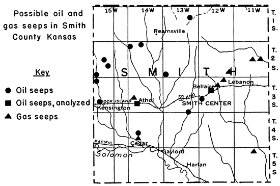
Figure 1 shows the location of reported oil and gas seeps in Smith County which are described here.
Figure 1--Oil and gas seeps in Smith County, Kansas.
The character of the oil itself is the chief deterrent to ascribing a natural origin to the seeps of Smith County. It does not resemble any of the crude petroleum produced in Kansas. On the contrary, the Bellaire oil, at least, is very similar to gasoline in gravity and chemical character, and even its color and odor are suggestive of a refinery product. The Athol oil is dark in color, but otherwise more closely resembles a distillation product than it does a crude oil. The Germantown oil, as previously noted, was utilized as a kerosene substitute.
Only two analyses, both incomplete, of seep oil have been available to us. One of these was furnished by M. R. Dimond, of Smith Center, in letters stating that the analyst was Prof. J. T. Willard, of Kansas State College, Manhattan. This sample, which was collected at Athol, was run in 1917. The analysis follows:
| (1) 4cc | 145-175 |
| (2) 3cc | 175-185 |
| (3) 8cc | 185-195 |
| (4) 12cc | 195-205 |
| (5) 10cc | 205-215 |
| (6) 8cc | 215-225 |
| (7) 8cc | 225-235 |
| (8) 4cc | 235-245 |
| (9) 5cc | 245-255 |
| (10) 6cc | 255-265 |
| (11) 4cc | 265-275 |
| (12) 5cc | 275-285 |
| (13) 5cc | 285-295 |
| Baume | 42.2 |
| Westphal | 0.813 |
| Boiling | 145-300 |
All distillates were colorless. Carbonaceous residue containing coloring matter was left. Another sample, from Bellaire, was brought to Lawrence by Geary Wyland, and was analyzed by John Moore, petroleum engineer, State Geological Survey of Kansas, in the laboratories of the Department of Petroleum Engineering at the University. Mr. Moore divided the sample in two parts and ran each part separately. His report follows:
| Temperatures | ||
|---|---|---|
| No. 1 | No. 2 | |
| Initial drop | 160 | 162 |
| 10cc | 237 | 240 |
| 20cc | 262 | 266 |
| 30cc | 278 | 278 |
| 40cc | 295 | 291 |
| 50cc | 307 | 306 |
| 60cc | 322 | 322 |
| 70cc | 339 | 338 |
| 80cc | 359 | 358 |
| 90cc | 384 | 382 |
| Final No. cc (End Point) |
414 | 412 |
| Recovery | 97cc | 97cc |
| Residue | 1.5 | 1.5 |
| Loss | 1.5 | 1.5 |
| Gravity | 56.1 | |
Mr. Moore's comments on his analyses follow:
"The sample sent to the laboratory last June by Mr. Wyland of the State Tax Commission was distilled according to the A. S. T. M. Distillation Method for gasoline, and closely resembled a U. S. motor grade gasoline, or the gasoline fraction obtained from a cracking still operating on fuel oil. Its color and odor closely resembled the latter, although they may be due to contact with other organic material in the sand."
Dr. H. C. Allen, of the Department of Chemistry, University of Kansas, reports that he has made partial analyses of a number of Smith County seep samples at a number of times in the past, and that the tests made have shown a wide range in the hydrocarbons present, which has convinced him of the natural origin of the oil and gas (H. C. Allen, informal communication).
Local evidence does not support the logical conclusion that the oil has escaped from storage tanks. The unusual character of the oil possibly can be explained as a result of filtration during migration.
The surface geology of Smith County is very simple. The youngest rock, except for alluvium in the beds of streams, is the Ogallala formation, of Tertiary age. This rock covers the surface as a veneer in the northwest corner of the county and also occurs in a narrow outlier extending southeastward from the southern part of T. 1 S., R. 13 W., to a point a mile or two west of Bellaire. No seeps of oil or gas have been reported from either of these two areas of Tertiary rock.
The rest of the county, except for relatively small areas in the southern and southeastern parts, is floored with the chalky shale and chalk of the Niobrara formation of Cretaceous age. This formation is thinnest in the southeastern part of the county, where the underlying Carlile shale (Cretaceous) is exposed, and is thickest beneath the cap of Tertiary rocks in the southwestern corner. All but one of the seeps shown in figure 1 occur in the area floored by the Niobrara formation. Most of these seeps occur, however, where the chalky shale has been broken down through weathering activities into a veneer of soil several feet thick.
Only the upper part of the Carlile shale is exposed in Smith County. This rock consists of a blue, compact and noncalcareous shale, with a thin and lensing sandy layer, the Codell sandstone, at the top. The gas seep in section 3, T. 5 S., R. 11 W., in the southeast part of the county, is the only seep known to us in the area of outcrop of the Carlile shale.
The Niobrara formation consists in the upper part of a series of thin chalk beds alternating with thicker chalky shale beds, and in the lowermost 60 or 70 feet, of thick beds of compact chalk. The Niobrara rocks are, however, notably brittle, and are cut by numerous faults of small displacement. These faults are especially prominent to the west in parts of Phillips county, where the Niobrara formation is better exposed (Landes, Kenneth K., Geology and Mineral Resources of Phillips county, Kansas. Report in preparation.). The Niobrara formation is not known to carry any oil in the Great Plains region.
The Carlile shale consists of about 300 feet of beds, the uppermost 200 feet of which is a very dense blue clay shale and the rest a somewhat calcareous clay shale. The Carlile formation, also, has not been found to be oil-bearing in the Great Plains province.
Below the Carlile are the Greenhorn and Graneros formations (Cretaceous). The former consists of chalky shale and thin but persistent limestone beds. The Greenhorn has a total thickness of about 80 feet. The underlying Graneros is a clay shale with a thickness of 20 to 30 feet in this part of the state. These formations have not been productive of oil or gas in either western Kansas or eastern Colorado.
The next oldest formation, the Dakota, also of Cretaceous age, has produced some oil in eastern Colorado, especially along the Rocky Mountain Front, but of the hundreds of wells that have been drilled through it in western Kansas, none have so much as reported an encouraging show of oil or gas. The Dakota consists of thick beds of clay and sandy shale, and large, somewhat erratic lenses of sandstone. The sandy layers are invariably filled with water.
The underlying Permian formations consist of red shale in the upper part and, in some areas of the state, thick beds of gypsum and salt. The lower part consists of alternating beds of shale and limestone, The great gas field in southwestern Kansas produces from porous zones in Lower Permian limestone.
The depth to the top of the next older series of rocks, the Pennsylvanian, is more than 2,000 feet in parts of Smith County. The Pennsylvanian rocks are similar to those of the Lower Permian in that they consist of alternating shale and limestone beds. The latter, however, are much thicker in some of the Pennsylvanian formations. Many of the oil and gas reservoirs in central and western Kansas lie in Pennsylvanian rocks. The Topeka limestone, which is a prolific producing formation in the Bemis pool of Ellis county, the Lansing-Kansas City beds, which produce large quantities of oil in many of the Russell county pools, and the Wherry formation ("basal Pennsylvanian conglomerate") are examples of producing rocks of Pennsylvanian age in Kansas.
It is in the Pennsylvanian that the first good opportunity lies for the possible source of the oil and gas seeping to the surface in Smith County. Below the Pennsylvanian are the following rocks, which are productive of oil and gas in other parts of the state: "Mississippi lime," Hunton, Viola, Simpson ("Wilcox sand"), and Arbuckle ("siliceous lime").
It seems to us unlikely that the source of the oil and gas seeping to the surface in Smith County is to be found in the shallow formations. These formations are notably devoid of oil in other parts of the state where they have been adequately tested, and with exception of the sandstone layers in the Dakota, they lack rocks with sufficient porosity to store any appreciable amount of gas or liquid. Under the circumstances, the best guess that can be made is that the source of the oil is in formations of Pennsylvanian age which occur in Smith County at depths in excess of 2,000 feet. If the oil and gas came from this depth, they had to pass through a thick series of sedimentary formations, some of which consist of thick clay shales, which are ordinarily considered effective barriers to the migration of oil and gas on any great scale. However, no rock is absolutely pervious to the movement of liquid or gas, and it may be that the lighter, more volatile constituents of the deeply buried crude oil were able to work their way through even the clay beds. These would have a natural selective filtration effect upon the hydrocarbons, and this is a possible explanation for the light gravity and the other qualities of the seep oil that gave it the appearance of a refinery product rather than a naturally occurring petroleum. Migration through the more brittle rocks, such as the limestones, might have been expedited by the presence of joints and other types of fissures.
Kansas Geological Survey, Oil and Gas Seeps in Smith County, Kansas
Placed on web July 9, 2015; originally published in May 1, 1939.
Comments to webadmin@kgs.ku.edu
The URL for this page is http://www.kgs.ku.edu/Publications/Bulletins/MRC12/index.html