Kansas Geological Survey, OGI 9
Originally published in 1953 as Kansas Geological Survey Oil and Gas Investigations 9. This is, in general, the original text as published. The information has not been updated. An Acrobat PDF version (38.7 MB) is also available.
Cross section 9, extending from Meade County northeastward to Smith County, Kansas, was prepared as a cooperative project between the U.S. Geological Survey and the State Geological Survey of Kansas. The cross sections already published show the stratigraphic relations of the pre-Cretaceous formations in western Kansas and eastern Colorado. Cross section 9 shows the stratigraphic relations of the formations above the Arbuckle sequence on a line crossing the Central Kansas uplift from the Salina basin to the Hugoton embayment of the Anadarko basin. An analysis of the structural development of the Central Kansas uplift by means of a series of skeleton cross sections reveals the several conflicting structural movements that from time to time warped the originally flat beds into their present position.
The 11 wells used in the cross section were drilled by rotary tools and complete or nearly complete sets of samples and electric logs were available except for the upper part in some of the wells. These wells are spaced at intervals of 15 to 40 miles in as straight a line as possible in order to avoid the introduction into the cross section of illusory structural features inherent in a cross section that zigzags across an inclined surface.
Logs of these wells were first plotted from the examination of rotary samples and then adjusted to the electric logs in an effort to eliminate the lag in the recovery of the cuttings. For the wells in which electric log data are missing for the Cretaceous and Upper Permian rocks the sample logs have been used without correction inasmuch as the lag in the upper 500 to 1,000 feet does not ordinarily impair the essential accuracy of the sample determinations.
For some wells in which neither samples nor electric logs were available in the upper part, interpretation of the driller's log was attempted where it seemed to supply pertinent data, as in well 7, where the Dakota formation seems to be indicated by "redbeds" to a depth of 220 feet. In some other wells, data from near-by wells have been utilized to fill in details not available, as in well 5, which is a composite of two wells. A well in sec. 9, T. 16 S., R. 18 W., has an electric log for depths below 1,071 feet. This log was checked against the sample log of a well about 3 miles away in sec. 2. After these data were adjusted for elevation they supplied the details above 1,071 feet. Water wells reported in ground-water bulletins of the State Geological Survey of Kansas supplied data not otherwise available on the local thickness of the Dakota formation. The sequence of samples above 1,080 feet in well 10 is broken and some reliance is placed on the driller's log for the top of the Permian.
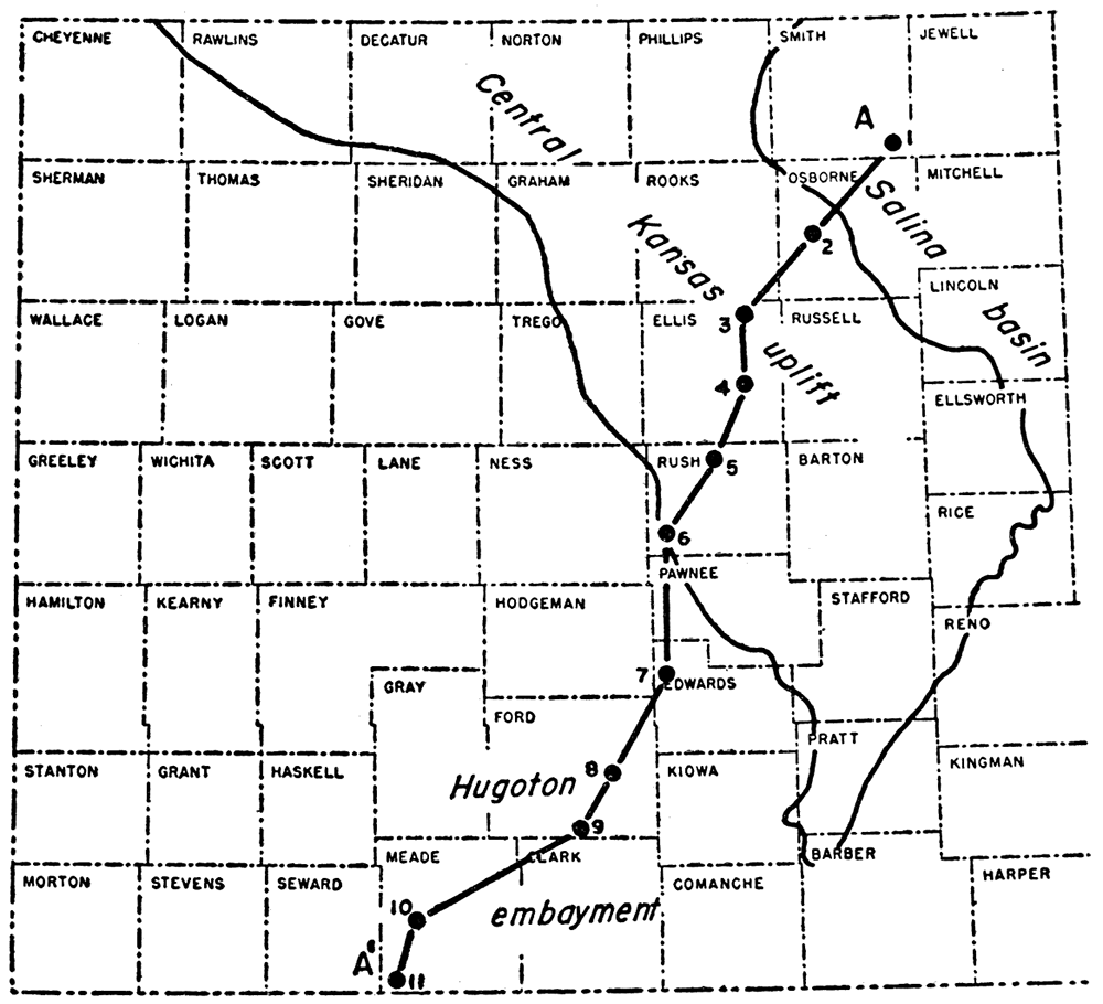
Figure 1—Map of central and western Kansas showing principal structural features in relation to cross section A-A'. The Central Kansas uplift outlined by pre-Pennsylvanian margin of Mississippian limestones (southwestern margin after Claire, 1948); slight movement before Mississippian time, major activity from end of Mississippian time through early Permian time. Salina basin shown by synclinal axis; active from end of Mississippian time through early Permian. Hugoton embayment, initiated in preMississippian time, active from end of Mississippian time to Kansas City time, revived in late Permian time.
[Note: The stratigraphic nomenclature used in this report is that of the State Geological Survey of Kansas and does not conform to the nomenclature of the United States Geological Survey.]
The samples from most of the wells used in the cross section do not include material for the study of the Quaternary and Tertiary rocks. Their thickness and distribution in the counties on the line of the cross section are discussed in the several reports on geology and ground-water resources of Meade (Frye, 1942, pp. 94-112), Ford (Waite, 1942, p. 154-170), Edwards and Pawnee (McLaughlin, 1949, p. 82-90), and Russell (Frye and Brazil, 1943, p. 28-30) counties. Information being assembled for a bulletin on Jewell County (Fishel and Leonard, 1956) supplies generalized data pertinent to well 1 in an area adjacent to the southeastern corner of Smith County.
The Quaternary deposits in some of the well logs of the cross section are reported vaguely as "surface" or "surface rocks," but not many samples have been saved. The Quaternary deposits on the line of the cross section, as described by Frye and Leonard (1952) are more than 200 feet thick in some places and consist of recent alluvium and terrace deposits along present or recently eroded valleys and of upland deposits of Pleistocene shale, clay, silty and sandy shale, and impure sandstone. These upland deposits once formed a more or less continuous sheet, which is now interrupted by present-day valleys. The Pleistocene deposits are unconformable on Tertiary rocks, on Cretaceous rocks, and on Permian rocks.
Tertiary rocks were recognized in the samples only in wells 9, 10, and 11 in a basin in Tertiary rocks in Meade County, but they probably occur also as a relatively thin surface deposit in wells 7 and 8. The samples of the Ogallala formation, which forms the greater part of the, Tertiary, consist mainly of coarse sand and. gravel, the constituent grains of which are of extremely varied lithologic character. Clays and shales have for the most part been lost in drilling and are commonly not represented in the samples. More than 300 feet of Ogallala rocks seems to be present in well 10. The thickness of the Ogallala reported by Frye (1942, well 18, p. 143) in sec. 20, T. 33 S., R. 29 W., is 403 feet. The Ogallala seems to be absent on the line of the cross section from wells 7 to 1, where Quaternary deposits seemingly rest on the Cretaceous. Well 11 encountered 405 feet of post-Permian rocks. The upper 180 feet consists of sand and gravel definitely of Ogallala age. At least a part and possibly all the remaining 225 feet consists of or includes the mouse-gray and tan marl or calcareous shale and sand of the Laverne formation (Frye, 1942, pp. 94-97). Samples of the bottom 15 feet consist of gravel. The thickness is greater than the maximum that has been reported for the Laverne formation of the Tertiary, but no material suggesting the presence of Permian rocks was observed in this sequence of samples.
Colorado group
No Cretaceous rocks younger than the Colorado group are encountered in the subsurface on the line of the cross section. The Colorado group comprises in descending order the Niobrara chalk, the Carlile shale, the Greenhorn limestone, and the Graneros shale.
The Carlile shale is the youngest of these formations represented in the cross section. It is divided into, three members—the Codell sandstone member at the top, the Blue Hill shale member in the middle, and the Fairport chalky shale member at the bottom. The Codell sandstone member, about 22 feet thick in Ellis County (Bass, 1926, p. 28), becomes thinner toward the northeast. It was not sampled in any of the wells used in the cross section but may be present above the first samples in wells 1 and 2. The Blue Hill shale member consists of gray-black to dark-gray noncalcareous shale. Samples from well 1 indicate a thickness of at least 150 feet. The member is probably present also in the unsampled upper parts of wells 2 and 4. The Fairport chalky shale member consists of dark blue-gray to very dark-gray chalky shale, finely laminated with chalk and grained with fine chalky pellets of foraminiferal origin. Many samples contain fragments of shells and brown fish scales, and samples from the lower part contain locally a few Globigerina. The Fairport is 110 feet thick in well 1. In well 2 only the lower 45 feet is represented in the samples. In well 3 the Fairport is cut out by valley alluvium, but in well 4 it is probably present in the upper 200 feet, for which there are no samples. The Fairport closely resembles the underlying Greenhorn limestone, from which it is distinguished by faunal criteria in outcrops and by a bed of firm chalky limestone at the top of the Greenhorn (Swineford and Williams, 1945, p. 114). In the absence of adequate fossils, the contact of the Fairport and the Greenhorn is placed arbitrarily at the top of the first firm chalky limestone.
In well 1 the contact of the Fairport chalky shale member of the Carlile shale and the Greenhorn limestone is marked by a change to slightly lighter gray as well as by firm chalky limestone. There is also a marked increase in the number of shell fragments and Globigerina. Fragments of fish scales are also present. The Greenhorn ranges in thickness from 75 to 108 feet; it has an average thickness of 89 feet in wells 1 to 4. It extends downward to the noncalcareous Graneros shale. Inasmuch as the Graneros shale tends to disintegrate in drilling, the point of contact as determined from samples is vague in some wells.
The noncalcareous shale of the Graneros is generally black to very dark gray. In many localities it is interstratified with beds of fine impure glauconitic sandstone and siltstone. Some pyrite is present. It is 55 feet thick in well 1 and thins to less than 20 feet in well 4, although there are probably many irregularities in thickness between the two wells. The Graneros is probably present in wells 5 and 6. The contact of the Graneros with the underlying Dakota formation is indicated by the appearance of ferric iron, clay, and lignite.
The lowest formation of the Gulfian Series is the Dakota formation. About one-fourth of the formation consists of sandstone, which is erratically distributed vertically and horizontally in channel deposits and other lenticular bodies. About three-fourths of the formation (Plummer and Romary, 1947, p. 41) consists of clays of various types, shale, and some lignite and charcoal. Siderite, pyrite in minor amounts, limonite, and other iron minerals that are mostly oxidized are abundant throughout the formation. Most of the samples contain conspicuous amounts of siderite either as fragments of interbedded sheets and coarse nodules or as small pellets and some samples, owing to loss of soft silt and clay, consist entirely of siderite pellets. Samples from the top of the Dakota in well 3 contain 10 to 15 percent lignite and charcoal.
Although calcareous and glauconitic material has been observed, the formation in the main was deposited under continental and littoral conditions in contrast to the underlying marine Kiowa shale.
The thickness of the Dakota is variable. Its actual thickness, as revealed by its contact with the overlying Graneros shale, ranges from 210 feet in well 1 to 145 feet in well 4. Its thickness as indicated by samples in wells where the Graneros is not present exceeds 270 feet in well 5 and 365 feet in well 6. The lower part of the Dakota is probably present in wells 7 and 8, but pre-Tertiary erosion removed the formation from wells 9, 10, and 11.
The Dakota overlies the dark marine shale and sandstone of the Kiowa shale.
The upper formation of the Comanchean Series in Kansas is the marine Kiowa shale, which locally includes sandstone. The lower formation, the Cheyenne sandstone, is a nonmarine sandstone which locally includes much shale.
The Kiowa shale is composed characteristically of dark calcareous shale that commonly contains shell fragments and pyrite. Some interbedded sandstone, locally variable in amount, occurs in many localities and because of the loss of shale in drilling, the more resistant sandstone forms a disproportionate part of the recovered cuttings. The sandstone is fine grained, angular, and dirty and generally contains pyrite, glauconite, and shell fragments. The thickness of the Kiowa increases irregularly from 90 feet in well 1 to 195 feet in well 8, except in well 6, where the Kiowa is only 85 feet thick because of its overlap on the Permian.
The contact of the Kiowa shale and the Cheyenne sandstone is placed at the point where pyritiferous dark shale or fine glauconitic and pyritiferous angular sandstone of the Kiowa gives way to coarser grained sand with inclusions of polished subrounded grains.
Although composed characteristically of sandstone, the Cheyenne includes also dark-gray silty shale in some areas. The sand is generally coarser than the sand in the Kiowa shale, and pyrite is absent or rare. The included subrounded and polished sand grains were probably derived from the not far distant pre-Cretaceous outcrops of the Cedar Hills sandstone. In well 7, beds correlated with the Cheyenne consist of dark and pinkish clay shale, the latter possibly derived from adjacent exposed areas of nonsandy shale of Permian age. The Cheyenne sandstone, as pointed out by Swineford and Williams (1945, p. 123), is mainly noncalcareous and nonmicaceous in contrast to the sandstone beds of the Kiowa shale.
The Cheyenne sandstone rests unconformably on a surface of Permian redbeds of considerable local relief, except in the area of well 6 where the Kiowa shale overlapped on beds of Permian age. In wells 10 and 11 the entire Cretaceous sequence was eroded and replaced by Tertiary rocks.
The Permian redbeds were tilted and eroded prior to the deposition of the Cretaceous. A low angular unconformity occurs at the contact, and although the surface had local topographic relief, the Permian rocks were roughly beveled during the erosion intervals, as shown by the fact that the Permian rocks that underlie the Cretaceous are older toward the north and east than toward the south and west (Kellett, 1932; Norton, 1939, figs. 2 and 3).
The Guadalupian Series in Kansas includes all the rocks above the Dog Creek-Blaine sequence. It consists, in downward order, of the Taloga formation of the Quartermaster group, the Day Creek dolomite, and the Whitehorse sandstone. Wells 6, 7, 8, 9, and possibly 10 penetrated Guadalupian rocks, but in well 10 neither samples nor electric log is available for determining the position of the Dog Creek-Blaine sequence. In well 11 the Blaine and younger formations have been cut out by Tertiary rocks. Thickness of the Guadalupian is 140 feet in well 6, 185 feet in well 7, and 135 feet in well 9. Pre-Cretaceous erosion entirely removed Guadalupian rocks in the area of wells 1 to 5.
The Whitehorse sandstone has a thickness of about 270 feet in surface outcrops (Moore and others, 1951, p. 37), but only the lower part is present in wells 6 to 9. Red and gray mottled sandstone, siltstone, and silty shale predominate. Minute double-ended dolomite crystals occur in the basal beds immediately above the Blaine in well 6 and contaminate the samples hundreds of feet lower. Most of the crystals are slightly worn and vaguely resemble fusulinids. In well 7 rare chips of dolomite of uncertain origin occur in the samples up to 160 feet above the Blaine. In view of the spreading interval between the Stone Corral dolomite and the Blaine formation in wells 6 to 9 it seems unlikely that the Whitehorse occurs in well 11 below the Laverne formation (Tertiary).
Nippewalla group
The Nippewalla group, the upper of two groups into which the Leonardian Series of Kansas has been divided in outcrops, extends downward from the top of the Dog Creek shale to the top of the Stone Corral formation. It includes in descending order, the Dog Creek shale and the Blaine formation, consisting together of a sequence of relatively thin dolomite and gypsum or anhydrite beds interbedded with red shale; the Flowerpot shale, which is soft, red, and gypsiferous; the Cedar Hills sandstone; the Salt Plain formation, which consists mainly of red silty shale with interbedded sandstones; and the Harper sandstone, which is mainly red and gray sandstone with interbedded red shale. The thickness of the group ranges from 610 feet in well 6 to 870 feet in well 9. The spreading of the interval on the line of the cross section suggests that in well 10 the group may have been originally more than 1,000 feet thick and in well 11 even thicker.
The Dog Creek shale at the top of the Nippewalla group was not recognized; if it is represented by dolomite or gypsum it has been included in the Blaine formation. In the cuttings, only the undivided Dog Creek shale and Blaine formation and the Cedar Hills sandstone can be distinguished in the long sequence of red silty shale and soft red sandstone that make up most of the Leonardian Series. The Dog Creek-Blaine sequence is clearly recognizable as a unit in the samples from wells 6, 7, 8, and 9, but is only indicated in the electric logs. It is worthy of comment that in wells 6 and 7, nearest the margin of the basin, the cuttings recovered from the sequence are dominantly dolomite but in wells 8 and 9 they consist almost entirely of gypsum or anhydrite. The thickness of the Dog CreekBlaine sequence in the four wells varies little, averaging about 25 feet.
The upper part of the Flowerpot shale seems from the samples to include more sand than in the outcrops, but it is probable that some if not all the sand in the upper part results from recirculation and ravelling from the Whitehorse sandstone. The lower part at least is red shale. In well 11, some 72 feet of gypsum occurs in the lower part of the Flowerpot shale, at depths of 690 to 742 feet below the surface. This deposit was at first correlated with the Blaine, but the southwestward expansion of rocks of the Nippewalla group from well 6 to well 9 makes this correlation unlikely. A thin bed of gypsum occurs a short interval above the Cedar Hills sandstone in wells 8 and 9, and in wells 6 and 7 there is a corresponding thin bed of dolomite with which the thick lentil of gypsum in well 11 is correlated on the cross section.
The Cedar Hills sandstone consists of red sand and siltstone interstratified with silty shale. The sandstones, which are medium to fine-grained, are in the main orange colored and include many polished subrounded grains slightly coarser than the more angular particles in which they are embedded. Because the sandstone crumbles easily, coherent fragments are rare in the cuttings. Although the Cedar Hills, as represented in the samples, includes some beds of firm sandstone, it falls short of being the distinctive lithologic unit of the outcrops. Recognizable sequences of Cedar Hills sandstone are shown on the cross section, but their upper and lower limits in the samples and electric logs are vague and indeterminate and the Cedar Hills is an indefinite lithologic zone in the subsurface. In wells 4 and 11 the cuttings include considerable numbers of rough sandy pellets whose grains in well 11 are joined by calcareous cement and in well 4 by gray siliceous or sideritic cement. In wells 7, 8, and 9 neither cuttings nor electric logs reveal the presence of sandstone at the position of the Cedar Hills, but some sandstone is present in wells 10 and 11 at the proper stratigraphic position.
Samples referred to the Salt Plain formation and the Harper sandstone are not characteristic of the formations at the outcrops. Instead of sandstone, the samples consist almost entirely of silty and micaceous red shales. The absence of sandstone in the cuttings may be attributed in part to the crumbling nature of the sandstones and their loss in circulation. Norton (1939, p. 1786), however, reported that the sandstones of the Harper die out into silty and micaceous shales to the north and west of the outcrops and are indistinguishable from associated red siltstone. The only well in which Harper sandstone was recognizable is well 8, which yielded about 40 feet of sandstone immediately overlying the Stone Corral dolomite. In well 11 the samples from the position of the Harper sandstone, immediately above the Stone Corral, consist of gypsum crystals and interlaminations of gypsum in silty red shale.
Sumner group
The Sumner group, the lower of the two divisions of the Leonardian Series, consists of the Stone Corral dolomite, the Ninnescah shale, and the Wellington formation. The Stone Corral sequence consists at the surface predominantly of slabby dolomite beds due to the leaching of interbedded layers of anhydrite and gypsum and has in consequence become known as the Stone Corral dolomite. In the subsurface it consists of a variable sequence of evaporites and shale with locally interbedded dolomite and was long known as the Cimarron anhydrite. In view of the lack of lithologic continuity, it seems more appropriate to refer to the sequence as the Stone Corral formation or the longer more descriptive term Stone Corral dolomite-anhydrite as proposed by Norton.
In well 1 the cuttings consist of silty limestone and dolomite with anhydrite laminae and traces of white chert. In well 2 the formation seems from the samples to consist of anhydrite with dolomite integrated with anhydrite. In well 5 dolomite predominates. In wells 8 to 11, the samples consist mainly of anhydrite, but in each of these wells 10 to 20 feet of gray earthy and marly dolomite interlaminated with anhydrite underlies the main body of anhydrite.
In wells 1 to 6 the Stone Corral is overlain by silty shale. In well 7 the overlying sediment, which is 110 feet thick, is soft red marly dolomite and dolomitic anhydrite. In well 8 the Stone Corral is overlain by 40 feet of fine red sandstone. In wells 9, 10, and 11 it is overlain by red clay and red silty shale, which in well 11 include crystalline anhydrite. It is possible to interpret these phenomena, especially in wells 7 and 8, as evidence to substantiate Norton's (1939, p. 1782) concept of an unconformity at the top of the Stone CorraL The thickness of the Stone Corral, exclusive of the marly dolomites above and below in some wells, increases irregularly from 30 feet in well! to more than 70 feet in well 11.
The Ninnescah shale underlying the Stone Corral dolomite is the lowest Permian formation that consists predominantly of redbeds. Samples from the upper part consist mainly of red clay shale in part slightly silty. The lower part consists of mottled and laminated gray-green, red, and maroon clay shales in which there seem to be some thin beds of red siltstone and fine sandstone.
The fine-textured Runnymede sandstone member traced in outcrops at and near the top of the Ninnescah shale was noted in wells 4, 6, 8, and 9 from 5 to 25 feet below the base of the Stone Corral dolomite and may be present in other wells although not recognized in the samples. The contact of the Ninnescah with the underlying gray and very dark-gray shale of the Wellington formation is obscured in the samples by recirculated gray Cretaceous shales and bleached shale from the basal Ninnescah. Although the lower limit of the Ninnescah is vague, the formation increases in thickness toward the southwest from 120 feet in well 4 to about 360 feet in well 11.
The Wellington formation in this part of Kansas is conveniently divided into three members. The upper member, as yet unnamed, extends from the base of the Ninnescah to the top of the second member, the Hutchinson salt. The third member extends from the base of the salt to the top of the Nolans limestone, the uppermost member of the Chase group.
The upper member includes the "upper gray beds," the "redbeds," and the "middle gray beds" of Ver Wiebe's (1937, pp. 15-17) classification of the Wellington formation in the subsurface. These units are only vaguely revealed by the study of rotary well samples. The upper member of the Wellington formation contains considerable amounts of gypsum and in most of the wells the change in the color of the shales from red to gray is accompanied by the appearance of gypsum and gypsiferous shales whose thickness and abundance increase southwestward on the line of the cross section in proportion to the increase in the thickness of the entire member. Gypsum is particularly abundant at the base of the member and the contact with the underlying salt member is transitional. In wells 2 and 7 and possibly in other wells a few salt molds occur in the gypsum above the upper surface of the salt.
The Hutchinson salt member consists of crystalline salt interstratified with thick and thin beds and laminae of gypsum or anhydrite and, in part, of intermixtures of salt and gypsum. The limits of the salt member have been determined mainly from electric logs. In the absence of an electric log, the upper limit of the salt beds can be determined with approximate accuracy by the appearance in the sample of salt molds pitting the anhydrite laminae remaining after the solution of the salt in the drilling mud and also by the increased proportion in the sample of recirculated material from the slush pit for the salt beds contribute little or nothing to the recovered samples. The base of the salt, which grades downward into dolomite, is more difficult to determine accurately. The salt member is missing in well 1, probably by nondeposition. It increases in thickness from well 2 toward the southwest with considerable regularity, reaching a maximum of 490 feet in well 9; it then thins to about 350 feet in well 11.
The third member of the Wellington formation consists of gray shale interstratified with anhydrite of irregular thickness, purity, and distribution. It includes near the base the Hollenberg limestone bed which is characterized in most wells as far southwest as well 11 by a unique earthy gray dolomite enclosing disseminated granules of dark anhydrite. The Hollenberg bed is an impure limestone that is about 25 feet above the Nolans in well 7 and about 80 feet above it in well 9. The Hollenberg is probably less than 5 feet thick in most wells toward the northeast, but it increases to 10 feet toward the southwest.
The Wolfcampian Series in Kansas is divided into the Chase, Council Grove, and Admire groups. The Chase and Council Grove groups and also several of the groups of the Pennsylvanian System consist of formations that are dominantly limestone separated by formations that are dominantly shale. Most of the formations called limestones include shale members and many of the the formations that are dominantly shale include limestones or calcareous beds. The limestone formations, because of their greater hardness, are more conspicuous and more easily recognized in samples and consequently are stratigraphically more important that the more obscure shale formations.
Chase group
The limestone formations of the Chase group at the top of the Wolfcampian Series are the Nolans at the top, followed below by the Winfield, Barneston, and Wreford limestones. All are conspicuously cherty in the outcrops; but the chert in the samples from wells is variable and either absent or inconspicuous in some areas of the subsurface. The intervening shale formations are commonly red or partly red or variegated. The Towanda is a limestone member of the Doyle shale, which occurs between the Winfield and the Barneston limestones and the Kinney is a limestone member of the Matfield shale which occurs between the Barneston and the Wreford limestones. The over-all thickness of the Chase group ranges from 320 feet in well 1 in the Salina basin to 470 feet in well 11 in the Hugoton embayment. In well 4, on the crest of the Central Kansas uplift, the Chase thins to 295 feet.
The Nolans limestone, which has an average thickness of about 23 feet, consists mainly of sucrose dolomite, dolomitic marl, and impure dolomite except in wells 1, 2, and 3, where it is an impure earthy limestone interbedded with shale, and in well 5, where it is in part an algal silty and siliceous limestone. Some chert occurs in the Nolans in about half the wells.
The Winfield, like the Nolans, is a limestone in wells 1, 2, and 5, but is a dolomite in all the other wells. The samples are not conspicuously cherty, but in the wells toward the northeast the Winfield is silty and siliceous. Toward the southwest it becomes argillaceous. The three members into which this formation is divided in the outcrops are commonly not recognized, but the electric logs of some wells reveal a middle shale member. The thickness, which is irregular, averages 23 feet.
The Towanda limestone member of the Doyle shale is commonly an impure dolomite or dolomitic shale of varying thickness. Toward the southwest it becomes a sucrose dolomite with pin-point porosity. In well 5, in which both the Nolans and the Winfield are limestone, the Towanda also is a marly and impure limestone. The Towanda is partly limestone and partly dolomite in wells 3 and 4, and cherty in wells 4, 6, and 8. It is 10 to 15 feet thick in wells 6 and 7, but in the other wells its thickness ranges from 20 to 50 feet, increasing irregularly toward the southwest to a maximum in well 11.
The Barneston limestone consists of two limestone members separated by the Oketo shale member. The upper limestone member, the Fort Riley, is the youngest unit of persistent limestone, although in well 1 part of the limestone is dolomitic. In wells 3 and 6 the Fort Riley is oolitic; Traces of fusulinids were noted in the cuttings from wells 3 and 5. The thickness of the Fort Riley ranges from 30 feet in the northeast to more than 50 feet in the southwest in Meade County. The Oketo shale member consists mainly of chalky shale, but in wells 7 and 8 it is a porous sucrose dolomite 10 to 30 feet thick. The Florence, the basal limestone member of the Barneston, varies in character, ranging from very dark and medium-gray silty and argillaceous limestone to gray fossiliferous semigranular limestone. It is conspicuously cherty in all the wells, especially in the lower part, and some samples include as much as 20 percent chert. The Florence member has a thickness of 20 to 35 feet in wells 2 to 4, increasing to 75 feet in wells 10 and 11.
The over-all thickness of the Barneston limestone increases more or less regularly from 45 feet in well 5 to 150 feet in well 10. The increase is the result of thickening of both the limestones and the intervening Oketo shale member.
The Kinney limestone member of-the Matfield shale is gray, fossiliferous, and granular toward the northeast, becoming darker, denser, and impure toward the southwest. It seems to be noncherty. Its average thickness is less than 10 feet.
The Wreford limestone toward the northeast is gray, granular, silty, siliceous, and cherty; toward the southwest it becomes darker and argillaceous. The samples from this formation are ordinarily characterized by conspicuous amounts of chert, but no chert was noted in the samples of this formation from wells 6 and 9 and only traces from wells 7 and 11. The electric logs reveal that the limestone sequence of this formation in some of the wells is broken by shale beds. The thickness of the Wreford ranges from 12 to 40 feet.
Council Grove group
The Council Grove group includes the following predominantly limestone formations in descending order: Funston, Crouse, Bader, Beattie, Grenola, Red Eagle, and Foraker limestones. The intervening shales, with the exception of the Blue Rapids shale between the Funston and the Crouse and the Johnson shale between the Red Eagle and the Foraker, are in part or entirely red or variegated shales in the outcrops. The shales that are interbedded in the predominantly limestone formations are black or gray shales or gray calcareous shales. The thickness of the Council Grove group (base of Wreford to base of Foraker) is 315 feet in well 1, in the Salina basin, 240 feet in well 4, on the crest of the Central Kansas uplift, and 365 feet in well 11, in the Hugoton basin.
The Funston limestone, rarely more than 10 feet thick, is variable in character but approximately constant in thickness and in its relation to adjacent formations. In the northeast it is generally sublithographic and dense but becomes granular or earthy or mealy toward the southwest. In wells 9 and 10, the Funston increases in thickness to 15 or 20 feet by the incorporation of a local overlying lenticular algal and pseudo-oolitic limestone.
The Crouse limestone, which is 5 to 10 feet thick, is gray, argillaceous to dense, and finely granular, not differing materially from the other limestone formations except in well 10, where it is composed in part of chalky oolitic limestone and oolitic chert . It has been erroneously reported in the driller's log of this well as the Neva limestone member of the older Grenola limestone. In well 9 the Crouse is algal but not oolitic.
The Bader and Beattie limestones in outcrops are each about 20 feet thick and are separated by the Stearns shale, the upper part of which is calcareous and, in southern Kansas, fossiliferous. The Beattie includes at its base the well-known Cottonwood limestone member. In the subsurface the Bader and Beattie are ordinarily each about 15 feet thick. The Stearns shale, which separates them, is 40 feet thick in the Salina basin (well 1) and 10 to 20 feet thick on the Central Kansas uplift (wells 4 and 5). Southwest of the Central Kansas uplift the Stearns shale thickens (wells 8 to 11) and includes one to three limestone beds, the number and thickness increasing toward the southwest. The Cottonwood limestone member of the Beattie in wells 1 to 5 displays an abundance of the fusulinids that are characteristic of the outcrops, but farther southwest fusulinids are not conspicuous in the samples.
The over-all thickness of the undifferentiated Bader-Beattie sequence is 60 feet in the Salina basin (well 1); only 35 feet on the Central Kansas uplift (well 5); and 105 feet in the Hugoton basin (well 11).
The Eskridge shale, although only one of several red shale formations, is generally recognized by its brilliant color and its position below the Cottonwood and above the Neva limestone member at the top of the Grenola limestone. Its thickness is irregular, but ranges from 20 to 40 feet. In wells 10 and 11 the shale includes a thin limestone bed and the red color is less conspicuous.
The Grenola limestone consists of two well-defined limestone members separated by shale; these form a characteristic pattern in most of the electric logs. Except in wells 1, 10, and 11 the Neva limestone member at the top of the Grenola is conspicuously oolitic. Aside from this feature the texture of the limestones of the Grenola ranges from mealy to semigranular. The thickness of the Grenola limestone ranges from 40 to 50 feet.
The Red Eagle limestone is not prominent in either the samples or the electric logs, but it seems to be present in all the wells, ranging from 5 to 15 feet in thickness except in well 11, where it seems to be 30 feet thick.
The Foraker limestone is the basal formation of the Council Grove group. In the outcrops it consists of two thin beds of limestone separated by a 40-foot sequence of black shale beds and calcareous gray fossiliferous shale; these grade into limestone toward the south. Both the limestone and the shale contain fusulinids in abundance. In the subsurface also fusulinids are abundant but the caving of the shale enriches the cuttings below the Foraker with fusulinids and obscures the position of the base of the Foraker in the sample logs. Although for this reason the base of the Foraker in some wells is a little vague, the Foraker limestone is about 60 feet thick in well 1, about 40 feet in well 5, about 90 feet in well 9, and 65 feet in well 11.
Admire group
The Admire group consists of an erratic sequence of thin impure limestones, red and gray shales, silty and sandy shales, and sandstone. The group is disconformable on the underlying Pennsylvanian rocks, whose surface in some places along the outcrops has been channeled to a depth of 120 feet.
The group includes the thin limestones listed below in descending order: the Houchen Creek limestone member of the Hamlin shale, the Five Point, Falls City, and Aspinwall limestones. The basal formation, the Towle shale, includes locally channel fillings known as the Indian Cave sandstone member. The correlation of the limestones as shown in the cross section is to some extent speculative, as is also the contact of Permian and Pennsylvanian rocks, for the lower beds of the Permian and the upper beds of the Pennsylvanian are similar and in many areas show no striking lithologic distinctions at the contact. The thickness of the Admire group ranges from 190 to 335 feet, depending on the topography of the pre-Permian surface.
The Pennsylvanian System is represented in Kansas by the Virgilian and Missourian Series of Late Pennsylvanian age, the Desmoinesian and Atokan Series of Middle Pennsylvanian age, and the Morrowan Series of Early Pennsylvanian age. The Atokan and Morrowan Series occur in the subsurface in southwestern Kansas but do not crop out.
The Virgilian Series extends from the base of the Admire group to the top of the Pedee group or, in its absence, to the top of the Lansing group of the Missourian Series. It varies inversely in thickness with the thickness of the overlying Admire group on account of the unconformity at its top, but it varies in thickness also because of structural movements that were active contemporaneously with its deposition. The Virgilian Series is about 565 feet thick in the Salina basin, 515 feet thick on the Central Kansas uplift, and 800 feet thick in well 11, in the Hugoton basin. The series is divided into the Wabaunsee group at the top and the Shawnee and Douglas groups below.
Wabaunsee group
The Wabaunsee group is a more or less clastic sequence consisting, in most of the area of the cross section, mainly of shale interstratified with limestone formations, several of which are doubtfully correlated on the cross section. The limestones recognized in the outcrops of the Wabaunsee group consist in descending order of the Brownville, Caneyville, Jim Creek, Grandhaven, Dover, Maple Hill, Tarkio, Elmont, Reading, Wakarusa, Burlingame, Rulo, Happy Hollow, and Howard limestones. Most of these limestones are thin; the thicker formations are rarely more than 15 feet thick and are, broken by shale members that are rarely recognizable in well samples. The younger formations above the Dover limestone seem to be absent in the surface of the northeastern half of the cross section in wells 1 to 7. In wells 8 and 9 more than 100 feet of younger Wabaunsee rocks, which probably include limestones as young as the Brownville, have been logged. In wells 10 and 11 the upper part of the Wabaunsee group consists mainly of limestone with very little shale. The lower part below the Wakarusa limestone in well 11, as revealed by samples and electric logs, consists entirely of shale, although both samples and electric logs show a more or less normal sequence in the same interval in well 10.
Shawnee group
The Shawnee group in the outcrops consists of the following formations, which are composed dominantly of limestone: the Topeka, Deer Creek, Lecompton, and Oread limestones. They are separated by shale formations, one of which, the Kanwaka shale between the Lecompton and the Oread, includes the persistent Clay Creek limestone member. Both the shale formations and the shale members of the limestone formations are thinner in the subsurface than in the outcrops of the formations. Among the persistent features revealed by the cross section is a thin limestone at the top of the Topeka in wells 5 to 8, probably the Coal Creek limestone member, and the thin Ost limestone member of the Tecumseh shale, which is recognizable between the Deer Creek and the Lecompton limestones in all the electric logs from wells 1 to 9. The Heebner shale, Leavenworth limestone, and Snyderville shale members of the Oread are clearly revealed by their distinctive pattern in the electric logs from wells 1 to 7. In wells 8 and 9 the shale members become thicker, altering the expression of the sequence in the electric logs. In well 10 the Leavenworth limestone member is absent and the Oread limestone is represented only by thin limestones at the top and bottom separated by 60 feet of shale. In well 11 the Ore ad consists only of thin sheets of limestone.
The limestones of the Shawnee group tend to grade southward into shale. The Topeka limestone is identifiable as far south as well 10 but is missing in well 11. Only the lower part of the Deer Creek limestone continues to well 11. The Lecompton limestone is absent in wells 10 and 11. The progressive disappearance of the Oread limestone has been mentioned. The Clay Creek limestone member of the Kanwaka shale formation is only a calcareous shale in many of its outcrops, but in the subsurface it is a persistent feature in both samples and electric logs, although its expression in the electric logs seemingly depends upon whether it is locally a calcareous shale or an argillaceous limestone. The thickness of the group, which in well 1 in the Salina basin is 295 feet, increases to 405 feet in well 8 and shows little or no decrease on the crest of the Central Kansas uplift. In well 10, where some of the limestones are missing, the thickness decreases to 390 feet.
Douglas group
The Douglas group consists mainly of clastic rocks; east of the Nemaha anticline it is principally sandstone, but in the subsurface of central and western Kansas where it is thin it is dominantly shale. On the line of the cross section its thickness is 25 feet in well 1, 10 and 15 feet respectively in wells 4 and 5; it increases irregularly to about 100 feet in well 11, where it consists partly of red micaceous siltstone. In wells 2 and 3 the Douglas group includes a thin bed of limestone probably representing the Haskell limestone member of the Stranger formation of the outcrops. In wells 10 and 11 three thin limestones of uncertain correlation occur in the Douglas. Red shale is not uncommon in outcrops of the Douglas group, but the only wells on the cross section in which red shale was recognized are wells 3, 4, 6, and 11. The period of erosion that preceded the deposition of the Douglas and closed the Missourian Epoch removed rocks of the Pedee group from large areas of the outcrops and exposed the upper rocks of the Lansing group. It seems probable that the thin clastic deposits between the Lansing and the Shawnee groups in central Kansas are more apt to be a part of the Douglas group than the Pedee. Where the Pedee group is absent, rocks of the Douglas group rest unconformably on rocks of the Missourian Series.
The Missourian Series extends downward from the unconformity at the base of the Douglas group to the unconformity at the top of the Marmaton group of the Desmoinesian Series. It includes the Pedee group, which is not represented in the cross section, and the Lansing, Kansas City, and Pleasanton groups. The thickness of the series, except locally, is not greatly affected by the erosional relief at its top and bottom except in outcrop areas where a determinable thickness of Pedee rocks survived and where the Pleasanton was deposited locally in channels that were eroded in the upper part of the Marmaton. On the line of the cross section the variations in thickness are due mainly to structural movements that deformed the rocks contemporaneously with their deposition. The thickness is 345 feet in well 1 in the Salina basin, 250 feet in wells 3 and 4 on the Central Kansas uplift, increases southwestward to a maximum of 415 feet in well 8 on the flank of the Hugoton basin, and then thins gradually to 390 feet in well 11.
Lansing and Kansas City groups
At the outcrops the Lansing and Kansas City groups together constitute a sequence of cyclical deposits divided into dominantly limestone formations separated by shale formations. The Lansing group includes the Stanton and Plattsburg limestones; the underlying Kansas City group includes the Wyandotte, Iola, Drum, Westerville, Block, Dennis, Swope, and Hertha limestones. In the subsurface toward the west the shale formations that separate these limestones become thin. As revealed by the electric logs, they are rarely more than 10 feet and generally less than 5 feet thick. The limestone members of these groups are continuous from well 1 to well 11 except that in well 10 the upper members of the Wyandotte were replaced by shale and in wells 4 and 5 the pre-Kansas City surface rose above the level of Hertha deposition. The upper limestone formations of the Lansing and Kansas City groups are irregularly oolitic or oomoldic in wells 1 to 10. In wells 10 and 11 the samples from the Hertha seem to be oolitic.
Pleasanton group
The Pleasanton group in the outcrops is disconformable on the underlying Marmaton group of the Desmoinesian Series and in some areas along the outcrop the upper formations of the Marmaton have been cut out by the clastic deposits of the Pleasanton. On the line of the cross section the Pleasanton is represented by a shale bed from 5 to 20 feet thick and the disconformity is not recognizable. The Pleasanton is missing on the crest of the Central Kansas uplift in wells 4 and 5, probably from nondeposition.
The Desmoinesian Series extends from the base of the Pleasanton to the top of the Mississippian System except in wells 10 and 11 where it extends to the top of the Atokan Series. It consists of two groups, the Marmaton and the Cherokee. The thickness of the Desmoinesian rocks, modified locally by unconformities at the top and bottom, is controlled chiefly by structural movements that preceded Pennsylvanian deposition and continued contemporaneously during Desmoinesian sedimentation. The series is 420 feet thick in well 1, is absent on the crest of the Central Kansas uplift in wells 3, 4, and 5, and increases in the Hugoton basin to 360 feet in well 11, where it overlies rocks of probable Atokan age.
Marmaton group
The Marmaton group at the top of the Desmoinesian Series consists of cyclical deposits of limestone, shale, sandstone, and coal. In the subsurface toward the west the shale beds diminish in thickness and the sandstones disappear. Coal was not recognized in the Marmaton samples of the cross section and individual limestones are only vaguely differentiated except in electric logs. The four Marmaton limestone formations—the Lenapah, Altamont, Pawnee, and Fort Scott limestones—seem to be represented in all the wells except where the Marmaton overlaps on the rising surface of the Central Kansas uplift. Toward the southwest other unnamed limestones, probably in the Cherokee group, make the differentiation of the limestones of the Marmaton group difficult. The group is 125 feet thick in the Salina basin in wells 1 and 2. It is missing from the crest of the Central Kansas uplift in wells 3, 4, and 5, and is only 90 feet thick in well 6, where the lower beds were not deposited. The bottom of the group in well 11, where the Marmaton is probably about 200 feet thick, includes dense brown and black limestones. Because the Cherokee is represented by limestone rather than by shale in wellsB, 10, and 11, the exact contact between the Marmaton and the Cherokee is uncertain.
Cherokee group
The Cherokee shale in the outcrops is a cyclical sequence of sandstone, shale, clay, and coal with only one persistent limestone formation, the Ardmore limestone. In the subsurface the series consists mainly of shale with almost no sandy constituents, but in well 9 limestone is prominent in the upper part and in wells 10 and 11 the Cherokee includes more limestone than shale. A bed of conglomerate generally occurs at the base of the Cherokee but where the underlying rocks are noncherty, as in wells 9, 10, and 11, no basal conglomerate occurs.
In well 1 in the Salina basin, the Cherokee is 295 feet thick, including the basal conglomerate. It consists largely of black shale and red, brown, and yellow variegated shale. The Ardmore limestone occurs 115 feet below the top. In well 2 the Cherokee shale is only 50 feet thick, and in wells 3, 4, 5, 6, and 7 on the crest of the Central Kansas uplift it is absent. In these wells the basal conglomerate of the Pennsylvanian System is younger than the Cherokee. The Cherokee is 100 feet thick in well 8 and increases in thickness regularly to well 11, where it is 430 feet thick. The Cherokee samples in wells 5, 9, 10, and 11 consist largely of dark, black, and brown partly siliceous limestone with minor amounts of interbedded black shale and traces of coal. In wells 10 and 11 the Cherokee overlies siliceous limestone and shale of Atokan age. The contact is obscure and there are differences of opinion as to its correct position. In the sample log of well 10 the contact is placed at a depth of 5,455 feet where sandy and silty shale en,closing clastic fragments of shells immediately overlies a sequence of shale and gray siliceous limestone of probable Atokan age. Some silty limestones occur 60 feet higher, but there is no break in the sequence of cherty black limestones and sandy and silty shale until a depth of 5,455 feet is reached. In well 11 the base of the Cherokee in the sample log is placed at a depth of 5,310 feet, where the sandy dolomitic limestone immediately overlies 50 feet of gray semigranular cherty limestone.
The Atokan Series does not crop out in Kansas, but rocks of Atokan age have been identified by fusulinids in the subsurface in western Oklahoma and traced into the Hugoton embayment by Maher (1948). Rocks believed to be of Atokan age occur only in wells 10 and 11 below the clastic sediments already mentioned. The presence of Atokan rocks in well 11 is confirmed by the recovery from a sample, collected between depths of 5,645 and 5,650 feet, of a silicified fusulinid identified by Cecil Lalicker of the Geology Department of the University of Kansas as Fusulinella. The lower limit of the Atokan Series in this well is placed at a depth of 5,720 feet (sample log), at the top of a sequence of buff, brown, and black limestone believed on lithologic grounds to be of Morrowan age. In well 10, the base of the Atokan is placed at a depth of 5,640 feet (sample log), at the top of calcareous sandstone that somewhat resembles the basal Morrowan rocks in well 11.
Atokan rocks as here separated include gray limestone as well as black and brown limestone and black and dark-gray shale. The upper and lower contacts are placed somewhat arbitrarily at the base of clastic zones such as might mark such disconformities as occur between the Cherokee and Atokan rocks and between Atokan and Morrowan rocks.
The Morrowan Series is logged only in wells 10 and 11. The upper rocks classified as Morrowan in well 11 are brown and black limestones not differing conspicuously from limestones in the Atokan except that they are conspicuously characterized by light-green glauconite that fills cavities in bryozoans, crinoid stems, and other interstitial openings. The limestones are interstratified with dark-gray and black shale. The basal beds of the Morrowan in well 11 at depths of 5,780 to 5,860 feet (sample log) consist of glauconitic sandy limestone and calcareous sandstone. In well 10 the 45 feet of calcareous sandstone penetrated between depths of 5,640 and 5,685 feet (sample log) has been logged as basal Morrowan. This sandstone is not glauconitic as in well 10 and it is possible that the sequence penetrated is actually basal Atokan.
The thickness of the Morrowan Series in well 11 is 135 feet and, as shown somewhat tentatively, in well 10 is 45 feet.
The Mississippian System in the middle west has been divided into the Chesteran, Meramecian, Osagian, and Kinderhookian Series. Except for shale beds of Chesteran age in southwestern Kansas, the silty shale facies of the Sedalia in the Kinderhookian of southeastern Kansas, and green and red calcareous shale and argillaceous limestone in the Fern Glen of south-central Kansas, the Mississippian consists entirely of cherty and noncherty dolomite, limestone, and dolomitic limestone formations,
The present thickness of the Mississippian rocks is mainly dependent on the post-Mississippian structural deformation. After the Pennsylvanian rocks were gently folded, the region was subjected to base-leveling erosion, which removed much or all the Mississippian from anticlinal areas. A part of the thinning of the lower Mississippian rocks, however, is due to wedging out on the flanks of pre-Mississippian topographically high areas and nondeposition on the crests.
On the line of the cross section, Mississippian rocks are 65 feet thick in well 1, but absent on account of pre-Pennsylvanian erosion in wells 2 to 6. They are 625 feet thick in well 8, about 1,620 feet thick in well 10, and 1,530 feet thick in well 11.
Chesteran rocks are present on the line of the cross section only in wells 10 and 11. Maxim K. Elias (personal letter, 1949), who examined fossils from cores taken from well 11, reported that the Elvira, Homberg, and New Design (upper, middle, and lower) groups of the Chesteran rocks of Illinois are represented. In southwestern Kansas, Chesteran rocks consist of a sequence of granular, semigranular, sublithographic, and silty limestones, calcareous shale, and marl formations interstratified with fossiliferous dark-gray and black shale, very dark-gray shale, and toward the base variegated shale, yellow shale, maroon shale, and silty calcareous shale. Fragments of Archimedes, Pentramites, and Bryozoa are not uncommon constituents of the samples. The sample log shows that the basal beds of the sequence in well 11 at depths between 6,130 and 6,160 feet consist largely of buff, maroon, and variegated red and green shale. Although this classification is in disagreement with some interpretations of samples from this well, this shale on lithologic grounds seems more appropriately included in the Chesteran Series than in the underlying Meramecian Ste. Genevieve limestone. The thickness of Chesteran rocks in well 11 is 305 feet, and in well 10 is 280 feet. The Chester an seems to be missing in well 9. A disconformity separates the Chesteran Series from the underlying Meramecian Series.
The Meramecian Series has been divided into the Ste. Genevieve, St. Louis, Spergen, and Warsaw limestones and the Cowley formation.
The Ste. Genevieve limestone consists of silty and sandy limestone. Some beds are oolitic. The oolites are mainly fine-grained, but some medium and coarse-grained oolites occur in silty limestone especially in the lower part of the formation. The Ste. Genevieve is 215 feet thick in well 11 and 200 feet thick in well 10. It is probably conformable on the underlying St. Louis limestone.
The St. Louis limestone differs from the Ste. Genevieve by the absence of silty limestones. It includes, especially in the upper part, considerable amounts of coarse and fine sorted and unsorted oolites. The finely oolitic nature of some of the upper limestone beds is obscured in the dense matrix. The formation includes much semigranular limestone and some chalky limestone. The most characteristic lithologic feature is the lithographic and sublithographic limestone in the lower part, which in some beds is a matrix for fossiliferous granules. Traces of gray, white, and black. chert occur erratically in all parts of the formation. The St. Louis is 160 feet thick in well 10 and 165 feet thick in well 11. The contact of the St. Louis and the Spergen limestone, with which it seems to be conformable, is placed at the first appearance of sucrose dolomite or dolomitic limestone.
The Spergen limestone consists dominantly of granular and semigranular limestone interstratified with beds of sucrose dolomite and dolomitic limestone, which distinguish it from the St. Louis. Chert similar to the underlying Warsaw limestone occurs in some beds, but the proportion of chert in the samples for the Spergen is distinctly less than in those from the Warsaw. Free individuals of Endothyra, not found free in samples from the Warsaw, occur sparsely in cuttings from Spergen granular limestone. Some samples exhibit what seems to be algal crusts. No oolites have been observed in cuttings. The Spergen is the youngest Mississippian formation in well 9, where granular, silty, microfossiliferous limestone and silty algal limestone predominate. There are only traces of chert in this well and no dolomite, but Endothyra occurs in the granular limestones. The thickness of the Spergen in well 11 is 90 feet, in well 10 it is 110 feet, and in well 9, it is 100 feet. The Spergen limestone is conformable on the Warsaw.
The Warsaw limestone is similar to the Spergen in that it is composed of limestone interbedded with dolomite in sucrose beds or beds in which fossil fragments are embedded in a dolomite matrix. The Warsaw is considerably more cherty than the Spergen limestone, and the chert for the most part is characterized by crowded masses of broken microfossils and spicules.
The contacts of the Warsaw limestone with the overlying Spergen limestone and the underlying Cowley formation are transitional and in some localities vague and uncertain. The Warsaw is present in wells 8 to 11. In wells 10 and 11 the Warsaw conformably overlies the Cowley formation. In well 11 the Warsaw is 300 feet thick. The basal 50 feet includes conspicuous glauconitic granular limestone containing the microfossiliferous chert so characteristic of the Warsaw and the Cowley. In well 10, in which the Warsaw is 355 feet thick, 50 feet of the glauconitic limestone occurs at the base of the Warsaw above the silty beds of the Cowley. In well 9 the thickness of the Warsaw is 390 feet. In this well the glauconitic zone seems from the samples to be 150 feet thick, but the correlation of the electric log suggests the probability that the glauconitic material in the lower 100 feet is recirculated material from the upper 50 feet which is regarded as Warsaw. In well 8 the Warsaw is 280 feet thick and is overlain by rocks of Pennsylvanian age. The glauconitic zone is 50 feet thick.
The glauconitic zone is placed in the Warsaw because the limestones and dolomites in which the glauconite occurs are neither silty nor siliceous like the Cowley; the glauconite is light green in color, and of earthy texture, and occurs filling voids in the limestones and dolomites especially in the molds of bryozoans and other fossils and in the center of crinoid joints. The glauconite at the base of the Cowley in southeastern Kansas consists of dark-green clastic grains in silty and siliceous dolomite.
The Cowley formation was preceded by a period of erosion that produced a basin along the southern border of Kansas more than 400 feet deep in some places. The basin was confined toward the north by an upland area whose surface was not deeply eroded. The Cowley formation filled the basin with dolomitic silty and siliceous sediments that leveled off the inequalities of the topography. The conformable Warsaw limestone overlapped upon the only slightly dissected upland area to the north. The Cowley formation is characterized by discontinuity of sedimentation. Its most distinctive rocks consist of silty and siliceous dolomites and limestones and dolomitic siltstones. In some areas large quantities of medium and dark-gray opaque microfossiliferous chert are present. Other types of rock, including beds of granular limestone, are also present. The variations in the sedimentary sequence have led some geologists to conclude that the Cowley is a facies variant of the Keokuk, Burlington, and Fern Glen limestones and the Chattanooga shale in spite of the disconformities at the base of the Keokuk and Fern Glen.
In southeastern Kansas the formation is glauconitic and its basal beds constitute a striking glauconitic zone. The formation has been traced from the type locality in Cowley County westward to Meade County, where the formation consists of silty dolomite or dolomitic siltstone that is less cherty than in southeastern Kansas. Westward the glauconitic constituents at the base decrease and disappear. The thickness of the Cowley in well 11 is 235 feet and in well 10 it is 35 feet. In well 9, the Cowley may be represented in the 100 feet of dolomitic beds between the glauconitic zone of the Warsaw and the top of the Burlington where the samples are badly contaminated. In well 8, a 55- foot stratum of silty and argillaceous dolomite that underlies the glauconitic zone of the Warsaw is believed to represent the overlapping partially clastic deposits of the Cowley.
The Osagian Series in central Kansas includes the Keokuk, Burlington, and Fern Glen limestones. In southeastern Kansas and adjacent states the Fern Glen limestone consists of the Reeds Spring and St. Joe limestones. On the cross section the thickness of the Osagian Series is at a maximum of 485 feet in well 10. The series has been removed by post-Mississippian erosion in wells 2 to 6 but it is partially represented in well 1.
The Keokuk limestone at outcrops in southwestern Missouri (Moore, 1928; Moore, Fowler, and Lyden, 1939; Lauden, 1939) is disconformable on the Burlington or on the Reeds Spring, but the disconformity and differentiation of the two formations are uncertain at some places in the subsurface. Although opaque, semiopaque, gray, spicular, and other types of chert occur in both the Keokuk and Burlington, the lower beds of what have been tentatively called Keokuk are characterized by white "cotton rock" (chert resembling tripoli) and highly siliceous but not cherty white limestones.
In well 1, in the Salina basin, 15 feet of dolomite and tripolitic chert, the only representative of the Osagian Series in this well, overlies the Kinderhookian Gilmore City limestone. In well 8 the 65- foot interval from depths of 5,395 to 5,460 feet has been logged as Keokuk because the basal 30 feet of this sequence includes "tripolitic" chert. Approximately 90 feet of similar limestone with chert of distinctive Keokuk type was observed in samples from well 10 (samples from depths of 6,820 to 6,910 feet) but not in any of the other wells.
The Burlington limestone is characterized by gray and white opaque chert, although other types of chert occur in it. Quartz is common and a more or less characteristic constituent. The Burlington was not observed in well 1 but is present at other points in the subsurface of the Salina basin and is perhaps the most widely distributed of the Mississippian formations of Kansas. The Burlington occurs on the southwestern flank of the Central Kansas uplift as well as in eastern Kansas, but it was removed from the crest of the Central Kansas uplift by post-Mississippian erosion.
The Burlington limestone (perhaps in some wells including some Keokuk limestone) ranges in thickness from 70 feet in well 11 where the upper beds have been cut out by the Cowley formation to 150 feet in well 10; it then thins to 120 feet in well 9 and 60 feet in well 8. The Burlington seems to be conformable with the underlying Fern Glen; the contact is transitional and not everywhere clear.
The Fern Glen limestones wedge out toward the north in central Kansas and are absent in well 1 in the Salina basin and in other parts of northeastern Kansas. If the upper beds of the Fern Glen ever reached the area of the Central Kansas uplift in central Kansas, they were removed from that area by post-Mississippian erosion.
In south-central Kansas the Fern Glen consists mainly of semigranular limestone which is in part red. The chert, which occurs only in minor amounts, is semitranslucent, generally pale blue or gray, and has a chalcedonic luster and a conchoidal or splintery fracture. The basal beds in that area become dark grey and argillaceous as they near the flank of the Central Kansas uplift.
In southwestern Kansas the Fern Glen consists mainly of semigranular limestone in part interstratified with sucrose dolomite or semigranular limestone with interstitial dolomite. Lithographic and sublithographic limestones are common especially in the upper part. The chert is semitranslucent and chalcedonic and in addition to the pale-blue shades characteristic of the Fern Glen in south-central Kansas includes also brown, dark-gray, and black semitranslucent chert reminiscent of the chert in the Reeds Spring dolomite of the type locality. The basal beds (10 to 20 feet thick) in southwestern Kansas are noncherty, dark gray, impure, and argillaceous, and may be correlatives of the St. Joe limestone of southeastern Kansas. In well 11 the Fern Glen includes brown, red, and pink semigranular limestones like samples from wells in south-central Kansas. In well 8, the basal 40 feet consists of sandy and silty limestone, sandstone, and calcareous sandstone. The basal sandstone bed includes grains of weathered chert. These sandstones are commonly referred to as the "Misener sandstone." The "Misener sandstone" however, is the basal member of the Chattanooga shale. The Chattanooga shale was subjected to erosion prior to the deposition of the Kinderhookian limestones, and another period of erosion occurred between the deposition of the Kinderhookian limestones and the Fern Glen. In the absence of the Chattanooga shale in the area it seems to me that the sandstones and sandy limestones at the base of of the Osagian sequence are more likely to represent a basic clastic zone of early Osagian age than a survival of "Misener sandstone."
Part of the sequence herein classified as Fern Glen has been considered by some geologists to be of Chouteau age. The cherts in the Mississippian sequence below the Burlington In wells 8, 9, 10, and 11 seem to be identical with semi translucent chalcedonic cherts of the Fern Glen in south-central Kansas, to which the Fern Glen has been traced step by step from outcrops and wells in southwestern Missouri and southeastern Kansas. The cherts from this interval in wells 8, 9, 10, and 11 include dark semitranslucent chalcedonic cherts reminiscent of the Reeds Spring as well as the blue-gray cherts of the same type characteristic of the Fern Glen in south-central Kansas.
On the other hand, the unique gray stippled smooth and rough chert and the ash-gray microbotryoidal chert typical of the Sedalia-Chouteau sequence of northeastern Kansas is conspicuous by its absence.
Although the contact with the Burlington is not sharp, the Fern Glen is about 150 feet thick in well 11, about 245 feet in well 10, about 175 feet in well 9, and 170 feet including the basal sandy zone in well 8. In well 7 only 35 feet of the Fern Glen survived post-Mississippian beveling. This stratum at the top consists of 20 feet of pink and white noncherty granular limestone and at the base 15 feet of red and gray and dark-green argillaceous limestone characteristic of the Fern Glen in other wells on the flank of the Central Kansas uplift. The Fern Glen is unconformable on the underlying Kinderhookian or older rocks.
The Kinderhookian rocks were deposited in a subsiding basin centered in central Iowa. The formations of this series thin and wedge out toward the southwest both in eastern and in central Kansas (Lee, Leatherock, and Botinelly, 1948, figs. 4 and 6, pp. 130-133). The presence of the Kinderhookian Gilmore City limestone beneath the Fern Glen in wells 1 and 7 and its absence from well 8 and farther southwest conform to the regional pattern of southerly thinning of the Gilmore City and other Kinderhookian formations.
The Gilmore City limestone is well developed in Iowa, where Laudon (1933, p. 17) has reported a thickness of 250 feet. The formation thins southward and is dis conformable with low relief on the Sedalia of northeastern Kansas. It is 45 feet thick in well 1 and 35 feet thick in well 7. In both wells it consists of soft noncherty semigranular limestone, the lower part of which is oolitic. In well 1 it is underlain by a trace of upper buff Sedalia dolomite and 5 feet of Chattanooga shale. In well 7 it overlies the Viola limestone.
The Chattanooga shale is represented only in well 1, where 5 feet of dark shale underlies the Gilmore City. The Chattanooga was probably originally more widespread than now, but much of it was removed by the erosion that preceded the deposition of the Boice shale of northeastern Kansas and southeastern Nebraska.
The Devonian and Silurian rocks commonly referred to collectively as the "Hunton limestone" were penetrated only in well 1. They are separated from each other by an obscure but important unconformity.
The Devonian is unconformable below the Chattanooga shale. During the time represented by this unconformity, structural movements and erosional beveling truncated the Devonian and older rocks. In well 1 the Devonian is represented by 10 feet of the sparsely sandy sucrose dolomite that is characteristic of the basal Devonian in northeastern Kansas. The Devonian is separated from the Silurian by an important unconformity. Before Devonian deposition began the region was gently tilted and rocks from Silurian to Arbuckle were truncated by erosion.
The Silurian rocks of well 1 consist mainly of coarsely sucrose gray dolomite with about 10 feet of pink and yellow and gray crystalline limestone at the top. Below the limestone there is about 20 feet of oolitic dolomite of a kind common at the base of the Silurian. The Silurian is slightly cherty, and oolitic chert occurs at its base in this well. The Silurian section is 35 feet thick in well 1 and is probably essentially conformable with the underlying Sylvan shale.
The Ordovician rocks include the Sylvan shale (Maquoketa shale of Missouri), the Viola limestone (Kimmswick limestone of Missouri), the Simpson formation (of which the St. Peter sandstone is a partial correlative), and the upper formations of the Arbuckle group.
The Sylvan or Maquoketa shale, ordinarily a dolomitic and siliceous shale in northeastern Kansas, is present only in well 1, where it has a normal thickness of 55 feet. The Sylvan seems to be conformable above the Viola limestone.
The Viola limestone is present in all wells of the cross section except wells 3, 4, 5, and 6 on the crest of the Central Kansas uplift, from which it was removed by post-Mississippian or earlier erosion. The Viola is a somewhat variable formation. In some areas it consists almost entirely of dolomite and in others almost entirely of limestone. The cherts are mottled and in part crowded with microfossiliferous organisms, some of which are replaced by quartzose silica. The cherts are generally but not everywhere characterized by black dust-like or coarser black particles, some of which are pyrite, flecking the gray chert. The gray granular limestones are locally mottled with dark-gray splotches. In some areas in northeastern Kansas noncherty limestone or dolomite alternates with persistent cherty beds and can be zoned, but the cherty zones are discontinuous in broader areas.
The noncherty mottled coarsely crystalline limestone bed occurs nearly everywhere at or near the base of the Viola. Between this bed and the shales and sandstones typical of the Simpson formation in Kansas, there is a sandy dolomite, generally brown, 20 to 30 feet thick in northeastern Kansas, that thins southward. This sandy dolomite is regarded by some geologists as a correlative of the Platteville formation of Iowa and the Decorah shale of Missouri and, in consequence, is assumed to be of Simpson age. There is, however, in Kansas, a hiatus between the Viola (Kimmswick of Missouri) limestone and the St. Peter (upper Simpson in Kansas) during which several formations aggregating some 900 feet in thickness were deposited in southeastern Missouri. It seems probable that the sandy dolomite in question represents the basal deposit of the Viola after the hiatus in the same way that the basal Devonian limestone includes disseminated sand grains. On the cross section the sandy bed has been included in the Viola. The presence of sand, however, associates these intermediate beds with the Simpson, and as they are the first sandy beds penetrated in drilling they are commonly assigned to the Simpson, as a matter of convenience.
As the sandy dolomite is relatively thin in Kansas, no great error is involved by its consistent inclusion in the Simpson even if it could be directly demonstrated that the sandy dolomite is of Viola age.
In well 1 the Viola is 280 feet thick. The basal beds consist of nonsandy granular limestone, overlain by limestone that is thickly set with disseminated fine crystals of dolomite. The overlying rocks consist of dense or porous cherty and noncherty dolomite, and the top of the formation is a limestone with disseminated fine phenocrysts of dolomite. In well 2 the formation is 110 feet thick. The basal 10 feet is sandy limestone. The remainder of the formation is almost entirely limestone with minor amounts of gray-flecked chert.
Southwest of the Central Kansas uplift in well 7, the Viola limestone is 85 feet thick. The basal beds consist of soft buff limestone with disseminated dolomite crystals. In the lower 30 feet of the samples between depths of 4,765 and 4,795 feet are traces of poorly sorted white rounded sand in a quartz matrix whose relation to the dolomitic limestone is obscure. The upper beds of the Viola are dolomitic limestone with about 20 feet of porous dolomite at the top. The samples include almost no chert. In well 8 the samples consist entirely of dolomite with considerable amounts of opaque white chert and chert resembling tripoli, neither of which is typical of the Viola. The basal 25 feet is noncherty dolomite, in part sandy. In well 9 the Viola consists of mixed dolomite and limestone with characteristic Viola chert. In wells 10 and 11 the Viola consists entirely of cherty and non cherty limestone. The thickness of the Viola increases toward the southwest from 85 feet in well 7 to 255 feet in well 11.
The Simpson formation consists of a variable sequence of soft porous sandstone, calcareous or silicified sandstone, sandy limestone, light-green, dark-green, and nearly black clay shale, and sandy clay shale. The details of the lithology are not clear from either the rotary cuttings or the electric logs. The soft sandstones are not conspicuous in the cuttings. Many of the cemented sandstones are characterized by thinly disseminated dark-gray to black opaque chitinous grains. Shale constitutes a considerable part of the Simpson sequence in the wells of the cross section except in well 7 from which samples seem to be composed mainly of firmly cemented sandstone. The thickness of the Simpson ranges from 55 to 70 feet except in wells 3 and 6, where the thickness was reduced by postMississippian or earlier erosion, and in wells 4 and 5, from which the formation was removed. An important unconformity separates the Simpson formation from the underlying formations of the Arbuckle group. The perfection of beveling of this surface is expressed by the regularity of the thickness of the Simpson in most of Kansas and the fact that the Simpson overlies different formations of the Arbuckle group at different points. Southward into Oklahoma the Simpson increases greatly in thickness, probably as a result of differential subsidence in that direction during Simpson deposition.
Arbuckle rocks are present in all the wells of the cross section. Few of the wells were drilled more than a few feet into Arbuckle rocks, but well 7 was drilled 277 feet into the Arbuckle. Samples taken from depths between 4,930 and 5,040 feet reveal red and pink coarsely crystalline partly porous dolomite. The lower 30 feet of this sequence is very sandy and together with the overlying pink and red dolomite forms a lithologic unit that may represent the Roubidoux formation. The 46 feet of Arbuckle penetrated in well 6 is similar pink crystalline dolomite but not sandy. In well 7 the dolomite underlying the pink sandy dolomite to the bottom of the hole is composed of coarse crystals of dolomite cemented by soft white chert that leaves a lacelike siliceous residue characteristic of the Eminence dolomite of Missouri. Samples of the Arbuckle from the bottom of well 5 were not available, but the log of the well reported 25 feet of dolomite and 19 feet of Reagan sandstone. A similar sequence underlain by granite has been reported for near-by wells.
The cross section does not show the relation of the Pennsylvanian rocks to the older rocks on the crest of the Central Kansas uplift. As is well known, many wells on the crest of the arch reveal the Pennsylvanian rocks overlying the Pre-Cambrian surface, which in some places, as shown by Walters ( 1946, pp. 660-710), has a relief of 200 feet or more.
Figure 2—Skeletonized cross sections showing development of structure along A-A'. [Also available as a larger Adobe Acrobat PDF file, 5 MB.]
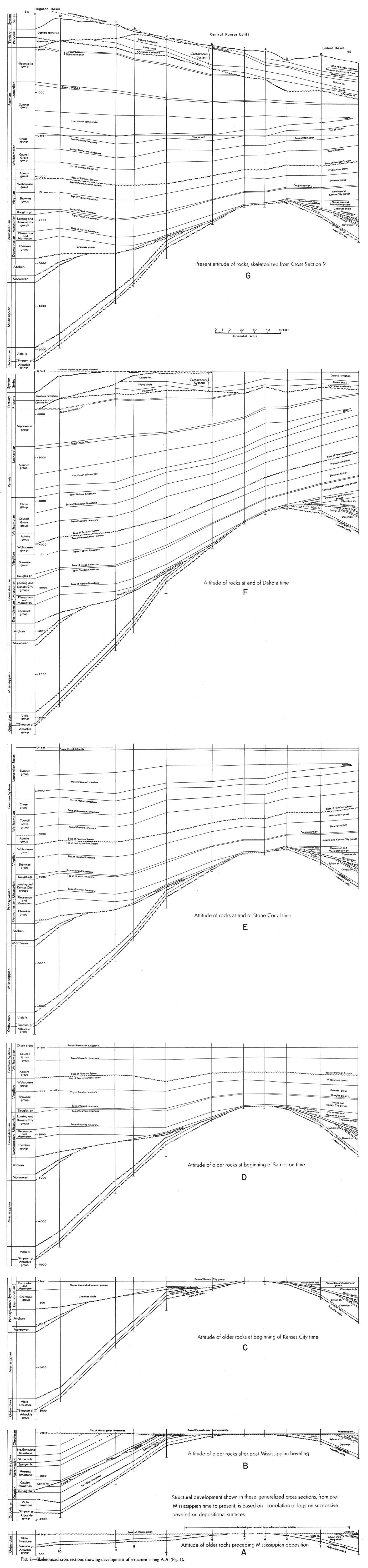
The structural development on the line of the cross section that is transverse to the axis of the Central Kansas uplift is shown by a series of cross sections on Figure 2. The conclusions reached in this report are based on the assumption that at times the surface of the rocks was essentially flat and horizontal and that at times of erosional beveling the topographic relief was negligible in relation to the structural relief indicated.
Figure 2A shows the attitude of the beds prior to Mississippian sedimentation. It is assumed that the pre-Mississippian surface was at one time essentially flat and horizontal. The fact that the Kinderhookian formations thin southward from central Iowa and wedge out in central and southeastern Kansas implies a northward or northeastward tilting of the pre-Mississippian surface during Kinderhookian time. The northward overlap and the thinning of the lower Osagian rocks on the preMississippian and Kinderhookian surface in eastern and central Kansas imply a reversal of structural movement and a southward tilting of the pre-Osagian surface in Osagian time (Lee, Leatherock, and Botinelly, 1948, fig. 4, pp. 66, 131-132). The surface upon which the Osagian and Kinderhookian limestones were deposited in different parts of Kansas was thus not a stable surface at the time Mississippian sedimentation began in different areas.
The upper surface of the Chattanooga shale in eastern Kansas, however, was a demonstrably level surface. The fact that no clastic conglomerate from adjacent areas is found at the present margin of the shale and the evidence of pre-Boice erosion imply that the Chattanooga was originally more widely distributed and that at the end of Chattanooga time there existed a datum plane at its top of much wider extent than now. It is assumed that the perfection of this datum plane was destroyed by erosion of the Chattanooga from areas to the west, but that it remained essentially a flat and level surface even after the early Mississippian movements brought about the Kinderhookian and later the Osagian basins of deposition. Although some error is introduced by the use of this modified post-Chattanooga surface as a datum plane, the error is believed not to modify materially the conclusions of a regional nature that have been drawn from its use as a datum in Figure 2A.
Figure 2A is intended to show essentially the attitude of the pre-Mississippian rocks not in relation to the surface at the beginning of Mississippian sedimentation but the pre-Mississippian surface prior to the early Kinderhookian and early Osagian movements. The Mississippian rocks originally present on the crest of the Central Kansas uplift were removed by post-Mississippian erosion and it is certain that at that time some of the older rocks also were eroded. The restoration of these pre-Mississippian rocks in wells 2 to 7 would thus increase the thickness of the pre-Mississippian rocks in these wells and materially flatten the arch as represented in Figure 2A.
The Sylvan (Maquoketa) shale of Ordovician age and the Silurian and Devonian limestones are present in well 1 in the Salina basin, but they are missing in all the wells southwest of the arch on the margin of the Hugoton embayment. The area of the Hugoton embayment was thus either too high to receive these deposits or, if they were ever present, the Sylvan shale and the Silurian and Devonian rocks were removed before Mississippian time by base-leveling erosion after northeasterly tilting. The date of the initial arching of the Central Kansas uplift is thus uncertain. The arching may not have occurred until after Devonian time.
Figure 2A shows that, although arching of the Central Kansas uplift had begun before the deposition of the Mississippian, the movements were definitely of a minor character as compared with later developments, and that the pre-Mississippian subsidence was greater north of the uplift in the North Kansas basin than to the south in the early Hugoton basin.
Figure 2B shows the attitude of the formations after the post-Mississippian beveling. The logs are correlated on the top of the Pennsylvanian basal conglomerate because this surface is theoretically a smoother surface and more accurately determined than the weathered surface of the Mississippian and older rocks. The guide map, Figure 1, shows the Central Kansas uplift as outlined by the pre-Pennsylvanian margin of the Mississippian limestones. As the line of the cross section is slightly diagonal to the structural axis, the dips shown on the cross section are less than the maximum dips.
Before deposition of Pennsylvanian sediments the beveled post-Mississippian surface subsided more than 1,600 feet at well 10. The thickness of the Mississippian is less in well 11 than in well 10, but Maher and Collins (1949, sheet T) report a thickness of more than 1,700 feet in a well in sec. 9, T. 3 N., R. 21 E., Beaver County, Oklahoma. At the other end of the cross section in well 1 only 65 feet of Mississippian rocks was preserved below the beveled surface in the Salina basin, although in the center of the Salina basin a maximum thickness of 350 feet of Mississippian rocks survived (Lee and Botinelly, 1948, pl. 8). The crest of the Central Kansas arch lies in the area between wells 4 and 5 from which the Mississippian rocks had been removed.
It will be noted, in comparing Figures 2A and 2B, that the major development of the Central Kansas uplift occurred at the end of Mississippian time and that, by comparison, the pre-Mississippian arching was of relatively minor importance.
The Central Kansas uplift has generally been assumed to have been developed contemporaneously with the Chautauqua arch. The Chautauqua arch is flanked on both north and south by rocks of Ordovician (the Viola limestone and the Sylvan shale), Silurian, and Devonian age whose disposition and variations in thickness clearly reveal that the arch began to develop shortly after Simpson time and reached its maximum but not final development before the deposition of the Chattanooga shales (Lee, Grohskopf, Reed, and Hershey, 1946, sheet 2). The map showing thickness of Mississippian rocks of southeastern Kansas shows no appreciable growth of the Chautauqua arch at the end of Mississippian time. Studies of the lower Pennsylvanian rocks show that it was not revived later.
It now seems that the Central Kansas uplift, on the contrary, had only slight development prior to Mississippian time, developed most rapidly at the close of the Mississippian, and continued to rise, but more slowly, during the whole of middle and late Pennsylvanian and early Permian time (Fig. 2).
The Chautauqua arch and the Central Kansas uplift were therefore not entirely contemporary structural features. The Chautauqua arch had no perceptible increment of growth after Chattanooga time, and almost all the arching of the Central Kansas uplift occurred after the Chautauqua arch had become inactive.
Figure 2C shows the relations of the formations at the beginning of Kansas City time. The most striking phenomenon is the continued growth of the Central Kansas uplift. The crest of the arch seems to have shifted toward well 4. Subsidence at well 11 as measured by the thickness of the Desmoinesian, Atokan, and Morrowan Series increased 1,170 feet. In the Salina basin in well 1 the increase during the same time interval was only about 400 feet. At wells 4 and 5, where the crest of the arch remained above the level of Hertha deposition, the Swope limestone was the earliest Kansas City limestone deposited. The Pleasanton and Marmaton seemingly overlapped on the flanks of the arch in much the same way as the earlier Fern Glen limestone did. Well 7 seems to represent a hinge line between the Hugoton embayment and the Central Kansas uplift but possibly local prePennsylvanian arching.
The combined thickness of the Pleasanton and Marmaton groups increases only slightly from wells 8 to 11, revealing that, on the line of the cross section, after Cherokee time the Hugoton embayment was essentially static toward the southwest.
Figure 2D represents the attitude of the formations on the line of the cross section at the beginning of deposition of the Florence limestone member at the base of the Barneston. The base of the Permian is an unconformable horizon of little structural significance and its exact position in some wells is doubtful. Figure 2D reveals very clearly the differential character of the structural movements during the deposition of the sequence from the Kansas City to the Barneston. It reveals continued growth of the Central Kansas uplift from wells 1 to 7, but the increments of folding are much smaller than those shown in Figure 2C. Southwest of well 7 the cross section reveals very little movement in the Hugoton embayment on the line of the cross section.
It must be remembered, however, that the relations shown represent structural movements on the line of the cross section only. Previous work has revealed that during the deposition of the Pennsylvanian sequence the dominant structural feature in the middle west was the Ouachita basin (Lee and Botinelly, 1948, p. 142-146). In Kansas, the Pennsylvanian and early Permian rocks thicken toward the southeast by the gradual increase of the clastic deposits separating the limestones. The magnitude of the Ouachita basin is indicated by the fact that pre-Marmaton rocks of Pennsylvanian age in the Ouachita basin are 18,000 to 20,000 feet thick. During the development of the Ouachita basin, such secondary structural features as the Central Kansas uplift, the Nemaha anticline, and even additional contemporary arching of the Ozark uplift were imposed upon the northern flank of this profound structural trough.
The cross section is essentially at right angles to the direction of subsidence or regional dip into the Ouachita basin. The arching of the Central Kansas uplift was superimposed on the regional dip, but from well 7 to well 11 the line of the cross section follows the strike of the contemporary; structural movements. The structural thickening of the sequence toward the Ouachita basin during this interval was thus at right angles to the line of the cross section or toward the observer. The sequence thins toward the northwest and thickens toward the southeast, and there was probably differential subsidence of the region toward the southeast. There is no indication that the Hugoton embayment was active as a structural feature during this interval except in so far as it remained lower than the Central Kansas uplift, whose crest at the base of the Kansas City at well 4 rose about 500 feet above the base of the Kansas City in well 7 and about 200 feet above the same datum in the Salina basin at well 1.
Figure 2E shows the attitude of the formations on the line of the section at the end of Stone Corral time. There is no expression of increased regional movement of the Central Kansas uplift in beds younger than the Nolans dolomite, after whose deposition the whole region was tilted toward the Hugoton embayment. The basin in which salt beds were deposited is the result of downwarping. The base of the salt is parallel to the Nolans dolomite and the top of the salt northeast of well 7 is parallel to the Stone Corral. Southwest of well 7, previously cited as on a possible hinge line, the interval from the top of the salt to the Stone Corral above becomes regularly thicker toward the southwest. Except for well 4, the salt thickens regularly from well 2 to well 9 and begins to thin from well 9 to well 10 as the cross section approaches the western margin of the salt body. Between wells 9 and 10 the downwarping that formed the salt basin caused all the older beds from the Marmaton to the Nolans to rise toward the southwest.
An anomaly at well 4 may be the result of salt flowage or faulting in the salt zone. The regional tilting has shifted the crest of the Central Kansas uplift at the top of the Arbuckle northeastward to well 3. The regional dip toward the Hugoton embayment raised the base of the Kansas City in well 1 slightly higher than the same horizon in well 3, thus destroying the synclinal character of the Salina basin in formations younger than the Kansas City from this time on. From well 1 to well 11 the dip of the base of the Kansas City was 1,200 feet in 232 miles, an average dip of 5 feet per mile. From well 5 to well 8 the average dip was nearly 12 feet per mile.
Figure 2F shows the attitude of the older rocks at the end of Dakota time. It must be recalled again that the cross section reveals only a component of the deformation. The actual dip during this time may have been more toward the west or south and slightly greater than along the line of the cross section. The top of the Dakota in wells 7 to 11 cannot be determined directly from the wells because erosion has removed the Dakota in whole or in part, or for lack of samples from some wells. In wells 6, 7, and 8 the base of the Dakota has been determined from samples and the elevation of the top determined by adding the thickness revealed by water wells drilled in the vicinity. The original top of the Dakota, which was eroded at wells 9, 10, and 11, has been estimated by extrapolating the top of the Dakota in relation to the Stone Corral in wells 6 and 8, in which the top of the Dakota has been determined with approximate accuracy. Some error is probably introduced by this procedure, but the deformation during this time interval was so great that potential errors of 100 feet or more would not materially modify the relations revealed by the cross section. Figure 2F shows continued subsidence of the Hugoton embayment. The southwestward tilt of the base of the Kansas City between wells 1 and 11 of the cross section amounts to 2,660 feet (nearly 12 feet per mile), an increase of 1,660 feet over the subsidence revealed by Figure 2E. The base of the Kansas City in well 1 lies 330 feet higher than the base of the Kansas City in well 3.
Well 4 again presents an anomaly. The thickening of the salt whether due to salt flowage, faulting, or other phenomena, is probably the expression of local structure and may be discounted regionally. This well, however, serves to suggest the probability that, if more wells had been used, there would have been more irregularities in the cross section at all horizons due to local structural movements.
Since the deposition of the Dakota, the region has been subjected to various structural movements. Deformation during late Cretaceous time and during the Tertiary and Quaternary has raised the Dakota formation in this area high above sea level and in western Kansas has tilted the rocks northward into a deep structural basin in Nebraska. The line of the cross section probably trends slightly east of the direction of the true dip and thus does not reveal the maximum dip of the rocks into the post-Dakota basin.
Figure 2G, a skeletonized form of the large cross section, reveals the present attitude of the formations on the line of the cross section. On the line of the cross section, the dip of the top of the Dakota from well 1 to well 6 is 7 feet per mile toward the northeast. This dip in part cancels out the pre-Dakota dips toward the Hugoton embayment and roughly restores the relations that existed during Stone Corral time in some of the older rocks.
In Stone Corral time, the base of the Kansas City in well 1 was 10 feet higher than the same horizon in well 3. It was 330 feet higher in Dakota time and is now essentially at the same altitude as in Stone Corral time. During Stone Corral time the top of the Arbuckle in well 11 was 4,120 feet lower than its position in well 3 (a gradient of 18 feet per mile on the line of the cross section). At the end of Dakota time the displacement had increased from 4,120 to 5,050 feet (22 feet per mile). The northerly tilt into the basin in Nebraska has now reduced the displacement toward the southwest to 3,680 feet (16 feet per mile).
The top of the Stone Corral is nearly flat northeast of well 7. The top of the salt body is nearly level. The apparent syncline at well 9 is not the Hugoton embayment syncline, which lies farther west, but is instead a result of the warping that formed the salt basin. It is interesting to note that the position of the crest of the Central Kansas uplift at the top of the Arbuckle, as revealed by these few wells, has shifted its position from time to time, but it has never lost its anticlinal character, although other regional features have been altered or eliminated by the vicissitudes of changing structural movements.
It is obvious that any speculation regarding the migration and accumulation of oil must take into account the relatively mild but complex structural movements that have altered the attitude of the rocks at irregular intervals.
The changes of dip must have affected the movements of connate water and nascent oil. Reversals of dip of the order of 20 feet per mile may have produced closures in previously open local anticlines. Under some conditions, previously closed local traps in which oil had already gathered may have been destroyed, with escape and loss of oil and gas.
Some of the local subsurface structural features probably have no expression in the later rocks, and there are probably some structures whose crests near the surface no longer register above their crests in the subsurface.
Bass, N. W. (1926) The geology of Ellis County, Kansas: Kansas Geol. Survey, Bull. 11, pt. 1, pp. 11-52. [available online]
Claire, J. R., 1948, Preliminary notes on lithologic criteria for identification and subdivision of the Mississippian rocks in western Kansas: Kansas Geol. Soc., 14 pp., 2 pls.
Fishel, V.C, and Leonard, A.R., 1956, Geology and ground-water resources of Jewell County, Kansas: Kansas Geological Survey, Bulletin 115, 152 p. [available online]
Frye, J. C., 1942, Geology and ground-water resources of Meade County, Kansas: Kansas Geol. Survey, Bull. 45, 152 p. [available online]
Frye, J. C., and Brazil, J. J., 1943, Ground water in the oil-field areas of Ellis and Russell Counties, Kansas: Kansas Geol. Survey, Bull. 50, 104 p. [available online]
Frye, J. C., and Leonard, A. B., 1952, Pleistocene geology of Kansas: Kansas Geol. Survey, Bull. 99, 230 p. [available online]
Kellett, Betty, 1932, Geologic cross section from western Missouri to western Kansas, Kansas Geol. Soc, Guidebook, 6th Ann. Field Conf.
Laudon, L. R., 1933, The stratigraphy and paleontology of the Gilmore City formation of Iowa: Iowa Univ. Studies in Nat. History, vol. 15, No. 2, pp. 1-74, figs. 1-7, pis. 1-7.
Laudon, L. R., 1939, Stratigraphy of Osage subseries of northeastern Oklahoma: Am. Assoc. Petroleum Geologists Bull., vol. 23, p. 329.
Lee, Wallace, Grohskopf, J. G., Reed, E. C., and Hershey, H. G., 1946, The structural development of the Forest City basin in Missouri, Kansas, Iowa, and Nebraska: U. S. Geol. Survey, Oil and Gas Investi., Prelim. Map 48, 7 maps. [available online]
Lee, Wallace, Leatherock, Constance, and Botinelly, Theodore, 1948, Stratigraphy and structural development of the Salina basin: Kansas Geol. Survey, Bull. 74, 155 p. [available online]
Maher, J. C., 1948, Subsurface geologic cross section from Baca County to Yuma County, Colorado: Kansas Geol. Survey, Oil and Gas Investi., Prelim. Cross Sec. No. 6, pp. 1-11. [available online]
Maher, J. C., and Collins, J. B., 1949, Pre-Pennsylvanian geology of southwestern Kansas, southeastern Colorado, and the Oklahoma panhandle: U. S. Geol. Survey, Oil and Gas Investi., Prelim. Map 101, 4 sheets, scale 1:1,013,760. [available online]
McLaughlin, T. G., 1949, Geology and ground-water resources of Pawnee and Edwards Counties, Kansas: Kansas Geol. Survey, Bull. 80, 189 p. [available online]
Moore, R. C., 1928, Early Mississippian formations in Missouri: Missouri Bur. Geology and Mines, vol. 21, 2d ser.
Moore, R. C., Fowler, G. M., and Lyden, J. P., 1939, Tri-state district of Missouri, Kansas, and Oklahoma; in, Contributions to a knowledge of the lead and zinc deposits of the Mississippi valley region, edited by E. S. Bastin: Geol. Soc. America, Special Paper 24, p. 1-12.
Moore, R. C., and others (1951) The Kansas rock column: Kansas Geol. Survey, Bull. 89, p. 1-132. [available online]
Norton, G. H., 1939, Permian redbeds of Kansas: Am. Assoc. Petroleum Geologists Bull., vol. 23, no. 12, pp. 1751-1819.
Plummer, Norman, and Romary, J. E., 1947, Kansas clay, Dakota Formation: Kansas Geol. Survey, Bull. 67, 241 p.
Swineford, A. and Williams, H.L., 1945, The Cheyenne Sandstone and adjacent formations of a part of Russell County, Kansas: Kansas Geological Survey, Bulletin 60, part 4, pp. 101-168. [available online]
Ver Wiebe, W. A., 1937, The Wellington Formation of central Kansas: Municipal University of Wichita, University Studies, Bull. No. 2, v. 12, no. 5, p. 3-18.
Waite, H. A., 1942, Geology and groundwater resources of Ford County, Kansas: Kansas Geol. Survey, Bull. 43, 250 p. [available online]
Walters, R. F., 1946, Buried Pre-Cambrian hills in northeastern Barton County, central Kansas: Am. Assoc. Petroleum Geologists Bull., vol. 30, no. 5, pp. 660-710.
Kansas Geological Survey
Placed on web Sept. 21, 2018; originally published in 1953.
Comments to webadmin@kgs.ku.edu
The URL for this page is http://www.kgs.ku.edu/Publications/Bulletins/OGI9/index.html