Kansas Geological Survey, OGI 28, originally published in 1963
Next Page--Detailed sample logs
Originally published in 1963 as Kansas Geological Survey Oil and Gas Investigations 28. This is, in general, the original text as published. The information has not been updated. An Acrobat PDF version (12 MB) is also available; plate available separately.
The cross section extends across south-central Kansas from the Zenith-Peace Creek oil field on the southeastern flank of the Central Kansas Uplift in Stafford County eastward across the north-central part of the Sedgwick Basin to the Augusta oil field on the Nemaha Anticline in Butler County. Lithologic composition and general structural attitude of the Paleozoic rocks are shown by sample logs of 19 wells on sea level datum at a vertical scale of 1 inch equals 200 feet and a horizontal scale of 1 inch equals 3 miles. Detailed descriptions of the samples of each well are given in the appendix.
The Paleozoic rocks range in thickness from about 3,000 feet to at least 4,714 feet and represent all systems except the Silurian. Strata of Permian age, as much as 2,440 feet thick, consist mainly of shale in the upper part, anhydrite and salt in the middle part, and limestone, dolomite, and shale in the lower part. Rocks of Pennsylvanian age, 1,319 to 2,061 feet thick, are mostly limestone and shale but include some sandstone. In the eastern part of the cross section the Pennsylvanian rocks are subdivided in part into formations composed mainly of limestone or shale, but many of the stratigraphic contacts become obscure to the west because of a considerable increase in the percentage of limestone. Rocks of Mississippian age, 0 to 408 feet thick, are characterized by limestone and dolomite that is cherty in large part. The Chattanooga Shale of Devonian and Mississippian age is 0 to 226 feet thick and is chiefly shale. Strata of Ordovician age, about 570 to 615 feet thick, are mostly cherty dolomite but include some sandstone, shale, and limestone, mainly in the uppermost part. Rocks of Cambrian age, about 300 feet thick, are chiefly dolomite but include a basal sandstone as much as 60 feet thick. Precambrian rocks, penetrated in two wells, are mostly granite and quartzite.
Major structural features along the cross section include the Augusta Anticline, which is a part of the Nemaha Anticline, the southern end of the Voshell Anticline, arid the southeastern flank of the Central Kansas Uplift. These structures developed mainly after rocks of Mississippian age were deposited and before rocks of Des Moines age (Middle Pennsylvanian) were laid down. Strata of Des Moines age unconformably overlie rocks of Late Mississippian age in the central part of the cross section, the Chattanooga Shale at the western end, and rocks of Middle Ordovician age at the eastern end.
In the area adjacent to the cross section, oil and gas in commercial quantity was first discovered on the Augusta Anticline in 1914, and many other oil and gas fields have subsequently been found in this area. Within 2 miles of the line of the cross section, oil or gas is produced from rocks of Ordovician, Devonian, Mississippian, and Pennsylvanian ages, but the largest production has been from rocks of Ordovician age.
This report is the initial publication of a subsurface study of the stratigraphy, structural development, and occurrence of oil and gas in the Sedgwick Basin in south-central Kansas. Additional cross sections and more comprehensive reports are planned. The work was done under the cooperative agreement between the U.S. Geological Survey and the State Geological Survey of Kansas. All well samples and electrical and radioactivity logs were supplied by the State Survey.
The geologic cross section (Pl. 1) extends from the Stanolind Oil and Gas Co. No. 1 M. Hartnett well in sec. 23, T. 24 S., R.ll W., Stafford County, to the Bennett and Roberts Drilling Co. No. 1 Collins well in sec. 2, T. 28 S., R. 4 E., Butler County, Kansas. The Hartnett well is in the Zenith-Peace Creek oil field located on the southeastern flank of the Central Kansas Uplift, and the Collins well is in the Augusta oil field on the Nemaha Anticline. The location of the cross section in relation to the major structural features in south-central Kansas is shown on the index map on Plate 1. The cross section includes 19 wells numbered from west to east.
The subsurface stratigraphy of the central Kansas oil fields has been well established through years of work by many geologists who have examined samples from thousands of wells and outcrops. Most of the major subdivisions of Cambrian, Ordovician, Silurian, Devonian, and Mississippian rocks that crop out in Oklahoma, Missouri, and Iowa, and many of the rock units of Pennsylvanian and Permian age that crop out in eastern and central Kansas were identified in the subsurface of south-central Kansas by Lee (1949) on a cross section from Barber County to Saline County, Kansas; Lukert (1949) published an electrical-log cross section from Marion County, Kansas, to Garfield County, Oklahoma, that passes within a mile of well 16 of the present report.
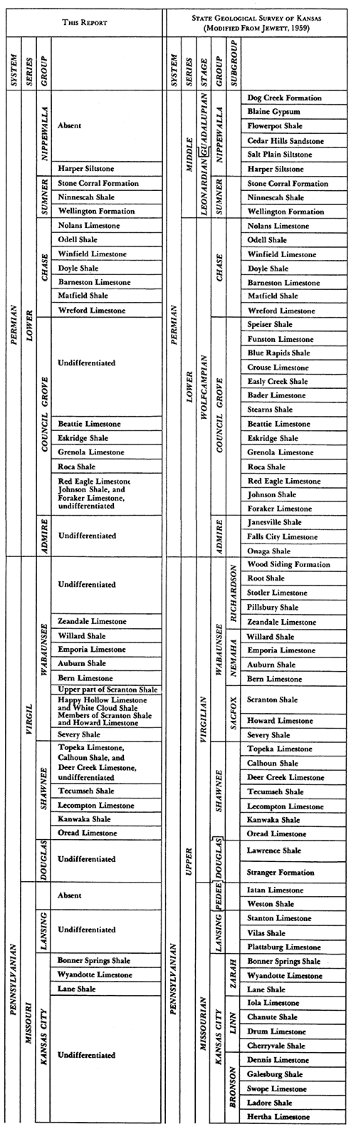
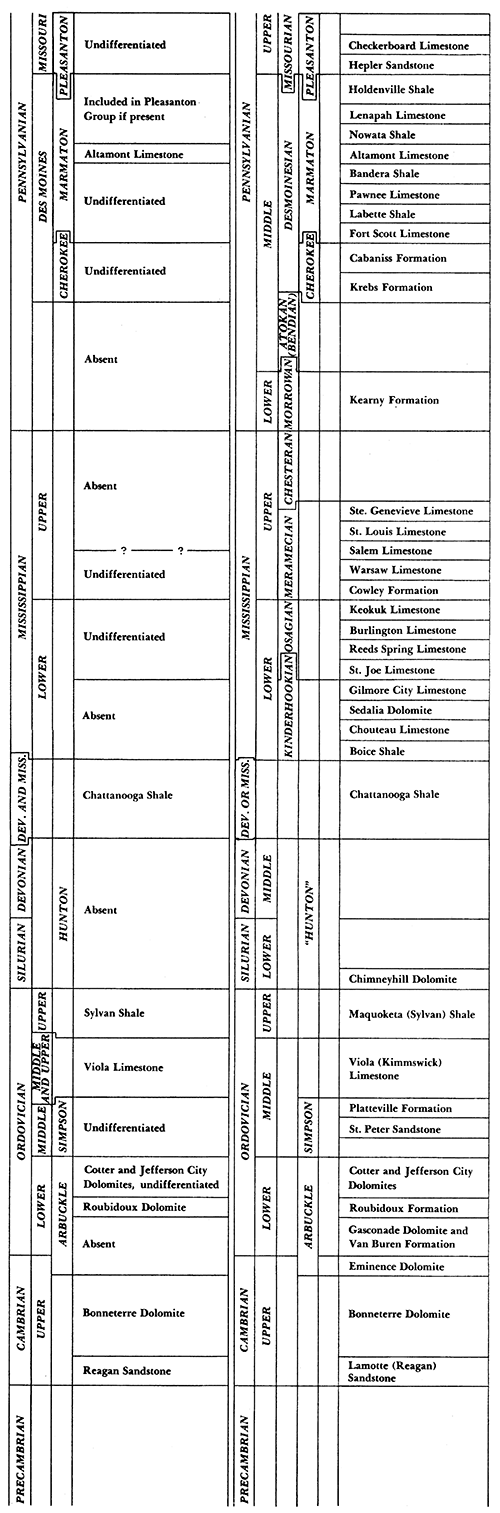
The nomenclature and stratigraphic classification of the U.S. Geological Survey are used in this report except that the Queen Hill Shale Member of Lecompton Limestone is not official nomenclature of the Federal Survey. The nomenclature and classification of the State Geological Survey of Kansas are generally in accord with that of the Federal Survey, but there are some differences, mainly in rank or age. The classification used in this report and the classification of the State Survey are compared in Table 1.
Table 1--Correlation chart showing the stratigraphic units differentiated along the cross section as classified by the U.S. Geological Survey and the classification of the State Geological Survey of Kansas. [An Acrobat PDF version is also available.]
The interpretive method (Maher, 1959) of logging well cuttings was used in this study. Four of the wells in this report (wells 5, 9, 13, and 16) were drilled with cable tools, and with one exception (well 16), the logs of these wells best represent the lithologic sequence studied; some samples from well 16 are not representative of the interval recorded on the sample bags. The other 15 wells were drilled with rotary tools. The logging of eight of these rotary-drilled wells was greatly aided by the concurrent study of electrical or radioactivity logs for these wells. The logging of the other seven was aided by the concurrent study of electrical, radioactivity, or sample logs from nearby wells. Interpretive logs prepared from rotary samples by different geologists are likely to vary somewhat, so that complete agreement regarding details cannot be expected.
Most of the samples were examined under 6.3X magnification, but magnifications of 18X and 27X were used for study of minute features. The color, hardness, mineral composition, texture, and cementing material of the rock fragments were described, and the descriptions include the type and characteristics of accessory particles, such as chert, oolites, microfossils, glauconite, pyrite, calcite, and siderite. The "Rock Color Chart" of the National Research Council (Goddard and others, 1948) was used to determine the rock color, and the Wentworth grade scale was used to describe the mean grain size of the clastic rocks composed chiefly of silicate minerals. This scale was also used as a guide to describe the crystallinity and granularity of the carbonate rocks.
The term shale is used in this report for clastic rocks composed mostly of clay and fine to medium silt-size particles of silicate minerals, regardless of bedding characteristics. The term siltstone designates clastic rocks composed mainly of coarse silt-size particles of silicate minerals. The carbonate rocks were described as silty if an appreciable amount of coarse silt-size or smaller residue remained after treatment with hydrochloric acid. Much of the residue probably is composed of clay-size particles, but this was not determined. The term dense describes carbonates and chert that are composed of particles too small to be seen under 6.3X magnification. The dense rocks commonly break with a smooth conchoidal fracture. Chert is described as spicular if it contains very fine distinct short white lines that probably are fossil spicules. Chert is described as figured if it shows a pattern of fine white to light-gray indistinct and irregular lines in a darker matrix.
The sample logs in this cross section are shown at a vertical scale of 1 inch equals 200 feet. This scale permits the representation of most stratigraphic units, but some of the finer details are not shown. Many of the very thin beds are either exaggerated in thickness or are combined with adjacent beds. The logs are alined on sea level datum, and the horizontal scale is 1 inch equals 3 miles except where noted on the cross section. Well 2 is located so close to well 1 that in the description of the stratigraphy the two wells are treated as one. The electrical or radioactivity logs for eight of the wells, plotted adjacent to the well columns, show the electrical or radioactive character of the geologic formations identified from the samples. The spontaneous-potential curve or the gamma-ray curve is plotted on the left side of the well column, and the short normal resistivity curve or the neutron curve is plotted on the right side. The resistivity curve for well 11 is a laterolog. The type of curve is indicated at the top of each log.
In the vicinity of the. wells of this report the outcropping rocks are Quaternary and Early Permian in age (Latta, 1950, pl. 1; Bayne, 1956, pl. 1; Williams and Lohman, 1949, pl. 1; and Moore and Landes, 1937). Nearly all the wells west of well 14 were started in deposits of Quaternary age, but the base of these deposits could not be determined, because samples were missing for the upper part of these wells. About 58 feet of loose, fine to very coarse feldspathic sand of Quaternary age was penetrated in well 14 above Permian rocks. Permian strata are exposed east of well 14. These rocks are underlain by Pennsylvanian, Mississippian, Devonian, Ordovician, and Cambrian sedimentary rocks and Precambrian igneous and metamorphic rocks. The sequence of sedimentary rocks is 4,714 feet thick in well 2 on the southeastern flank of the Central Kansas Uplift, 4,370 feet thick in well 13 about 24 miles west of the Nemaha Anticline, and about 3,000 feet thick in the vicinity of well 19 on the Nemaha Anticline. The following descriptions of the Paleozoic and Precambrian rocks are generalized from the detailed sample logs, which are included in the appendix.
The rocks of Permian age of this report are part of the Lower Permian Series of the u.s. Geological Survey and are, in descending order, the Nippewalla, Sumner, Chase, Council Grove, and Admire Groups. In a study of the outcropping rocks in Elk County, Verville (1958, p. 13- 17) described the Permian formations below the upper part of the Barneston Limestone of the Chase Group. Many of these formations were extended westward from Elk County to well 19 by correlation of electrical logs for several intervening wells. The approximate thickness of these rocks ranges from 605 feet in well 19 to 2,440 feet in well 1, in which the drillers log was used to determine the top of the Permian rocks. A major unconformity is at the top of the Permian rocks. The lowermost Permian rocks are very similar to the uppermost Pennsylvanian rocks; therefore the contact between the two is difficult to determine.
Nippewalla Group
Rocks of the Nippewalla Group were penetrated in wells 1 to 5 and possibly in well 6, but samples were available only for the lower 150 feet of the group in well 3. The position of the base of the group was interpreted from the drillers log of well 1. The lower part of the Nippewalla Group in well 3 consists chiefly of moderate-reddish-brown siltstone and shale. These rocks are assigned to the Harper Siltstone, which was formerly called the Harper Sandstone.
Sumner Group
The Sumner Group in central Kansas includes, in descending order, the Stone Corral Formation, the Ninnescah Shale, and the Wellington Formation. The group has an average thickness of about 1,120 feet in the western part of the cross section.
The Stone Corral Formation, previously called the Stone Corral Dolomite, consists of light-gray fine-grained silty dolomite about 3 feet thick in well 3. Samples were missing in the other wells, but the drillers log for well 1 includes an 18-foot "sand" at a depth of 510 feet, which is believed to be the Stone Corral. The "sand" probably is mainly anhydrite or gypsum, which is common in the formation in this area.
The Ninnescah Shale is 220 to 260 feet thick in the western part of the cross section where it is composed mainly of moderate-reddish-brown, greenish-gray, and medium-gray shale. The formation also includes beds of light-gray siltstone, white gypsum and anhydrite, and light-gray very finely crystalline dolomite. The amount of gypsum and anhydrite logged in the wells probably is exaggerated. The base of the Ninnescah is difficult to determine, but in this report it is placed at the bottom of the predominantly reddish-brown shale sequence.
The Wellington Formation is present in wells 1 to 17, but to the east of well 9 part of it has been removed by post-Permian erosion. The maximum thickness is 882 feet in well 1. The upper 250 to 300 feet of the Wellington consists mainly of gray, greenish-gray, and moderate-reddish-brown shale and white gypsum and anhydrite, but includes some light-gray dolomite and siltstone. The middle part of the Wellington, which is slightly more than 400 feet thick in well 3, includes much salt and lesser amounts of light-gray anhydrite and gray shale. The lower 150 to 210 feet of the formation is mainly light-gray anhydrite and gray shale but includes one or more beds of light-olive-gray to medium-gray silty dolomite. The salt in the lower part in well 10 and the silty limestone and dolomite shown in the upper 85 feet of well 16 probably are not representative of the strata drilled.
Chase Group
The Chase Group is 340 to 395 feet thick and includes, in descending order, the Nolans Limestone, Odell Shale, Winfield Limestone, Doyle Shale, Barneston Limestone, Matfield Shale, and Wreford Limestone. Because of incomplete samples and because of lithologic changes, the formations above the Barneston were not differentiated west of well 6. The Chase is composed mainly of limestone and dolomite, which is commonly very fine to fine grained or very finely to finely crystalline.
The Nolans Limestone, 20 to 58 feet thick, is mainly medium-gray silty dolomite and gray shale that is dolomitic in part. Some of the dolomite contains white to dark-gray chert.
The Odell Shale is 11 to 28 feet thick and consists chiefly of medium-light-gray silty dolomite and gray dolomitic or limy shale. Some medium-gray limestone is present in wells 9 and 10, and in a few wells the Odell contains small amounts of light-gray dolomitic siltstone, greenish-gray and grayish-red shale, and light-gray anhydrite. In well 7 the upper half of the Odell is anhydrite.
The Winfield Limestone, 20 to 60 feet thick, consists of medium-light-gray partly granular limestone and dolomite and some gray shale. Much of the limestone and dolomite is silty or anhydritic, and light-gray to dark-gray dense mottled or figured chert is present in the Winfield in most wells. The most common fossils in the limestone are crinoids, bryozoans, and ostracodes.
The Doyle Shale is 95 feet thick near the eastern end of the cross section (well 16), but is only about 60 to 75 feet thick in the western half of the cross section. Most of the Doyle is light-gray to medium-gray dolomite and limestone that is silty or anhydritic in part. The rest is gray, grayish-red, and greenish-gray limy or dolomitic shale and light-gray anhydrite. Because the carbonates in the Doyle are very similar to those in the adjacent formations, the upper and lower formational boundaries are located only approximately.
The Barneston Limestone, 85 to 110 feet thick, consists mainly of light-gray to pale-yellowish-brown limestone, medium-gray silty limestone, and light-gray dolomite. Part of the limestone is dolomitic in some wells, and finely oolitic and oolicastic limestone is fairly common in the upper part of the formation. The lower 25 to 40 feet of the Barneston includes much light-gray to medium-gray mottled dense to granular spicular fossiliferous chert,. Fossil fragments generally are abundant in the Barneston, especially the lower part. The most common fossils are crinoids, bryozoans, fusulinids, brachiopods, and ostracodes.
The Matfield Shale is 38 to 63 feet thick and is composed of light-gray to medium-gray and pale-yellowish-brown partly silty limestone and gray, grayish-red, and greenish-gray generally limy shale. Limestone makes up a large percentage of the formation, especially in well 1 and wells 6 to 10. The base of the Matfield is difficult to determine in several wells because the basal limestone beds are similar to those at the top of the underlying Wreford Limestone.
The Wreford Limestone, 35 to 60 feet thick, consists chiefly of light-gray to pale-yellowish-brown fossiliferous limestone and some medium-gray limy shale and silty limestone. The limestone contains much light-gray to medium-dark-gray dense to granular spicular fossiliferous chert. Fossils identified in the Wreford include crinoids, fusulinids, brachiopods, bryozoans, and ostracodes.
Council Grove Group
The Council Grove Group is 305 to 386 feet thick along this cross section. These rocks crop out about 25 miles east of the cross section in northwestern Elk County, where they are divided into 14 formations. Several of the formations in the middle and lower parts of the group were traced westward and identified in well 19. These formations, in descending order, the Beattie Limestone, Eskridge Shale, Grenola Limestone, Roca Shale, and the Red Eagle Limestone, Johnson Shale, and Foraker Limestone undivided, are tentatively recognized as far west as well 14. Samples are not available for the Council Grove in wells 11, 12, and 13 and for part of the group in well 14. Only the Eskridge Shale is tentatively identified in wells 1 to 10. The rocks that compose the group are chiefly very fine to fine-grained or very finely to finely crystalline limestone and shale, but include some finely crystalline dolomite.
That part of the Council Grove Group above the Beattie Limestone in wells 14 to 19 averages about 95 feet thick and consists almost entirely of interbedded limestone and shale. The limestone is mainly medium light gray to pale yellowish brown and is silty in part. In a few wells some limestone contains medium-gray dense spicular chert. Most of the shale is gray and limy, but grayish-red shale is at or near the top of the group in most wells on the cross section.
The Beattie Limestone, 33 to 52 feet thick, is composed mainly of light-gray to pale-yellowish-brown fossiliferous limestone that is locally cherty, silty, or finely oolitic or oolicastic. The rest of the Beattie is gray and greenish-gray mostly limy shale. Fossils commonly present in the formation include fusulinids, crinoids, bryozoans, ostracodes, and brachiopods.
The Eskridge Shale is 4 to 20 feet thick and is composed of gray, greenish-gray, and grayish-red shale. The upper part of the Eskridge contains a small amount of medium-gray silty limestone in well 19, but this limestone may be the basal bed of the overlying Beattie Limestone.
The Grenola Limestone, 41 to 50 feet thick, consists mainly of medium-gray to pale-yellowish-brown fossiliferous limestone and some gray limy shale. The most common fossils are fusulinids and crinoids.
The Roca Shale, 13 to 27 feet thick, includes about equal amounts of medium-gray to greenish-gray shale and medium-gray silty limestone. In well 19 the Roca includes pale-yellowish-brown limestone.
In wells 14 to 19 the lower part of the Council Grove Group, consisting of the Red Eagle Limestone, Johnson Shale, and Foraker Limestone, was not subdivided, because of the great similarity of these rocks. The undivided sequence is 84 to 129 feet thick and the rocks are mostly limestone but include some shale. The limestone is light gray to medium gray and pale yellowish brown, silty in part, and contains fusulinids, crinoids, and brachiopods, especially in the lower part. Most of the shale is gray and limy, but some greenish-gray and grayish-red shale is present in well 15.
The Council Grove Group west of well 14 is composed chiefly of limestone but includes minor amounts of shale and dolomite. The limestone is very similar to that in the eastern part of the cross section. The shale in wells 1 to 10 is gray, black, greenish gray, and grayish red. Beds, 3 to 30 feet thick, of pale-yellowish-brown finely crystalline dolomite are present locally. The base of the Council Grove Group is a reasonably distinct horizon except in several wells where limestone in the uppermost part of the underlying Admire Group is similar to that in the lowermost part of the Council Grove.
Admire Group
The Admire Group is 83 to 135 feet thick, but the thicknesses are only approximate because the base of the group, which marks the base of the Permian rocks, is obscure in most wells. The contact between the Admire Group and underlying Pennsylvanian rocks was extended westward from surface exposures in northwestern Elk County to well 19 by comparison of electrical logs of several wells located in the intervening area. The position of this contact is believed to be reasonably accurate in wells 19 to 17, but west of well 17 it is less accurate because of lithologic changes in Lower Permian and Upper Pennsylvanian strata and because of incomplete sample coverage in several of the wells. In a southwest-trending cross section through well 9, Lee (1949) placed the base of the Admire Group about 140 feet lower than the position shown in the present report.
The rocks of the Admire Group are mainly gray shale, medium-gray micaceous siltstone, light-gray very fine grained micaceous sandstone, and medium-gray to pale-yellowish-brown fine-grained limestone. Fusulinids and crinoids are present in some of the limestone and shale. Some grayish-red or greenish-gray shale is present in most wells. Small amounts of glauconite are in several of the limestone beds. Limestone is more common in the upper part of the Admire, and sandstone and siltstone are more common in the middle and lower parts.
The rocks of Pennsylvanian age on the cross section are divided, in downward order, into the Virgil, Missouri, and Des Moines Series. The total thickness ranges from 1,319 feet in well 1 on the southeastern flank of the Central Kansas Uplift to 2,061 feet in well 12, but these thicknesses are only approximate because the upper contact is difficult to recognize, and because samples were missing for the uppermost Pennsylvanian and the Lower Permian rocks in well 12. The lower contact is marked by a major unconformity, and on this cross section rocks of Des Moines age overlie strata as young as Late Mississippian and as old as Middle Ordovician.
The Virgil Series comprises, from youngest to oldest, the Wabaunsee, Shawnee, and Douglas Groups. Many of the formations in these groups were extended westward from outcrops in Elk County, described by Verville (1958, p. 17-27), to well 19 by comparison of electrical logs for wells in the intervening area. The approximate thickness of the Virgil Series ranges from 920 feet in well 1 to 1,185 feet in well 13. The series is characterized by much shale, siltstone, and sandstone in the upper and lower parts and much limestone in the middle part. The limestone is generally very fine to fine grained or very finely to finely crystalline and is similar to limestone in rocks of Permian age.
Wabaunsee Group
The Wabaunsee Group, 450 to 543 feet thick, includes 12 formations in the area of outcrop in eastern Kansas, but several of these formations could not be identified in the wells of this cross section. Along much of the cross section the Wabaunsee Group can be informally divided into three parts: an upper part consisting mainly of shale, siltstone, and sandstone; a middle part mainly of limestone and shale; and a lower part of shale, siltstone, and limestone.
The upper 95 to 165 feet of the Wabaunsee Group consist mainly of gray shale, medium-light-gray micaceous siltstone, and light-gray very fine to fine-grained micaceous sandstone, but includes some medium-gray to pale-yellowish-brown limestone. The limestone beds are generally about 2 to 6 feet thick, and several are silty or dolomitic. Fossils are fairly scarce and include chiefly crinoids and ostracodes. In some wells the upper part of the Wabaunsee also contains some greenish-gray, brownish-gray, and grayish-red shale. A thin bed of coal is present in wells 5 and 15.
The middle part of the Wabaunsee Group, 140 to 185 feet thick, is divided in most wells into, in descending order, the Zeandale Limestone, Willard Shale, Emporia Limestone, Auburn Shale, and Bern Limestone, but the formational contacts generally are obscure because of the lithologic similarity of the formations. These rocks are chiefly interbedded gray shale and medium-light-gray to brownish-gray limestone. Part of the Bern Limestone contains glauconite and some grayish-red silty limestone or oolitic limestone in several wells. Many of the limestone beds are silty, several are dolomitic, and most are locally fossiliferous. Fusulinids and crinoids are fairly common, and other fossils include ostracodes, brachiopods, bryozoans, and pelecypods. The middle part of the Wabaunsee Group also contains some medium-gray micaceous siltstone and medium-light-gray very fine to fine-grained micaceous sandstone.
The lower part of the Wabaunsee Group is 165 to 245 feet thick. It is composed of, in downward order, the Scranton Shale, Howard Limestone, and Severy Shale. The upper part of the Scranton Shale, 40 to 130 feet thick, consists of gray silty shale, micaceous siltstone, and some light-gray very fine grained sandstone and medium-light-gray to brownish-gray limestone. The lower part of the Scranton Shale, consisting of the Happy Hollow Limestone and White Cloud Shale Members, and the Howard Limestone form a dominantly limestone sequence 53 to 92 feet thick. The limestone is chiefly medium light gray to pale yellowish brown and silty, oolitic, fossiliferous, or dolomitic in part. The most common fossils are fusulinids and crinoids; other forms include bryozoans, brachiopods, gastropods, and ostracodes. Interbedded with the limestone are gray and greenish-gray shale and medium-light-gray siltstone. The lowermost part of the Howard in wells 9 to 11 is black shale about 5 feet thick and, in well 10, includes a thin coal bed that may be equivalent to the Nodaway coal bed of eastern Kansas. The Severy Shale, 38 to 70 feet thick, consists chiefly of gray shale, much of which is silty and micaceous, and light-gray micaceous siltstone and very fine grained sandstone.
Shawnee Group
The Shawnee Group ranges in thickness from 323 feet in well 1 to 462 feet in well 13 and comprises, in descending order, the Topeka Limestone, Calhoun Shale, Deer Creek Limestone, Tecumseh Shale, Lecompton Limestone, Kanwaka Shale, and Oread Limestone, some of which were tentatively identified in the eastern part of the cross section.
The formations in the upper part of the Shawnee, consisting of the Topeka Limestone, Calhoun Shale, and Deer Creek Limestone, could not be differentiated. Rocks in this part of the group in wells 13 to 19 are 127 to 160 feet thick and are mainly light-gray to pale-yellowish-brown fossiliferous limestone and gray locally fossiliferous shale. The fossils include fusulinids, crinoids, ostracodes, and brachiopods. Some of the limestone in wells 15 and 16 contains light-gray to medium-dark-gray dense chert that is fossiliferous in part. The upper part of the Shawnee in wells 15 to 19 also contains beds of black and greenish-gray shale, light-gray siltstone, and light-gray very fine grained sandstone.
The middle part of the Shawnee Group in wells 16 to 19 is 113 to 184 feet thick and consists of the Tecumseh Shale and Lecompton Limestone. The Tecumseh seems to be 2 and 10 feet thick in wells 18 and 19 respectively, where it is gray and greenish-gray shale. West of well 18, the thickness increases to 62 feet in well 14, and the formation is gray shale and medium-light-gray siltstone and silty very fine grained sandstone. Some greenish-gray and yellowish-brown shale is in well 14. Except for well 9 the Tecumseh Shale is not identified west of well 13 where, according to the drillers log, it is composed of shale and limestone about 80 feet thick. The Tecumseh in well 9 of this report was identified by Lee (1949) in a cross section from Barber County to Saline County. In this well it is composed of 27 feet of light-gray very fine grained limy sandstone and gray and black shale.
The Lecompton Limestone is 105 to 150 feet thick in wells 16 to 19; it could not be identified west of well 16. The formation is mainly pale-yellowish-brown to medium-gray partly silty fossiliferous limestone and gray shale, but includes a small amount of black, greenish-gray, and grayish-red shale. The most common fossils are fusulinids, crinoids, and brachiopods. The black shale probably is equivalent to part of the Queen Hill Shale Member of the Lecompton. The upper part of the Lecompton in well 19 and the lower part in well 16 contain medium-light-gray dense chert. A thin coal bed is in the upper part in well 16.
The Kanwaka Shale is 63 feet thick in well 19 and it thins to the west; it was not identified west of well 16. Part of the thinning may be a result of lateral gradation of the upper and lower parts of the shale into limestone that is included in the Lecompton and Oread Limestones respectively. The Kanwaka is chiefly medium-gray and greenish gray shale that is limy in part. A coal bed is near the base of the formation in well 18.
The lowermost formation in the Shawnee Group, the Oread Limestone, is 70 to 100 feet thick in wells 16 to 19, but the upper part of the formation in wells 16 and 17 may be laterally equivalent to part of the overlying Kanwaka Shale of wells 18 and 19. The Oread consists chiefly of very pale orange to pale-yellowish-brown fossiliferous partly silty limestone, but it includes some gray, greenish-gray, and black shale. Crinoids and fusulinids are the most abundant fossils in the limestone. Light-gray dense chert is present in part of the limestone in wells 16 and 19. The black shale in the lower part of the formation in wells 17 to 19 is equivalent to part of the Heebner Shale Member. To the west the identification of the Heebner is locally questionable because more than one bed of black shale is recorded near the base of the Shawnee Group in some wells, but this record may be the result of mixed or mislabeled samples.
The Shawnee Group in wells 1 to 12 is composed almost entirely of limestone, and except for the Tecumseh Shale in well 9, the group is not divided into formations. The limestone is mainly light gray to pale yellowish brown, fossiliferous, and cherty in part. The most common fossils are crinoids, fusulinids, and ostracodes, but brachiopods and bryozoans are also present. A few beds of limestone are locally silty, dolomitic, or oolitic. The chert is light gray to medium gray, dense, and locally figured or fossiliferous. The Shawnee Group on the west half of the cross section includes several beds of gray, black, and olive-gray shale that are commonly less than 5 feet thick; a few beds are as much as 22 feet thick.
Douglas Group
The Douglas Group is 147 feet thick in well 1 on the southeastern flank of the Central Kansas Uplift, 227 feet thick in well 7, and 177 feet thick in well 19 on the Nemaha Anticline. The group is not divided into formations on the cross section. The Douglas consists mainly of medium-gray to dark-gray shale and light-gray micaceous siltstone and very fine to fine-grained sandstone. Much of the sandstone is silty, limy, or dolomitic, and in general the largest percentage of sandstone is in wells 1 to 9. The Douglas also contains some greenish-gray, pale-brown, and grayish-red shale and some pale-yellowish-brown to brownish-gray limestone and dolomite. The limestone and dolomite are most common in the upper and lower parts of the group. Tentative correlation with outcrops of the Douglas Group in Elk County indicates that a 5- to 12-foot bed of limestone, present near the base of the group throughout most of the cross section, probably is the Haskell Limestone Member of the Stranger Formation. This member generally contains crinoids, fusulinids, brachiopods, and bryozoans. The Douglas Group is disconformable on strata of the Missouri Series.
Lansing Group
The Lansing Group is 102 feet thick in well 1 and thickens to 232 feet in well 18. It was not divided into formations on the cross section. Except in wells 14 to 17, the group is principally pale-yellowish-brown fossiliferous limestone that locally contains fine to medium oolites and oolicasts. Fossils in the Lansing include crinoids, fusulinids, brachiopods, bryozoans, and ostracodes. Much of the limestone west of well 13 includes chert that is light gray to grayish black, dense, fossiliferous, spicular, and mottled in part. The rest of the Lansing is mainly gray shale, which in wells 14 to 17 constitutes more than half of the group. The base of the Lansing is readily identified in the eastern part of the cross section, but to the west of well 12 it is obscure, because the upper part of the Kansas City Group is mainly limestone that is lithologically very similar to limestone in the Lansing.
Kansas City Group
The Kansas City Group is 186 feet thick in well 1 and thickens to 385 feet in well 16; it is mainly limestone. East of well 6 the upper part of the group, 68 to 185 feet thick, was divided in some wells into the Bonner Springs Shale, Wyandotte Limestone, and Lane Shale. Only the base of the Lane Shale was tentatively identified in wells 7 to 11, and the Wyandotte was tentatively differentiated only in wells 14 to 17. East of well 12 the upper part of the group consists chiefly of gray partly limy shale but contains small amounts of pale-yellowish-brown to medium-dark-gray generally silty limestone and greenish-gray to brownish-gray shale. Some of the limestone and shale contains glauconite in wells 14 to 16. A thin coal bed is present in well 19 about 40 feet below the top of the group. In well 12 the Wyandotte Limestone and Lane Shale, undivided, are chiefly light-gray to pale-yellowish-brown fossiliferous limestone. To the west of well 12 the upper part of the Kansas City is almost entirely very pale orange to brownish-gray partly cherty and fossiliferous limestone. The chert is mostly medium gray to dark gray, dense, and fossiliferous in part.
Limestone is the principal rock in the Kansas City Group in wells 1 to 6 and below the Lane Shale in wells 7 to 19. The limestone is mostly very pale orange to brownish gray, and much of it is oolitic or oolicastic, cherty, fossiliferous, or silty. Most of the chert is light gray to medium gray and pale yellowish brown, spicular, and dense, but some is dark gray to black. The group includes numerous beds of gray shale and a few beds of black, greenish-gray, and moderate-brown shale. Most of these beds are less than 5 feet thick, but some are as much as 15 feet thick. The middle and lower parts of the group are characterized by beds of finely to coarsely oolitic and oolicastic limestone and black shale. The most common fossils in the rocks of the Kansas City Group are crinoids, fusulinids, ostracodes, and brachiopods; some are enclosed in chert. The upper part of the group in wells 15 and 16 also contains bryozoans, pelecypods, and gastropods.
Pleasanton Group
The Pleasanton Group ranges in thickness from 18 feet in well 1 to 107 feet in well 15; the drillers log was used to determine the thickness in the latter well. The greatest thickness according to sample logs is 93 feet in well 13. The group is mainly gray, greenish-gray, and grayish-red partly limy and silty shale, but the group commonly includes one bed, and locally two or three beds, of pale-yellowish-brown to medium-dark-gray partly silty limestone. Some light-gray to greenish-gray siltstone generally occurs east of well 7, and a small amount of very fine grained silty sandstone is in wells 14 and 18.
The Des Moines Series is 85 to 315 feet thick, and except in well 1 it is divided into the Marmaton Group and the underlying Cherokee Group. These rocks include much limestone in the upper part and much shale in the lower part. The limestone is mostly very fine to fine grained or very finely to finely crystalline.
Marmaton Group
The Marmaton Group, described in detail from exposures in eastern Kansas by Jewett (1945), ranges in thickness from 46 feet in well 3 to 126 feet in wells 11 and 12. Most of the rocks of this group were traced westward from exposures in Neosho and Crawford Counties to well 19 by correlation of electrical and radioactivity logs for wells in the intervening area. The three formations in the upper part of the Marmaton Group, in descending order, the Holdenville Shale, Lenapah Limestone, and Nowata Shale, seemingly are absent along the cross section, probably because of pre-Pleasanton erosion. If any of these rocks are present, they could not be differentiated from rocks of the Pleasanton Group. Other rocks of the Marmaton Group are present in wells 3 to 19, but the only formation identified was the Altamont Limestone in wells 16 to 19.
The Marmaton Group consists of interbedded limestone and shale but includes a small amount of siltstone in several wells. The limestone is pale yellowish brown to brownish gray, dense in part, silty in part, and locally oolitic or oolicastic. Fossils are chiefly crinoids but there are some fusulinids. The shale is mostly gray, black, and greenish gray, but some is grayish red in several wells in the western part of the cross section. A thin bed of coal underlies the Altamont Limestone in well 19.
Cherokee Group
The Cherokee Group ranges in thickness from 39 feet in well 3 to 189 feet in well 12. It consists predominantly of gray, black, greenish-gray, moderate-brown, and grayish-red shale. The Cherokee generally contains one or more beds of medium-light-gray to brownish-gray partly silty limestone, which can be correlated locally east of well 6. A small part of the Cherokee is light-gray to olive-gray siltstone and light-gray, greenish-gray, and grayish-red very fine to medium-grained sandstone. A thin coal bed is in the upper part in a few wells.
A conglomerate composed mainly of chert fragments in a greenish-gray clayey or silty matrix is in the lower part of the Cherokee Group in many of the wells. In some wells the conglomerate contains medium to very coarse grains of quartz, feldspar, and igneous or metamorphic rock. Chert fragments are very light gray to dark gray, pale yellowish brown, greenish gray, pale red to reddish brown, granular to dense, and spicular, glauconitic, or tripolitic in part. It closely resembles the chert in the underlying rocks of Mississippian age. Where the conglomerate is entirely chert fragments lying directly on weathered cherty rocks of Mississippian age, the lower Pennsylvanian contact is obscure and is located only approximately. Drillers commonly include the conglomerate with the weathered very cherty limestone of Mississippian age and call it "Mississippi chat". Other names that have been applied to the conglomerate include "Pennsylvanian basal conglomerate" and "Sooy conglomerate".
Rocks of Mississippian age in Kansas are divided into the Upper and Lower Mississippian Series. The Upper Mississippian Series is equivalent to the Chester and Meramec Series of the Mississippi Valley region, and the Lower Mississippian Series is equivalent to the Osage and Kinderhook Series. Along this cross section, only rocks of Meramec and Osage age were recognized. Rocks of Mississippian age are absent at both ends of the cross section (wells 1 and 19) because of pre-Cherokee uplift and erosion; the maximum thickness of these rocks is 408 feet in well 12.
Rocks of Meramec age were identified in well 9 by Lee (1949). These rocks are recognized only in wells 9 to 12 where they are 50 to 78 feet thick. Here they consist almost entirely of limestone which is light gray to pale yellowish brown, finely to medium crystalline, cherty, and partly glauconitic. The chert is white to light gray, dense to granular, and spicular or tripolitic in part. A small amount of light-olive-gray and pale-yellowish-brown finely crystalline dolomite also is present. The contact between the Upper and Lower Mississippian Series is difficult to determine and is located only approximately.
The Lower Mississippian Series along this cross section is represented by rocks of Osage age. These rocks, which attain a maximum thickness of 335 feet in well 12, are composed of limestone, dolomite, and some shale. Most of the limestone is light gray to pale yellowish brown, finely to medium crystalline, fossiliferous, and cherty, but some is medium gray to brownish gray and silty. Crinoids are the most common fossils. A bed of finely to coarsely oolitic limestone is about 43 to 55 feet below the top of the Lower Mississippian Series in wells 7 to 9, and medium to coarsely oolitic limestone is the basal bed in well 18. Some grayish-red and greenish-gray fine-grained silty limestone is present about 30 to 90 feet above the base in wells 11 to 14. The dolomite is light gray to pale yellowish brown, very fine grained to finely crystalline, and commonly cherty. Glauconite is locally present in very small amounts in a few beds of limestone and dolomite in the upper part of the rocks of Osage age. The lower part of the rocks of Osage age in well 3 and wells 11 to 18 include some gray, greenish-gray, brownish-gray, and grayish-red shale in beds as much as 23 feet thick. Except in the lower part, chert is abundant in most wells. Generally the chert is white to medium light gray, dense to granular, opaque to semitranslucent, and spicular or tripolitic in part. In many wells chert fragments are all that remain of the samples from parts of the rocks of Osage age. In these wells any limestone or dolomite that was associated with the chert was drilled to very small particles and lost when the samples were washed.
The Chattanooga Shale of Devonian and Mississippian age is in wells 1 to 18 but is absent in well 19 because of removal by pre-Cherokee erosion. Except for well 1, the thickness of the formation is considerably greater in the western half of the cross section, attaining a maximum of 226 feet in well 4. The Chattanooga is composed mainly of medium-dark-gray to dark-gray shale that is locally silty or dolomitic in part. In most wells it contains a thin basal sandstone. Some medium-gray to dark-brownish-gray limy or dolomitic siltstone is locally present in the lower half of the formation. A bed of pale-yellowish-brown to brownish-gray partly silty very finely crystalline limestone 15 feet thick is near the middle of the Chattanooga in well 4, and this bed is probably equivalent to a bed of medium-gray granular very silty limestone 5 feet thick in the lower part in well 3. Dark-brown spore cases and pyrite are fairly common in the Chattanooga Shale, especially in the lower part.
The basal sandstone of the Chattanooga, locally called the Misener sand, is as much as 7 feet thick but is absent in wells 3, 4, and 11. The sandstone is white to medium gray, very fine to medium grained, quartzose, and commonly pyritic and glassy; porosity in most wells seems to be low. Scattered coarse sand grains are locally present, and some sand grains show secondary enlargement. The Misener sand unconformably overlies rocks of Ordovician age.
Rocks of Ordovician age, present in wells 2 to 19, were completely penetrated in wells 2 and 13 where they are about 615 and 570 feet thick, respectively. These rocks are divided, in downward order, into the Sylvan Shale, Viola Limestone, Simpson Group, and the upper part of the Arbuckle Group. The Arbuckle is tentatively divided into the Cotter and Jefferson City Dolomites, undifferentiated, and the Roubidoux Dolomite.
Sylvan Shale
The Sylvan Shale of Late Ordovician age is in wells 6 to 9 and well 11 and may be in well 10. The formation ranges from 15 to 63 feet in thickness and consists principally of gray partly dolomitic shale that locally has a slight greenish tint. In well 9 the upper 32 feet is light-gray to pale-yellowish-brown cherty fine-grained dolomite. Although this dolomite is included in the Sylvan in accordance with Lee (1949), it may be a part of the Hunton Group of Silurian and Devonian age. The Sylvan in well 11 is medium-dark-gray very silty fine-grained dolomite and very dolomitic shale.
Viola Limestone
The Viola Limestone of Middle and Late Ordovician age is in wells 2 to 16 and is mostly limestone and dolomite. The formation is about 140 feet thick in well 2 (top determined from drillers log), only 44 feet thick 13 miles to the east in well 4, and about 2 feet thick in well 16 near the east end of the cross section. The limestone is chiefly light gray to very pale orange, finely to medium crystalline, and partly cherty in wells 2 to 4. The dolomite is light gray to medium gray and pale yellowish brown, finely to medium crystalline, and partly cherty in several wells. The chert in the Viola is white to medium gray and brownish gray, commonly dense, and spicular in part; some has very small black specks.
Simpson Group
The Simpson Group of Middle Ordovician age is in wells 2 to 19, where it consists mainly of sandstone and gray and greenish-gray shale. The group ranges in thickness from 32 feet in well 18 to 99 feet in well 11. Most of the sandstone is white to medium light gray, very fine to medium grained, subrounded, and dolomitic or glauconitic in part. Some of the grains are rounded and frosted. Light-gray to medium-dark-gray sandy chert is locally present in the upper sandstone beds. In several wells the Simpson contains a small amount of light-gray to pale-yellowish-brown silty or sandy finely crystalline dolomite and pale-yellowish-brown locally sandy finely crystalline limestone.
Arbuckle Group
The Arbuckle Group is in all wells except 1, 15, and 19, but was completely penetrated only in wells 2 and 13 where it is 409 and 467 feet thick, respectively. The group is chiefly dolomite and includes, in descending order, the Cotter and Jefferson City Dolomites, undifferentiated, and the Roubidoux Dolomite, all of Early Ordovician age. The lower part of the Arbuckle Group, consisting of the Gasconade Dolomite and Van Buren Formation of Early Ordovician age and the Eminence Dolomite of Late Cambrian age, was not recognized along the cross section. The subdivision of the pre-Simpson rocks follows that of Lee (1956, table 1) in the Salina Basin except that the Bonneterre Dolomite of Late Cambrian age is not included in the Arbuckle Group.
The Cotter and Jefferson City Dolomites are about 285 feet thick in well 2 and 333 feet thick in well 13; elsewhere on the cross section only the upper part of these rocks was penetrated. These formations are composed mostly of dolomite that is light gray to pale yellowish brown, finely to medium crystalline, and cherty. Most of the chert is white to medium light gray, dense, and translucent to opaque, and some is oolitic. Some of the dolomite contains scattered rounded fine to medium quartz grains and masses of small quartz crystals. In well 14 a 7-foot bed of oolicastic dolomite occurs about 32 feet below the top. A bed of white glassy fine- to medium-grained sandstone, about 10 feet thick, is present in well 13. Many of the sand grains are angular and seem to show secondary enlargement. A very small part of the Cotter and Jefferson City Dolomites is gray and greenish-gray locally sandy shale.
The Roubidoux Dolomite is about 124 feet thick in well 2 and 134 feet thick in well 13. It is mainly light-gray to very pale orange finely to medium-crystalline dolomite that is cherty and sandy in part. The uppermost bed of the formation in well 13 is white glassy angular fine- to medium-grained sandstone about 8 feet thick. The chert in the Roubidoux is white to light gray, dense, commonly translucent, and oolitic in a: small part. Most of the Roubidoux Dolomite in wells 13 and 2 was included with the Cotter and Jefferson City Dolomites by Keroher and Kirby (1948, p. 114, fig. 9). The Roubidoux rests unconformably on the Bonneterre Dolomite.
Bonneterre Dolomite
The Bonneterre Dolomite of Late Cambrian age, tentatively identified on the cross section, is 259 feet thick in well 2 and 240 feet thick in well 13, and is mostly dolomite. In well 13 most of the dolomite is light gray to very pale orange, medium crystalline, and cherty in part. Fine to medium grains of quartz sand are scattered in some beds and abundant in others of the formation. The chert, which is most abundant in the uppermost and lower parts, is light gray and commonly dense. Fragments of glassy quartz and small quartz crystals are fairly common. Several thin beds of gray shale are present in the Bonneterre in well 13, and one of these is sandy and glauconitic. Samples from the Bonneterre in well 2 are composed of very small fragments and thus are difficult to study. The dolomite seems to be very light gray to very pale orange, very finely to medium crystalline, and slightly sandy in the lower part. Although the Bonneterre characteristically contains glauconite in and adjacent to the Salina Basin (Lee, 1956, p. 27), glauconite seems to be absent in wells 2 and 13. Rocks included in the Bonneterre Dolomite of well 13 were assigned to the Roubidoux Dolomite, Gasconade Dolomite, and the upper part of the Van Buren Formation by Keroher and Kirby (1948, p. 114). In eastern Stafford County (well 2) Keroher and Kirby (1948, fig. 4 to 8) restricted the Bonneterre to only the lower part of the Bonneterre of this report and included the upper part in the Roubidoux Dolomite. The Bonneterre Dolomite is conformable on the Reagan Sandstone.
Reagan Sandstone
The Reagan Sandstone of Late Cambrian age is 31 feet thick in well 2 and 60 feet thick in well 13, and is mainly light-gray subangular to subrounded fine- to medium-grained sandstone. The sandstone becomes coarser downward; in well 13 the lower part is medium to very coarse grained and contains fragments of metamorphic? rocks. Some of the quartz grains show secondary enlargement. The Reagan in well 13 includes two thin beds of gray shale and a thin bed of medium-gray medium-crystalline dolomite. Keroher and Kirby (1948, p. 115) questionably identified the sandstone in well 13 as the Gunter Sandstone Member of the Van Buren Formation (Lower Ordovician). The Reagan Sandstone rests unconformably on Precambrian rocks.
Rocks of Precambrian age were penetrated for 9 feet in well 2 and 333 feet in well 13. In well 2 the rocks are pink and red granite, and in well 13 they are light-gray quartzite and light-gray and pink granite.
The cross section in this report is in the north-central part of the Sedgwick Basin (index map, Pl. 1), which structurally is a northward extension of the northern platform of the Anadarko Basin of Oklahoma. The Sedgwick Basin is bounded on the east by the Nemaha Anticline and on the west by the southern part of the Central Kansas Uplift and by the Pratt Anticline. The northern boundary is a low southeast-trending arch, the Wilson-Burns Element of Koester (1935, p. 1419), that extends through central McPherson County. Maximum structural relief on the top of the Precambrian rocks in the Sedgwick Basin, measured from a high point on the Nemaha Anticline in western Chase County to the structurally lowest point in the basin at the Oklahoma line, is more than 4,500 feet (Farquhar, 1957, pl. 1). The structural development of the Salina Basin and adjacent areas, including the northern part of the Sedgwick Basin, has been described by Lee (1956). Only a brief description of the major structural features is given in this report.
At the east end of the cross section well 19 is located on the Augusta Anticline, which is a part of the Nemaha Anticline. The principal uplift that formed the Augusta Anticline occurred after the rocks of Mississippian age were deposited and before the Cherokee Group of Des Moines age was laid down. The thinning of rocks of Mississippian age between wells 17 and 19 on the cross section and the absence of rocks of Mississippian age and the Chattanooga Shale in well 19 are a result of erosion after that structural movement. In that well the Cherokee Group overlies the Simpson Group of Ordovician age. Elsewhere on the Augusta Anticline, pre-Cherokee erosion removed the Simpson Group and at least 400 feet of the Arbuckle Group (Berry and Harper, 1948, p. 216).
Well 8 of the cross section is located on the south end of the Voshell Anticline, a prominent subsurface structural feature in the northern part of the Sedgwick Basin that is subparallel to the Nemaha Anticline. According to Bunte and Fortier (1941, p. 110, 112), the Voshell Anticline probably was formed contemporaneously with the Nemaha Anticline, and pre-Cherokee erosion has removed most and locally all the limestone of Mississippian age from parts of the anticline. Thinning of rocks of Mississippian age does occur between wells 9 and 8, but in well 7 these rocks are almost the same thickness as in well 8.
The west end of the cross section is located on the southeastern flank of the Central Kansas Uplift, a large structural feature that has been described by Koester (1935). According to Lee (1953, p. 20), the Central Kansas Uplift was in existence before Mississippian time, had its major development at the end of the Mississippian, and continued to rise, but more slowly, during Middle and Late Pennsylvanian and Early Permian time. In the area around well 1, rocks of Mississippian age and most of the Chattanooga Shale (Devonian and Mississippian) were removed by erosion before rocks of Des Moines age were deposited. Continued elevation of the Central Kansas Uplift during Pennsylvanian time is indicated on the' cross section by westward thinning of rocks of Des Moines age and, to a lesser extent, rocks of Missouri and Virgil age. Rocks of Permian age below the Wellington Formation are relatively uniform in thickness and composition on the western part of the cross section, which probably indicates that the uplift was inactive during pre-Wellington post-Virgil time.
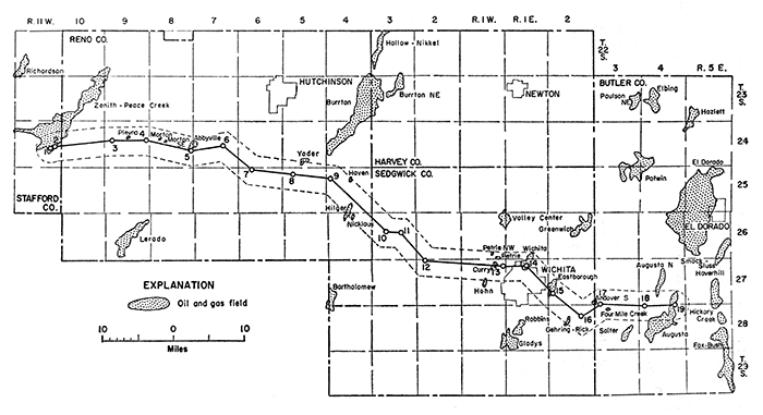
Exploration for oil and gas in the area adjacent to this cross section began about 1904, and discovery of oil and gas in commercial quantities was first made in the Augusta field in 1914 (Berry and Harper, 1948, p. 213, 215). Many additional fields have been discovered since 1914, and the location of these fields along the cross section and in adjacent areas is shown on Figure 1. Data on the oil and gas production from the fields located either entirely or partly within 2 miles of the cross section are summarized in Table 2.
Figure 1--Map showing oil and gas fields within 2 miles of the cross section and selected fields in adjacent areas. (Modified from Goebel and others, 1960, pl. 1 and 2.)
Oil or gas is produced from rocks of Pennsylvanian, Mississippian, Devonian, and Ordovician ages in the fields listed in Table 2. The largest production, however, has been from the rocks of Ordovician age. Rocks of Permian age below the Sumner Group include much limestone and some sandstone in the lower part, but production of oil or gas from these beds has been very small in the area adjacent to the cross section. Berry and Harper (1948, p. 220) report small amounts of helium- and nitrogen-bearing gas in the Augusta field at depths of 450 to 550 feet. This gas is probably from rocks of the lower part of the Council Grove Group and the Admire Group. In the El Dorado oil and gas field, located on the Nemaha Anticline several miles north of the Augusta fields, Fath (1921, p. 76) recorded a small amount of oil production and a show of gas from rocks that seem to be in the Admire Group.
Table 2--Oil and gas production within 2 miles of cross section as of December 31, 1959 (data from Goebel and others, 1960).
| Field and year of discovery |
Location of discovery well |
Cumulative oil production to Dec. 31, 1959, thous. bbl. |
Producing rocks and age |
Approximate depth to producing zones, ft. |
Principal production |
||
|---|---|---|---|---|---|---|---|
| Sec. | T. | R. | |||||
| Butler County | |||||||
| Andover South (?) | 31 | 27S. | 3E. | -- | Stalnaker sand of local usage, Pennsylvanian | 2,006 | Gas |
| Augusta (1914) | 21 | 285. | 4E. | 39,784 | Shawnee and Douglas Groups, Pennsylvaniana | 1,400 | Gas |
| Lansing Group, Pennsylvanian | 1,700 | Oil, Gas | |||||
| Kansas City Group, Pennsylvanian | 2,000 | Oil | |||||
| Marmaton Group, Pennsylvanian | 2,200 | Oil | |||||
| Simpson Group, Ordovician | 2,445 | Oil | |||||
| Arbuckle Group, Cambrian and Ordovician | 2,600 | Oil | |||||
| Augusta North (1914) | 28 | 27S. | 4E. | 15,306 | Lansing Group, Pennsylvanian | 1,650 | Oil |
| Kansas City Group, Pennsylvanian | 1,950 | Oil | |||||
| Simpson Group, Ordovician | 2,380 | Oil | |||||
| Arbuckle Group, Cambrian and Ordovician | 2,410 | Oil | |||||
| Four Mile Creek (1951) | 5 | 28S. | 3E. | 254 | Simpson Group, Ordovician | 3,069 | Oil |
| Reno County | |||||||
| Abbyville (1927) | 24 | 248. | 8W. | 1,072 | Kansas City Group, Pennsylvanianb | 3,540 | Oil |
| Haven (1951) | 9 | 25S. | 4W. | 29 | Simpson Group, Ordovician | 3,977 | Oil |
| Hilger (1934) | 16 | 265. | 4W. | 4,855 | Viola Limestone, Ordovician | 4,062 | Oil |
| Morton (1942) | 17 | 248. | 8W. | 54 | Lansing and Kansas City Groups, Pennsylvanian | 3,180 | Oil |
| Morton Southeast (1951) | 16 | 248. | 8W. | 18 | Lansing and Kansas City Groups, Pennsylvanian | 3,423 | Oil |
| Nicklaus (1952) | 3 | 265. | 4W. | 181 | Lansing and Kansas City Groups, Pennsylvanian | 3,249 | Oil |
| Plevna (1959) | 15 | 248. | 9W. | -- | Rocks of Mississippian age | 3,765 | Gas |
| Yoder (1935) | 34 | 245. | 5W. | -- | "chat", Mississippian | 3,402 | Gas |
| 93 | "chat", Mississippian | 3,450 | Oil | ||||
| Sedgwick County | |||||||
| Curry (1947) | 11 | 27S. | 1W. | 716 | Lansing and Kansas City Groups, Pennsylvanian | 2,715 | Oil |
| Eastborough (1929) | 19 | 27S. | 2E. | 9,186 | "chat", Mississippian | 2,956 | Oil |
| Viola Limestone, Ordovician | 3,238 | Oil | |||||
| Gehring-Rick (1952) | 16 | 285. | 2E. | 23 | Rocks of Mississippian age | 2,950 | Oil |
| Hohn (1945) | 22 | 27S. | 1W. | 149 | Lansing and Kansas City Groups, Pennsylvanian | 2,779 | Oil |
| Petrie (1945) | 36 | 26S. | 1W. | 157 | Viola Limestone, Ordovician | 3,387 | Oil |
| Petrie Northwest (1951) | 35 | 265. | 1W. | 42 | Viola Limestone, Ordovician | 3,445 | Oil |
| Wichita (1957) | 4 | 27S. | 1E. | 871 | Viola Limestone, Ordovician | 3,325 | Oil |
| Simpson Group, Ordovician | 3,345 | Oil | |||||
| Stafford and Reno Counties | |||||||
| Zenith-Peace Creek (1937) | 23 | 24S. | 11W. | 40,345 | Lansing and Kansas City Groups, Pennsylvanian | 3,481 | Oil |
| Misener sand, Devonian and Mississippian | 3,800 | Oil | |||||
| Sylvan Shale (Maquoketa Shale of eastern Kansas), Ordovicianc |
3,830 | Oil | |||||
| Viola Limestone, Ordovician | 3,860 | Oil, Gas | |||||
| a Production is listed by Berry and Harper (1948, p. 220) from Douglas Group but is in part from the Oread Limestone of the Shawnee Group. b. Kansas Geological Society, 1956. c. Imbt, 1941. |
|||||||
Oil that has been produced in large amounts from rocks of Pennsylvanian age in fields on or near the cross section is primarily from porous, locally oolitic limestones in the Lansing and Kansas City Groups. Gas has been produced in the Augusta fields from the Oread Limestone of the Shawnee Group of this report and from sandstone in the Douglas Group, and shows of gas have been found in the rest of the Shawnee Group (Berry and Harper, 1948, p. 220). In the El Dorado field, oil or gas has been produced from beds of sandstone and limestone currently placed in the Wabaunsee, Shawnee, and Douglas Groups (Fath, 1921, p. 77-81; Reeves, 1929, p. 166). The Marmaton Group has yielded some oil in the Augusta fields (Berry and Harper, 1948, p. 222), and lenses of sandstone in the Cherokee Group have been the reservoir of much oil in areas east of the cross section (Bass, 1936). Oil or gas production from the chert conglomerate at the base of the Cherokee Group is locally included with production from rocks of Mississippian age because of the difficulty in separating the conglomerate from underlying weathered chert of Mississippian age.
The rocks of Mississippian age yield oil or gas in four fields along the cross section and in numerous other fields in the north-central part of the Sedgwick Basin. The producing zone in many of the fields, commonly called the "Mississippi chat" by drillers, is weathered chert that is porous and tripolitic in part. Oil shows or staining was reported in drillers logs or was seen by the author in the samples from the "chat" in wells 3, 4, 8, 15, and 16.
The Misener sand, which lies at the base of the Chattanooga Shale of Devonian and Mississippian age, has yielded oil in the southern part of the Zenith-Peace Creek field on the southeastern flank of the Central Kansas Uplift. This field, which was discovered by the drilling of well 1 of the cross section, is a stratigraphic trap that is productive from the Misener sand, the Sylvan Shale, and the Viola Limestone (Imbt, 1941; Kornfeld, 1943). Well 2, also located in the Zenith-Peace Creek field, probably produced oil from the Misener. No oil shows or stains were seen or reported in the Misener in the other wells on the cross section.
The Hunton Group of Silurian and Devonian age was not identified on the cross section, but petroleum production from these rocks has been reported from several fields in the northern part of the Sedgwick Basin, especially along the Voshell Anticline.
Rocks of Ordovician age that yield oil or gas in fields near the cross section include the Sylvan Shale, Viola Limestone, Simpson Group, and Arbuckle Group. Oil has been produced from porous dolomite and dolomitic limestone in the lower part of the Sylvan Shale in the southern part of the Zenith-Peace Creek field (Imbt, 1941, p. 147). One of the most prolific oil reservoirs is the Viola Limestone, which has been found productive in six fields along the cross section. The Simpson Group yields oil in five fields, the larger of which are the Augusta and Augusta North fields. A large amount of oil has been produced from the Arbuckle Group in the Augusta and Augusta North fields, but this group has yielded little or no oil in the other fields along the cross section. Part of the oil production assigned to the Arbuckle Group may be derived from strata tentatively correlated with the Bonneterre Dolomite of Cambrian age, which is included in the Arbuckle Group by many geologists.
A large part of the Paleozoic rocks beneath the Wellington Formation of Early Permian age consists of limestone, dolomite, and sandstone, and these rocks are potential reservoirs for oil and gas where conditions of porosity, permeability, and structure are suitable. Future petroleum production is likely to be controlled in great part by variations in porosity and permeability, and structural closure probably will be of secondary importance.
Bass, N. W., 1936, Origin of the shoestring sands of Greenwood and Butler Counties, Kansas: Kansas Geol. Survey, Bull. 23, 135 p. [available online]
Bayne, C. K., 1956, Geology and ground-water resources of Reno County, Kansas: Kansas Geol. Survey, Bull. 120, 130 p. [available online]
Berry, G. F., Jr., and Harper, P. A., 1948, Augusta field, Butler County, Kansas; in, Structure of typical American oil fields--a symposium (Alexander Watts McCoy Memorial Volume): Tulsa, Okla., Am. Assoc. Petroleum Geologists, v. 3, p. 213-224.
Bunte, A. S., and Fortier, L R., 1941, Nikkel pool, McPherson and Harvey Counties, Kansas; in, Stratigraphic type oil fields--a symposium: Tulsa, Okla., Am. Assoc. Petroleum Geologists, p. 105-117.
Farquhar, O. C., 1957, The Precambrian rocks of Kansas: Kansas Geol. Survey, Bull. 127, pt. 3, p. 49-122. [available online]
Fath, A. E., 1921, Geology of the Eldorado oil and gas field, Butler County, Kansas: Kansas Geol. Survey, Bull. 7, 187 p. [available online]
Goddard, E. N., chm., and others, 1948, Rock-color chart: Natl. Research Council [2d printing by Geol. Soc. America].
Goebel, E. D., Hilpman, P. L., Beene, D. L., and Noever, R. J., 1960, Oil and gas developments in Kansas during 1959: Kansas Geol. Survey, Bull. 147, 254 p.
Imbt, W. C., 1941, Zenith pool, Stafford County, Kansas, an example of stratigraphic trap accumulation; in, Stratigraphic type oil fields--a symposium: Tulsa, Okla., Am. Assoc. Petroleum Geologists, p. 139-165.
Jewett, J. M., 1945, Stratigraphy of the Marmaton Group, Pennsylvanian, in Kansas: Kansas Geol. Survey, Bull. 58, 148 p. [available online]
Jewett, J. M., 1959, Graphic column and classification of rocks in Kansas: Kansas Geol. Survey, chart.
Kansas Geological Society, 1956, Kansas oil and gas pools, v. 1, South-central Kansas: Wichita, 96 p.
Kerober, R. P., and Kirby, J. J., 1948, Upper Cambrian and Lower Ordovician rocks in Kansas: Kansas Geol. Survey, Bull. 72, 140 p. [available online]
Koester, E. A., 1935, Geology of central Kansas uplift: Am. Assoc. Petroleum Geologists Bull., v. 19, p. 1405-1426.
Kornfeld, J. A., 1943, Peace Creek field [Kans.], a stratigraphic trap: World Petroleum, v. 14, no. 13, p. 38-47.
Latta, B. F., 1950, Geology and ground-water resources of Barton and Stafford Counties, Kansas: Kansas Geol. Survey, Bull. 88, 228 p. [available online]
Lee, Wallace, 1949, Subsurface geologic cross section from Barber County to Saline County, Kansas: Kansas Geol. Survey, Oil and Gas Inv. 8, Prelim. cross section, 16 p.
Lee, Wallace, 1953, Subsurface geologic cross section from Meade County to Smith County, Kansas: Kansas Geol. Survey, Oil and Gas Inv. 9, Prelim. cross section, 23 p.
Lee, Wallace, 1956, Stratigraphy and structural development of the Salina Basin area: Kansas Geol. Survey, Bull. 121, 167 p. [available online]
Lukert, L. H., 1949, Subsurface cross sections from Marion County, Kansas, to Osage County, Oklahoma: Am. Assoc. Petroleum Geologists Bull., v. 33, p. 131-152.
Maher, J. C., 1959, The composite interpretive method of logging drill cuttings: Oklahoma Geol. Survey, Guidebook 8.
Merriam, D. F., 1960, Preliminary regional structural contour map on top of Mississippian rocks in Kansas: Kansas Geol. Survey, Oil and Gas Inv. 22, map.
Mitchell, J. G., and Maher, J. C., 1957, Suggested abbreviations for lithologic descriptions: Am. Assoc. Petroleum Geologists Bull., v. 41, p. 2103-2107.
Moore, R. C., and Landes, K. K., 1937, Geologic map of Kansas: Kansas Geol. Survey.
Reeves, J. R., 1929, El Dorado oil field, Butler County, Kansas; in, Structure of American oil fields--a symposium: Tulsa, Okla., Am. Assoc. Petroleum Geologists, v. 2, p. 160-167.
Verville, G. J., 1958, Rock formations of Elk County, pt. 1 of Geology, mineral resources, and ground-water resources of Elk County, Kansas: Kansas Geol. Survey, v. 14, p. 5-27.
Williams, C. C., and Lohman, S. W., 1949, Geology and ground-water resources of a part of south-central Kansas, with special reference to the Wichita municipal water supply: Kansas Geol. Survey, Bull. 79, 455 p. [available online]
Next Page--Detailed sample logs
Kansas Geological Survey
Placed on web April 18, 2013; originally published in 1963.
Comments to webadmin@kgs.ku.edu
The URL for this page is http://www.kgs.ku.edu/Publications/Bulletins/OGI28/index.html