
Report of the Geological Survey of Miami County, Kansas
by G.C. Swallow and F. Hawn
Originally published in 1865 by the Journal of Commerce Steam Printing House, Kansas City, MO, this is one of the earliest geological reports produced in Kansas. George C. Swallow was the second state geologist of Kansas.
This online version presents a facsimile version of the original as well as the text of the report. The information has not been updated.
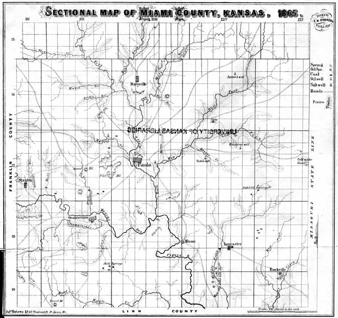
Figure--The map above is also available as an Acrobat PDF file--Sectional Map of Miami County (1.9 MB PDF file).
Facsimile Version of Report
- Main Report (32.6 MB PDF file)
- Sectional Map of Miami County (1.9 MB PDF file)
Geological Report
Miami County covers an area of about 600 square miles in latitude 38° 30' N., and longitude 95° W., and near the center of the eastern boundary of Kansas. Its surface is a high rolling prairie, intersected by numerous streams and broad valleys. The high prairie ridges wind and curve in every imaginable form, and sweep by gentle slopes down into the broad winding valleys, which are intersected by numerous timber-skirted streams, and dotted here and there by picturesque mound-like hills. Such are the general features which render this country beautiful in the extreme.
When we descend into an examination of rocks, soils, streams, springs, forest and prairie, we shall find the utility of the minuter details as striking as the beauty of the general outline.
Geological History
The limestones of this region were formed in the ocean, as is fully proved by the animal remains found in them; for these animals are such as lived in the ocean, and no where else. When, by geological changes, the country was raised above the water, its surface was nearly level and somewhat higher than the tops of the present hills and ridges.
In the process of time the valleys and ravines were worn out by the action of the surface waters and streams, leaving the present ridges and mound-like hills and ravines, with their sides and slopes, somewhat more abrupt than they are at the present time.
It was during this period that the beds of gray and brown clay, and fragments of rock, mostly flint, which rest upon the consolidated rocks of the coal measures, were formed from the harder materials of the rocks worn and swept away by the waters of that period.
We know but little of the history of this period of denudation, save that the waters must have been abundant and the streams powerful, to have worn such deep broad valleys and borne away the materials. If any animals and plants lived here during this period, their remains have been swept away and destroyed; as no evidence of their existence has been found. Subsequently this whole region, Eastern Kansas and Nebraska, Iowa, Illinois, Indiana, Ohio, Missouri, and parts of Kentucky, was covered by a vast fresh-water lake.
In this lake was formed or deposited the beds of gray and brown marl, which underlie and form the basis of the rich soils in all this vast region. Shell fish, such as occupy our present waters, lived in this lake. Forests of Elm, Sycamore, Walnut, Oak and other trees like those of our present forests, grew upon the shores of this lake. The Squirrel, Beaver, Deer, Elk, Buffalo, Elephant and Mastodon lived in the forest upon its borders.
The history of these times is found in the petrified wood and shells and bones of the trees and animals of those days, carefully laid away in the marl beds or bluff formation tieposited in this lake, and which are from time to time brought to light by examinations of these beds and their contents.
The remains brought to light by the examinations in Pompeii, Herculaneum and Nineveh, do not tell the history of those cities more accurately than the petrified trees and shells and bones exhumed from the marls of the bluff formation, tell the history of this lake and its shores.
By some changes of the succeeding ages the lake was drained away, exposing the surface of the earth somewhat changed. The marls deposited in the lake had for the most part covered up the limestones, and sandstones and shales, partially filled the deepest valleys, rendered the slopes more gentle, and smoothed up the rugged and precipitous hillsides, presenting a contour of surfaces of valley and hill substantially such as it has remained to the present time.
The streams, it is true, have cut their channels into the surface marls, and in some instances into the solid rocks below, and the waters have cut ravines and carried away some of the surface materials; but the contour of the surface remains substantially as it was left by the waters of the lake. As a matter of course a rank growth of weeds, grass and trees sprung up on the rich marls left by the receding waters.
Then was the broad area, once occupied by the lake, one unbroken prairie. Fires swept over the surface and killed out the young trees and such other plants as could not endure the annual burns.
Thus it is seen that prairie is the normal state, and the question should be, how the forests were formed? and tiot, what made the prairies? But there were ravines and wet places which the fire did not reach, and there the trees grew apace and produced the present forests. Meanwhile the fish and reptiles occupied the present streams and lakes, and the animals became the dwellers of the forests and prairies. Animals and plants died and decomposed, and formed a, black matter which mingled with the surface marls and formed the soil, the last and most valuable of the geological formations. The soil by this process is formed exceedingly slow; but the increase is as sure as it is that animals and plants will die and decay, and the waters fall and run, and the winds blow, and the animals walk and burrow and dig, and thus mingle the decaying matter and the loose surface deposits. Slow as is the process, the long period since that lake was drained away, has been ample for the formation of the deepest and richest soil of the continent. Such is a brief history of the changes which have transpired since the carboniferous seas retired from our part of the continent. The record, distinct and definite, has been impressed upon the rocks, where it must remain as imperishable as the foundations of the earth itself. There is a great variety of details in this record, which w,e have no time or space to relate. It might be interesting to consider the vast number of fishes that lived in the carboniferous seas, their names and varied habits, how the waters ebbed and flowed and ripple-marked the sandy shores; what tropical suns poured down upon dense steaming forests of Palm and Fern; and how rank vegetation sunk beneath the waters and formed the coal beds for man's use, but the utilitarian relations of these rocks claim our present attention.
Section of the Rocks in Miami County
Surface Deposits
No. 1.--1 to 6 feet Soil. The soil in this County is usually a rich calcareous loam, made up by mixing decayed organic matter with the marls of the bluff formation below.
No. 2.--1 to 20 feet Bluff. This is the fine buff and gray silicious marl which is commonly known as the "Surface Clays." This formation was deposited in a fresh-water lake, which once covered a large portion of the Mississippi Valley, and is the basis of nearly all the soils of this rich agricultural region.
No. 3.--2 feet Drift. There is found in many places in the county, between the bluff and the underlying carboniferous rocks, an irregular bed of gray sandy clay and water-worn fragments, mostly flint, of the underlying rocks. This formation sometimes comes so near the surface that the flint pebbles mingle with the soil, as seen near Miami and in other localities.
Coal Measures
No. 4.--2 feet Black Slate or Bituminous Shale. This rock was exposed in Mr. B. H. Stiles' well, south of Spring Hill. It was not seen in any other locality.
No. 5.--9 feet Buff Limestone. This rock was passed through in Mr. Stile's well, south of Spring Hill. The only locality in which it was seen.
No. 6.--9 feet Shale and Sandstone. This is a dark bluish gray hard sandstone, with graylsh blue shades. It was also exposed in Mr. Stile's well, south of Spring Hill. It was seen nowhere else.
No. 7.--28 feet Stanton Limestone. The upper portions are usually thick beds of soft light gray magnesian limestone, full of small brown ferruginous spots having, when exposed, small water-worn holes in the fragments. This part is more or less filled with plates and spines of Echinoderms, some Fusilenas and Productus magnus, still more rare. The beds below are regular, of medium thickness, harder and often very full of a variety of Terebratula subtilita. The beds still lower are bluish gray, weather brown, and separate into angular fragments by plane or conchoidal fractures.
This limestone is well exposed in the eastern bluffs of the Marais des Cygnes, in the highest points north of the "Devil's Backbone," above Stanton. It also appears at Coldwater Grove, and in all the highest ridges between those points, and in numerous places in the north part of the County, as Cave Springs and Buzzard Roost.
The cave at Cave Spring, south of Spring Hill, and the Sink Holes near Wea Cave, and at Coldwater Grove and other places, descend into this rock, the upper portions of which are so soft and porous, that the water has worn out the holes and cavities so characteristic of this formation.
No. 8--15 to 28 feet Sandstone. This is usually a hard gray calcareous sand rock in thin beds, passing into shales and fire-clays at top and bottom, but in places, it is a brown soft micaceous sandstone.
No. 9.--20 to 30 feet Cave Limestone. This rock is usually a hard brown brittle limestone, in beds of medium thickness, and separated into fragments by numerous vertical fractures. Some of the beds are gray and drab, with brown specks and blue concretionary nodules disseminated through the mass. It usually has brown cherty beds at the top and irregular masses in and between the beds below.
It contains Sp. cameratus, hemiplicata, and lineatus ; Productus costatus, Flemingii, Rogersii, punctatus, cora, semireticulatus and aequicostatus; Terebratula subtilita, and millepunctata; Euomphalus, Crinoids, Stenopora, Gorgonias, Zaphrenetis and Fucoids. When near the surface it forms deep percipitous ravines and steep sharp ridges. It also contains many caves and crevices from which bold springs usually flow.
This limestone forms the "Devil's Backbone," north of Stanton. It contains the Wea Cave and is exposed above the spring at Coldwater Grove, at McFaddins,' at Ward's Mill, and in other places in the central part of the County. It goes beneath the surface in the north and runs out in the south part of the County.
No. 10.--35 to 60 feet Einstine Sandstone. This is usually made up of thin beads of soft brown micaceous, and hard gray calcareous ripple-marked Sandstones, more or less intercallated with and passing into blue and brown sandy argillaceous shales. The upper part is marly and fossiliferous at McFaddin's and at Ward's Mill. This rock in places contains numerous fragments of vegetables which are sometimes converted into Coal, bituminous or char, and more rarely by asphaltum. Spirifer cameratus, Productus cora, Chonetes mesoloba, two species Stenopora, and fragments of Crinoids were found in the marly shales at the top of this formation. This Sandstone is usually more or less impregnated by Petroleum, and in many places it is so completely saturated with the oil, that it runs out and flows over the water and fills the air with its peculiar odor. The oil spring in section 29, township 17, range 25, comes to the surface over this rock.
It also appears saturated with Petroleum in the S. E. quarter of section 11, township 17, range 24, and other places.
No. 11.--2 feet Gray Limestone. This rock is usually a hard ringing, light gray, fine grained, pure limestone, filled with limpid particles and plates of Calc Spar. It also contains irregular masses of brown ferruginous matter. The beds are thin and very irregular. Spirifer lineatus, Productus Flemingii, Avicula, Terebratula subtilita, and fragments of Crinoids were observed in this rock.
This Limestone usually lies on the slopes of the ridges in the middle portions of the County in white water-worn masses. It will burn easily into a pure white lime.
No. 12.--12 to 18 feet Sandstone. This is usually a soft brown and gray micaceous, thin bedded sandstone, more or less saturated with Petroleum, as seen in the well of Mr. Thomas Dennis, on the farm of Dr. J. W. Gossitt, and in N. E. quarter sec. 36, township 17, range 24.
No. 13.--3 to 5 feet Shale. This is generally a blue and brown sandy Shale.
No. 14.--4 to 8 inches Coal. This coal is of medium quality and is sometimes used by the smiths, but is too thin to be worked with profit. It was observed in Sec. 31, township 17, range 28, and in Secs. 18 and 19, township 18, range 28. It also crops out in the two townships west of that last named. This Coal, like most of the thin beds in the upper Coal Measures, is not permanent.
No. 15.--2 to 4 feet Fire Clay. This rock is usually bluish gray and somewhat sandy. The place occupied by the last four divisions, Nos. 12, 13, 14 and 15, is sometimes filled by a bluish brown Shale or Fire Clay filled with marly concretions, usually rough and elongated, as if formed from fucoidal remains; as seen at the spring west of Mr. Daniel Peery's house. At other places this space is occupied by sandstones and shales; as seen near the ford, north-east of Ossawattomie. At the last locality, these beds are 24 feet thick, but at Peery's Spring, they are only 12 feet thick; while below Beaver Creek Oil Spring they are 32 feet. As a general rule the 4 thickness increases in proportion as the sandstone replaces the shales, or as the arenaceous matter takes the place of the argillaceous.
No. 16.--2 to 4 feet Spring Rock. This is a hard bluish gray fine grained limestone, containing many fossils and crystalline particles of calc spar. When exposed it changes brown, and parts into slightly rhombic parallelograms, which finally separate into small angular fragments by plane and conchoidal fractures.
It contains Spirifer cameratus and lineatus, Productus Flemingii, Crinoid columns and plates, and Orthis umbraculum.
Many of the fine springs in the County come to the surface through crevices of this rock. The large spring below the Fort in Paola, the two near Mr. Peery's house, and many others might be mentioned. In fact, wherever this rock comes to the surface, we find springs more or less permanent; as the water percolating through the rocks cannot pass the shales below, it is forced through crevices of this limestone till it finds vent wherever the rock comes to the surface. This is true, in a greater or less degree respecting all the limestones in the County, and fully explains the fact that wells usually meet good water in passing through limestone. The oil spring in section 31, township 17, range 25, comes up through the joints of this limestone, but its source is doubtless in the sandstone below.
No. 17.--50 to 60 feet Sandstone and Shales. This rock is usually a gray thin bedded ripple-marked calcareous sandstone, passing into argillaceous sandy shales of blue and brown color, with beds of carbonate of iron at top and bottom, as seen at Beaver Creek Springs: but is very variable. Near the ford north-east of Ossawattomie, the upper part is blue, purple and brown argillaceous shales, with thin beds of carbonate of iron, while on the Walnut west of Paola, the upper beds are a soft, brown micaceous sandstone, containing many impressions of vegetable remains. Near Rockville the lower part of this rock is sandy and oleaginous.
This formation everywhere shows more or less indications of the presence of Petroleum. The famous "Wea Tar Spring" comes to the surface near the top of this rock, and the Beaver Oreek Tar Spring, comes from the middle; and Petroleum was very abundant and troublesome in several wells sunk in the lower part of this rock, near Rockville.
A thin bcd of Coal sometimes appears in the lower part of this sandstone; as seen in a branch south-east of Stanton.
No. 18.--5 to 7 feet Blue Limestone. This formation is made up of hard, blue, compact limestone and flint, in places, with partings of blue and drab shales. Some of the beds are bluish gray, and some are filled with a broad lobed Sperigera; Spirifer lineatus is less abundant, and Productus Flemingii and Ter. subtilita are sometimes found. At the crossing of the Wea, on the Rockville Road, these rocks are 5 feet thick without shale partings; or, at least, the partings are very thin. These beds are found in the wells north of Rockville, and in Mr. Heimer's well, south-west of that place. A strong stream of water flows through them.
No. 19.--13 feet Blue Shales. This rock is fully exposed at the Wea, where the Rockville road crosses. It is made up of blue and drab argillaceous shales, commonly called soapstone.
No. 20.--15 to 20 feet Well Rock. The various parts of this limestone present very distinct characteristics. The upper beds are a whitish gray, soft magnesian limestone, sometimes called "cotton rock." It is a good fire-rock and is used for chimneys and fireplaces. The middle beds are bluish gray and drab, hard compact or crystalline. In places it is a hard drab compact, thin-bedded argillaceous limestone, filled with hard blue concretionary or fucoidal masses. The lower part is usually a bluish gray cherty sub-crytalline limestone, weathering brown and parting into small angular masses. The beds are irregular with thin shaly partings.
Spirifer cameratus, Kentuckensis and lineatus; Productus Flemingii, costatus, and Punctatus; Terebratula subtilita, and millepunctata; Enomphalus, a small species; Chonetes mesoloba; Myalina, Crinoids and Nantilus nododorsata, are found in this rock.
The salt water in the wells at Ossawattomie comes from this rock; but I found no indications of salt water where the rock comes to the surface. This rock is exposed at Lykin's well, at the crossing of the Wea on the Rockville road, at the crossing of Middle Creek and North Sugar on the same road, at the ford of Bull Creek west of Paola, at the fords of Marais des Cygnes, and Pottawattomie near Ossawattomie, and on all the streams in the southern part of the county.
No. 21.--6 to 10 feet Blue Shales. This rock appears to be very variable in thickness. It is exposed at the Chestnut ford on the Pottawattomie below the Well Rock.
No. 22.--1 1/2 feet Blue Limestone. This is a hard, compact, blue and bluish-gray limestone, in thin beds, with shale partings. It is exposed on Sugar Creek, N. E. of Rockville, and on the military road still farther to the N. E. Spirifer lineatus was observed in it.
No. 23.--6 feet Bituminous Shales. This rock is made up of thin, hard plates of black argillaceous matter, fully saturated with bitumin. It burns readily in the fire, leaving a large amount of gray ashes.
Discina Convexa was found in this rock. It is exposed near the Won-Zop-peah Tar Spring, and other places in the southern part of the county.
No. 24.--1 to 2 feet Blue Limestone. This is a hard, compact, brownish-blue limestone, containing some particles and blue veins of brown calc spar. It contains Chonetes mesoloba, (?) and a small Machrocheilus. (?) It receives a fine polish, and is said to contain ores of the precious metals; but all expectations founded on this report will be disappointed. It crops out near Lykin's well, and near the Won-Zop'peah spring.
No. 25.--1 foot Blue Shales. This bed is exposed in the ravine above Won-Zop-peah spring.
No. 26.--18 feet Limestone. The upper part is a hard, compact, bluish drab limestone, filled with purple spots or concretions; the middle portion of the limestone is coarser and filled with small, brown, ferruginous particles and cavities. The lower part is usually a hard, silicious sub-cryataline limestone, with numerous small, brown, ferruginous specks. Below the last is sometimes found a bed of light drab, hard magnesian limestone, with a three lobed Terebratula. In most localities the middle portion is a hard, fine gray, sub-crystaline chirty limestone, which weathers brown and separates into angular fragments.
It contains small white crystals of calc spar, Productus punctatus, Rogersii, costatus, cora, semireticulatus and Flemingii; Spirifer lineatus and cameratus; Chonetes smithi (?) and numerous Crinoidal remains were found in it.
This is the lowest limestone in Miami county; it crops out at the Won-Zop-peah spring, on Sugar creek near Rockville, and in all the deep ravines in the southern part of the county. It does not come to the surface in the middle and northern part.
No. 27.--150 to 200 feet Sandstone and Shales. The upper portion of this formation is usually a dark, heavy bedded, soft, micaceous sandstone, more or less saturated with petroleum. In places, it passes into gray, hard thin beda of calcarous sandstone and bluish sandy shales, and sometimes, lower down, into beds of brown and blue sandy shales, with a few thin strata of kidney iron ore. It contains some impressions of vegetable remains. It is the lowest rock exposed in Miami county. All the deep ravines in the southern part of the county cut into this sandstone.
The Won-Zop-peah, the Honeywell, the Rockvllle, Mascoes, Godfrey, Sac Ford, and all the other oil springs and indications in the low grounds in the extreme southern part of the county, come from the upper part of this rock. The exact thickness of this formation could not be determined by any data we could obtain in this county; but from the exposure and levels on Sugar creek in this and Linn county, it was judged to be at least 150 feet thick. Mr. W. B. Carter says his well at Ossawattomie, penetrated 170 feet without reaching the bottom.
No. 28.--5 feet Concretionary Marl. This is a blue and brown calcareous shale, with strata of large lenticular concretionary masses of hard, blue marl. This is doubtless a concretionary limestone in some places. In does not come to the surface in Miami county; but it is exposed over Kelley's coal bed in Linn.
No. 29.--13 to 33 inches Bituminous Coal. This coal is of medium quality; rich in gas, cakes well and burns with a clear flame.
It contains some sulphuret of iron and other impurities. It is exposed on Sugar creek, about 9 miles south of the Linn county line.
No. 30.--3 feet Fire Clay and Black Shales.
No. 31.--6 Limestone. This is a hard, bluish and brown, Impure argillaceous limestone, in thin, irregular beds. It contains Spirifer lineatus and cameratus; Fresilina cylindrica Zaphrenetis, and fragments of Crinoids.
Such are the rocks in their regular series, from the highest beds in the northern part of the county, to the lowest on Sugar creek, in the south-east, giving a total thickness, ranging from 315 feet to 350.
These rocks lie in a position nearly horizontal.
There are some local dips, as where the road from Paola to Olathe crosses the Ten Mile Creek, in the branch north of Rockville, and at the crossing of Marais des Cygnes, N. E. of Ossawattomie; but these dips are merely local and do not disturb the general level of the rocks in the County.
Economical Geology
Soil
The soil is the great source of individual and national wealth, as it is the immediate or remote source of nearly all the materials used to feed, clothe and shelter us. Its absolute value is beyond computation, as man is dependent upon it for existence. Its relative value depends upon its fertility, durability, and ease of cultivation. In these several respects, the soil of Miami is scarcely surpassed by any considerable areas in this or any other country.
Its fertility is abundantly indicated, on the prairie, by a rank growth of prairie grasses, Rosin Weed, or Compass Plant, (Silphium laciniatum) "Prairie Locust," (Amorpha fruticosa) and American Hazle; and in the forests, by the large growth of Hackberry, Elm, Walnut, Honey-locus, Wild Cherry, Ash, Pignut, Hickory, Sugar Maple, and Wild Grape and Plum; and is fully proved by the abundant crops of the staple article produced by the most ordinary cultivation.
The durability of this soil is fully established by its composition and depth, and the underlying beds of marl. As stated above, the fine silicious marls of the Bluff formation underlie and form the basis of the soils throughout this County. This marl, and the decayed animal and vegetable matter mixed with it, furniah an abundance of all the ingredients entering into the composition of the best soils.
Fields have long been in cultivation with but little show of exhaustion. But the natural exhaustion of the surface soil by a long succession of crops, can easily be repaired by running the plow deeper, and bringing some of the virgin sub-soil and marls to the surface. By this process the deteriorated surface soil may be readily and effectually recuperated, and made as good as new; and, besides, there is rich material enough below to repeat this process upon, as long as the present races will wish to cultivate. There is scarcely an acre of waste land in the County; the slopes are gentle and the soil good to the tops of the highest ridges.
The characteristics above named show the soil to be light and easy of cultivation. It is nearly all open, clean, undulating prairie, without broken ravines or steep declivities, and entirely free from rock and stumps. There are a few places where the flints of formation No. 3, of the above Section, come near the surface and mingle with the soil; but the area is very limited, and may be used for pasture. The only real difficulty felt by the farmers in this part of the State, is the droughts which sometimes prevail in the summer months. But this difficulty can be entirely overcome in all ordinary seasons by deep sub-soiling and early planting.
By a faithful use of the sub-soil plow, every few years, the soil will be rendered light and porous to so great a depth that the roots will penetrate much deeper, beyond the reach of the drying suns, and the moisture will rise by capillary attraction much more abundantly from the wet sub-soil below. And beside, the sub-soiled land is so much lighter that the excess of water in early spring drains off much quicker, and the land can be wolked and planted much earlier. By early planting, the crops are more firmly established and fully developed before the droughts of summer come on. When thus advanced, they form a better protection to the soil against the drying heat of the sun, and have more power and depth of root to withstand its effects.
There have been many cases in the neighboring States where deep plowing and early planting secured excellant crops, while the crops in the adjoining fields under the ordinary cultivation were failures through the excessive drought. We have seen several cases where the experiment was so successful, and the contrast so striking, that no one could fail to be convinced of the efficacy of the remedy.
It is also well established, by long and successful experiments, that deep or sub-soil plowing* secures far better crops in ordinary and wet seasons, as well as in dry ones. [*As a general rule the sub-soil should not be turned, on to the surface, but it should be stirred by a regular sub-soil plow, (following in the furrow of a common plow,) leaving the sub-soil in the bottom of the furrow to be covered by the next furrow of the common plow.]
It is firmly believed that a rigorous application of this system of culture will secure good crops on the good soils of Eastern Kansas even in the dryest seasons.
Salt
There are several dry salt licks in various parts of the County, but there are no indications to show whether valuable deposits of salt exist at those localities. Five wells have been bored at Ossawattomie, in all of which good brine was obtained. According to the facts given us by W. B. Carter, Esq., the wells are 186, 270, 86, 120 and 115 feet respectively in depth. The first brine was struck in all at the depth of 60 feet, and at 80 feet a stronger vein of salt water was reached. These veins of brine were in the lower limestones of the above Section, and in all of the wells were found at about the same levels, indicating a common origin in these rocks.--But a careful examination of the limestones in which the brine was found in these wells, where they crop out in hundreds of places in the middle and Southern portions of the County, did not reveal a single indication of the presence of salt, or salt water, rising from their beds.
The following Section gives the rocks passed through in sinking the wells at Ossawattomie, as given us by Mr. Carter:
No. 1.--22 feet, Soil and Clay. (Soil and Bluff Marls.)
No. 2.--9 feet, Soapstone. (Shales.)
No. 3.--13 feet. Blue Limestone and Clay.
No. 4.--15 feet, Gray Limestone and Clay partings. (Well Rock Nos. 20. 21 and 22 of our Section.)
No. 5.--Brine and Oil.
No. 6.--3 feet, Black Shale. (No. 23 of our Section above.)
No. 7.--7 feet, White Limestone. (No. 26 of our Section.)
No. 8.--170 feet, Soapstone. (Shales and Sandstone No. 27 of our Section.)
The strength of the brine ranges from 1 1/2° to 3 3/4° of the Pennsylvania Scale* for brine. The strength of the brine used for the manufacture of salt at this place averaged about 2° of the above scale. The salt manufactured is esteemed a very pure article. [*20° of this Scale represent a Saturated Solution.]
The works were not in operation when we visited them, and we could obtain neither salt nor brine. Dr. Sinks, the chemist of the survey, will analyze both and give the results in his general report.
There is no doubt that other veins of salt water will be penetrated by sinking these wells deeper, but there are no means of determining at what depth the brine will be reached, or in what quantities, or of what strength it will be found; as no investigations have been made deeper than these wells, in this part of the State. There is, however, a probability that strong brine in large quantities will be reached at the base of the carboniferous rocks, where the numerous and bold brine springs in Central Missouri come to the surface. How deep this horizon is below the present borings, we cannot tell till we have completed our survey of the South-Eastern part of Kansas, where we expect to find data for determining the thickness of the lowest carboniferous rocks of the State.
Petroleum
The existence of "Tar Springs" in Missouri and Kansas has long been known to the settlers and hunters of those regions, but they attracted no particular attention, as the "Rock Tar" had been applied to no useful purpose, except as a lubricator of the freighter's wagon and a limited application as a domestic medical remedy. The late extensive application in the arts, has caused to be made careful explorations of these localities, which have resulted in discovering a vast number of places where petroleum comes to the surface through the rocks and soils in greater or less abundance. Such in fact is the abundance of petroleum flowing from the springs in this County that no one can doubt that it comes from some abundant source.
In our examination of Miami County, more than twenty places were observed where petroleum flowed from the rocks and soils in considerable abundance. The larger number of these springs are, as shown on the accompanying map, on the Wea, Middle Creek, and Marais des Cygnes and Sugar Creek. There are numerous places in all parts of the County where the rocks are saturated with petroleum, or contain it in their cavities in the solid state, called asphaltum. There are also numerous wells in which petroleum was found in some of its varieties. In some it was so abundant as to entirely ruin the water, and the wells were filled up and abandoned.
The most noted Springs in the County are the "Wea Tar Spring," the "Beaver Tar Spring," the "Won-Zop-peah Tar Spring," "Dale's Oil Spring," and "Honeywell's Oil Spring."
The Wea Tar Spring is on the Wea, in Sec. 2, T. 17, R. 24, and flows from the partings and crevices of the sandstone No. 17 of our Section above, about 15 feet below the overlying limestone. This spring doubtless discharges more petroleum than any other in the county; and has been known to the settlers and freighters for more than 30 years, and to the Indians from time immemorial.
The Beaver Creek Tar Spring is in Sec. 8, of the same township, and springs from the same sandstone a few feet lower down, or 30 feet below the limestone No. 16. Dale's Oil Spring is in Sec. 30, T. 17, R. 25, and comes up through the Spring Rock, from the sandstone below, or No. 17 of our section. Honeywell's Oil Spring is in Sec. 33 of the same township, and both of these springs come out through the fractures of the sandstone of No. 27, of our section about 30 feet below the limestone No. 16. We saw some fifteen other springs, from which oil flows more or less freely, and numerous places where the sandstones are completely saturated with it, and where the shales and limestones contain it in cavities.
Some oil was obtained in the salt wells at Ossawattomie, in several wells in Paola, in Dennis,' Speaces,' Lykins,' and many other wells. Lykins' well was bored for oil in the S. E. quarter of Sec. 15, T. 17, R. 23, in 1860, under the direction of Mr. G. W. Brown, for Messrs. Brown, Solomon & Co. We could get no very reliable account of the borings, as the records are reported lost. Mr. S. S. Clover gave us the following as the facts in the case according to the best of his recollection:
The well is 275 feet deep, 25 to 30 feet limestone, and the remainder soapstones and sandstones and clays, with blue concretions containing pyrites, which was said to have some gold in it. At the depth of 150 feet the clay with concretions was reached 5 to 20 feet feet thick, and the last 50 feet was the same. "Got oil all the way down." It is supposed it would yield one barrel of oil per day, when the work closed on account of the troubles.
A St. Louis company formed under the auspices of Mr. Einstein, has just commenced boring on Sec. 11, T. 17, R. 24. When we were there they had reached a depth of 110 feet, with some oil. The work is now in progress with fair prospects and high hopes of success.
These various oil springs and other indications of petroleum have their origin in four different sandstones, Nos. 10, 12, 17 and 27, of our section, as given above. Each of these sandstones Is so saturated with petroleum, in places, that it runs out into the soil, or over the water and fills the air with its peculiar odor; and where there are fractures or crevices, the oil flows out in such abundance as to have acquired the name of "Oil" or "Tar Springs," Some of these localities are mentioned in the descriptions of those sandstones in the section above. There are other localities in these sandstones in this county and Linn, and in Bates and Cass counties, over the line in Missouri; but enough have been given to show the character and abundance of these manifestations of petroleum in this region.
Nearly all the petroleum seen was of the dark, thick, heavy variety. Iviiown in commerce as Lubricating Oil, which is much more valuable than the thin amber colored varieties.
The thin amber colored variety, Illiuminating Oil, was seen in places on the water in the branches, and particularly on the springs which come up through the surface marls and soils; and the solid variety, Asphaltum, was observed in numerous places in the cavities of the rocks and on the surface near the springs of the liquid varieties. Gas is more or less abundant at all the principal localities named.
Such are some of the facts observed daring the examination of Miami county, and it would seem they are sufficient to convince any one familiar with the indications and developments of petroleum in the productive oil regions of the country, that it must exist in large quantities in this county. The facts, that scarcely a well has been dug without finding petroleum in some of its forms; that four sandstones are in many places perfectly saturated with it; that more or less of it is found in the cavities of all the other rocks; and above all, that it has been flowing in considerable quantities from some score of springs from time immemorial, are, to say the least, very strong evidence of the existence of large reservoirs near those localities.
Coal
There are two thin beds of coal in our section, No. 14 and No. 17, which crop out in several places in the county; but the other bed, No. 29, is too low in the series of rocks to come to the surface in this county. It was observed on Sugar Creek, about 3 miles south of the county line. The upper bed, No. 14, is not permanent; as in many places it runs entirely out. It crops out in several places in Secs. 18 and 19, T. 18, R. 22, and in T. 17, R. 24. Its thickness ranges from 4 to 10 inches, and its quality is scarcely medium. It has been worked some, but is too thin to pay. The bed in No. 17 is still less permanent, and is not so thick. It crops out in Sec. 30, T. 17, R. 22. The only coal that can be worked to advantage in this county is No. 29, which crops out on Sugar Creek. It is a bituminous coal of medium quality, 33 inches thick where we saw it on the west side of the creek, on John Ross' land.
It is reported not so thick on the east side, on the land of the late Mr. Jacob Halderman.
This coal could be worked by shafts in any part of Miami county, unless by some very rare freak of nature it should thin out to the north and north west. It will be an easy matter to approximate the depth at which it will be found in any part of the county. The only source of uncertainty in estimating the depth, rests in the variable thickness of some of the beds of sandstone and shales, as the limestones are very uniform in thickness. In the section, we have given the extreme measurements, the thickest and thinest parts, so far as observed. Half of the sum of these extremes will give the average thickness, which is the thickness to be used in estimating the depth of any given bed below any other bed in the series.
If we wish to determine the depth of this coal bed at Paola, at the level of the big spring under the fort, we first determine which rock in the section comes to the surface on a level with the spring, and then the average thickness of all the beds between that and the coal will give its depth near enough for all practical purposes. This spring comes out under the spring rock, No. 16. The rocks between it and the coal are Nos. 17-28 inclusive, whose average thickness is 307 feet, the depth of the coal of No. 29, below the level of the spring above named.
At the ford over Bull Creek, west of Paola, the Well Rock, No. 20, is at the surface, and the average thickness of the beds, No. 20-28, between its surface and the coal, is 233 feet. In the same manner the depth of the coal may be determined at any other point.
As we remarked on page 12, it was impossible to determine the exact thickness of the sandstones and shales of No. 27, as a portion of it was covered up in Sugar Creek, the only place where we saw the bottom of it. But we shall be able to do this when the survey of Linn county is completed. The approximate thickness given is near enough for all practicable purposes of mining the coal beneath it; as a few feet more or less in a shaft will make but little difference in the expense of raising the coal, when the shaft is once completed. When the amount of coal raised is considerable, one cent per bushel will cover all the difference in expense between raising it 200 feet and raising 300 feet.
The only practical question remaining, which is by far the most important of all, is the amount that can be sold, and the price it will command. The price now demanded at the mine on Sugar Creek, 25 cents per bushel, is high enough, provided any considerable amount can be sold at those figures.
The only question then not settled with sufficient accuracy for all practical purposes, is whether this coal bed continues north and north west in sufficient thickness to be worked to advantage, and this will soon be determined by the wells sunk for oil and salt in various parts of the county.
Water
But few portions of the country are as well supplied with water as Miami county. A glance at the map will show that every part of it is intersected by creeks and rivers. A vast number of bold perennial springs flow from the rocks in all parts of the county. These supply their respective neighborhoods and fill the streams with a never-failing abundance of pure water.
Timber
Timber is an item of primary importance in the prairie States of the West, and especially so in Kansas. But as indicated by the map, the streams in all parts of Miami county are skirted by magnificient forests of the very best timber of the deciduous species. There is an abundance for all farm and domestic purposes, and that, too, so distributed as to be convenient to every neighborhood.
Cottonwood, Sycamore, Honey Locust, Black and White Walnut, White Pig-nut, and Shell-bark Hickory, Red and White Elm, Linn, Red Birch, White and Blue Ash, Burr, White, Chestnut, Black, Gray, Post, Bed, Pin and Chinguapin Oak, Box-Elder, Mullberry, Coffeebean, Persimmon, Hop-hornbeam, Grapes, Haws, Wild Plums, and other species of less importance occur as large and well developed as usual in the timbered States of the West. With economy in the use, and ordinary care in preserving the timber, the county need never want for this article of primary necessity.
Building Materials
Good limestone exists in sufficient quantities for buildings, fences, and all other farm and domestic purposes.
The gray limestone, No. 11, and some of the beds in each of the limestones, Nos. 7, 9, 16 and 26, will burn into strong white quick lime, suitable for plastering and cements.
Clays, suitable for bricks, are also found in various parts of the county.
The upper beds of the Stanton limestone, No. 7, and the white soft beds of the Well Rock, No. 20, and some of the sandstone in the upper part of No. 27, make good fire-rock, and are very suitable for fire-places and chimneys; as they are easily worked and durable, whether exposed to weather or fire. These limestones are exposed in nearly all parts of the county, and the sandstones in the southern part, on Sugar and Middle Creeks and other places, where these formations crop out; as shown in the description of these rocks in the section above.
Some of the beds of Nos. 10 and 27 have a sharp grit and fine structure, very suitable for grindstones and whetstones. There is a fine locality south of Rockville, in the bluff of Sugar Creek. Mr. Cameron had a good grindstone made from the sandstone at this locality.
Fruit
Apples, Pears, Peaches, Cherries and Plums, so far as tried, are doing well. They succeed well in the adjoining counties of Missouri where the climate and soil are the same, and there is no good reason why they should not do as well in this county. With such improved modes of cultivation as are adapted to dry rich soils, Gooseberries, Blackberries, Raspberries, Strawberries, and even Currants may be cultivated with great success.
All the ground for fruit culture should be thoroughly and deeply sub-soiled; and that in the small fruits above named, should be mulched with straw or prairie hay during the summer. All will do best on a northern exposure; and the Currants should be on the north side of a fence, where partially shaded by trees.
In a soil and climate so genial to the grape, it can scarcely fail of entire Success. The ground should be deeply sub-soiled or trenched, and the vines carefully pruned; as the great trouble will be too rank a growth from the richness of the soil. But careful pruning in view of the vigorous growth, will remedy the evils arising from this cause.
Iron ore
As noted above in the section, there are sundry beds of Kidney ore, carbonate of iron, in the shale beds in the county. But they do not appear in sufficient quantities to be of any present practical value. The future may develope wants which they will be suitible to supply.
Population
Miami county has a population of some 7,000, and is fast filling up with an enterprising population. Paola, the county seat, is a flourishing town, in a beautiful location on Bull Creek, near the center of the county. Ossawattomie, St. Marysville, Stanton, Miami, Fontana, New Lancaster, Rockville and Beavertown, are pleasant centers of populations in various parts of the county. The various improvements. whether farms, houses, churches or schools, all indicate a thriving, energetic and prosperous people.
Climate
While Kansas has the temperature of Delaware, Maryland, Virginia, Kentucky and Missouri, and the southern parts of Ohio, Indiana and Illinois, the high rolling surface in this part of the State renders the climate extremely pleasant and healthful.
It has been feared by some that Kansas is more subject to droughts than the older States in the Mississippi valley; but a careful examination of the amount of rain in the various Western States, as given by the records kept at the military posts and other points, show that as much rain has fallen in Kansas for the last forty years, as in Missouri, Illinois, Indiana, Ohio or Kentucky. We also have the testimony of the Indians, missonaries and others, who have lived in this State the last thirty years or more, that there has been no serious drought in their memories previous to 1860.
The following note from the Head Chief of the Kaskaskia, Peoria, Piankeshaw and Wea, Confederate Tribes, is a fair sample of the testimony collected from the old Indian farmers:
Paola, Miami Co., Kansas, Oct. 30th, 1865.
Prof. G. C. Swallow:
SIR--I have cultivated my farm in this county for thirty-five years, and have raised good crops every year but one, A. D. 1860; and have had no serious injury from droughts, previous to that year. The experience of other farmers in my tribes, is the same as mine in respect to crops and droughts.
(Signed) BAPTISTE PEORIA.
We thus have the testimony of those, who have lived here and cultivated farms, and the records, kept at the military posts, both showing that there had been no lack of rain in Kansas for at least thirty years previous to 1800; and that the drought of that year and partial one in 1864, are only such exceptions to the general rule as occur in all countries.
Such are the more important facts observed in our hasty examination of Miami county, and the most obvious practical applications to be made of them in the economical pursuits of life. Some of the practical questions can be more definitely settled when the rest of the State shall have been examined, but enough is known and definitely stated to prove this one of the best agricultural regions in the western country; with an abundant supply of water, timber and coal, and a fine prospect of a great source of wealth and prosperity in mineral oil.
We cannot conclude without expressing our greatful acknowledgments to the people of Miami county for their warm hospitalities and earnest co-operation in the Survey, and for the facilities so liberally furnished to make our labors pleasant and successful. It is scarcely possible to mention names without making invidious distinctions. Still, justice demands a public acknowledgment of the marked and enlightened liberality of the honorable members of the Board of County Commissioners, who provided funds for publishing a special report of their county; and of the citizens of Paola, who furnished the very best transportation and paid all expenses. The Survey is under special obligations to Hon. W. R. Wagstaff; and Mr. S. S. Clover, who greatly facilitated our labors by being our constant guide and by pointing out the most important localities. We are also indebted to Messrs. J. H. Pratt; A. O. McKenzie, G. W. Dale, W. T. Shiverly, and others for similar attentions. Such a people richly deserve the fair heritage they possess in their rich, beautiful Miami.
G. C. SWALLOW.