Kansas Geological Survey, Mineral Resources Circular 6, originally published in 1937
Prev--Letters A through F... ||
Next--Letters P through W...
Two thick limestone formations, the Florence, and Fort Riley, crop out over a large part of Geary County. The Winfield limestone occurs along the west border of the county and in the panhandle. Production of limestone for road metal and concrete was reported in 1935 by the city engineer of Junction City and by the government at the Fort Riley Military Reservation.
The Republican River, with a wide flood plain, extends from the northwestern corner of Geary County to Junction City, where it joins the Smoky Hill River which flows from southwest to northeast across the western end of the county. Adequate supplies of ground water are obtained by shallow wells into the flood plains of these two streams. Ground water is less abundant in the uplands.
The nearest gas production is the Wilsey field in central Morris County about 12 miles south of the Geary County line. The nearest oil field is the Lost Springs field in the northeast corner of Marion County, about 20 miles from the southwest corner of Geary County. Attempts to find oil and gas in Geary County have not been successful as yet, but the county has not been very thoroughly tested.
Sand and gravel are available in the beds of Smoky Hill and Republican rivers and have been exploited in the vicinity of Junction City.
The northern half of Gove County is covered with the Ogallala formation in which wells drilled to a moderate depth encounter an abundant supply of usable water. The southern half of the county is crossed from west to east by Smoky Hill River. Some water is available in the flood plain of this stream, but water is scarce in the Niobrara chalk that outcrops between the flood plain and the Tertiary-capped uplands to the north and south.
Two deep tests were drilled for oil and gas in Gove County during 1931. One, in sec. 11, T. 12 S., R. 27 W., was abandoned at a depth of 4856 feet without encountering any oil or gas shows. This well went into the Ordovician at 4550 feet and, the "Siliceous lime" at 4705 feet. The other well was drilled in sec. 24, T. 13 S., R. 27 W., to a total depth of 4813 feet. The top of the Ordovician was encountered at 4530 feet and the "Siliceous lime" at 4671 feet. A show of oil was obtained in the "Oswald lime" at 4065 feet. Oil occurs in commercial quantities in Trego County to the east and in Scott County to the southwest. Southwestern Gove County and the northeastern corner of the county were scenes of active leasing in 1936.
A deposit of unusually fine volcanic ash, containing an estimated 60 thousand tons, occurs about 10 miles southwest of Quinter on the east side of a southward-flowing tributary of Hackberry Creek. The State Geological Survey office contains no record of this deposit ever having been exploited.
Sand and gravel are abundant in southern Gove County along Smoky Hill River. Other deposits occur in the central and northern parts of the county along southeastward flowing tributaries of the Smoky.
Water supplies are obtained in Graham County from four sources: Valley fill, Ogallala formation, Codell sandstone, and Dakota sandstone. The south fork of Solomon River crosses the central part of the county from west to east. Farms and towns on the flood plain of this stream obtain water from shallow wells into the alluvium. Sheet water is available on the uplands north and south of the river in the Tertiary rocks of the Ogallala formation. Where the cover of Tertiary sediments is thin, and where the underlying Niobrara formation is exposed, deep wells are necessary. Water is obtainable in parts of central and eastern Graham County at depths in the neighborhood of 450 feet from the Codell sandstone, which lies immediatelx beneath the Niobrara, but this sandstone is erratic in thickness. The Dakota carries good and abundant water in this part of the, state. It is reached at depths of about 650 feet. In many cases the water rises in the well to within 100 feet of the surface.
Oil occurs in Trego County to the south and Rooks County to the east. Active leasing was underway in 1936 in the northeastern and southwestern parts of the county. Graham County is fairly high on the Central Kansas Uplift. Six dry holes have been drilled in recent years in this county. A few data in regard to these wells follow:
| Location | Date | Total Depth |
|---|---|---|
| Sec. 11, T. 9 S., R. 25 W. | October, 1931 | 4656 |
| Sec. 24, T. 8 S., R. 25 W. | September, 1933 | 4180 |
| Sec. 8, T. 10 S., R. 22 W. | October, 1935 | 4220 |
| Sec. 29, T. 8 S., R. 22 W. | July, 1936 | 3870 |
| Sec. 27, T. 10 S., R. 22 W. | November, 1936 | 4123 |
| Sec. 19, T. 10 S., R. 21 W. | November, 1936 | 3974 |
A deposit of unknown extent containing exceptionally fine volcanic ash occurs in the western part of Graham County about It miles north of the west edge of the town of Morland. The ash outcrops in a draw where it has a width of 40 feet and a maximum thickness of 9 feet.
Sand and gravel deposits are abundant along the Solomon. A thick mortar bed that has been silicified into a quartzitic conglomerate crops out along the edges of the Tertiary exposures north and south of the river. Numerous stone quarry sites are available in this rock.
Several producing gas wells occur in Grant County in T. 29 S., Rs. 35, 36, 37, and 38 W., and in T. 28, S. R. 36 W. In all probability these wells are but a part of a great gas field that extends northward from the Hugoton area into southern Kearny and southwestern Finney Counties. If subsequent drilling proves this surmise to be correct, all except perhaps the northwestern corner of Grant County is underlain by gas in commercial amounts. Southeastern Grant County was being actively leased in 1936.
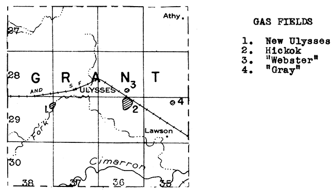
At least four deposits of volcanic ash occur in the southeast corner of Grant County in T. 30 S., R. 35 W. The nearest town and shipping point for this ash is Satanta, which lies a few miles east in Haskell County. One deposit in the NW of sec. 24 was first exploited a number of years ago, when it was connected with the Santa Fe Railroad by a narrow gage spur running north from what is known as Spar Siding. This ash is of very fine quality. Grant County was an important producer of volcanic ash during 1935.
The entire surface of Grant County is covered with formations of Tertiary age, in the more pervious parts of which ground water occurs. In many parts of the county this water lies at shallow depths.
Sand and gravel occur in potentially commercial deposits in Grant County, especially in the southern part along Cimarron River.
With the exception of the alluvium of Arkansas River, which crosses northern Gray County from west to east, and a belt of sand dunes south of the river, practically all of Gray County is covered with rocks of Tertiary age. A small amount of stone was quarried from the Tertiary in Gray County during 1935 and used as rubble.
Water is available in the flood plain of Arkansas River at shallow depths. Communities in southern Gray County obtain water from deeper wells drilled into the Tertiary rocks.
No deep tests for oil or gas have been drilled as yet in Gray County. It lies midway between the Morrison oil and gas field of Clark County and the Shallow Water oil field of Scott County. Gray County is in what is known as the Dodge City basin, and consequently the Ordovician formations are deeply buried. The eastern edge of the southwestern Kansas gas field has not yet been outlined by dry holes. At the present time the nearest gas well is in southwestern Haskell County, about 18 miles from the southwestern corner of Gray County.
A series of sand and gravel deposits occurs along Arkansas River in north central Gray County. Additional deposits are found to the north Where local streams have reworked the Tertiary sediments.
The entire surface of Greeley County is veneered with the Ogallala formation of Tertiary age, although Upper Cretaceous formations occur in Colorado adjacent to the western boundary. Water is obtained in the alluvium of White Woman Creek, which crosses central Greeley from west to east, at shallow depth, and in the Ogallala at depths as nuch as 200 feet. In a few places in the county the Tertiary is too thin to be water bearing. Two wells have been drilled to the Dakota, which lies at a depth of about 1100 feet, and have encountered good water.
Greeley County has not yet been tested for oil and gas. The nearest production is the Shallow Water field in Scott County, two counties to the eastward.
Sand and gravel deposits occur in the vicinity of Tribune in central Greeley County, where local streams have reworked the Tertiary sediments.
Greenwood is the outstanding county in Kansas for "shoestring" sand production. The northern half of the county is crisscrossed by these exceptionally elongate oil pools. Production is obtained from the Bartlesville horizon in the lower part of the Cherokee shale formation at depths of 2,000 to 2,500 feet. The "Mississippi lime" is also productive in Greenwood County, especially in the northeastern and south-central parts. A few pools produce from Lower Pennsylvanian horizons other than the Bartlesville.
The first important oil well in Greenwood County, drilled in 1921, led to the discovery of the Sallyards pool, which was eventually found to be an important link in the "Golden Lane" that extends from eastern Butler County northeastward across northern Greenwood County. New discoveries followed rapidly and by 1926 Greenwood was the leading oil-producing county of the state, with a production slightly in excess of 17,000,000 barrels. During 1936 the production for this county (along with that of Woodson County) totaled 4,001,076 barrels. The largest field was the Virgil-North Virgil.
An extensive repressuring project is being carried on in the Madison field.
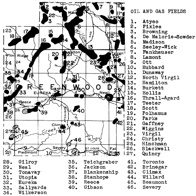
Four plants produce gasoline from natural gas from from the Madison, Seeley , Teeter, and Thrall fields at Madison, Hamilton, (two plants) and Kembro. The Kembro plant and one Madison plant use the compression process. The other plants produce natural gasoline by absorption.
The Flint Hills cross Greenwood County from north, to south. A succession of massive limestone beds outcrop across the county for its entire length and are well exposed in many places. Limestone was quarried and crushed for use as road metal and in concrete aggregate in Greenwood County during 1935.
Greenwood County is drained by the Verdigris River and its tributaries. Municipal and industrial supplies of water are obtained mainly from the surface waters or from shallow wells into the relatively narrow flood plains which occur in this part of the state. Ground water also occurs in fractures in some of the limestone formations, but this water is mineralized where tapped at any great distance from the outcrop.
Central Hamilton County is crossed from west to east by the Arkansas River. Sand and gravel deposits are common along this stream, and a small amount of gravel was produced for structural purposes during 1935.
Abundant water is available across central Hamilton County by means of shallow wells into the Arkansas River flood plain. The Tertiary rocks north of the river furnish local supplies of water. Some wells obtain water from the Codell sandstone. Artesian water was struck at Coolidge on Arkansas River near the Colorado line by a well drilled to the Dakota sandstone. South of the river the Dakota lies at moderate depths, and is the main aquifer in that area. It yields abundant water of excellent quality.
An oil test was drilled to a depth of 5,488 feet in sec. 5, T. 26 S., R. 41 W. in 1923. This well was the deepest well in the state at the time of its completion. No oil or gas were found. At the present time a well is drilling about 2 miles away in sec. 30, T. 25 S., R. 41 W. The structure on which this well is being drilled has been mapped and checked by core drill and seismograph. It is planned to carry the well into Ordovician sediments which were not tested by the older well. The southeastern part of Hamilton County was being actively leased in 1936.
Several exposures of volcanic ash have been found in Hamilton County. The largest one of these is in sec. 13, T. 26 S., R. 41 W. It is doubtful if the ash deposits in Hamilton County have commercial possibilities at the present time due to the compact nature of the ash, the small size of the deposits, and their relative inaccessibility.
Building stone has been quarried in Hamilton County in the past to supply local needs. Dakota sandstone has been quarried in the southwestern part of the county, Greenhorn limestone north of the towns of Kendall, Syracuse, and Coolidge, and Fort Hays limestone along Bridge Creek northeast of Coolidge.
The bed-rock formations of Harper County consist mainly of red sandstones and shales with a few thin gypsum beds. What water does occur in the bed-rock is highly mineralized. Fortunately, the Permian formations are veneered in many places in the county by younger rocks in which potable water occurs. The northwestern part of the county is covered by Tertiary rocks which carry water in the more permeable layers. To the south and east, much of the county is mantled with Quaternary terrace deposits, remnants of older flood plains. Gravel-filled channels occur in these terrace deposits, in which water, sufficient for local needs, is available at relatively shallow depths.
Much of Harper County is leased for oil and gas. Leasing was especially active in the northwestern and southeastern parts of the county during 1936. Harper is surrounded by producing counties, but attempts to obtain oil or gas have so far been unsuccessful. Three deep tests have been drilled during the last 3 years, and shows of oil have been reported. The location and depths of these wells follow:
| Location | Date | Total Depth |
|---|---|---|
| Sec. 17, T. 31 S., R. 9 W. | September, 1934 | 4816 |
| Sec. 17, T. 33 S., R. 6 W. | September, 1935 | 5078 |
| Sec. 17, T. 35 S., R. 8 W. | August, 1936 | 6004 |
A fourth test in sec. 4, T. 34 S., R. 8 W., is now drilling below 5202 feet.
For many years a plant at Anthony obtained salt from brine wells. The company recently went out of business.
Two deposits of volcanic ash occur about 2 miles east of Anthony. One of these deposits was worked in 1927 and the greater part of the ash removed.
Sand and gravel deposits are common along Bluff Creek and its tributaries. Some of these are terrace deposits.
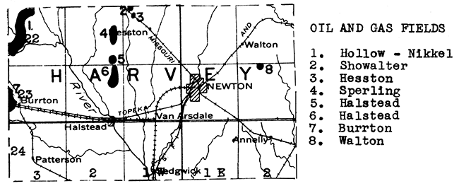
The first commercial oil pool of Harvey County, the Walton, was discovered in December, 1923. This pool lies near the eastern boundary of the county and produces from formations in the Kansas City-Lansing groups. The next major discovery in the county was 8 years later, when the discovery well of the Hollow-Nikkel field was completed. l~is field lies in the no~thwestern corner of the county and extends northward into southern McPherson County. Some very large oil and gas wells have been completed during the drilling of this field. Production is now being obtained from four horizons, the Kansas City-Lansing, the "Mississippi lime", the Hunton formation, and the "Wilcox" sand. The most prolific source of oil and gas is the Hunton, which is reached at depths in the neighborhood of 3,500 feet. Other Hunton lime and Mississippi lime" pools occur in the central and northern parts of the county.
Production in Harvey County rose from 5,400 barrels in 1931 to a peak of 3,425,895 barrels in 1934. The production for 1936 was 1,592,304 barrels. Most of this came from the Hollow-Nikkel pool.
All of Harvey County except the eastern end is floored with river alluvium deposited either by the Arkansas River or by an ancient stream that one time entered the Arkansas River from the north. Large quantities of water are stored in both the older ("Equus beds") and modern river deposits. The city of Newton lies just east of the Equus-bed area, but obtains its water from wells a few miles westward drilled into this very important water-bearing formation. The eastern end of Harvey County is underlain by bed-rock formations of Permian age which carry mineralized water.
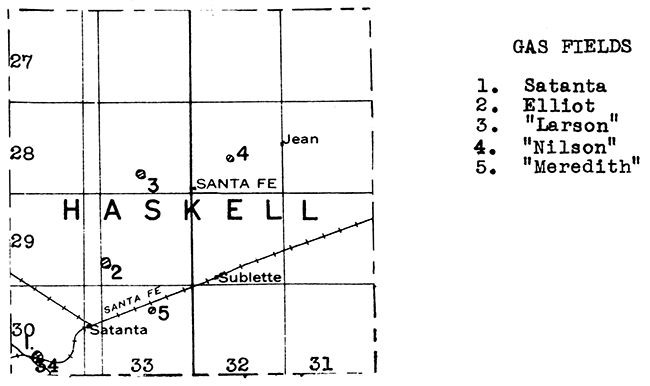
Haskell County contains five isolated gas wells as follows:
| Location | Depth | Production |
|---|---|---|
| Sec. 28, T. 28 S., R. 33 W. | 2,771 ft. | 3,000,000 cu. ft. |
| Sec. 21, T. 28 S., R. 32 W. | 2,745 ft. | 2 ,000,000 cu. ft. |
| Sec. 30, T. 29 S., R. 33 W. | 2,747 ft. | 2,400,000 cu. ft. |
| Sec. 29, T. 30 S., R. 34 W. | 2,640 ft. | 13,600,000 cu. ft. |
| Sec. 10, T. 30 S., R. 33 W. | 2,650 ft. | 500,000 cu. ft. |
In all probability, all of these gas wells belong in one great gas field that extends northeastward from the Hugoton area. Producing gas wells occur to the northward in southwestern and western Finney County. The eastern limit of the gas field is not known. During 1936 leasing was active in western Haskell County.
Haskell County is floored with Tertiary rocks, in the more porous parts of which usable ground water occurs. Shallow wells and wells of moderate depth produce a sufficient quantity of water for local and municipal use.
One deposit of volcanic ash of unknown extent his been reported from the southwestern corner of Haskell County.
Sand and gravel deposits occur in southwestern Haskell County along Cimarron River, and near the northwestern corner of the county.
The uplands of Hodgeman County are covered with the Ogallala formation of Tertiary age. The valleys of Sawlog and Buckner creeks and Pawnee River cut through the Tertiary rocks and expose the underlying Cretaceous formations. Ground water is available in Hodgeman County from the stream alluvium, the Ogallala formation, and the much deeper Dakota sandstone. The municipal water supply of Jetmore comes from drilled wells about 50 feet deep into the stream alluvium of Buckner Creek. Individual wells from the same source supply the inhabitants of Hanston, farther down the creek. The Ogallala formation yields sheet water practically everywhere in Hodgeman County, except around the margins where drainage has taken place, at depths not exceeding 100 feet. As a general rule, the alluvium and Tertiary wells produce hard water due to the high calcium-carbonate content of the enclosing rock.
In the southern part of Hodgeman County, along the eastern edge of T. 24 S., R. 23 W., wells obtain artesian water near the top of the Dakota at a depth of about 200 feet. The Dakota water is softer than that from the younger formations in most instances.
Central Hodgeman County is crossed from south to north by the Bazine anticline. Three oil tests have been drilled on this anticline. The northernmost one of these wells, in sec. 19, T. 21 S., R. 22 W., obtained small shows of oil and gas, and was abandoned at a total depth of 4,391 feet in the lower part of the Pennsylvanian series. A second well was drilled in sec. 30, T. 22 S., R. 23 W. to a depth of 5,120 feet. It penetrated the Ordovician rocks, but did not encounter any shows of oil or gas. A well in sec. 22, T. 24 S., R. 23 W., in the southern part of the county, was drilled to a depth of 4,080 feet, but did not go deep enough to test the "Oswald lime". Because only one well has reached the Ordovician rocks, Hodgeman County cannot be considered to have been adequately tested for oil and gas.
The sand and gravel deposits of Hodgeman County are largely unexploited. Beds of unconsolidated sand and gravel occur along the slopes south of Pawnee River in the western half of the county. Other deposits occur in the stream alluvium along Buckner Creek.
In past years many thousands of stone fence posts have been quarried from the "fence post" limestone and lower limestone beds in the Greenhorn formation. Some of this rock has also been used in the construction of residences and buildings.
A series of thick and persistent limestones crosses Jackson County from northeast to southwest. Among these limestones are the Howard, Burlingame, Emporia, Tarkio, Americus, Neva, and Cottonwood formations. In many parts of the county the bed-rock is obscured by a thick mantle of glacial drift. Two operators reported production during 1935 of limestone in Jackson County for use as road metal and in concrete.
Jackson County is drained by southward-flowing tributaries of Kansas River, in the valleys of which flood-plain deposits yield local water supplies. Water is available in many places in the uplands from glacial drift, and in some instances from bed-rock formations. However, wells drilled into bed-rock at some distance from the outcrop may strike mineralized water.
Three shallow tests have been drilled in Jackson County, none of which reached the "Mississippi lime", and two deep tests which reached Siluro-Devonian rocks. One of the latter was in sec. 3, T. 8 S., E. 14 E. The other was drilled in sec. 27, T. 7 S., R. 15 E. The latter well was reported to have had a show of oil at the top of the Siluro-Devonian at a depth of 2,639 feet. Jackson County lies on the flank of the Forest City basin. It has not yet been adequately tested.
A fine sand of possible glacial origin, about 2 miles north of Birmingham, on State Highway 16, has been exploited to some extent.
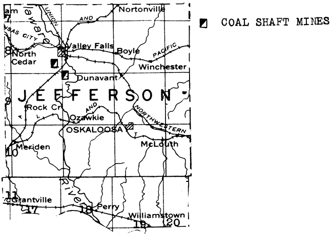
The coal at the top of the Severy shale, immediately beneath the Howard limestone, that is mined in the Osage County district is also present in western and northern Jefferson County. Two mines operated near Valley Falls during 1936, producing 630 tons of coal. One of these mines ceased operating in June.
The Kansas River, with its broad flood plain, forms the southern boundary of Jefferson County. Drainage is southward into this river. Water is available at shallow depths in the flood plains of Kansas River and its major tributaries. It is also possible in parts of Jefferson County to obtain water from wells into the glacial drift that mantles the uplands in the northeastern part of Kansas. The deeper bed-rock waters are invariably mineralized, but local supplies can be secured from fractured limestones near the outcrop.
Five wells have been drilled for oil or gas in Jefferson County. The formations encountered are described in Bulletin 20 of the State Geological Survey of Kansas. Three of these wells were abandoned while still in the Cherokee shale, a fourth well penetrated 70 feet into the St. Peter ("Wilcox") sandstone, and the fifth well went several hundred feet into pre-Cambrian rock, encountering a very thick section of "Siliceous lime" immediately above the pre-Cambrian. Several shows of oil and gas were reported in these wells. Most of the wells were drilled without regard to the presence or absence of structures favorable to the accumulation of oil and gas, and in consequence the county has not been adequately tested as yet.
The Oread, Lecompton, Deer Creek, and higher limestones cross Jefferson County from northeast to southwest. The Oread has been quarried near the southeastern corner of the county, and numerous quarry sites are present to the north in the higher limestones.
Most of Jewell County is floored with shale and chalk of Upper Cretaceous age. These formations are too tight to yield water in any quantity. Unfortunately, in this part of the state the deeper Dakota formation carries water too saline for use. Some local and municipal supplies are obtained from shallow wells dug or drilled into the narrow alluvial deposits of the small streams which drain the county. In many cases considerable testing has been necessary before a gravel bed carrying sufficient water has been encountered. Other local aquifers are the gravel bed at the base of the Sanborn loess formation, and the Codell sandstone which underlies the Niobrara formation.
The volcanic ash reserves of Jewell County are exceptionally large. A widespread group of deposits occur in the vicinity of Burr Oak, especially 2 or 3 miles to the northwest. The aggregate tonnage here is probably in excess of 100,000 tons. A single isolated deposit has been reported in southwestern Jewell County in sec. 29, T, 5 S., R. 9 W.
Central Jewell County is crossed from southwest to northeast by the Fort Hays chalk member of the Niobrara formation. So far, no market has been developed for Kansas chalk, but the problem is being studied by the State Geological Survey.
No deep oil and gas tests have been drilled in this vicinity. Jewell County lies near the center of the Salina Basin and wells will have to go to a considerable depth to reach the formations productive of oil to the south and southwest. For this reason, the oil companies have been slow to test this part of the state.
Sand and gravel occur along Republican River in the northeastern corner of Jewell County. A deposit of limestone gravel has been mapped by State Highway engineers in the western part of the county.
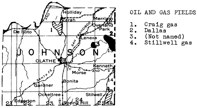
Several parts of Johnson County have produced oil and gas. The Craig gas field, in which over 60 wells have been drilled, is in T. 12 S., R. 23 E. The gas occurs in two horizons, a sand in the upper part of the Marmaton group, and a sand in the Cherokee shale about 50 feet below the Fort Scott limestone. The Dallas oil and gas field, in T. 13 S., R. 25 E., extends across the state line into Missouri. Gas occurs in an upper Marmaton sand and oil in the Bartlesville sand at a depth of about 500 feet. A smaller oil field occurs a few miles westward on the east side of T. 13 S., R. 24 E. Scattered gas wells have been drilled in the southeastern part of the county. Only two deep tests have been drilled in Johnson County. One of these, in sec. 12, T. 14 S., R. 22 E., reached the pre-Cambrian granite at 2400 feet and was abandoned at 2421 feet. The other, in sec. 4, T. 14 S., R. 24 E., was drilled 220 feet into the "Siliceous lime" to a total depth of 1,785 feet. Johnson County lies high on the flanks of the Forest City basin and should have some "Siliceous lime" tests drilled on anticlinal structures.
A series of important limestones, including the Winterset, Drum, Iola, Wyandotte, Plattsburg and Stanton formations, outcrops in Johnson County. These limestones have been exploited in northern and southwestern Johnson County for many years due to the proximity of the Kansas City metropolitan area. During 1935 limestone was quarried mainly for use in road metal and concrete, and to a lesser extent as riprap.
A large quantity of sand and gravel is dredged from the bed of Kansas River in Johnson and Wyandotte Counties. In addition, near Holliday is a deposit of glacial gravel which has been extensively exploited. Producers of sand and gravel in Johnson County in 1935 reported the production and sale of structural sand, paving sand, engine sand, structural gravel, and paving gravel.
A number of wells sufficient to supply local needs obtain-water from bed-rock formations in Johnson County. Some of the limestones, such as the Plattsburg, are sufficiently jointed or cut by solution channels to produce water when wells penetrate these openings. Even some of the shale formations in this county contain sandy beds which carry water. However, the most abundant bed-rock aquifer in Johnson County is the Stranger sandstone which covers the uplands in the western part of the county. A number of farm and municipal wells produce from this formation.
Abundant water is available in the northern part of the county from the flood plain of Kansas River. In most places this valley fill contains coarse sand or gravel layers which are filled with water. The very narrow flood plains built by the short northward-flowing tributaries of Kansas River are much less reliable as sources of ground water. Water has been found in some of these alluvial deposits, however.
Rock samples collected in the the limestone mine one-half mile west of Morris were blown into fine white rock wool in the experimental plant at the University of Kansas. An enormous quantity of raw material is available in Johnson County for rock wool manufacture.
In March, 1937, a wildcat in sec. 36. T. 26 S., R. 35 W. produced 2 1/2 million cubic feet of gas at a depth of 2815 feet. Two months later a 1 1/2 million foot gas well was completed in sec. 32, T. 25 S., R. 35 W., at a depth of 2793 feet. These wells probably lie on the northern extension of the Hugoton gas area. Gas has been found to the northeast in western Finney County and in all probability southeastern Kearny County is underlain by gas. The northern and western limits of the field in this county are entirely unknown, as no other wells have been drilled to the gas horizon , A considerable part of northwestern Kearny County has been recently leased, following seismograph surveys in that area.
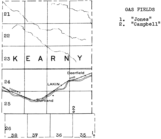
The entire surface of Kearny County is covered with Tertiary rocks, sand dunes, and the flood plain of Arkansas River, which crosses the central part of the county from west to east. Sheet water is present over most of the county at moderate depths.
Kingman County has had two discoveries. The first was on January 25, 1926, when a well drilled to a depth of 3,853 feet, in sec. 16, T. 27 S., R. 7 W., was completed with an initial production of 120 barrels a day from the top of the "Mississippi lime". A few days later this well was deepened to a depth of 3,894 feet, following which oil flowed over the top of the crown block at the rate of 804 barrels a day. The output of oil rapidly diminished and the amount of water increased, and by September of the same year the well was producing only 12 barrels of oil and 100 barrels of water per day. It was plugged in September, 1927, after having produced about 27,000 barrels of oil, all of which flowed naturally. This discovery was responsible for the drilling of some thirty wildcat tests, including direct offsets, all of which were failures.
The second Kingman County discovery was in January, 1931, when an oil well was drilled in sec. 30, T. 27 S., R. 10 W. This led to the development of the Cunningham field in western Kingman County, adjacent to the Pratt County line. Both the Kansas City "lime", at a depth of 3,400 feet, and the "Siliceous lime" at 4,125 feet are productive in this field. About 34 wells were producing in 1936, with a total production for the year of 213,381 barrels.
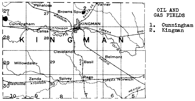
Gasoline is extracted from the gas process in a plant at Cunningham.
The valleys of Chikaskia Creek and the south fork of Ninnescah River have eroded below the veneer of Tertiary rock in parts of eastern Kingman County, exposing the underlying red beds. Usable water is available in this area only in valley fill and low terrace deposits. Water is available over most of the balance of the county from sand and gravel layers in the Tertiary rocks.
Sand and gravel occur along south fork of Ninnescah River southwest of Kingman.
The northern part of Kiowa County is covered with dune sand. Comanchean sandstones and shales, and Permian red beds are exposed in the valley of Medicine Lodge River in the southeastern corner of the county. The rest of Kiowa County is floored with the Ogallala formation of Tertiary age. Sheet water occurs at relatively moderate depths beneath most of the county, except in the southeastern corner. Domestic and municipal supplies are obtained from wells.
The discovery of oil in the Morrison field of eastern Clark County led to considerable leasing activity in western Kiowa County in 1936. However, no deep tests have as yet been drilled in this county. The next few years will no doubt see some exploratory wells drilled. Kiowa County lies between the Morrison field on the southwest and the McCarty field in Edwards County to the north. Oil and gas production is also found to the southeast in Barber County.
Sand is abundant in some parts of Kiowa County and has been produced in the past.
Labette County has produced oil for a great many years and still has an annual production of about 5,000 barrels. Most of the fields are in the western part of the county in the vicinities of Dennis and Mound Valley, and along the Montgomery County line. Southwestern Labette County was the scene of an active and successful drilling campaign for gas in 1928 and 1929. Over 100 wells were drilled to depths ranging from 150 to 700 feet. The initial production of these wells ranged' from but a few thousand cubic feet up to 3 million. Cherryvale, Parsons, and other towns in the vicinity are supplied with gas from this district.
Producing formations in Labette County include the Fort Scott limestone, sands in the Cherokee shale, (including the Bartlesville), and the top of the "Mississippi lime".
Eastern Labette County lies in the southeastern Kansas coal district. During 1936 5 strip mines between Chetopa and Oswego produced 13,703 tons of coal in this county.
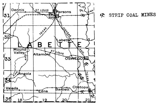
Labette County is crossed from northeast to southwest by the Fort Scott, Pawnee, Altamont, Bethany Falls, Winterset and Drum limestones. The last named is confined in its outcrop to the very northwestern corner of the county. Three operators reported limestone production from quarries in the northern part of Labette County during 1935. This stone was used in road metal and concrete.
Labette County is largely dependent upon surface water for abundant supplies. The only valley fill of any magnitude is along the eastern border of the county neighboring Neoaho River. Chetopa, near the southeastern corner of the county, has a deep well into the "Mississippi lime".
Sand and gravel deposits occur along Neosho River in northeastern Labette County.
A bed of algal limestone which occurs at the top of the Tertiary rocks in parts of Lane County has been quarried to some extent for road material.
Lane County is covered with the Ogallala formation of Tertiary age except along the northern edge and in the stream valleys in the eastern part of the county, where the Niobrara formation of Upper Cretaceous age is exposed. Sheet water is present at a relatively shallow depth throughout most of the Ogallala area, except around the edges where drainage has taken place.
One deep test has been drilled in Lane County, about 2 miles south of the Gove County line in sec. 16, T. 16 S., R. 28 W. It encountered a show of oil in Lansing "lime" between 4,050 and 4.055 feet. The we LL was abandoned at 5151 feet, total depth.
Sand and gravel deposits have been found in various parts of Lane County where local streams have reworked the Tertiary sediments.
Leavenworth County has one producing gas field at the present time. This field lies north and northeast of Linwood for a distance of about 4 miles. Most of the gas comes from the "Squirrel sand" in the upper part of the Cherokee shale at a depth of about 700 feet. A lesser amount of gas is obtained from the Peru sand in the upper part of the Marmaton group.
Leavenworth County at one time had another gas field, the Six Corners, in the southwestern corner of the county, This field was practically exhausted by 1927, at which time it was purchased by the Empire Oil and Refining Company for use in underground gas storage.
Two wells have been completed below the Mississippian in this county. One of these was drilled in 1887 at Leavenworth, and penetrated 246 feet of "Siliceous lime", with a total depth of 2,116 feet. The other well, drilled in 1930, was located in the Linwood district, in sec. 18, T. 12 S., R. 22 E. It went 101 feet into Ordovician limestone, and was abandoned at a total depth of 1,546 feet.
A prospect hole, drilled in the hope of picking up the coal beds which outcrop to the east in northwestern Missouri, was commenced at Leavenworth in 1860 and in 1865 encountered a bed 2 feet in thickness at a depth of 713 feet. A shaft was sunk to the seam in 1870, exploitation began, and has been carried on intermittently ever since. During 1936, 3 deep mines were in operation in Leavenworth County, with a total yield for the year of 111,509 tons. A fourth deep mine, at Leavenworth, operated in 1935, but not in 1936. One mine is operated by the Kansas State Penitentiary at Lansing.
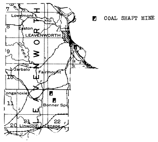
The Plattsburg-Stanton limestones are well exposed in the bluffs of Missouri River on the east side of Leavenworth County. The uplands farther to the west and southwest are capped by the Oread limestone. Both of these limestone groupB have been exploited in northeastern Leavenworth County, and additional quarry sites occur in the southwestern part of the county. In 1935 three operators reported limestone production. The U.S. Army Engineering Department, one of the three operators, used stone for riprap. The balance of the stone quarried was used in road metal and concrete.
Sand and gravel were dredged from the stream bed of Missouri River by one operator during 1935. This material was used for structural purposes.
Abundant supplies of water are available in eastern Leavenworth County from the Missouri River and from shallow wells into the valley fill of this stream. Water is also available in the central part of the county from the coarse layers in the fill of Big Stranger Creek. The water-filled flood plain of the Kansas River runs along the southern boundary of the county. Water is much more difficult to obtain in the upland parts of the county. Some good wells have been dug or drilled into the Stranger sandstone, which outcrops in the eastern part of the county. In a few localities deposits of glacial gravel contain sufficient ground water to supply local needs.
The largest sandstone producer in Kansas is the Quartzite Stone Company, with a quarry a short distance southeast of Lincoln Center. Tbe stone is not a true quartzite, but is a sandstone which is so tightly cemented by calcium carbonate that it has the appearance of quartzite. This stone is a local phase in the Dakota formation. The sandstone produced from the quartzite atone quarry during 1935 was used in concrete and to a relatively minor extent as filter stone. "Fencepost" limestone quarries are numerous in the northern and southwestern parts of Lincoln County.
Local and municipal supplies of water are available in the belt of Dakota outcrop by means of wells dug or drilled into the sandy layers of that formation. In the upland areas, where the younger Cretaceous formations overlie the Dakota sandstone, deep wells have found salt water in some of the sandy layers. It has been possible, however, in some instances, to case off higher salty aquifers and to penetrate lower potable water sands.
A deposit of volcanic ash has been reported in sec. 27, T. 13 S., R. 10 W., in the southwest corner of Lincoln County. This may be the deposit where the volcanic ash being shipped from Wilson, in northwestern Ellsworth County, is obtained.
About fifteen tests for oil and gas have been drilled in Lincoln County during the last 20 years. However, most of these were located on pronounced domes in the outcropping Cretaceous rocks, and subsequent investigation has shown that these domes are due to initial dip over buried Permian hills, and consequently they do not continue downward into the formations that are potentially oil-bearing. Because no deep tests have been drilled on favorable subsurface structures, the county may be considered to be untested.
Limestone gravel is abundant in western and southern Lincoln County. Investigations recently conducted by the Kansas Geological Survey have shown that satisfactory rock wool can be blown from a mixture of Dakota "quartzite" and Greenhorn limestone.
Linn County lies in the shallow oil and gas district of eastern Kansas. It has had a relatively small production for many years. During the last 10 years production has decreased from 89,208 barrels in 1926 to 38,969 barrels in 1935. The principal oil field is the Parker-Goodrich "string" in the northwestern part of the county. This field is a continuation of the Bush City "shoestring sand" oil field of Anderson County. An old gas field, the Blue Mound, was extensively drilled during 1927 and 1928. This field lies in the northeastern part of T. 22 S., R. 22 E., and the western part of T. 22 S., R. 23 E. The gas sand lies in the lower part of the Cherokee shale at depths of 650 to 700 feet. Production varies from a quarter of a million to over 4 million cubic feet. Another gas field was opened in 1929 along the Linn-Anderson county line in T. 21 S., R. 21 E. Scattered small fields occur in the vicinities of Centerville, Mound City, Pleasanton, and LaCygne.
All of the production so far discovered in Linn County comes from sands in the lower part of the Pennsylvanian. The formations below the "Mississippi lime" have not been adequately tested. Linn County lies high on the north flank of the Chautauqua arch, and tests located on well-defined anticlines should be drilled to the "Siliceous lime".
The only rock asphalt production in Kansas comes from Linn County. One plant located at Pleasanton reported production during 1915. According to an unpublished report by Dr. John W. Ockerman on file in the office of the Kansas Geological Survey, an asphalt-bearing sandstone, known as the Bourbon, crosses Linn County from the northeastern corner to the center of the south boundary. The higher Swope limestone, which crosses central and western Linn County from north to south, is likewise asphalt-bearing in places. Quarries are located in asphaltic sandstone a short distance northwest of Pleasanton, and in asphaltic limestone about 2 miles north, and 3 1/2 miles southwest, of LaCygne.
Coal has been mined intermittently in Linn County for many years. During the last few years a marked increase in mining has taken place in this district, and in 1936 15 deep and 3 strip mines were in operation in the county, producing a total of 36,636 tons. The coal occurs in the Bandera shale in the Marmaton group. It is mined in the vicinities of Prescott, Pleasanton, Boicourt, LaCygne, and Blue Mound.
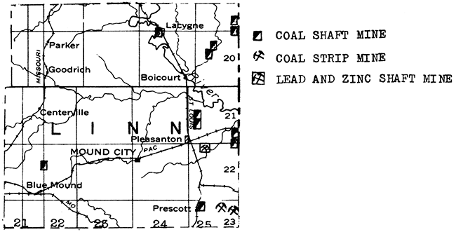
One shaft mine located two miles southwest of Pleasanton exploits a local deposit of zinc and lead ore.
The limestones exposed in Linn County range from the Fort Scott to the Plattsburg. The very important Altamont, Bethany Falls, Winterset, Drum, and Iola formations are present in this series. The County Commissioners reported production of limestone used in road metal and concrete during 1935. One quarry is near the northeast corner of the county. Sandstone has also been quarried in this county, but no production was reported during 1935.
The Marais de Cygnes River cuts across the northeastern part of Linn County, with a flood plain averaging from 1 to 2 miles in width. Sand and gravel are present in the flood plain and in the bed of the stream. A relatively large tonnage of paving gravel was reported by a Linn County producer in 1935.
LaCygne obtains its water supply from Shallow wells into the alluvium of Marais de Cygnes River. For municipal and industrial supplies elsewhere than in the northeastern part of the county, crossed by the Marais de Cygnes River, it has been necessary to use surface water. Local supplies of water can be obtained in many parts of the county from chert gravels in the narrow flood plains of the tributary streams, and from fractured limestone formations near the outcrop.
Only northern, northeastern, and southwestern Logan County is capped by the Tertiary Ogallala formation. The Smoky Hill River has eroded below the Tertiary capping in the rest of the county, exposing the underlying Upper Cretaceous Pierre shale and Niobrara Chalk. The Tertiary-Cretaceous contact contains many springs, due to the escape of sheet water from the Ogallala formation. For that reason, the Ogallala is not water-bearing in many instances close to the edge of its outcrop. A few springs and local wells obtain water from fractures in the Pierre shale. Another source of water is the flood plain of Smoky Hill River, which crosses the county from west to east. Small amounts of water are also available in the narrow alluvial deposits of the tributary streams. Deep wells drilled to the Dakota formation in the southern part of the county have encountered brackish water which was unfit even for stock use.
During the fall of 1935 a deep test was drilled in southeastern Logan County in sec. 13,T. 15 S., R. 33 W. This well encountered "Siliceous lime" at 5,260 feet, granite wash at 5,660 feet, and was abandoned as a dry hole in the granite at 5,756 feet. A second deep test was started in the county in October, 1936, in sec. 12, T. 15 S., R. 35 W. This well encountered difficulties and was abandoned at 3,909 feet. Subsequently the rig was skidded and a new hole started. Most of Logan County has been mapped by seismograph surveys, and leasing was very active in the southwestern part during 1936. With the exception of the southeastern corner, Logan County has not been adequately tested for oil and gas.
There are at least two deposits of volcanic ash in Logan County. One of these is about 1 1/2 miles north of the Smoky Hill River in the southern part of T. 14 S., R. 33 W. The ash bed is from 5 to 6 feet thick and its outcrop can be traced about 250 feet. Another deposit is in the northeast corner of sec. 11, T. 13 S., R. 35 W. This ash bed is about 9 feet thick with an overburden of 10 feet. Another outcropping occurs a few yards to the south and across the valley.
Logan County abounds with sand and gravel deposits, especially the north central and southeastern parts.
A low-gravity oil pool, the Bradfield, was discovered near the southeastern corner of T. 21 S., R. 10 E., in 1922. Some wells had an initial production as high as 1,000 barrels a day. The oil was produced from an Ordovician sand at depths of 2,200 to 2,500 feet. The production from this field in 1925 was 27,515 barrels. Production jumped in 1926 to 625,931 barrels, due to the extension of Bartlesville "shoestring sand" pools northward from Greenwood County into southern Lyon County. The county production reacted a peak in 1927, with a yield of 715,131 barrels. A decline followed, and the yield in 1935 was but 80,718 barrels. However, the following year, production rose to 138,830 barrels.
The principal fields in Lyon County, both of then extensions from Greenwood County, are the Ateyo, in the very southwestern corner of the county, and the Fankhouser, in the southern part of T. 21 S., R. 12 E.
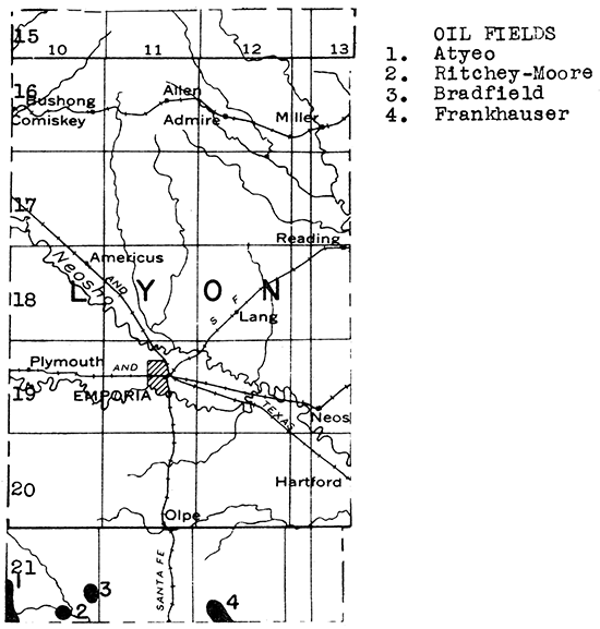
A series of limestones, ranging from the Topeka to the Wreford, crosses Lyon County from northeast to southwest, Among these formations are the Howard, Burlingame, Emporia, Americus and Cottonwood limestones. The Tarkio and Emporia limestones outcrop in the vicinity of Emporia. Three producers reported quarrying limestone during 1935. Most of this stone was used in road metal and concrete, but some was also used for rough construction and rubble. One quarry is a short distance southwest of Emporia. Additional quarry sites occur in northeastern and south central Lyon County.
The main supply of water in Lyon County comes from the flood plains of the Cottonwood and Neosho rivers, which join a few miles east of Emporia, or from the streams themselves. Local supplies of water can be obtained in some parts of the county from the chert gravels in the tributary valley fills and from fractured bed-rock limestone. However, during times of drought these sources of water supply may fail. The deeper bedrock waters are invariably mineralized.
The discovery of oil in the Elbing pool in northwestern Butler County in 1919 led to the discovery soon afterwards of the Peabody pool in southern Marion County. During the next few years the Covert-Sellers and the Florence-Urschel pools to the north and northeast were likewise discovered and developed. The oil occurs in Ordovician rocks at an average depth of about 2,400 feet.
Three pools were subsequently discovered in central and northern Marion County. One of these, the Propp gas field, was discovered with a 4,000,000 foot gas well in April, 1926. The wells in this pool produce from the "Chat" horizon in the "Mississippi lime". The Lost Springs oil pool, in the northeastern corner of the county, was discovered by a well drilled in November, 1926. This pool produces oil from the Mississippian "chat". About 9 miles to the west of the Propp gas field, the discovery oil well of the Hillsboro field was completed in October, 1928. This well first produced from the "Mississippi lime", but as subsequent wells in the field obtained better production from the Viola, the discovery well was later deepened to the Ordovician rocks.
Marion County reached a production peak about 15 years ago when the Ordovician fields in the southern part of the county were at flush production. Subsequently production has declined to 410,476 barrels (1936).
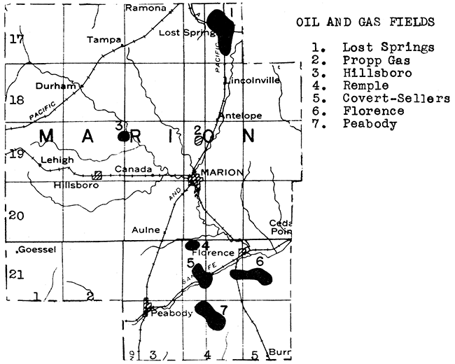
Eastern Marion County is crossed from north to south by the Florence flint, Fort Riley, Winfield, and Herington limestones. The Fort Riley has been extensively quarried in the vicinity of Florence. Higher limestones are available for quarrying southwest of Marion. The county produced a considerable tonage of crushed limestone during 1935 for use as road metal and in concrete.
The city of Marion uses surface water for its supply; while Hillsboro, Peabody, and Florence obtain water from shallow wells. Cottonwood River runs across eastern Marion County. Water is present in the alluvium of this stream, and in the valley fills of some of its tributaries. However, the tributary flood plains are very narrow and the amount of water stored in them is limited. Wells drilled into the Florence flint obtain water from crevices in some parts of the county.
Gypsum is mined by the Certain-teed Products Corporation south of Blue Rapids in Marshall County. The greater part of the gypsum mined is calcined before being sold. This gypsum occurs near the upper part of the Big Blue series of Permian age, and is stratigraphically lower and older than the gypsum in the red Beds of Barber County.
Marshall County is crossed from north to south by a series of limestones, including the Americus, Neva, Cottonwood, Wreford, and Fort Riley. Quarry sites occur near Marysville and Blue Rapids. Two operators reported production of limestone during 1935. The stone was used for road metal and concrete.
Marshall County is one of the most important sand and gravel districts in the state. Several large deposits occur near Blue Rapids, and other deposits are exploited near Frankfort and Marysville. The sediments were originally deposited by rivers draining the great continental ice-sheet in Pleistocene time. Some of this material has subsequently been reworked and redeposited by more recent streams. The chief product of the Marshall County deposits during 1935 was paving gravel. Structural gravel ranked second. Other but relatively insignificant products were structural sand and engine sand.
For the larger supplies of water Marshall County is dependent upon surface waters, and shallow ground water occurring in the flood-plains of the Big Blue and Little Blue rivers and Vermillion Creek. Local water supplies are obtained in the upland areas by wells into the mantle rock. Some of the limestones carry usable water in fractures near the outcrop, but deep bed-rock water is invariably mineralized.
The first successful well drilled in McPherson County was a gas well, completed in September, 1926. This well was drilled in sec. 29, T. 18 S., R. 2 W., to a depth of 2,927 feet. It had an initial yield of 7 1/2 million cubic feet of gas from just below the top of the "Mississippi lime". This discovery led to the development of the McPherson gas field, which was the largest gas field in Kansas at one time. Nearly two years later, on July 7, 1928, the first oil well in McPherson County was completed in the McPherson field, in sec. 31, T. 18 S., R. 2 W. Subsequently seven more oil and gas fields were discovered in this county, in addition to the Hollow-Nikkel field which extends northward from Harvey County into southern McPherson County. The production for McPherson County during 1936 was 4,464,439 barrels. Over half of this came from the Ritz-Canton field.
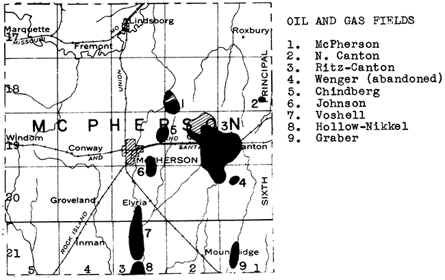
Pertinent data in regard to the oil and gas fields of McPherson County are tabulated below. The location of the fields is given on the accompanying map.
| Name of pool | Date of discovery | Producing formation | Average depth (feet) |
|---|---|---|---|
| Chindberg | Oct. 1929 (gas) | Mississippian "chat" | 3,010 |
| Dec. 1933 (oil) | Kansas City, "lime" | 2,360 | |
| Graber | May, 1934 | Hunton "lime" | 3,330 |
| Johnson | Feb., 1932 | Mississippian "chat" | 3,000 |
| McPherson | Sept., 1926 (gas) | Kansas City "lime" | 2,350 |
| July, 1928 (oil) | Mississippian "chat" | 2,950 | |
| Ritz-Canton | Jan., 1929 | Mississippian "chat" | 2,950 |
| Viola "lime" | 3,410 | ||
| "Wilcox sand" | 3,450 | ||
| Voshell | Aug., 1929 | Mississippian "chat" | 3,100 |
| Viola "lime" | 3,330 | ||
| Wilcox "sand" | 3,360 | ||
| "Siliceous lime" | 3,400 |
The Ritz-Canton field covers 17,330 acres. It was originally four fields, the Ritz, Canton, Galva, and Decker, which were connected together by the drilling of intermediate wells. A one-well "chat" pool, lying northeast of the Ritz-Canton pool and discovered in 1936, has been named the North Canton.
Two plants located in the city of McPherson obtain gasoline from natural gas by the absorption process.
Sandstone cemented with calcium carbonate similar to the "quartzite" of Lincoln County occurs in northeastern McPherson County. One operator reported sandstone production for use as road metal in 1935.
All except the eastern, northern and western edges of McPherson County is floored by an ancient river deposit known as the McPherson formation, or Equus beds. The channels of this ancient river are filled with sand and gravel. A deposit of this type was worked during 1935 by one operator in McPherson County. Structural sand, paving sand, and paving gravel were marketed.
The Equus beds contain one of the best ground water supplies in the state of Kansas. Abundant water is available over most of the Equus bed area at depths ranging from 80 to 200 feet. Ample water is present for both municipal and industrial use.
Clay has been mined in the northern part of the county and made into brick at Lindsborg. This plant has not been in operation for about five years. Clay beds from which brick and other clay products can be made have been investigated in the vicinity of McPherson.
North-central McPherson County contains a number of deposits of volcanic ash. Most of these are in the vicinity of Johnstown, between McPherson and Lindsborg. A few tons have been shipped from one of these deposits.
Satisfactory rock wool has been blown from rock specimens collected in McPherson County, near the city of McPherson.
Meade County is the leading volcanic ash producing county of Kansas, with a yield in 1935 greater than all of the other counties combined. At least twelve separate deposits occur in this county. The largest are in the northern part about 7 1/2 miles west of Fowler. A spur connects the Cudahy deposit with the Rock Island Railroad at Fowler. Other large deposits lie west and south of Meade. Four operators reported volcanic ash production in Meade County during 1935. The largest of these is the Cudahy Packing Company, which makes Old Dutch Cleanser from volcanic ash.
Meade County is covered with Tertiary rocks, except in the river valleys in the eastern and southeastern parts of the county. Throughout the greater part of the Tertiary-covered area, sheet water is available at moderate depth. The city of Meade lies in a local artesian basin. Water entering the Tertiary rocks around the rim of this basin obtains sufficient head to flow from wells drilled near the central part of the basin. An abundant supply of water is available.
Only one deep test for oil or gas has been put down in Meade County. This well was drilled in sec. 9, T. 33 S., R. 28 W., in 1928, and was abandoned at a depth of 4,650 feet. Meade County lies in the deeper part of the Dodge City basin, and tests drilled to the Ordovician must go to a considerable depth. The Morrison gas and oil field lies east of Meade County in eastern Clark County and to the west, in western Seward County, are two gas fields which are a part of the great southwestern Kansas gas district.
Sand and gravel, deposits, formed through the reworking of Tertiary sediments by recent streams, are abundant throughout most of Meade County. These have not been exploited to any extent as yet.
The first prospecting for oil or gas in Kansas took place near Paola, in Miami County, in 1860. Also Paola was the first city in Kansas to be supplied with natural gas, which was piped from a field 7 miles to the north in 1884. Miami County has been a relatively small producer of oil and gas for a great many years. Until ten years ago the leading districts were in the western half of the county, in which occur the Paola and Rantoul fields. The individual wells in this district have initial productions of less than 100 barrels a day, in most instances, and soon decline to but a few barrels.
A new discovery was made in Miami County in November, 1926, which caused an increase in the county's production from 13,153 barrels in 1925 to 752,102 barrels in 1927. The discovery well of this field was drilled in sec. 20, T. 16 S., R. 24 E. Subsequent drilling showed the producing formation to be a shoestring sand with a northeast-southwest trend, curving from sec. 14 to sec. 29, all in T. 16 S., R. 24 E. The wells vary in depth from 325 to 400 feet, and had initial productions ranging from 20 barrels to over 250 barrels. The producing sand lies within the Marmaton group. The Big Lake pool has made a remarkable return to the operators in respect to the original invested capital. In less than a week's time some wells were drilled connected to the pipe line, and all costs paid from the first production.
Repressuring operations were started several years ago in this field, after production had declined considerably. It was noted that within a week after repressuring commenced most wells were capable of producing double their former capacity.
The Big Lake discovery led to considerable drilling in the eastern half of Miami County with the result that a few additional, but much smaller, fields were discovered.
The oil and gas wells in Miami County produce from sands in the Marmaton group and in the underlying Cherokee formation. In addition "shale gas" is obtained from wells drilled into the Fort Scott at depths of 150 to 550 feet. These wells yield up to one-half million cubic feet daily.
A few wells have been drilled in Miami County into the Mississippian and older formations, but without success as yet. However, before the possibilities of deeper production are condemned in this county, additional tests located on well-defined subsurface anticlines should be drilled to the "Siliceous lime". Miami County lies between the Forest City basin and the Chautauqua arch, and from a regional standpoint is well situated in regard to oil accumulation.
The production peak for Miami County was reached in 1927. Subsequently the yield has declined, and in 1925 was 205,472 barrels.
Important limestones outcropping in Miami County include the Bethany Falls, Winterset, Drum, Iola, Wyandotte, Plattsburg, and Stanton. An enormous reserve of stone is available. Two operators reported a small production of crushed limestone for use in road metal and concrete during 1935. Many quarry sites can be found in Miami County, especially in the central and western parts.
Clay has been quarried at Paola and used in the manufacture of bricks, but the plant is not operating at present. The reserves in red-burning brick clay in Miami County are large.
Miami County is dependent upon surface waters for municipal and industrial supplies. The deeper bed-rock formations invariably carry mineralized water. Local supplies can be obtained from gravel beds in the relatively narrow valley fills, and from creviced limestones near the outcrop.
Mitchell County is crossed from west to east by Solomon-River. The river itself and the underflow in its wide flood plain furnish water to a number of towns and farms. The only bed-rock aquifer in the county with any great volume of water is the Dakota sandstone, and it carries mineralized water in central and western Mitchell County. Local supplies of water in the upland areas are obtained mainly from narrow alluvial deposits in the tributary valleys.
Great Spirit (Waconda) spring is an artesian spring near Cawker City from which flows highly mineralized water. It is exploited by a health resort and by bottling and shipping the mineral water.
A number of tests have been drilled for oil and gas in Mitchell County, but, as in the case of Lincoln County, most of these tests were located on prominent domes in the Cretaceous rocks which do not carry below into the Permian and underlying formations. Mitchell County has not been adequately tested for oil and gas in respect to the deeper subsurface structural geology. A wildcat well is now drilling in sec. 16, T. 85, R. 10 W. It was down 3011 feet at last reports.
The topmost ledge of the Greenhorn formation, known as the "fencepost" limestone or "post rock", has been quarried for many miles along the outcrop, especially north and south of Solomon River in Mitchell County. This stone has been used in fenceposts, dwellings, and buildings. The courthouse at Beloit is built of this rock.
On the north side of Solomon River Valley in eastern Mitchell County is a series of low terrace gravel deposits, which were laid down by an ancestor of the present Solomon River. Erosion by tributaries of the present river nas: 'cut this once continuous gravel deposit into a series of isolated deposits, which have been exploited for road material and structural purposes. Other terrace and flood plain deposits occur farther upriver, and accumulations of limestone and flint gravel are abundant on the uplands in the southern half of the county.
A 14 inch bed of lignite coal occurring about 30 feet below the top of the Dakota formation was mined years ago along Salt Creek and its tributaries in southern Mitchell County.
Gas has been produced in Montgomery County since 1881 and oil since 1903. Every township in the county either is producing or has produced oil or gas. The greatest concentration of fields is south and southwest of Independence, in the vicinities of Bolton, Wayside, Havana, Dearing, and Coffeyville. Another group of fields lies in the vicinity of Cherryvale, in the northeastern part of the county. Production comes mainly from sands in the lower Pennsylvanian, including especially the Bartlesville sand in the Cherokee shale. Depth to production ranges from 600 to 1,200 feet. The deeper wells are on the west side of the county, where the Bartlesville sand is lower due to regional dip to the westward. Some shale gas is found in this county in the Fort Scott formation.
Renewed interest has been shown in drilling in Montgomery County during recent years, and several new strikes have been the result. Early in 1936 a field was discovered in the NE cor. of T. 34 S., R. 15 E., a few miles northwest of Dearing. Montgomery County is thought to have possibilities of deeper production from the upper part of the "Siliceous lime". Four fields have been discovered recently in this "pay" in Chautauqua and Elk counties to the west and northwest. A "Siliceous lime" strike was reported in 1935 from northern Montgomery County.
Montgomery County reached a production peak in 1926 with 721,252 barrels. The production for 1935 was 279,902 barrels.
A series of thick limestones crosses Montgomery County from north to south. Especially prominent are the Drum and Stanton formations. A considerable tonnage of stone was quarried in Montgomery County during 1935 for use as road base, road metal, and concrete.
The Drum limestone is quarried southeast of Independence and used with alluvial clay from the nearby Verdigris River bottom in the manufacture of Portland cement. The reserves of cement rock in this county are enormous.
Clay products are manufactured from local clays at Independance, Cherryvale, and Coffeyville. Paving brick is made at Independence, bricks and retorts used in the zinc smelter at Cherryvale, and brick and tile at two plants in Coffeyville. Two glass factories are located at Caney.
The larger communities and industries of Montgomery County are dependent for water upon surface supplies. Bed-rock water is invariably mineralized where tapped at any great distance from the outcrop.
Rock wool was successfully blown from samples collected in the cement plant quarry at Independence. Montgomery County has a large quantity of rock that could be utilized in rock wool manufacture.
Sand and gravel deposits occur along Verdigris River, especially in the vicinity of Coffeyville.
Morris County contains two gas fields. One of these, the Heigle or Wilsey, was discovered in November, 1927. It lies in the north-central part of T. 16 S., R. 7 E. A few wells produce from the McKissick Grove shale at a depth of 450 feet, but the chief production comes from near the top of the Lansing group at an average depth of 1,450 feet. The second gas field is the Wilde, in the north-central part of T. 17 S., R. 7 E. This field was discovered in October, 1929, Gas comes from three horizons: (1) Willard shale at a depth of 600 feet; (2) Lawrence shale at a depth of about 1,200 feet; and (3) the Lansing group at 1,400 feet.
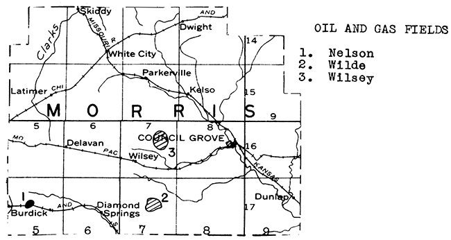
The Neosho River has its headwaters in Morris County. Its flood plain is narrow, and although rilled in part with chert gravel, does not contain an abundant supply of water during drought years. Fortunately, some of the bed-rock limestones carry water of usable quality, even at depths in excess of 100 feet. The most important of these formations is the Wreford, which underlies most of the county, and into which some good wells have been drilled. Other bed-rock aquifers are the Florence flint and the Kinney limestone. The latter is a thin limestone in the Matfield shale formation.
A few sand and gravel deposits have been found along Neosho River and its tributaries.
A number of gas wells have been drilled in eastern Morton County, which lies in the southwestern Kansas (Hugoton) gas field. The first gas well in Morton County was completed in April, 1930 with an initial production in excess of 14,000,000 cubic feet from a depth of 2,652 to 2,933 feet. Although at least two wells have drilled several hundred feet below the Permian gas-producing formations, the strata which are so productive of oil and gas farther to the east have not yet been adequately tested in this part of the state.
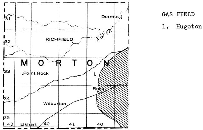
Almost all of Morton County is floored with partially consollidated continental deposits of Tertiary age. Underneath is the Dakota sandstone formation, which is also an important aquifer in this part of the state. Moderately deep wells furnish municipal and local supplies in Morton County.
Sand and gravel are abundant along Cimarron River, which crosses Morton County from southwest to northeast.
Nemaha County is covered in part with glacial drift. Beneath this drift and exposed in the larger stream valleys are limestones and shales belonging to the Wabaunsee, Admire, and Council Grove groups. Among the limestones available for quarrying are the Tarkio, Americus, Neva, and Cottonwood. During 1935 a relatively large tonnage of limestone was quarried in Nemaha County for use in road metal and concrete.
In common with other glaciated counties in northeastern Kansas, the valleys of even the smaller tributary streams are filled with alluvium in which reworked glacial gravel deposits occur. Sufficient water is available in many of these alluvial deposits to supply local and town demands. Sabetha, however, in the northeastern corner of the county, obtains its municipal supply from impounded surface water.
Two small deposits of volcanic ash occur in western Nemaha County in T. 4 S., R. 11 E. just east of the Marshall County line. The ash is only about 1 1/2 feet thick. Sand and gravel occur near Seneca, and elsewhere along Nemaha River.
Neosho County has produced oil and gas for many years. The greatest development has taken place in the northwestern quarter of the county, in the vicinity of Chanute. This is a continuation of the Humboldt district in southwestern Allen County. Other fields occur near Erie and Thayer. Most of the wells produce from sands in the Cherokee shale formation. However, a "Mississippi lime" sand gas pool was discovered 3 miles southeast of St. Paul during 1926. At about the same time shale gas was discovered in eastern Neosho County in the vicinities of Kimball and St. Paul.
There has recently been a revival of drilling activity in the Chanute area and a number of relatively small wells have been completed. The possibilities for "Siliceous lime" production in this county have not been sufficiently investigated as yet.
The oil production for Neosho County during 1935 was 177,077 barrels.
The Thayer coal bed, with a maximum thickness of 2 1/2 feet, occurs in the Chanute shale, and has been mined near Thayer in western Neosho County. During 1936, ten small shaft mines were intermittently in operation in this coal field, with a total aggregate production of 500 tons.
Various rock formations cross Neosho from northeast to southwest. The youngest and stratigraphically highest limestone in the county is the Iola, which is quarried at the cement plant near Chanute. Other limestones which cross the county are the Drum, Swope, Hertha, Lenapah, and Altamont. Two operators reported relatively small limestone production during 1935. This stone was used for road materials and, to a minor extent, as agricultural limestone.
One of the largest cement plants in the state is located at Chanute in northwestern Neosho County. This plant quarries Iola limestone and Lane-Bonner Springs shale for its cement rock. A large reserve is available.
Neosho County is crossed from the northwest to the southeast by Neosho River. The larger municipal and industrial supplies in the county are obtained from this stream. However, local supplies are available in some parts of the county from stream alluvium. The deeper bed-rock water-bearing formations carry water too highly mineralized for use.
Tests in the laboratories of the State Geologlcal Survey have shown that satisfactory rock wool can be blown from formations in Neosho County. Samples were taken at the cement plant quarry at Chanute.
Many deposits of sand and gravel of commercial value occur along Neosho River, especially in the southeastern part of the county.
Ness County has two oil wells a little over a mile apart. The first one of these wells, the Aldrich, in sec. 7, T. 18 S., R. 25 W., was completed in November, 1929. It produces from basal conglomerate at a depth of 4,225 feet. The second well, the Thompson, was completed in July, 1936. This well is in sec. 13, T. l8 S., R. 26 W. It produces from the "Siliceous lime" at a depth of 4,500 feet. These wells are not on pipe line and the oil that has been produced has been trucked from the well to a pipe line. Drilling between these wells may prove that both belong in a single pool. The Thompson well had an initial production of 684 barrels. The initial production of the Aldrich well was 128 barrels. The latter has not yet been drilled to the "Siliceous lime".
A well drilled in sec. 35, T. 18 S., R. 21 W., east or Bazine and near the Rush County line, had a 20-barrel show of oil at a depth of 4,182 feet from the basal conglomerate of the Pennsylvanian series.
Another dry hole was completed in June, 1931, in sec. 25, T. l7 S., R. 25 W. at a depth of 4807 feet. This well found the base of the Pennsylvanian at 4418 feet and the top of the "Siliceous lime" at 4709 feet. It had 500 feet of oil standing in the hole between 4374 and 4376 feet.
Recent deep tests in Ness County are given in the table below:
| Location | Date | Depth |
|---|---|---|
| Sec. 16, T. 19 S., R. 2l W. | February, 1933 | 4777 |
| Sec. 21, T. 19 S., R. 23 W. | March, 1934 | 5052 |
| Sec. 34, T. 18 S., R. 21 W. | December, 1936 | 4696 |
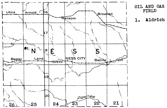
Ness County is well supplied with ground water. The uplands in the northern and western parts of the county are capped with the Ogallala formation of Tertiary age, in which sheet water occurs at depths not exceeding 100 feet. The town of Ransom has a municipal water supply from this aquifer. Individual wells in Arnold and Brownell and a great many farm wells on the uplands likewise penetrate the sheet water zone near the base of the Ogallala formation. A deeper aquifer in this county is the Dakota sandstone, which contains potable water in this part of the state. An 800-foot well furnishes the municipal supply for Utica. Ness City obtains its municipal supply from the same formation at a depth of about 450 feet. In the larger stream valleys water is obtainable in the alluvium at depths up to 50 feet.
A small deposit of volcanic ash occurs in the northwest corner of Ness City. The ash bed is only about 2 feet thick and the lateral extent is probably small.
Sand and gravel deposits are numerous along Walnut Creek and its tributaries, especially in the west central part of the county.
Volcanic ash has been produced in Norton County for a good many years. So far production has been confined to deposits in the vicinity of Calvert, a few miles east of the town of Norton. Other deposits are known not only in the vicinity of Calvert but also south and west of Norton, especially in the vicinity of Dellvale. Over a score of volcanic ash deposits are known in Norton County.
Norton County, except for the southeastern corner where erosion has exposed the underlying Niobrara chalk, is covered with the Ogallala formation. Sheet water is available in these Tertiary rocks, except adjacent to the stream valleys where drainage has taken place. The valleys are floored with narrow flood plains in which wells strike water-bearing gravel at shallow depths in most instances. The municipal supplies of Norton and Almena are obtained from such wells.
The Central Kansas Uplift, a large subsurface structural arch which is responsible for the accumulation of oil in Rooks, Ellis, Russell, Rush, Ellsworth, Barton and Rice counties, extends northWestward through Rooks, Graham and Norton counties into Nebraska. Several wells have been drilled in western and northern Norton County to the pre-Cambrian surface, but without obtaining commercial supplies of oil or gas as yet. Two dry holes were drilled during 1936. One of these, in sec. 11, T. 3 S., R. 25 W., was completed in February at a depth of 3800 feet. The other, in sec. 22, T. 3 S., R. 23 W., was abandoned in April at a depth of 3692 feet.
A renewal of activity in Norton County is forecast by recent leasing activity in the southeastern corner of the county.
Sand and gravel deposits are abundant in Norton County, especially in the northeastern part along Prairie Dog Creek.
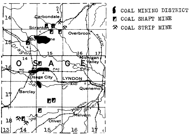
Coal was discovered in Osage County in l869 and mining has been carried on in that district ever since. The coal occurs near the top of the Severy shale, but a short distance below the Howard limestone. The coal-bearing formations cross the Shawnee-Osage county line north of Carbondale and continue in a southwesterly direction, crossing into Coffey County just north of Lebo. Coal has been mined at various points along this belt, including Carbondale, Scranton, Burlingame, Osage City, Barclay, and east and southeast of Reading. In common with other coal-mining districts in Kansas, this district has been unusually active during the last few years. During 1936, 37 shaft and 12 strip mines were in operation in Osage County, producing 89,865 tons of coal.
Municipalities in Osage County are dependent upon surface water for supply. Smaller amounts of water are available in permeable layers in the valley fill of such streams as the Marais de Cygne. The deeper bed-rock waters are mineralized as a general rule.
Osage County has no oil or gas fields, although a number of tests have been drilled in various parts of the county. It is very doubtful, however, that enough tests have been drilled on well-defined anticlines to the "Siliceous lime" to positively disprove the presence of oil or gas in this county.
All of the limestones belonging in the Shawnee and Wabaunsee groups outcrop in Osage County. Many quarry sites are available.
A deposit of flint gravel occurs in south-central Osage County.
Towns and farms along the Solomon River, which crosses northern Osborne County from west to east, obtain abundant water either from the river itself or by means of shallow wells into the flood plain. Likewise, valley-fill water is available in many other parts of the county along tributaries of either Solomon River or, in the southern part of the county, Saline River. The uplands of western and south-central Osborne County are covered with the Niobrara chalk. At the base of this formation is a sandstone of variable thickness, known as the Codell, which contains sufficient water for local use in some parts of the county. The outcrop of this rock is generally marked by springs.
The northern end of the Fairport pool of Russell County comes within about a mile of southwestern Osborne County. Likewise, the eastern edge of the Laton field in Rooks County is only about a mile from the west boundary of Osborne County. Many wells have been drilled in southwestern Osborne County because of this production to the south and west. So far drilling, has not resulted in the discovery of any commercial oil or gas fields, Osborne County lies on the east flank of the Central Kansas Uplift.
Building stone has been quarried from the Fort Hays member of the Niobrara formation in Osborne County. The courthouse at Osborne, and other buildings in the county, are made with this rock.
Sand and gravel deposits are abundant along the tributaries of Solomon River. In addition many deposits of high terrace limestone gravel have been discovered in widely scattered parts of the county, same of which have been exploited for use in road surfacing.
Practically all of Ottawa County is floored by the Dakota formation. Over most of the county sufficient quantities of water for farm, municipal, and industrial use are available at relatively shallow depths from sandstone layers in this formation.
The nearest oil fields of importance are to the south in McPherson County and to the southwest in Ellsworth County. No deep test wells have been drilled in Ottawa County in recent years. The county lies on the south flank of the Salina Basin between the Central Kansas Uplift and the Granite Ridge.
Sandstone has been quarried in Ottawa County in past years.
Prev--Letters A through F... || Next--Letters P through W...
Kansas Geological Survey, Geology
Placed on web Jan. 28, 2016; originally published June 1, 1937.
Comments to webadmin@kgs.ku.edu
The URL for this page is http://www.kgs.ku.edu/Publications/Bulletins/MRC6/page2.html