![]()
Prev Page--Contents || Next Page--Geohydrology
Introduction
This study of the ground-water resources of Lane and Scott Counties began in 1971 as a cooperative program between the Kansas Geological Survey and the U.S. Geological Survey. Support in the study was provided by the Division of Water Resources of the Kansas State Board of Agriculture and the Division of Environment of the Kansas Department of Health and Environment. The objectives in this study were to (1) determine the availability and amount of ground water in the area, (2) determine the chemical quality of the water and its suitability for various uses, (3) document the extent of development of the groundwater resource and the effects of that development, and (4) describe the future outlook for irrigation in the area.
Data for this report were obtained chiefly in 1971 and 1972; additional data were available from previous investigations by Waite (1947), Prescott (1951), and Bradley and Johnson (1957). Field work for this study consisted of locating all large-capacity wells; collecting discharge and power-consumption data; drilling test holes to determine lithology, hydraulic conductivity, and depth to bedrock; conducting aquifer tests to determine aquifer properties; and collecting water samples for chemical analysis. Data from the investigations are published in Stullken and others (1974).
Lane and Scott Counties are located in western Kansas about midway between the north and south borders. Lane County covers an area of 720 square miles (1,865 km2) and Scott County an area of 724 square miles (1,875 km2).
Lane and Scott Counties are in the High Plains section of the Great Plains physiographic province except for a small area in the eastern edge of Lane cates the township, the second number indicates the County that is included in the Smoky Hills Upland section (Frye and Swineford, 1949). The upland plain slopes gradually eastward from an altitude of 3,170 feet (966 m) near the northwest corner of Scott County to 2,480 feet (756 m) in southeastern Lane County where Hackberry Creek enters Ness County. The High Plains section is characterized by flat to gently rolling uplands, a few shallow valleys, and many undrained depressions.
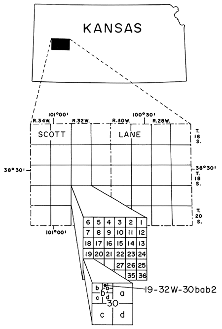
Well-numbering System
The well numbers in this report give the location of wells according to the Bureau of Land Management system of land subdivision. This method of well location is shown in figure 1. The first number indicates the township; the second, the range, and the third indicates the section in which the well is situated. Letters following the section number locate the well within the section. The first letter denotes the quarter section or 160-acre (65 hm2) tract; the second letter, the quarter-quarter section or 40-acre (16 hm2) tract; the third letter, the quarter-quarter-quarter section or 10-acre (4 hm2) tract. These tracts are designated a, b, c, and d in a counterclockwise direction beginning in the northeast quadrant. Where more than one well is in a quarter-quarter-quarter section, consecutive numbers are added to the letter. For example, 19-32W-30bab2 indicates that this is the second well inventoried in the NW NE NW sec. 30, T. 19 S., R.32 W.Figure 1--Location of report area and system of numbering wells and test holes in Kansas.
Prev Page--Contents || Next Page--Geohydrology
Kansas Geological Survey, Geohydrology
Placed on web June 24, 2013; originally published 1976.
Comments to webadmin@kgs.ku.edu
The URL for this page is http://www.kgs.ku.edu/Publications/Bulletins/IRR1/02_intro.html