![]()
Prev Page--Previous Nomenclature, New Findings || Next Page--Memorial Sh, Overlying strata
Lost Branch Formation
The name Lost Branch Formation is proposed for the sequence of gray to black marine shales and thin, pure to impure limestones that extends from the top of the Dawson coal bed and its equivalent strata upward to the base of the terrestrial strata that include the unfossiliferous sandstone that accords with the traditional concept of the Hepler sandstone (fig. 4). As defined, the Lost Branch Formation includes shale formerly encompassed by the Holdenville Shale or Formation as recognized in Kansas and Missouri and shale formerly included in the middle shaly zone of the Seminole Formation as recognized in northeastern Oklahoma. Northward it includes, as named members, the Sni Mills Limestone Member of Missouri at its base and the Cooper Creek Limestone of Iowa, recently correlated into Nebraska using cores, at its top; it also includes the dark shale beneath the Cooper Creek. Southward the Lost Branch Formation encompasses as informally named beds the Nuyaka Creek black shale bed of Bennison (1981), the Glenpool limestone bed of Bennison (1984) at its top, and the Homer School limestone bed of Bennison [1981; emended from Morgan (1924)] at its base; it also includes the associated shaly strata in the upper part of the type Holdenville Shale in east-central Oklahoma and its now-recognized northward extension in northeastern Oklahoma. The Lost Branch is 15 ft (4.6 m) thick in southern Kansas, increasing southward to as much as 65 ft (20 m) in east-central Oklahoma and thinning northward to as little as 4 ft (1.2 m) in the subsurface of southeastern Nebraska.
The Watkins shale member of the Holdenville Shale, informally proposed by Bennison (1984, p. 119) for what was previously regarded as the middle shaly zone of the Seminole Formation by Oakes (1952) in the Tulsa region, includes the Dawson coal and its underlying strata as well as strata above the Glenpool limestone bed and below the Tulsa sandstone. Thus it encompasses more of the sequence than that included in the Lost Branch Formation and therefore does not offer as much stratigraphic differentiation. Furthermore, the name Watkins is preoccupied by a Quaternary unit that is recognized by the U.S. Geological Survey in southwestern Iowa (Keroher, 1970, p. 812).
If the Lost Branch Formation is extended southward as the upper part of the type Holdenville Shale in east-central Oklahoma, then the Holdenville there could be raised to the rank of group and the component beds of the Lost Branch could be raised in rank to member. If the Holdenville is retained as a formation, then the Lost Branch can be recognized as its upper member in that part of Oklahoma, retaining its component beds as currently ranked. If the name Holdenville is retained in the states to the north, then it may be appropriate as a subgroup at the top of the Marmaton Group, composed of, in descending order, the Lost Branch Formation, the Memorial Shale, the Lenapah Limestone, the Nowata Shale, and possibly the Altamont Limestone (after its position in the type area of the Holdenville Shale is resolved).
Type locality and stratotype
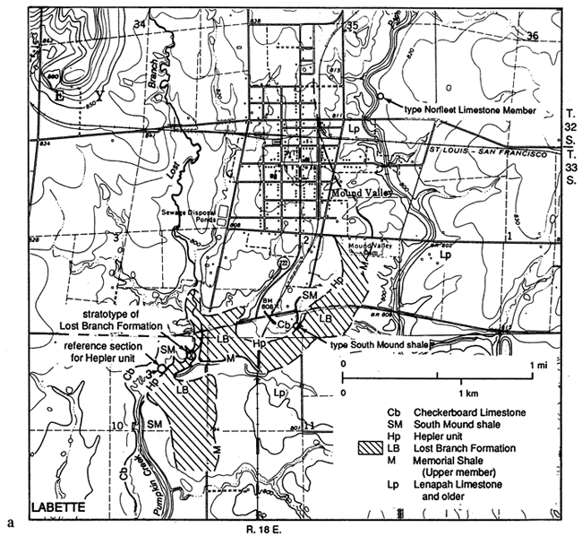
The type locality of the Lost Branch Formation is an excellent exposure in a cutbank on the west side of Lost Branch, near center NE NE NE sec. 10, T. 33 S., R. 18 E., just southwest of Mound Valley, Labette County, Kansas (fig. 5). The stratotype of the Lost Branch (fig. 6) is nearly 15 ft (4.5 m) thick and consists of, in ascending order, (1) 0.3 ft (0.1 m) of slightly micaceous, sandy, soft dark-gray shale (unit 4 in fig. 6) that contains abundant megaspores, carbonized wood fragments, weathered invertebrate skeletal debris, including a small gastropod, and sparse conodonts; (2) 1.3 ft (0.4 m) of fissile black shale (unit 5) with phosphorite laminae and nodules and an abundant and diverse fauna of conodonts; (3) 12 ft (3.6 m) of gray shale (unit 6) that becomes micaceous and silty upward and carries an abundant and diverse invertebrate fauna, particularly in the lower part, including crinoid debris, brachiopods, bryozoans, gastropods, ostracodes, foraminifers, pelecypods, and scattered conodonts; and (4) 1 ft (0.3 m) of hard, calcareous, fossiliferous, very fine grained quartz sandstone to sandy skeletal calcarenite (unit 7) containing brachiopods, crinoid debris, foraminifers, and sparse conodonts.
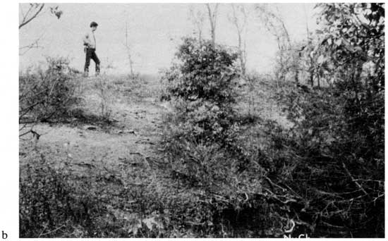
Figure 5--Type section of the Lost Branch Formation. (a) Geologic map of part of the 1974 Mound Valley, Kansas, 7.5' Quadrangle showing location of stratotype (X) of Lost Branch Formation, on Lost Branch, a recently named (1984) tributary to Pumpkin Creek, near the center of NE-NE-NE sec. 10, T. 33 S., R. 18 E., Labette County, Kansas. This exposure apparently was illustrated as units 1-6 in a diagram by Moore (1937, p. 34), which, although mislocated as "Section in NE-NW sec. 10, T. 33 S., R. 18 E.," was discussed on p. 33 as being in NE sec. 10. This exposure and its critical relationships had apparently been "lost" to geologic endeavor [Oakes and Jewett (1943, section 22) and Jewett (1945, section 156) reported similar-looking (the same?) sequences from NW sec. 11 and NE sec. 11, respectively] until it was rediscovered and shown to me by A. P. Bennison in 1982 when I was preparing to search for the exposure based on Moore's locality; this is why the name Lost Branch is applied to the tributary. The locality marked "3" shows the reference section for the Hepler unit, which overlies the Lost Branch Formation. (b) Photograph of the stratotype of the Lost Branch Formation in 1985, looking northwest, at locality marked "X" in fig. 5a. W. L. Watney is standing on the sandy limestone ledge (unit 7 in fig. 6) correlated with the Glenpool limestone bed; the Nuyaka Creek black shale bed (NyCk) and Dawson coal are exposed in the base of the bank.
The fissile, phosphatic black shale (unit 5 in fig. 6) is the Nuyaka Creek black shale bed of Bennison (1981). It carries the same distinctive abundant conodont fauna as that described by Jones (1935, 1941) from the black shale above the Dawson coal at Collinsville, Oklahoma, and that described by Swade (1982, 1985) from the thin shale below the Cooper Creek Limestone in Iowa. The lateral persistence of this conodont-rich horizon of sediment starvation provides the basis for internal stratigraphic differentiation of the Lost Branch Formation, and the distinctive nature of its conodont fauna allows lithic and faunal correlation of the Lost Branch along the midcontinent outcrop belt (figs. 7 and 8), and among cores across the subsurface of the Forest City basin (fig. 9).
Figure 6--Measured section of stratotype of the Lost Branch Formation along Lost Branch. This figure is a composite with sections of higher strata exposed to the southwest in gullies and highbanks of Pumpkin Creek, all in NE sec. 10, T. 33 S., R. 18 E., 1 mi (1.6 km) southwest of Mound Valley, Labette County, Kansas. The exact locations of individual sections that form the composite are indicated on the right-hand side. The formal rank for the Hepler unit and the classification of it and higher units have not yet been decided. This section (outcrop 19 in figs. 7 and 8) is the same as that illustrated by Moore (1937, p. 34) and by Bennison et al. (1984, p. 25), both of whom identified unit 7, now defined as the top of the Lost Branch Formation, as all or part of the Hepler sandstone.
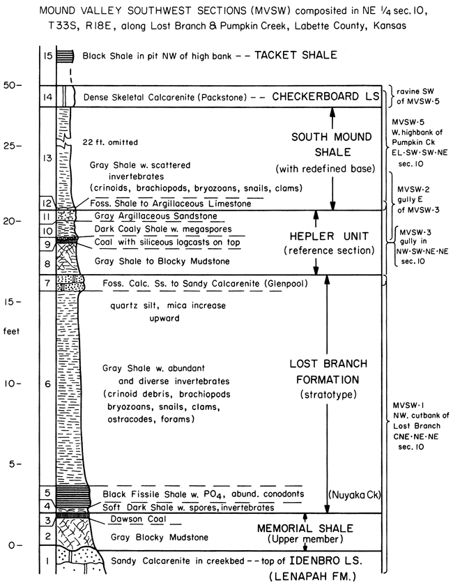
Figure 7--Locations of exposures (x) of Lost Branch Formation and associated units along outcrop belt, locations of cores (lettered circle with dot) that contain Lost Branch strata, and lines of cross sections illustrated in figs. 8 and 9. Exact locations of all exposures and cores are given in the appendix.
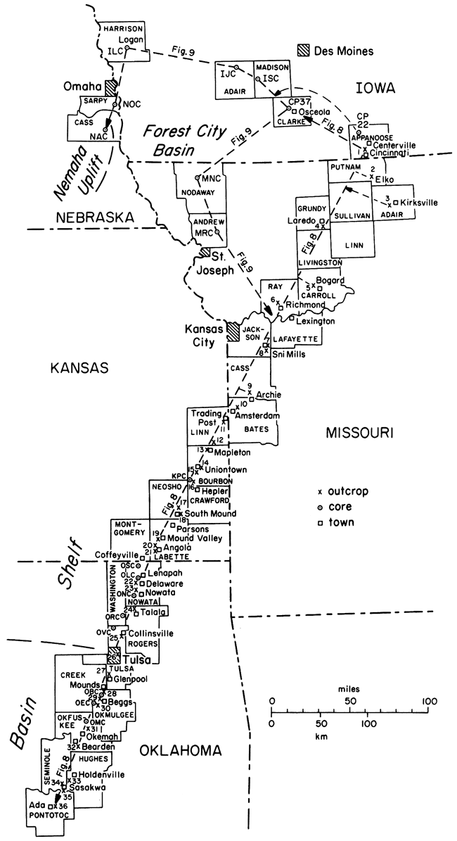
Figure 8--Cross section along outcrop of Lost Branch Formation (delimited by thickest lines) and adjacent strata, based on measured sections (numbered or lettered vertical lines) located in fig. 7 and described in the appendix. Horizontal scale is approximate. Vertical exaggeration is roughly 26,000 times. Where a thick unit would cause excessive vertical distortion, the amount of footage that is indicated by a plus sign is omitted. The main datum is the base of the black fissile, phosphatic shale horizon (Nuyaka Creek black shale bed) and the equivalent conodont-rich gray shale. Lithic symbols are standard or labeled, with carbonate widely vertically lined, coal closely vertically lined, blocky mudstone ("clay") lightly shaded, red mudstone more darkly shaded, and gray shale left blank or marked by dashes within limestone unit. Type sections or type areas of named units are marked with asterisks. See fig. 9 for relations in Iowa, Nebraska, and northwestern Missouri. Sources of measured sections and other stratigraphic information are given in the appendix. [An Acrobat PDF version of this image is available.]
The overlying fossiliferous gray shale (unit 6) at the type section carries a diverse macrofauna, including the brachiopod Mesolobus, which facilitated the shale's classification as Desmoinesian by Moore (1937, p. 34) and by Oakes and Jewett (1943) in nearby outcrops (Oakes and Jewett, 1943, sections 18, 21, and 22) in the Mound Valley area. It is possible that this horizon also is the fossiliferous shale collected about 3 mi (5 km) to the northeast as "Perry Farm" by Spencer (1978, p. 1360, locality 11).
The capping calcareous, fossiliferous sandstone horizon (unit 7 in fig. 6) was classified by Moore (1937, p. 34) as the base of the Missourian Series. It was regarded by Oakes and Jewett (1943, section 22) as the Hepler sandstone, which had been believed by Jewett (1940, p. 8) in his original description of the Hepler to grade laterally in central Labette County into a sandy limestone containing marine fossils. In a gully just to the southwest of the type section (location 3 in fig. 5), this fossiliferous sandstone is overlain by an underclay and a coal, which is overlain by a dark carbonaceous shale and a more friable sandstone (units 8-11 in fig. 6). Because the marine sandy limestone-calcareous sandstone (unit 7) is merely an upward continuation of the marine strata forming the main part of the Lost Branch Formation (units 4-6) and because the unit is overlain by a nonmarine coal with underclay and an associated sandstone (unit 11) that could be considered the Hepler sandstone, this marine sandstone is included as the top of the Lost Branch Formation. It is considered a probable northern time equivalent of the Glenpool limestone bed of Bennison (1984) in northeastern Oklahoma, rather than the lower bed of the Hepler as illustrated by Bennison et al. (1984, p. 25).
Component units
Several previously named lithic units are recognized as components of the Lost Branch Formation along parts of the outcrop belt. Because not all units are present in the stratotype for the formation, they are briefly described with information appropriate to their definition and recognition.
Sni Mills Limestone Member
The Sni Mills Limestone Member was named by F. C. Greene (Moore et al., 1936, pp.18-20) from a creek bed exposure in NW sec. 28, T. 48 N., R. 29 W., at Sni Mills in Jackson County, east of Kansas City, Missouri (outcrop 7 in figs. 7 and 8). It was considered the upper member of the Lenapah Formation by Greene and Searight (1949) and was recognized as having priority over Jewett's (1941) name, Idenbro, for the upper member of the Lenapah Limestone in Kansas by Cline and Greene (1950), who suggested suppression of the name Idenbro. The Idenbro Limestone Member lies at the top of the Lenapah Limestone and below the Dawson coal in their type areas, whereas the Sni Mills Limestone Member lies above the horizon of the Dawson coal and is not part of the Lenapah but rather the basal bed of the Lost Branch Formation (fig. 8). Consequently, the Sni Mills and Idenbro Members are not correlative, and both names are retained as valid.
The Sni Mills Limestone Member is characteristically a single ledge of dense skeletal calcilutite like most other Pennsylvanian transgressive limestones, and it lies everywhere beneath a conodont-rich, gray to black phosphatic shale (fig. 8). Its field appearance was thoroughly described by Howe (1953). The Sni Mills Member ranges in thickness on outcrop from 1 ft (0.3 m) near the Kansas-Missouri border, thinning generally northward through 0.4 ft (0.1 m) in Missouri, to only 0.1 ft (0.03 m) in those cores in Iowa and southeastern Nebraska where it is still present (fig. 9). Southward, for example, at Trading Post, Kansas, it is developed as lenses up to 1 ft (0.3 m) thick that extend for several feet along the outcrop. The limestone grades laterally both northward and southward into the base of the overlying marine shale or into a diastemic surface between the overlying shale and the underlying terrestrial rocks. The Sni Mills Member carries an open-marine biota consisting largely of brachiopods, crinoid material, bryozoans, foraminifers, gastropods, and phylloid algal blades. A good principal reference section is a creek bank exposure 2 mi (3 km) south of the type section (outcrop 8 in figs. 7 and 8); other good exposures are in the bank of the Marais des Cygnes River at Trading Post, Linn County, Kansas (outcrop 11), and high in the railroad cut just northwest of Richmond, Missouri (outcrop 6).
Figure 9--Cross section of upper Desmoinesian (Marmaton Group) and lower Missourian (Pleasanton Group and Bronson subgroup) strata around the Forest City basin based on cores (located in fig. 7) and on outcrops in the Kansas City-Lexington area of Missouri [compiled from Cline (1941), Howe (1953, 1982), and Parizek and Gentile (1965, p. 16)]. The names shown are mainly those of marine, dominantly limestone formations. The new Iowa nomenclature is that of Ravn et al. (1984). Correlations are based on characteristic conodont faunas for those units marked with "tailed-diamond" symbols, after the zonation of Swade (1985; based on faunas in cores CP-37 and CP-22) and supplemented by later work and on fusulinid faunas for those units marked with"E" (Eowaeringella ultimata) and "t" (lowest triticitids), based on identifications by J. R. Meacham, as reported by Heckel and Meacham (1981). Units in the Amerada core (NAC) were correlated by Condra (1939) as follows: Altamont Limestone with Pawnee Limestone (questioned); Lost Branch Formation with Hertha Limestone; Exline limestone with Middle Creek Limestone Member (lower Swope Limestone); Hertha Limestone with Bethany Falls Limestone Member (upper Swope Limestone); Swope Limestone with Dennis Limestone (Winterset Limestone Member); and Dennis Limestone with parts of Westerville Limestone Member and Cherryvale Formation. The Dennis Limestone later was termed the Sarpy Formation in Nebraska (Condra, 1949, p. 37) and correlated with the three middle members (Block, Wea, and Westerville) of the Cherryvale Shale of Kansas; according to correlations established by conodonts and fusulinids shown here, "Sarpy" is a junior synonym for the Dennis Limestone. Locations of all cores and brief descriptions of the Lost Branch Formation and adjacent strata in them are given in the appendix. [An Acrobat PDF version of this image is available.]

Cooper Creek Limestone Member
The Cooper Creek Limestone was named by Cline (1941, p. 65) from outcrops along tributaries to Cooper Creek in SE sec. 26, T. 69 N., R. 18 W., on the west side of Centerville, Appanoose County, Iowa (fig. 7). The principal reference section is an outcrop in the northwest comer of the old quarry southeast of the entrance to the Appanoose County dump (SW NW sec. 27, T. 68 N., R. 18 W.), 6 mi (10 km) south of the type area and 2 mi (3 km) north of Cincinnati, Iowa (outcrop 1 in figs. 7 and 8). The Cooper Creek Limestone was correlated with the Sni Mills Limestone Member by Howe (1953), who suggested suppression of the name Cooper Creek. Because the Cooper Creek lies everywhere above the conodont-rich dark-gray to green phosphatic shale, whereas the Sni Mills lies everywhere below it (fig. 8), the two units are not correlative, and both names are valid for upper and lower limestone members, respectively, of the Lost Branch Formation. The two limestones are known to occur together with the thin intervening conodont-rich shale in three cores from Iowa (CP-37 from Clarke County, ISC from Madison County, and IJC from Adair County) and one core from Nebraska (NAC from Cass County) (fig. 9).
The Cooper Creek Limestone Member is characteristically a light-gray fragmental to nodular skeletal calcilutite with many spar-filled voids and fractures. It contains admixed green clay, the amount of which increases upward in places to surround nodules of limestone and form a transition to the overlying blocky mudstone. The Cooper Creek Member is 8 ft (2.4 m) thick in the core at Osceola (CP-37) and thins southeastward on outcrop to 4 ft (1.2 m) in the type area before grading into shale near the Iowa-Missouri border (fig. 8). Westward and southwestward it ranges from 2 ft (0.6 m) to 7 ft (2.1 m) thick in the cores from western Iowa, southeastern Nebraska, and northwestern Missouri (fig. 9). The Cooper Creek Member carries an open marine biota consisting largely of brachiopods, crinoid material, bryozoans, small foraminifers, snails, fragmental phylloid algae, and, locally, fusulinids.
Homer School limestone bed
The Homer School limestone bed was originally named the Homer limestone member of the Holdenville Shale by Morgan (1924, p. 104) from an exposure in the south-central part of sec. 25, T. 4 N., R. 6 E., just west of Homer School, east of Ada, Pontotoc County, Oklahoma (outcrop 36 in figs. 7 and 8). Because Branson (1957) rejected the name, citing its preoccupation by a Cretaceous unit in Idaho, without providing a replacement, Bennison (1981, p. 5) suggested using the name Homer School limestone bed, which is accepted herein. Because the Homer School limestone bed underlies the conodont-rich Nuyaka Creek black shale bed (fig. 8) and overlies terrestrial deposits (Dott and Bennison, 1981), it is a transgressive limestone, the southern lithic counterpart and correlative of the Sni Mills Limestone Member.
Between Ada and Sasakwa the Homer School limestone bed is a dark chaetetid-rich limestone 3 ft (1 m) thick; south of Ada it grades abruptly into even darker fusulinid limestone and disappears in a short distance (Morgan, 1924). In the Sasakwa area it is a skeletal calcilutite with crinoid debris, brachiopods, bryozoans, chaetetids, small corals, and other invertebrates. Because Morgan's (1924) original exposure near Homer School has not been rediscovered, the exposure in the road ditch south of Sasakwa (outcrop 35) is chosen as the principal reference section. Northward the Homer School limestone bed thins to about 1 ft (0.3 m) of phylloid algae-rich calcilutite before grading northward into calcareous shale between Sasakwa and Holdenville (Bennison, 1981). Other reference sections include the creek bed east of the northwest comer of sec. 36, T. 6 N., R. 7 E., just north of Sasakwa (near outcrop 34 in figs. 7 and 8), and a road cut along the center west line of SW-SW-NW sec. 8, T. 6 N., R. 8 E., west of Spaulding, between Sasakwa and Holdenville (near outcrop 33 in figs. 7 and 8).
Nuyaka Creek black shale bed
The Nuyaka Creek black shale bed was named informally by Bennison (1981, p. 5) for a 5-8-ft (1.5-2.4-m) thick black clayey shale with phosphorite nodules that crops out along the banks of Nuyaka Creek. The type section is just west of the 0-56 bridge near the center east line of NE sec. 32, T. 12 N., R. 10 E. [emended from Bennison (1981)], 3 mi (5 km) northeast of Okemah, Okfuskee County, Oklahoma (outcrop 31 in figs. 7 and 8). Because of incomplete exposure at the type section, the principal reference section is chosen 12 mi (19 km) to the southwest in the ravine 2 mi (3 km) southeast of Bearden (outcrop 32), where a complete vertical sequence is exposed. The Nuyaka Creek black shale bed is traced southward through Hughes and Seminole counties, where it and adjacent lighter shales occupy the upper part of the Holdenville Shale, above the Homer School limestone bed and below the irregular basal sandstone of the Seminole Formation. The Nuyaka Creek black shale is typically hard and fissile as it is traced northward through numerous localities, including Beggs, Tulsa, Collinsville, and Nowata in Oklahoma [where it thins to about 1 ft (0.3 m)], Mound Valley, South Mound, Uniontown, Mapleton, and Trading Post in Kansas, and Amsterdam, Archie, Sni Mills, Richmond, Laredo, and Kirksville in Missouri (figs. 7 and 8). In north-central Missouri the black fissile shale facies grades laterally into a soft black clayey facies [e.g., near Kirksville (outcrop 3)] and into a dark-green-gray clayey but still phosphatic, conodont-rich shale facies along the Iowa outcrop belt and in most of the cores from the Forest City basin (fig. 9).
At present, it seems preferable to retain the name Nuyaka Creek for only the distinctive black shale bed as originally named, rather than to expand it to include all the gray marine shale within the Lost Branch Formation. The black shale facies is easily identified on gamma-ray logs in the subsurface of eastern Oklahoma (Bennison, 1981) and east-central Kansas (Sutton, 1985) (fig. 10). Throughout much of eastern Kansas the high gamma-ray peak of the Nuyaka Creek black shale readily marks the position of the Lost Branch Formation, 30-50 ft (9-15 m) above the black Lake Neosho Shale Member in the Altamont Limestone. This position also ranges from 50 ft (15 m) below the two black shales in the Tacket Formation in the south to 100 ft (30 m) or more below the lower Tacket (Mound City) black shale (classified in the Hertha Limestone) toward the north (fig. 10).
Figure 10--Gamma-ray and neutron logs of cored well drilled west of Prong Creek (KPC in fig. 7) in Southwestern Bourbon County, 9 mi (15 km) south-southwest of Uniontown. The logs show the characteristic signatures of stratigraphic units recognized in this core and described in the appendix. Note the distinctive high gamma-ray ("hot") signature of the Nuyaka Creek black shale bed of the Lost Branch Formation in its typical position low in the thick sequence of shale with scattered sandstone and thin limestones that lies above the distinctive Altamont Limestone with its medial "hot" shale (black Lake Neosho Shale Member) and below the three characteristic thick limestones (Hertha, Swope, and Dennis) of the lower Kansas City Group (Bronson subgroup). The next "hot" shale upward (basal black shale bed of the Mound City Shale Member of the Hertha Limestone, just above the top of the Pleasanton Group) converges northward with the Sniabar Limestone Member of the Hertha Limestone; southward it becomes the lower black shale in the Tacket Formation as it converges with the higher "hot" black Hushpuckney Shale Member, which becomes the upper Tacket black shale south of the pinchout of the Sniabar Limestone Member. Note that without conspicuous sandstone at the base of the Pleasanton in the traditional Hepler interval, the top of the Lost Branch Formation (hence the Desmoinesian-Missourian boundary as currently identified) is difficult to determine on geophysical well logs. Note also that without conspicuous limestone in the Lenapah interval, the entire interval from the Altamont Limestone to the Lost Branch Formation becomes undifferentiated Nowata-Memorial Shale. Kansas Geological Survey, Troike #1, SE SE NE SE sec. 5, T. 27 S., R. 22 E., Bourbon County, Kansas.
The fauna of the Nuyaka Creek black shale bed and its northern lateral equivalent is strongly dominated by a distinctive assemblage of conodonts, which are extremely abundant (10,000/kg) where the horizon is thinnest in the north. Limestone nodules in the black shale at Collinsville, Oklahoma, and Archie, Missouri, yield ammonoids (Miller and Owen, 1937; Boardman and Mapes, 1984).
The underlying thin gray shale (unit 4 of the stratotype; fig. 6) thickens southward at places to 3 ft (0.9 m) near Nowata and to 7 ft (2.1 m) locally near Glenpool, south of Tulsa, where it contains limestone concretions. This shale ranges from at least 5 ft (1.5 m) to less than 1 ft (0.3 m) farther southward, where its contact with the black shale becomes more transitional. The gray shale is at least in part the lateral equivalent of both the Sni Mills Limestone Member and the Homer School limestone bed (fig. 8). It contains a fauna of brachiopods, crinoid debris, and snails adjacent to the lens of Sni Mills limestone at Trading Post, Kansas.
The overlying gray shale unit ranges from 7 ft to 14 ft (2. 1 4.3 m) in thickness in most of Kansas and Missouri down to a few inches beneath the Cooper Creek Limestone Member in Iowa. From 12 ft (3.7 m) at the Lost Branch type section (unit 6 in fig. 6) it thins southward to 1-2 ft (0.3-0.6 m) in Nowata County, Oklahoma, and thickens to 25 ft (7.6 m) near Glenpool, Tulsa County, all beneath the Glenpool limestone bed. Farther southward it ranges from 15 ft (4.6 m) to 55 ft (17 m) in east-central Oklahoma, where it grades upward into thin-bedded sandstones (as seen in the Oklahoma Geological Survey cores from Beggs to Okemah) and into red shales farther south (Dott and Bennison, 1981, pp. 18, 20). The gray shale is conspicuously fossiliferous in several places, such as around Mound Valley, Kansas, and Glenpool, Oklahoma, where brachiopods, crinoids, and bryozoans dominate the fauna, which also includes ostracodes, clams, and snails. At places southward, near Holdenville, mollusks of all types (Malinky, 1984) predominate in the lower part, along with ammonoids (Boardman et al., 1984). The fauna at the top near Sasakwa is dominated by brachiopods, especially chonetids, and includes bryozoans and crinoid debris. At least the upper part of this gray shale unit is the southern lateral equivalent of the Cooper Creek Limestone Member from Missouri southward, and the top of this shale in places is the lateral equivalent of the lenticular Glenpool limestone bed.
The best exposed and most easily accessible reference sections of the Nuyaka Creek black shale bed are found in the river bank at Trading Post, Kansas (outcrop 11 in fig. 8), in the railroad cut north of Richmond, Missouri (outcrop 6), in the creek bed at Walley Mound near Amsterdam, Missouri (outcrop 10), in the Lost Branch stratotype near Mound Valley, Kansas (outcrop 19), in the stream bank at the tank farm north of Glenpool, Oklahoma (outcrop 27), and at the principal reference section in the ravine near Bearden, Oklahoma (outcrop 32). The adjacent shales are best exposed near Sni Mills (outcrop 8), Trading Post (outcrop 11), Lost Branch (outcrop 19), Glenpool (outcrop 27), Bearden (outcrop 32), and Sasakwa (outcrop 35, especially the upper part).
Glenpool limestone bed
The Glenpool limestone bed was named informally by Bennison (1984, p. 118) from an outcrop on US-75, along the west line of SW NW NW sec. 23, T. 17 N., R. 12 E., just south of Glenpool, Tulsa County, Oklahoma. The principal reference section showing the bed's relationship to the rest of the Lost Branch Formation is found northward 3 mi (5 km) along US-75 (west line of NW-NW-SW sec. 2, T. 17 N., R. 12 E.; outcrop 27 in figs. 7 and 8). The Glenpool bed is nearly everywhere 1 ft (0.3 m) or less of orange- to yellow-weathering, impure limestone to dolomite and ranges from sandy to shaly skeletal calcarenite to calcilutite. It can be traced from the type section northward about 3 mi (5 km), where it becomes lenticular and eventually disappears in the Tulsa-Collinsville region. Southward the Glenpool can be traced past Beggs in Okmulgee County, where it becomes quite sandy. It reappears northward in Nowata County and again around Mound Valley in Labette County, Kansas, where it is unit 7 in the Lost Branch stratotype (fig. 6); here the Glenpool is again sandy enough in places to have been misidentified as the Hepler sandstone. Northward, near Uniontown (outcrop 15) in Bourbon County, the Glenpool limestone bed is composed of a conglomeratic limestone overlain by fossiliferous shale and shaly limestone that aggregate a sequence 4 ft (1.2 m) thick. Where contacts are observed, the Glenpool limestone bed is underlain by gray fossiliferous marine shale of the upper Lost Branch Formation and overlain by underclay and coal or sandy shale and sandstone of the overlying formation (fig. 8).
The Glenpool limestone bed contains an abundant and diverse marine biota dominated in most places by brachiopods, bryozoans, and crinoid debris but locally by phylloid algae (northwest of Nowata, outcrop 23). The biota also includes snails, clams, foraminifers, ostracodes, and coaly plant fragments. The Glenpool is laterally equivalent to the top of the gray fossiliferous shale that overlies the Nuyaka Creek black shale bed, and the lateral transition is displayed locally by the extremely shaly sequence near Uniontown. Because it is regressive and more basinal, the Glenpool is probably slightly younger than the top of the Cooper Creek Limestone Member of Iowa. Other reference sections include the ravine exposure near Uniontown (outcrop 15 in figs. 7 and 8); the Lost Branch Formation stratotype (outcrop 19); a creek bank near the KGGF radio tower (outcrop 20) about 4 mi (6.4 km) southwest of the Lost Branch type section; in Wolf Creek west of Delaware, Oklahoma (outcrop 22); along Mormon Creek northwest of Nowata (outcrop 23); along South Duck Creek west of Alt. US-75, south of Mounds (outcrop 28); and in the creek bed near Dentonville, southwest of Beggs in Okmulgee County (outcrop 30).
Contacts
The lower contact of the Lost Branch Formation at the type section is the contact between the base of the lower dark-gray shale (unit 4 in fig. 6) and the top of the Dawson coal (unit 3). The Dawson coal is traceable southward through the Tulsa region into Okfuskee County and therefore provides a good marker horizon below the base of the Lost Branch throughout the area (fig. 8). Northward the Dawson coal thins and becomes discontinuous where the Lost Branch is seen in Kansas and most of Missouri, but the gray blocky mudstone (unit 2 in fig. 6) that underlies the Dawson coal as its seat earth extends far beyond the extent of the coal and serves as an excellent marker horizon below the base of the Lost Branch, whether the coal is present or not. Similar blocky mudstones that locally are seat earths are paleosols that represent widespread emergence and subaerial weathering for some period of time (Schutter and Heckel, 1985; Goebel et al., 1989). Consequently, the lower contact of the marine Lost Branch Formation is a terrestrial surface upon which marine transgression took place. Therefore the contact is a disconformity, and there may be slight angular discordance near Laredo, Missouri, where the Lenapah Limestone is absent (outcrop 4 in fig. 8). Thus recognition of the surface that separates marine deposits above from terrestrial deposits below helps to determine the basal contact of the Lost Branch Formation in areas where lithologies are different from those at the type section. For example, the Sni Mills Limestone Member, which forms the base of the Lost Branch Formation in much of Missouri, typically overlies blocky mudstones, called "clays" or shale with "conchoidal fracture" by Howe (195 3), as well as local sandstone, sandy shale, and coal. The Homer School limestone bed, at the base of the Lost Branch Formation in east-central Oklahoma, typically overlies gray to reddish silty shale to sandstone, considered fluvial in origin by Dott and Bennison (1981).
The upper contact of the Lost Branch Formation is not well exposed in the stratotype, where the capping fossiliferous calcareous sandstone (unit 7 in fig. 6) forms the top of the exposure. However, in a small gully just to the southwest (location 3 in fig. 5a) the overlying strata exhibit a sharp contact with the calcareous sandstone. These overlying beds are termed the Hepler unit (see the later discussion on this unit) and consist of an ascending sequence of blocky mudstone (unit 8 in fig. 6), which probably is a paleosol, overlain by a coal informally called the "Hepler" coal (unit 9); this is overlain in turn by a dark coaly shale that contains only megaspores (unit 10) and a friable sandstone considered the traditional Hepler sandstone (unit 11), both representing alluvial deposits. Thus the strata overlying the type Lost Branch Formation also are terrestrial, with a paleosol representing subaerial exposure at the upper contact of the Lost Branch. This is the general situation seen along much of the outcrop belt, except where later channeling has removed the higher strata, as in the South Coffeyville Core (OSC) taken just south of the Kansas-Oklahoma border (fig. 8). Where the upper limestones (Cooper Creek, Glenpool) exist in the Lost Branch Formation, each stands out conspicuously as a marine bed belonging to the Lost Branch, and the upper formational contact is placed at its top. The Cooper Creek and Glenpool limestones are overlain in most places by blocky mudstone. Where the top of the Lost Branch is shale, any noticeable upward change from fossiliferous marine shale to unfossiliferous terrestrial shale or sandstone is chosen as the contact. Where Lost Branch shale is overlain by unfossiliferous sandstone that is not definitely part of the continuous marine sequence (as unit 7 is at the type section), the contact is placed at the lowest conspicuous, laterally persistent sandstone bed (fig. 8); this type of contact is also seen along much of the outcrop, and it may mark either an upward transition into a shoreline distributary mouth bar or terrestrial deposit, or a minor erosional disconformity below a later alluvial channel.
Basis for correlation
The main basis for chronostratigraphic correlation of the Lost Branch Formation along the midcontinent outcrop belt and into the subsurface is the upper Desmoinesian conodont biostratigraphy established in Iowa by Swade (1982, 1985). Other biostratigraphic investigations currently underway by D. R. Boardman, R. H. Mapes, and D. M. Work on ammonoids and by R. A. Peppers on palynomorphs will be published in detail elsewhere. Their findings so far are in accord with the conodont information with respect to vertical and lateral extent and correlation of the Lost Branch Formation.
Conodonts
Swade (1985) established a biostratigraphic zonation for six major upper Desmoinesian marine horizons in two overlapping cores from south-central Iowa (CP-22 and CP37 in figs.7 and 9). Swade characterized the conodont faunas from the Oakley Shale Member [lower Swede Hollow (=Verdigris) Formation], the Excello Shale Member (lower Fort Scott Limestone), the Little Osage Shale Member (upper Fort Scott Limestone), the Anna Shale Member (Pawnee Limestone), the Lake Neosho Shale Member (Altamont Limestone), and the shale below the Cooper Creek Limestone Member, now recognized as part of the Lost Branch Formation (figs. 8 and 9). As a result of Swade's tutelage before his untimely death in March 1983, my students and I have been able to supplement this zonation above and below the Lost Branch Formation for the underlying Lenapah Limestone (Parkinson, 1982; Greenberg, 1986) and for the overlying Tacket Formation in southern Kansas and Oklahoma (Pavlicek, 1986) and the Exline limestone in Missouri and Iowa (Nielsen, 1987). The horizon of the Lenapah Limestone in the Iowa core (CP-37) that Swade (1982) studied is occupied by a nondiagnostic nearshore Adetognathus fauna [D. Lipsius-Swade, in Swade (1985)], and Greenberg (1986) showed that the diagnostic forms of Neognathodus appear in this horizon only as far north as north-central Missouri.
A brief résumé of the conodont faunas of the Altamont, Lenapah, Lost Branch, and Exline horizons is presented next to establish the uniqueness of the fauna characterizing the Lost Branch Formation.
The Lake Neosho Shale Member, which is the medial phosphatic shale of the Altamont Limestone, carries a distinctive fauna [scratch marks (#) in figs. 3 and 4] dominated by many species of Neognathodus and by Idiognathodus sp. 5 of Swade (1985), a distinctly troughed form that appears to be nearly confined to this horizon. Idioprioniodus is also present, but Gondolella is absent. This fauna has been recovered from the Altamont in other cores from Iowa, Nebraska, and Missouri (fig. 9), from the type section of the Lake Neosho Shale Member in Neosho County, Kansas, and from localities that had been regarded as the base of the Nowata Shale (fig. 3) in the Tulsa area. It also has been found in samples of the Tuckabatchee shale of Bennison (1984) and the underlying limestone [Yeager limestone of Bennison (1981)] from several localities in east-central Oklahoma.
The basal beds of the Lenapah Limestone carry an extremely distinctive fauna [plus signs (+) in figs. 3 and 4] dominated by a small species of Neognathodus, described as new by Parkinson (1982, pp. 86-87) after consultation with J. W. Swade; it is illustrated by Greenberg (1986, fig. 28). This fauna includes other species of the same genus [described by Merrill (1975)] and contains a small number of Adetognathus. However, unlike any other fairly widespread marine horizon in the midcontinent Desmoinesian-Missourian marine sequence, this fauna contains only a small number of Idiognathodus, many of which are juvenile. Both Idioprioniodus and Gondolella are absent. This fauna has been found in the Eleventh Street limestone at several localities from a new exposure south of Tulsa to the Lenapah type area, in the basal bed of the Norfleet Limestone Member at its type section at Mound Valley, and in other shale and limestone beds assignable to the Norfleet at several localities in southeastern Kansas and northwestern Missouri (including core MRC in fig. 9); Adetognathus progressively increases in proportion northward (Greenberg, 1986). A similar fauna consisting entirely of several species of Neognathodus was recovered from a shale sample collected by A. P. Bennison, 70 ft (21 m) below the Nuyaka Creek black shale bed (Lost Branch Formation) and 20 ft (6.1 m) above the lower Holdenville sandstone south of Okemah and southeast of Bearden (near outcrop 32 in figs. 7 and 8) in Okfuskee County near the type area of the Holdenville Shale; this is a horizon that Bennison (1984, p. 115) has designated informally as the High Spring shale (figs. 4 and 8).
The thin shale below the Cooper Creek Limestone Member (Lost Branch Formation) in the Iowa core studied by Swade (1982, 1985) carries a distinctive conodont fauna dominated by Idiognathodus sp. 6 of Swade (1985), which is another distinctively troughed form and one that appears nearly confined to this horizon. Idiognathodus sp. 1 of Swade (1985), Gondolella sp. 3 of Swade (1985), Idioprioniodus, and several species of Neognathodus are also present. All these forms were illustrated by Jones (1935) from the black shale above the Dawson coal at Collinsville, Oklahoma (outcrop 25 in fig. 8), where they have been confirmed by re-collection. I have recovered this fauna from a single horizon in several cores in Iowa, Nebraska, and Missouri (fig. 9) and from many outcrops of the black shale at the base of the Holdenville Shale as previously recognized in Missouri and Kansas, from the black shale above the type Laredo coal near Laredo, Missouri (Howe, 1953, p. 26), which had been referred to the Nowata formation, from the black shale above the Dawson coal at many localities extending from southern Kansas to well south of Tulsa, and from the upper Holdenville Shale in its type area in east-central Oklahoma [all indicated by hatch marks (///) in figs. 3 and 4]. It also has been recovered from a green-gray shale in the lower part of the Lonsdale Limestone Member at a locality between Galesburg and Peoria, Illinois (which was studied by J. W. Swade for his Senior Honors thesis project at Knox College), and from a gray shale in the West Franklin Limestone Member in a core taken at Charleston in east-central Illinois. This widespread distinctive fauna allows correlation of the Lost Branch Formation not only all along the midcontinent outcrop belt and into the near subsurface but also into the Illinois basin, where it confirms Weller et al.'s (1942) correlation of the Lonsdale Member with the Cooper Creek Limestone Member of Iowa.
The fauna of the Exline limestone, which lies with apparent disconformity on top of the Cooper Creek in Iowa core CP-37 studied by Swade (1985), is strongly dominated by a species of Idiognathodus that has a relatively narrow, flat to slightly troughed platform marked by distinct transverse ridges. This species was included within Idiognathodus sp. 1 by Swade (1985) and Pavlicek (1986). Small numbers of Adetognathus, Anchignathodus, and Idioprioniodus are also present. Neognathodus and Gondolella are absent. This fauna has been recovered from both limestone and shale at several Exline localities throughout north-central and western Missouri and in eastern Kansas and eastern Oklahoma, where Pavlicek (1986) found it in the base of the Tacket Formation (fig. 4). Northwestward in cores from western Iowa and Nebraska, Adetognathus increases in abundance to dominate the fauna in the Exline limestone (Nielsen, 1987).
Ammonoids
Boardman et al. (1984) briefly summarized the current knowledge of ammonoid generic occurrences in the midcontinent. Boardman and Mapes (1984) discussed the changeover in ammonoid species at the Desmoinesian-Missourian boundary and explicitly corrected the miscorrelation of the Collinsville locality and the resulting confusion that arose when Miller and Owen (1937) regarded the ammonoid fauna there as early Missourian. Boardman and Mapes (1984) showed that the Collinsville fauna is equivalent to faunas from the upper Holdenville Shale in its type area and from the base of the Holdenville Formation as previously recognized in Missouri. Chatelain (1984) described a number of new ammonoid species from Oklahoma, including the Collinsville locality. Most recently, Boardman et al. (in press) have updated the ammonoid biostratigraphy for the Desmoinesian-Virgilian sequence in the midcontinent.
Palynomorphs
Pearson (1975) and Wilson (1979, 1984) first reported the strong Desmoinesian affinities of the flora in the Dawson coal in northeastern Oklahoma and removed it from the Missourian Stage, where it had been placed by Moore et al. (1937). Wilson (1979, 1984) also suggested placing the next higher coal, which he termed "Seminole," in the Desmoinesian as well. From work on the palynomorph floras from a number of midcontinent coal samples spanning the Desmoinesian-Missourian boundary that I provided, R. A. Peppers (personal communications, 1981-1984) has emphatically confirmed the Desmoinesian age of the Dawson coal at several localities in Oklahoma and Kansas and of the Laredo coal from its type section in Missouri. Both of these coals underlie the Lost Branch Formation.
The coals in the Hepler unit overlying the Lost Branch [called "Hepler coal" in Kansas and "Tulsa" (instead of "Seminole") coal in Oklahoma by Bennison (1984)], however, show a great reduction in the diversity of palynomorphs and a reduction in dominant Desmoinesian forms, such as Lycospora and Thymospora, to less than 1% of the flora, along with the loss of Cappasporites (R. A. Peppers, personal communication, 1984). This is sufficient evidence to regard these coals as Missourian, as all Missourian coals are characterized by low-diversity palynomorph floras dominated by fern spores and containing abundant sphenopsid spores, even though a few forms of Desmoinesian affinity, especially Lycospora, are found in places. All other coals in the Pleasanton Group, including the Grain Valley coal, the Locust Creek coals, and the Ovid coal (fig. 4), have palynomorph floras of definite Missourian age (R. A. Peppers, personal communication, 1984).
Fusulinids
Although fusulinids have been the fossil on which much Pennsylvanian biostratigraphy has been based [e.g., Thompson et al. (1956) and Thompson (1957)], this group is reduced greatly in abundance in most horizons close to the Desmoinesian-Missourian boundary (Boardman and Mapes, 1984). Fusulinids have not been reported from the Exline limestone (G. J. Verville, personal communication, 1983) and were not found in a recent petrographic study by Nielsen (1987). Fusulinids are common in the Cooper Creek and Lonsdale Limestone Members and have been reported from the Homer School limestone bed by Morgan (1924, p. 104). Fusulinids from the Cooper Creek Limestone Member belong to the genus Fusulina (Beedeina), which dominates the Desmoinesian sequence (Thompson et al., 1956), and thus confirm the Desmoinesian age of the Lost Branch Formation.
Desmoinesian-Missourian boundary
Based on the foregoing discussion and more recent findings, the boundary between the Desmoinesian and Missourian stages (and thus also between the Middle and Upper Pennsylvanian series as recognized in Kansas) is recognized biostratigraphically in the midcontinent, the type area for both stages, on the basis of changeovers in a number of different groups. The highest occurrences of the following taxa mark the top of the Desmoinesian: the conodont genus Neognathodus and Idiognathodus sp. 6 of Swade (1985), the ammonoid genus Gonioglyphioceras, the fusulinid genus Beedeina, the brachiopod genus Mesolobus, and the palynomorph genus Cappasporites. All the foregoing invertebrates are found in the Lost Branch Formation but not in the overlying marine beds, and the palynomorph is found in the Dawson coal but not in the overlying coals. The lowest occurrences of the ammonoid Pennoceras are in shale associated with the horizon of the Exline limestone near Uniontown, Kansas, and in equivalent shale near Sasakwa, Oklahoma (Boardman et al., 1989). Morphotypes of Idiognathodus sp. 1 of Swade (1985) in the South Mound shale and Exline limestone (fig. 4) in Kansas may be distinct enough from those in the Lost Branch Formation to set them off as a different species that first appears in the base of the Missourian. Further considerations with respect to the Desmoinesian-Missourian boundary are summarized by Boardman et al. (1989), who point out that the exact ranges of the critical taxa need to be documented in more detail from continuously exposed sequences across the boundary before a boundary stratotype can be chosen. As an aid in this undertaking, the appendix gives the highest occurrence of the conodont Neognathodus in all sections in which I found it above the Nuyaka Creek black shale bed, where it is typically quite common. In the meantime, the Lost Branch Formation-Hepler unit contact is regarded as the Desmoinesian-Missourian boundary for the present purposes, although this contact is slightly diachronous from place to place because of its lithic definition.
Prev Page--Previous Nomenclature, New Findings || Next Page--Memorial Sh, Overlying strata
Kansas Geological Survey, Geology
Placed on web Nov. 2, 2010; originally published 1991.
Comments to webadmin@kgs.ku.edu
The URL for this page is http://www.kgs.ku.edu/Publications/Bulletins/GS4/04_lost.html