![]()
Prev Page--Contents || Next Page--Previous Nomenclature, New Findings
Introduction
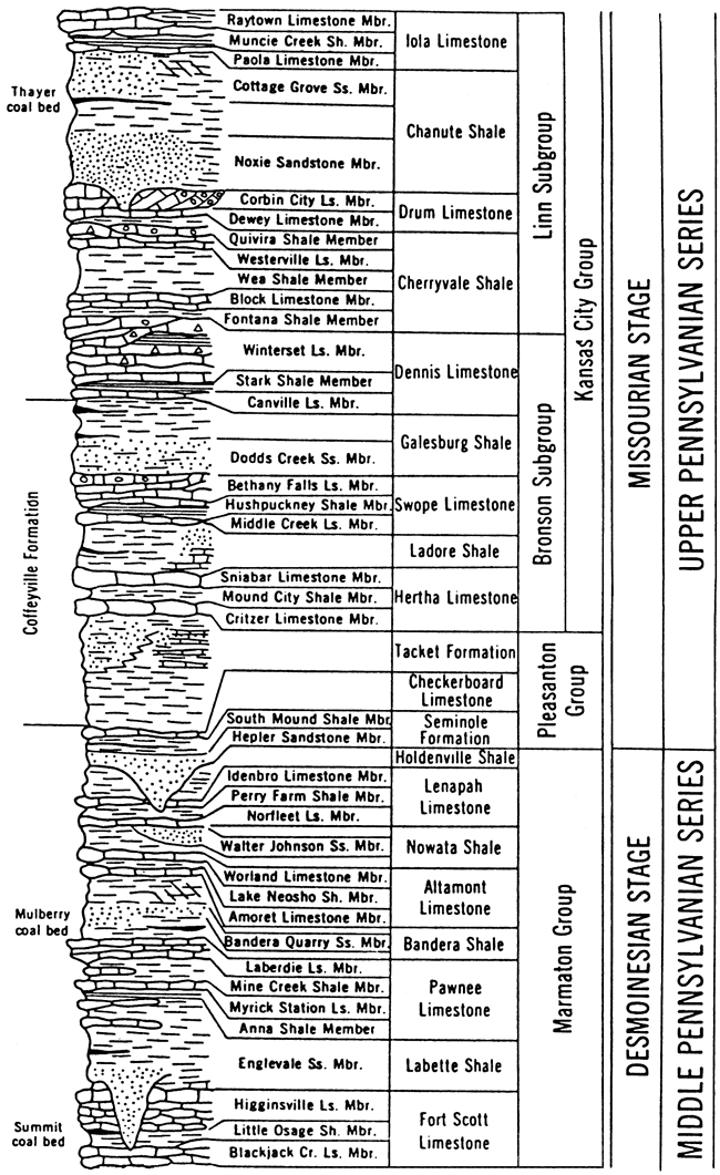
Most of the upper Desmoinesian, Missourian, and lower Virgilian sequence of the midcontinent Middle-Upper Pennsylvanian outcrop belt has been subdivided into an alternation of dominantly marine limestone formations with thin shale members and dominantly terrestrial to nearshore-marine shale formations with coal beds and local sandstone members (fig. 1). This system of subdivision was established by Moore (1936) for the Bronson, Kansas City, and Lansing groups of the Missourian Stage and the Shawnee Group of the Virgilian Stage and was applied by Jewett (1941, 1945) to the Marmaton Group, which forms the top of the Desmoinesian Stage. It has proved to be quite successful in delineating the stratigraphy of those parts of the midcontinent Pennsylvanian because it has been adopted with only minor modifications of nomenclature and correlation over the years by the state geological surveys of Kansas, Missouri, Iowa, and Nebraska [e.g., Moore (1948), Condra (1949), Burchett and Reed (1967), Hershey et al. (1960), Searight and Howe (1961), and Zeller (1968)].
Figure 1--Stratigraphic column of part of Middle and Upper Pennsylvanian sequence in Kansas showing subdivision of most of sequence into alternation of dominantly marine limestone formations with limestone and thin shale members (e.g., Pawnee, Altamont, Swope, Dennis, and Iola Limestones) and dominantly terrestrial to nearshore shale formations with coal beds and sandstone members (e.g., Labette, Bandera, Nowata, Galesburg, and Chanute shales). Subdivision of the Pleasanton Group is currently undergoing revision (Heckel, unpublished), and the Lenapah Limestone does not show the stratigraphic pattern common to most other limestone formations; thus the entire shale-dominated sequence between the Altamont and Hertha Limestones appears anomalous to the general pattern. The Lost Branch Formation and the revised Memorial Shale proposed herein occupy the position of the Holdenville Shale in this column, which shows the previous formal nomenclature for this part of the sequence in Kansas. [Adapted slightly from Zeller (1968, Plate 1).]
Depositional controls
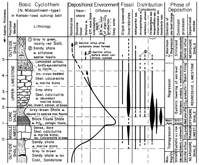
This system of subdivision also has been useful as a stratigraphic framework within which the long-recognized cyclic repetitions of rock units (cyclothems) constituting the formations have been interpreted in terms of an actualistic depositional model [e.g., by Schenk (1967) and Heckel (1977, 1980, 1983, 1984, 1986)]. This model (fig. 2) recognizes cycles of marine inundations, which correspond closely to deposition of the limestone formations, and withdrawals, which correspond closely to deposition of the intervening shale formations.
Figure 2--Basic Depositional Model for vertical sequence of members within limestone formations (middle limestone-core shale-upper limestone) and adjacent parts of shale formations (outside shales). This figure shows the relations between the members of the limestone and shale formations mentioned in fig. I and the phase of deposition during one cycle of marine inundation and withdrawal over the northern midcontinent shelf. Note the high abundance of certain conodont genera, concentrated in offshore (core) shale by sediment starvation during maximum transgression, compared with the sparse conodont faunas dominated by other genera during shallower-water phases of deposition.
The intervening shale formations consist of a variety of rock types deposited at low stands of sea level. Gray to reddish blocky mudstones represent paleosols (Schutter and Heckel, 1985; Goebel et al., 1989; Joeckel, 1989), which are locally overlain by coals. Unfossiliferous sandy shales with local sandstones represent alluvial to deltaic deposits, and sparsely fossiliferous, typically thick and monotonous, silty to sandy shales represent prodeltaic to aggradational muddy shoreline deposits.
Overlying the variable nearshore to terrestrial shale formations is the lowest member of the limestone formations, the transgressive limestone. It is characteristically a thin, dense, dark, skeletal calcilutite with local calcarenitic horizons at the base and represents deposition in deepening marine water.
Above the transgressive limestone is a thin, widespread, sparsely to abundantly fossiliferous, nonsandy, gray to black shale member at the "core" of the limestone formation. This shale typically contains phosphorite nodules and laminae. It also carries an abundant and distinctive fauna of conodonts, dominated by the genera Idiognathodus, Idioprioniodus, Gondolella (in most formations), and Neognathodus (in Desmoinesian formations). This shale represents an offshore-marine shelf environment with very slow sedimentation that resulted in the concentration of the conodonts. It developed at the highest stand of sea level, when the water column became stratified over a large area and inhibited replenishment of bottom oxygen. This stratification led to deposition of the black shale facies and promoted upwelling, which led to deposition of the phosphorite (Heckel, 1977; Kidder, 1985).
The offshore shale is overlain by the thicker upper member of the limestone formation. This unit displays a classic shallowing-upward lithic sequence, ranging from skeletal calcilutite at the base through skeletal calcarenite to locally oolitic and muddy shoreline facies at the top, often with subaerial exposure. This member represents regression of the sea.
Thus each named member recognized by Moore (1936) and later researchers represents a particular phase of deposition corresponding largely to a position of sea-level stand (high or low) or a trend in sea-level change (deepening = transgressive; shallowing = regressive). Heckel (1984) related variations in this basic sequence of members to variation in the extent and rates of transgression or regression of the sea and consequent differences in water depth during highstands, in the position of the shoreline during lowstands, in the encroachment of detrital clastics during regression, and in thickness of the limestone facies formed at intermediate stands. The alternating rises and falls in sea level responsible for this stratigraphic pattern in the midcontinent have been increasingly recognized as eustatic, resulting from periodic waxing and waning of Gondwanan glaciation (Wanless and Shepard, 1936; Heckel, 1984, 1986; Veevers and Powell, 1987), although with autocyclic sedimentary mechanisms, such as delta shifting, which operated wherever the shoreline stood for a sufficient period of time (Wanless, 1967; Heckel, 1980).
Purpose
The only portion of the midcontinent Pennsylvanian succession from the upper Desmoinesian Marmaton Group through the upper Missourian Lansing Group that has not been stratigraphically subdivided in this fashion is the thick shale-dominated sequence that spans the Desmoinesian-Missourian boundary. This includes the Pleasanton Group of Kansas, Missouri, and northward and the Seminole Formation of Oklahoma at the base of the Missourian, and the Holdenville Shale, Lenapah Limestone, and Nowata Shale as currently recognized throughout most of the area at the top of the Desmoinesian Marmaton Group (fig. 1).
Convergence of recent research activities of a number of geologists has contributed greatly to sorting out the detailed stratigraphy of this portion of the sequence. A. P. Bennison of Tulsa, Oklahoma, is working out field relations of lithic units in eastern Oklahoma and adjacent Kansas. W. B. Howe, of the Missouri Geological Survey, is placing in the public domain [e.g., Howe (1982)] the results of his extensive field studies in Missouri, which had been only partly published [e.g., Howe (1953)]. L. R. Wilson, of the Oklahoma Geological Survey, and R. A. Peppers, of the Illinois Geological Survey, are making available the results of their ongoing independent palynologic studies of the coals. D. R. Boardman, currently at Texas Tech University, R. H. Mapes, of Ohio University, and D. M. Work, of the Missouri Geological Survey, are working out the ammonoid sequence, which is represented particularly well in Oklahoma. J. W. Swade (1982, 1985) determined the conodont biostratigraphy of most upper Desmoinesian cycles from two cores in Iowa. Parkinson (1982) and Greenberg (1986) described the stratigraphy and petrology of the Lenapah Limestone from northeastern Oklahoma to northern Missouri and provided details of its conodont fauna that Swade (1982) did not detect in Iowa. My work has involved applying the conodont zonation of Swade (1982, 1985) and more recent findings of other students and colleagues, as well as my own, to the lithic tracing of units along the entire midcontinent outcrop belt. In this work I have utilized cores made available by the Iowa, Nebraska, Missouri, Kansas, Oklahoma, and Illinois geological surveys and studied the field localities either discovered by Howe and Bennison or described in the older literature.
These combined efforts have identified miscorrelations and misuse of names that are not adequately rectified by the currently used stratigraphic nomenclature. The purpose of this report is to begin the more accurate characterization of the stratigraphy of the interval from the top of the Altamont Limestone up into the Missourian Stage along the midcontinent outcrop belt and in the near subsurface, particularly the Forest City basin. This analysis is facilitated by the recognition and the lithic and biostratigraphic correlation of a continuous, distinctive marine horizon at the top of the Marmaton Group and the Desmoinesian Stage, which I propose to call the Lost Branch Formation.
Acknowledgments
I am indebted to the Kansas Geological Survey for long-term field and summer support for this project; to the donors to the Petroleum Research Fund (administered by the American Chemical Society) for support of graduate students J. W. Swade, M. R. Underwood, H. Greenberg, and J. A. Pavlicek; to the Allan and DeLeo Bennison Stratigraphic Research Fund for field and laboratory support; to the Iowa, Nebraska, Kansas, Missouri, Illinois, and Oklahoma geological surveys for access to long cores; and to many members of all surveys for many courtesies extended during this project. Special thanks go to L. A. Hemish of the Oklahoma Survey for directing the drilling and describing the Oklahoma cores; to J. A. French of the Kansas Geological Survey for similar effort on the Kansas Prong Creek core; to R. A. Peppers of the Illinois Survey for providing palynologic data on the age of the coals; to D. R. Boardman and J. E. Barrick of Texas Tech University for sharing information on ammonoid and conodont faunas; to W. B. Howe of the Missouri Geological Survey, J. R. Chaplin of the Oklahoma Geological Survey, A. P. Bennison of Tulsa, Oklahoma, W. L. Watney of the Kansas Geological Survey, and W. L. Manger of Arkansas University for review of various stages of the manuscript; to R. Heidlage of the University of Missouri (Columbia) for providing a thesis copy; and to J. W. Swade (posthumously) for tutoring me in the art of conodont identification. Finally, I dedicate this publication to A. P. Bennison, whose intrepid exploration of the midcontinent outcrop belt to find important new exposures, continual encouragement to all of us working on the outcrop, and generous sharing of data provided a good portion of the effort that made this publication possible.
Editor's note--The stratigraphic nomenclature used in this report is a revised classification for the Desmoinesian through Virgilian strata of the midcontinent. This classification will be outlined in more detail in subsequent reports. The revised classification formalizes and makes consistent most stratigraphic names across the midcontinent states. Other units are still in a state of flux (e.g., Critzer limestone, Exline limestone, Hepler sandstone, South Mound shale, Sasakwa limestone, Eleventh Street limestone) and are treated as informal units.
Prev Page--Contents || Next Page--Previous Nomenclature, New Findings
Kansas Geological Survey, Geology
Placed on web Nov. 2, 2010; originally published 1991.
Comments to webadmin@kgs.ku.edu
The URL for this page is http://www.kgs.ku.edu/Publications/Bulletins/GS4/02_intro.html