![]()
Prev Page--Contents || Next Page--Stratigraphy
Introduction
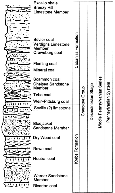
The Cherokee Group (Desmoinesian) in eastern Kansas and northeastern Oklahoma consists predominantly of siliciclastic mudrocks with lesser amounts of lenticular sandstones, thin limestones, and coals. These lithologies occur in repetitive sequences that are exposed in a belt trending southwestward through the study area from western Missouri, through the southeastern corner of Kansas, and through the northeastern portion of Oklahoma (fig. 1). The stratigraphic interval studied consists of the upper portion of the Cherokee between the top of the Verdigris limestone and the base of the Excello shale (fig. 2).
Figure 1--Map of eastern Kansas and adjacent areas showing outcrop belt of Cherokee Group and locations of study areas of University of Iowa master of science students. The years are thesis-completion dates.
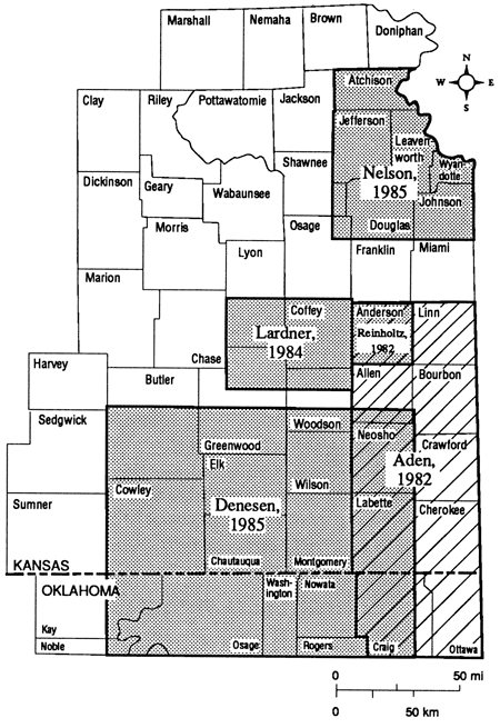
Figure 2--Traditional stratigraphic terms used for Cherokee Group in Kansas; modified from Zeller, 1968.
Purposes of investigation
The purposes of this investigation were to 1) work out the regional stratigraphic relationships within the upper portion of the Cherokee Group, 2) reconstruct the paleogeography of eastern Kansas and adjoining areas during the Desmoinesian, and 3) describe the petrographic characteristics and potential reservoir characteristics of sandstone units within the upper Cherokee.
Tectonic setting and regional structure
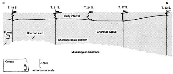
Desmoinesian strata were deposited upon the Cherokee shelf, a tectonically stable depositional platform. The shelf is bounded to the west by the Nemaha uplift, to the east by the Ozark uplift, and to the south by the Arkoma basin (fig. 3). During the Early Pennsylvanian, the shelf was divided into two depositional elements: the Cherokee shelf in southeastern Kansas and northeastern Oklahoma and the Forest City basin in northeastern Kansas, southeastern Nebraska, northwestern Missouri, and southwestern Iowa, separated from each other by the Bourbon arch, a low-relief feature which trends northwest-southeast through east-central Kansas into Missouri (Merriam, 1963). A north-south well-log traverse shows that both the Cherokee shelf and the Forest City basin were filled to such an extent that by the time upper Cherokee sediments were deposited, the Bourbon arch was no longer a depositional barrier (fig. 4).
Figure 3--Pennsylvanian tectonic settings in Kansas and Oklahoma; modified from Lardner, 1984; Merriam, 1963.
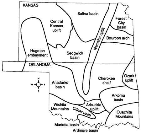
Figure 4--Generalized north-south cross section across Bourbon arch (line N-S on fig. 6), showing thickness variations of Cherokee Group and of upper Cherokee study interval.
The Nemaha uplift is a north-south-trending belt of faulted anticlines which extends from Nebraska to central Oklahoma (McElroy, 1961). Wells and Anderson (1968) suggest that movements along the uplift may have begun as early as late Early Ordovician, but major tectonic movements attained a peak in post-Mississippian, pre-Desmoinesian time, or more specifically, post-Morrowan, pre-Atokan time (Berryhill, 1960).
In Oklahoma, complete burial of the Nemaha uplift was achieved by the beginning of upper Cherokee sedimentation (Krumme, 1981). However, throughout most of its trace in southeastern Kansas, the uplift was a positive feature during the Middle Pennsylvanian, as shown by the onlapping of upper Cherokee beds upon it.
To the east of the Cherokee shelf lies the Ozark uplift, which persisted as a positive feature during the Paleozoic Era. The latest pre-upper Cherokee tectonic movements in the Ozark area seem to have begun prior to deposition of Cabaniss sediments (Branson and Huffman, 1965). Any effect that this uplift might have had on Cherokee sedimentation cannot be determined due to post-Desmoinesian erosion between the study areas and the Ozark uplift.
The regional strike of Desmoinesian strata varies from northeast-southwest along the outcrop belt, to north-south through the center, and northwest-southeast in the southwest corner of the study area (fig. 5) in proximity to the hinge line of the Anadarko basin.
Figure 5--Structure contour map of eastern Kansas from Nemaha uplift eastward.
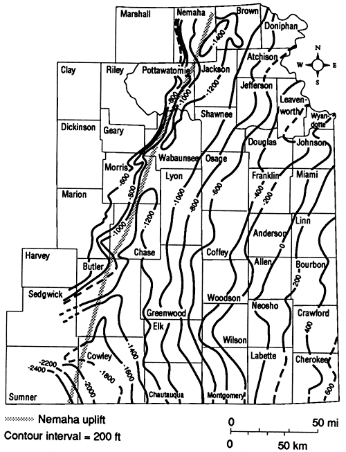
The region forms part of the Prairie Plains homocline, a post-Permian structure (Berryhill, 1960). Beds dip westward at about 3-9 m/km (30-50 ft/mi). Near the Nemaha uplift, the dip changes as beds flatten and then reverse to the east as a result of post-Cherokee tectonic movements along the uplift.
Smith (1955) documented several folds in Cowley County, Kansas, and Kay County, Oklahoma, which trend parallel to the Nemaha uplift. Denesen (1985) reported that evidence for tectonic movements involving the upper portion of the Cherokee was observed in Butler and Cowley counties, Kansas, and Kay, Osage, and Washington counties, Oklahoma. These structures have not as yet been analyzed; however, they appear to have had little influence on Middle Pennsylvanian sedimentation.
Previous work
Although the Cherokee shelf has been subjected to oil exploration over the last 120 yrs, only during the previous 50 years has there been much published information about the nature of Desmoinesian strata. Investigations of these rocks on the surface have been summarized by Howe (1956) for Kansas and Branson and Huffman (1965) for northeastern Oklahoma.
Subsurface studies of Desmoinesian strata in Oklahoma are more numerous than those in Kansas due to a large extent to theses done at the University of Oklahoma. Many of these theses deal with the nature of lenticular sandstones and persistent marker horizons as they relate to the geologic history of the region. These studies include those by Ware (1955), Smith (1955), Graves (1958), Kirk (1958), Querry (1958), Stringer (1958), Baker (1958), Sartin (1958), Berryhill (1960), McElroy (1961), Strong (1961), Clayton (1967), Hanke (1967), Cole (1970), and Scott (1970). In addition, similar theses were done by students from Oklahoma State University and Tulsa University. These authors include Berry (1967), Dogan (1970), Astarita (1975), Candler (1979), and Shipley (1979).
Krumme (1981) examined strata between the base of the Verdigris Limestone Member and the top of the Checkerboard Limestone (Missourian Series) and delineated the paleoenvironment of the shelf by examining the depositional trends and characteristics of limestones, sandstones, and key marker horizons. He also attempted to make correlations between strata on the Cherokee shelf and the Arkoma basin strata.
Very little information about the subsurface stratigraphic nature of the Cherokee Group in southeastern Kansas has been published. Smith (1955) correlated Kansas and Oklahoma strata by the use of electric-log cross sections from Cowley County, Kansas, to Kay County, Oklahoma. Correlations of various prominent Cherokee sandstones were achieved in Bourbon, Cherokee, and Crawford counties by Ebanks and others (1977), and in Greenwood County by Hulse (1978). Woody (1983) and Harris (1984) examined the sedimentology, diagenesis, and petrophysics of sandstones from various intervals within the Cherokee.
To date, the most comprehensive studies of the stratigraphic relationships and depositional environments of prominent lithologies within the upper portion of the Cherokee Group have come from master of science theses at the University of Iowa, in part supported by the Kansas Geological Survey. Sedimentologic and stratigraphic studies include those by Aden (1982), Reinholtz (1982), Lardner (1984), Denesen (1985), and Nelson (1985). The major contributions made in these theses are incorporated into this report.
Methods of study
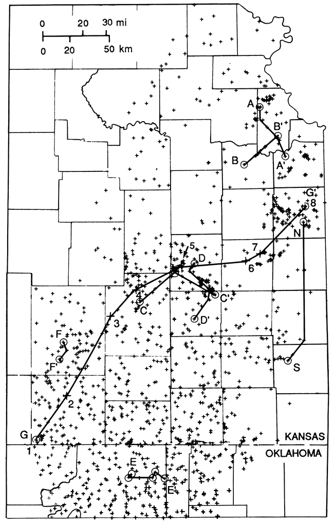
Geophysical well logs from 1,293 wells were examined (fig. 6 and appendix A), mostly from the well-log libraries at the Kansas Geological Survey in Lawrence and the Oklahoma Geological Survey in Norman. Where available, an average density of three well logs per township was used in an attempt to secure adequate representation of strata within the study area. After eliminating logs that did not record data from the interval of study, logs from 1,229 wells were used in this study. Gamma-ray, neutron, and density well logs were used because of their high bed resolution, which facilitates the differentiation of black shales, coals, and gross geometries of sandstone bodies. Electric logs (SP and resistivity) were used where other logs were not available. Bed resolution is not as precise in electric logs as it is in gamma-ray logs.
Figure 6--Distribution of well logs and locations of stratigraphic cross sections in Kansas and Oklahoma; see appendix A for listing of each well.
Acknowledgments
Although I am solely responsible for the interpretations made in this manuscript, many people contributed data and ideas. Much of the data used in this study was collected and analyzed by the following individuals while they were geology graduate students at the University of Iowa: Leon J. Aden, Stephen L. Denesen, James E. Lardner, Murray R. Nelson, and Philip N. Reinholtz. These students also contributed interpretations and ideas that I have cited and freely drawn upon in this manuscript. Professor Philip H. Heckel of the Geology Department of the University of Iowa first rekindled my interest in the Pennsylvanian of the midcontinent. Dr. W. J. Ebanks, formerly the chief of the subsurface division of the Kansas Geological Survey, introduced me to the Cherokee outcrop belt in western Missouri, southeastern Kansas, and northeastern Oklahoma. He also provided me with aid while working in the Kansas Geological Survey facilities in Lawrence. Aid and guidance were continued by Dr. W. Lynn Watney, chief of the Petroleum Research Section of the Kansas Geological Survey, who also reviewed early drafts of this manuscript. I would like also to thank the other individuals who critically reviewed various drafts of this manuscript. Other employees and past employees of the Kansas Geological Survey provided logistical support to my students and me. Professor Anthony W. Walton of the University of Kansas discussed with me observations and interpretations that he and his students made in the lower portion of the Cherokee Group.
Finally, I wish to thank the many landowners, drillers, and loggers that helped my students and me obtain critical pieces of information during the course of our studies.
Prev Page--Contents || Next Page--Stratigraphy
Kansas Geological Survey, Geology
Placed on web Oct. 27, 2010; originally published 1989.
Comments to webadmin@kgs.ku.edu
The URL for this page is http://www.kgs.ku.edu/Publications/Bulletins/GS3/02_intro.html