![]()
![]()
![]()
Prev--Terminal zone of continental glaciation || Next--Remote sensing and geophysical investigations
Kansas Geological Survey, Lawrence, Kansas
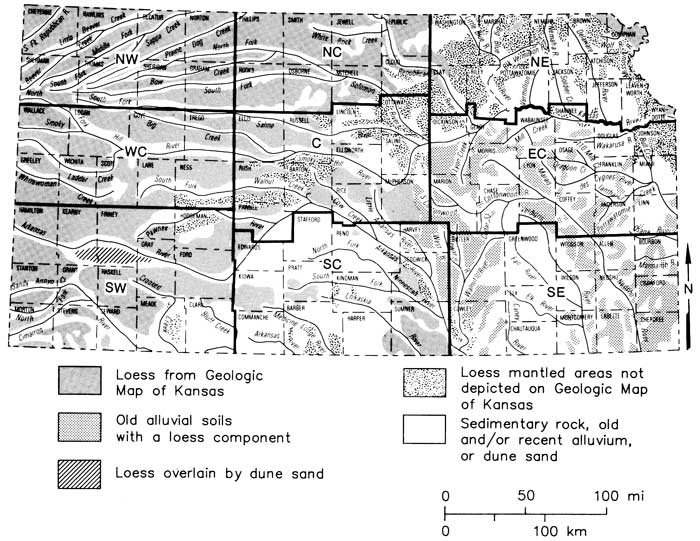
Three major loess units are recognized in Kansas: the Loveland, Peoria, and Bignell formations. These eolian strata were correlated with the glacial succession by Frye and others (1948). Loveland loess is of Illinoian age and Peoria loess is of Wisconsinan age. The age of Bignell loess is in dispute. Some radiocarbon dates place it as late Wisconsinan and others as early Holocene. A new loess-distribution map of Kansas shows that loess comprises about 65% of the surface of the state. Peoria loess is the most exposed and widespread loess in Kansas. Bignell loess is discontinuous and is restricted to central and western Kansas. A statewide systematic study of the thickness of loess in the state has not been attempted. Thickness data for this report were derived from logs of wells and test holes of county geology and hydrology reports. Most of these data are inconsistent and unreliable for a number of reasons. The most abundant and seemingly reliable thickness data on loess in Kansas is that for the northwest and west-central regions where thickness ranges from 100 ft (30 m) in the northwest area to 5 ft (1.5 m) in the southeast area of the two regions. The source of the loess in Kansas has been debated for the last 50 yrs. Three theories have emerged regarding the source of the Peoria loess: 1) glacial (alpine and continental) outwash river floodplains, 2) desert regional sources (areas of sand dunes), and 3) regional fluvial and eolian erosion of the Ogallala Formation. A single-source-area hypothesis does not satisfactorily explain the discontinuity in distribution and variation in thickness of the Peoria loess found in Kansas. We conclude from reviewing loess literature of the past 50 yrs and our generalized loess-distribution map of Kansas that the loess in Kansas was derived from a combination of these three sources. We also conclude that there is not sufficient information available to assess the volume that each source contributed to the total volume of loess deposited in Kansas. The relationship between loess formations and modern soils formed in loess has received little study. We correlated Kansas soils formed in loess with specific loess formations. Several major soils were reported in the literature as having formed in both Peoria and Bignell loess. This contradiction is due to the uncertainty of the areal extent of Bignell loess in Kansas. In eastern Kansas many modern soils formed in old Pleistocene alluvium on broad, flat, upland areas seem to have a loess constituent in their upper profile. Representative profiles of major soils of Kansas developed in loess were sampled by horizon at locations spaced widely around the state. The purpose is to assess the lateral and vertical variation of loess in the state by studying the geochemical variations within and among modern soils formed in the loess. It is hoped that the data acquired will provide answers concerning distribution, multiple sources, and relative ages of loesses in Kansas.
The most comprehensive, most significant, and most recent published information about Pleistocene loess in Kansas is that found in Pleistocene geology of Kansas (Frye and Leonard, 1952). That publication reviewed and summarized then-current knowledge (accumulated from 1937 to 1952) about the Pleistocene geology of Kansas. The authors expressed hope that their publication would serve as a source of general data and as a starting point for future, more detailed and complete studies in Kansas Pleistocene geology. The report has been quite successful as a source of general data. Since its publication, no organized and correlated research has been done on Kansas Pleistocene geology. Frye left the Kansas Geological Survey in 1955, and research on Pleistocene geology in Kansas has since waned. This situation has existed for the most part for a little over 30 yrs.
The purpose of this report is to review, consolidate, update, comment on, and summarize knowledge about Pleistocene loess in Kansas and to serve as a starting point for our research on the trace-element geochemistry of loessal soils. Also we intend the report to assist others in studies of Pleistocene loess in Kansas and the Quaternary Period in general.
Since 1947, three major loess units have been recognized in Kansas: the Loveland, Peoria, and Bignell formations (Frye and Fent, 1947). Loveland loess is the oldest and was named by Shimek (1910). It later was described and classified as loess by Kay and Graham (1943) from exposures along the east bluff of the Missouri River at Loveland, Iowa. Loveland loess at the type section was described by Frye and Leonard (1951) as being 30ft (9 m) of massive, well-sorted fine sand and silt of which the upper 22-24 ft (6.6-7.2m) is leached of calcium carbonate. The lower 6-8 ft (1.8-2.4 m) is unleached and commonly includes stringers and nodules of calcium carbonate. Fossil faunas have been recorded, but the general occurrence of fauna in Loveland loess in Kansas is sparse. The upper leached zone has a distinct pink to red-brown tint as a result of weathering. This zone was considered part of the Sangamon paleosol by Frye and Leonard (1951). In northeastern Kansas the leached unit is thicker and more pronounced compared to western Kansas, where it appears as a thin, reddish, compact soil horizon (Prescott, 1953; Walters, 1956; Bayne, 1956). In the glaciated portion of Kansas, Loveland loess is often found overlying Kansan till but elsewhere, it occurs overlying alluvial silts, sands, and formations and older bedrock deposits.
Peoria loess, younger than the Loveland but older than the Bignell, consists of massive, yellow-tan to buff-colored, well-sorted, calcareous, very fine sands, silts, and clays. The term Peoria was originally proposed as an interglacial-weathering interval (Peorian) in Iowan loess between the Iowan and Wisconsinan glacial stages by Leverett (1898) from exposures in Peoria, Illinois. When the loess proved to be younger than Iowan, it was designated as Peorian loess by Leighton (1931).
Bignell loess, the youngest loess found in Kansas, was named by Schultz and Stout (1945) from exposures along bluffs south of the Platte River near North Platte, Nebraska. It is morphologically similar to the underlying Peoria loess. However, it is generally more friable and less compact than the Peoria (Frye and Leonard, 1951). The only way to distinguish Bignell loess from Peoria loess in the field is by the Brady soil, first described by Schultz and Stout (1948), which stratigraphically separates the two, and by sparse but distinct fauna in the Bignell loess. Because of the strong morphological and major chemical similarities between these two loess units (Frye and Leonard, 1951), the Bignell loess has been speculated to be a product of reworked Peoria loess.
Loveland, Peoria, and Bignell loesses were once included within the Sanborn formation named by Elias (1931) for Pleistocene deposits exposed in Wallace County. In Kansas, these loesses, along with their alluvial equivalents, were assigned the rank of member (Loveland silt member, Peoria silt member, and Bignell silt member) within the Sanborn formation by Frye and others (1948; fig. 1). This nomenclature was used by Frye and Leonard (1952) and continued to be used by the Kansas Geological Survey until 1959 when the Sanborn formation was dropped from the Pleistocene nomenclature of Kansas and the loess members were reassigned as formations (Jewett, 1959). By 1968, the eolian and alluvial phases of the Loveland, Peoria, and Bignell formations had been separated and the Gilman Canyon Formation was recognized (Bayne and O'Connor, 1968; figs. 1 and 2).
Figure 1--Evolution of Late Pleistocene Series classification of Kansas and old- and present-time stratigraphic units.
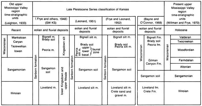
Figure 2--Classification of Pleistocene Series in Kansas (Bayne and O'Connor, 1968).
| Time-stratigraphic units | Rock-stratigraphic units | |||||
|---|---|---|---|---|---|---|
| Northeastern area | Southeastern area | Central and Western area | ||||
| Recent Stage | Eolian and fluvial deposits | |||||
| Wisconsinan Stage | Bignell Formation | Fluvial deposits | Bignell Formation | Fluvial deposits | Bignell Formation | Fluvial deposits |
| Brady Soil | ||||||
| Peoria Formation | Fluvial deposits | Peoria Formation | Fluvial deposits | Peoria Formation | Fluvial deposits | |
| Gilman Canyon Formation | ||||||
| Sangamonian Stage | Sangamon Soil | |||||
| Illinoisan Stage | Loveland Formation | Fluvial deposits | Loveland Formation | Fluvial deposits | Loveland Formation | |
| Crete Formation | ||||||
| Yarmouthian Stage | Yarmouth Soil | |||||
| Kansan Stage | Loess | Fluvial deposits* | Fluvial deposits* | Sappa Formation* | ||
| Cedar Bluffs Till | ||||||
| Fluvial deposits | Grand Island Formation | |||||
| Nickerson Till | ||||||
| Atchison Formation† | ||||||
| Aftonian Stage | Afton Soil | |||||
| Nebraskan Stage | Loess | Fluvial deposits | Fluvial deposits | Fullerton Formation | ||
| Iowa Point Till | ||||||
| David City Formation | Holdrege Formation | |||||
| * Locally contains the Pearlette ash bed. † Atchison Formation has been defined as preglacial outwash of early Kansan age. Similar deposits of sand are found between the Nickerson Till and the Cedar Bluffs Till. |
||||||
Loveland loess in Nebraska and at the type section in Iowa was correlated with equivalent loess deposits in Kansas by Frye and Fent (1947). Frye stated that the Loveland loess was deposited during the waning or retreating phase of the Illinoian Glacial Stage in accordance with his glacial-outwash model of loess origin. However, the presence of minor soils observed within Loveland loess in Kansas (Frye and Leonard, 1954) suggests that the Loveland loess is a complex of loess units in the state. These minor soils which reflect intervals of stability may or may not correlate with the Illinoian substages recognized outside Kansas (fig. 5).
The Wisconsinan Glacial Stage has been subdivided quite precisely as a result of the well-preserved and datable glacial-till deposits within the glaciated portion of the upper Midwest in Illinois. The region along the glacial front is characterized by a complex till stratigraphy created by numerous small- to medium-scale ice advances and retreats. In Illinois, numerous Wisconsinan loess units have been recognized (fig. 3). In northern Illinois the Peoria loess is observed dividing to form two loess units (Morton and Richland loesses) separated by Woodfordian-age tills. Such is not the case in Kansas. Leonard (1951; fig. 1) correlated three distinct faunal zones found in Peoria loess in Kansas with three loess units of the Illinois classification. He correlated a basal zone devoid of faunal fossils with the Farmdale loess (Roxana silt in current Illinois classification), because they had identical molluscan assemblages. A lower faunal zone located above the basal zone was correlated with Iowa loess; an upper faunal zone, separated from the lower faunal zone by a transition zone, was correlated with the Tazewell loess. The lack of any well developed, buried paleosols or other unconformities suggests that Peoria loess in Kansas represents a continuous deposit and the faunal zonation reflects a change in the rate of deposition. Leonard concluded that the Brady soil must have formed in post-Tazewell-pre-Caryan time and the overlying Bignell loess was deposited during Caryan to Mankatoan substages.
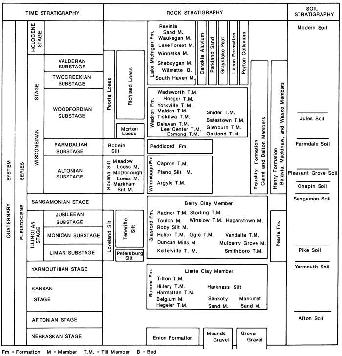
Figure 3--Classification of Pleistocene Series in Illinois (Frye and Willman, 1975),
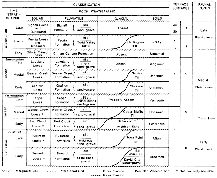
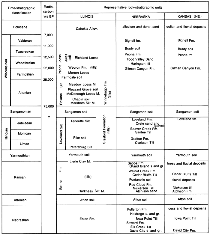
The current Pleistocene classification of Kansas (fig. 2) has not changed substantially from that proposed by Frye and Leonard (1952). Much of the Kansas Pleistocene classification was adopted from the Nebraska Pleistocene classification (fig. 4). The stratigraphic zonations described by Leonard (1951) are not cited in the present Kansas classification, but Peoria loess and Bignell loess were placed within the time frame suggested by Leonard. The use of radiocarbon dating has not been utilized in refining the Wisconsinan loess stratigraphy in Kansas. Dates obtained from similar loess deposits in adjacent states raise questions concerning the placement of the Peoria loess, Brady soil, and Bignell loess within the Wisconsinan time frame. Dreeszen (1970) reported dates of 23,000±600 to 27,900 (+1,100, -1,000) yrs B.P. for the upper 18 inches (46 cm) and 31,400 (+1,800, -1,500) to 34,900 (+2,100, -1,700) yrs B.P. for the lower 18 inches (46 cm) of the basal layer of the Gilman Canyon Formation at the type locality in Nebraska. Rube (1976) reported a date of 24,100±1,650 yrs B.P. for the yrs B.P. in the basal 23 cm (9 inches) of the lower Wisconsinan loess at the Loveland loess type section in Iowa. The basal layer rests on the A horizon of the Sangamon soil. Time-stratigraphically and rock-stratigraphically this basal zone correlates with the Gilman Canyon Formation in Nebraska. The above dates place the start of Missouri River valley loess deposition at mid-Wisconsinan using the Illinois time-stratigraphy classification (figs. 3 and 5), and at early Wisconsinan using the Nebraska time-stratigraphic classification (figs. 4 and 5).
Figure 4--Classification of Pleistocene Series in Nebraska (Reed and Dreeszen, 1965}
Dreeszen (1970) reported dates of 9,160±250 yrs B.P. and 9,750±300 yrs B.P. for the Brady soil at the Bignell loess type location in Nebraska described by Schultz and Stout (1948). Dreeszen acknowledged that the samples were contaminated with rootlets from modern plants. Radiocarbon dates of 12,550±400 yrs B. P. and 12,700±300 yrs B. P. have been obtained from snails in the basal layer of reputed Bignell loess at the Iowa Point section in Doniphan County, Kansas (Frye and others, 1968). Critics have questioned the reliability of snails for dating purposes. Do snails incorporate old carbon from external sources to construct their shells? In the above case, which is more accurate, the soil date or the snail date? The existence of the Bignell loess in northeastern Kansas is in dispute since the presence of the characteristic Brady soil was questioned by Caspall (1972). He concluded that the Brady soil in northeastern Kansas as described by Frye and Leonard (1949) is not a true soil, but rather a weathering zone developed in Peoria loess during a period of slow loess deposition. Excluding the site described by Frye and Leonard (1949), the Brady soil and Bignell loess have not been observed east of the 97th meridian. The general restriction of the two units to west of the 97th meridian requires further study to determine their actual place in the Quaternary classification.
Rube (1976) demonstrated that layers within Peoria loess in western Iowa were time-transgressive. Radiocarbon ages of a buried soil within the loess ranged from 29,000 yrs to 16,500 yrs B.P. among 33 radiocarbon dates. The dates spanned the Farmdalian and half the Woodfordian stages. As a result, the term Peorian loess (Kay and Graham, 1943) was dropped and the loesses in Iowa were reclassified simply as upper and lower Wisconsinan loess (Ruhe, 1954). Analysis of similar layers in Peoria loess in Kansas may produce similar correlation problems. Although relatively short-term migrations of the ice front are significant along the glacial boundary, these events go unrecognized in the unglaciated regions of the Great Plains where direct evidence of glacial movements is absent. Consequently, glacial substages are established from erosion and sedimentation cycles and buried soils (figs. 3 and 4).
The state of Kansas is in a unique geographic position in that Pleistocene loesses and alluvial cycles were related to both continental and alpine glacial events. Alpine glaciers contributed outwash materials by way of the Platte and Arkansas rivers to western portions of the state, and continental glaciers provided similar sediments by way of the Missouri River to eastern Kansas. Local episodes of aggradation and degradation as a result of climate not related to glaciations also must be considered. The loess in western Kansas associated with outwash from the Rocky Mountains may be out of phase with the loess associated with outwash from continental glaciers in eastern Kansas. Although the bulk of the loess deposits in Kansas correlate with the Peoria loess in Illinois, it is time to reevaluate the usage of the term Peoria in Kansas. It has long been recognized that the Peoria loess in Kansas is a complex of several depositions (fig. 5). Additional work is needed to correlate Wisconsinan loesses in Kansas with known sections in Nebraska and Illinois. Any attempt at this time to force-fit apparent subdivisions in the loesses of Kansas into the Illinois section would be inappropriate.
Figure 5--Time-stratigraphic classification (Illinois), radiocarbon yrs B.P. for the Wisconsinan, and representative rock-stratigraphic units in three states; vertical scale is not linear with time.
A map depicting the distribution of Pleistocene (Peoria) loess in Kansas (fig. 6) shows that loess comprises approximately 65% of the present surface of the state as opposed to earlier estimates of 33% by Frye and Leonard (1952) and 50% by Bayne and O'Connor (1968). Areas with a thin, but relatively widespread layer of loess accumulation often are not shown on geologic maps which emphasize bedrock formations. For example, Berry (1952) excluded loess less than 3 ft (.9 m) thick when he prepared the geologic map of Lincoln County. Using modern soil surveys (U.S. Department of Agriculture, Soil Conservation Service), which utilize a 2-ft (.6-m)-thickness minimum for loess, we identified additional areas of loess deposition in Kansas and expanded the areal distribution of loess in the state.
Along the Missouri River in northeast Kansas, Pleistocene loess is quite extensive. Except where dissected by large streams, loess covers the entire upland surface of Doniphan County and most of Wyandotte County. A thick cover of loess forms a nearly continuous band paralleling the river valley in Doniphan, Atchison, Leavenworth, and Wyandotte counties. Loess covers most of the uplands in Leavenworth, Marshall, and Clay counties and large areas of northern Nemaha, eastern Brown, Atchison, northeast Jackson, Jefferson, Riley, and southern Washington counties. The land surface in western Brown County is underlain by Lower Permian rocks. Southwest Leavenworth County is underlain by Upper Pennsylvanian rocks. Areas in Marshall County not covered by loess are mostly covered by Pleistocene glacial drift. Some areas are underlain by Lower Permian rocks. Most of the surface in Washington County not covered by loess is underlain by Lower Cretaceous rocks. In eastern and southeastern Riley County, Lower Permian rocks underlie the surface.
Glacial drift is the dominant surface material in areas of Nemaha County not covered by loess. Where loess is absent in western and south-central Atchison County, glacial drift covers the surface. In the eastern portion of the county, where loess is absent, Upper Pennsylvanian rocks underlie the surface not covered by glacial drift. The majority of western and southern Jackson County is underlain by Lower Permian rocks with the remainder covered by glacial drift. The north-central and central areas of the county are covered predominantly by glacial drift with areas underlain by Lower Permian rocks. In Jefferson County, loess covers the uplands in areas in the northeast, southeast, north-central, and central sections. Glacial drift and Upper Pennsylvanian rocks comprise the surface of the uplands over the rest of the county. In Pottawatomie County, loess is found in the north-central and west-central regions on narrow upland areas. The upland surface of the rest of the county is underlain mostly by Lower Permian rocks with some areas covered by glacial drift.
Relatively narrow and discontinuous deposits of loess occur on the uplands adjacent to the Kansas River in Geary, Riley, Shawnee, Douglas, Leavenworth, Wyandotte, and Johnson counties.
Except for northern and eastern Johnson, northeastern Miami, northern Dickinson, and western Cowley counties, widespread loess deposits have not been recognized in these two areas. However, several soils of the two regions are thought to contain a loess component. Some upland soils formed in limestone have a surface horizon of loess. The Polo soil is an example. Other upland soils such as Dwight, Irwin, Ladysmith, Parsons, Kenoma, and Woodson that formed in old Pleistocene alluvium are suspected of having a surface horizon of loess or of having loess incorporated into the surface horizon.
Dwight, Irwin, and Ladysmith soils formed in old alluvium derived primarily from Lower Permian rocks. In these two regions, Lower Permian rocks crop out west of a line from southwest Chautauqua County at the Oklahoma state line to northwest Shawnee County at the Kansas River. East of this line Pennsylvanian rocks crop out. Kenoma, Parsons, and Woodson soils formed in old alluvium derived primarily from these rocks. The Woodson soil in Douglas County is reported to have formed in loess and old alluvium. Further south in Allen and Anderson counties, the parent material is reported to be just old alluvium. In Woodson County this soil is reported to have formed in loess and loess-contaminated old alluvium. Combining the areas covered by these old alluvial-loessal soils with known loess deposits of the state indicates that the entire state probably was mantled by loess during the late Wisconsinan and early Holocene (fig. 6).
Figure 6--Generalized pleistocene loess-distribution map of Kansas (after Geologic map of Kansas, 1964, Kansas Geological Survey bulletins, and Soil Conservation Service soil surveys).
East of the Republican River valley from northwestern Republic County to the river's confluence with the Smoky Hill River at Junction City in Geary County, a continuous mantle of loess is present on the uplands adjacent to the Republican River. Republic County is almost entirely covered by loess with the best exposures located along the eastern Hanks of the river valley.
West of the valley, loess covers the surface of an extensive plain coextensive with the Carlile Shale formation. In Jewell, Smith, Osborne, Mitchell, and Cloud counties, loess covers the upland surface except where Upper Cretaceous rocks underlie the surface. In Phillips and Rooks counties, loess is the dominant surface material except where the surface is underlain by Upper Cretaceous and Tertiary rocks.
Loess deposits are found on the uplands adjacent to the Saline River in Russell and Lincoln counties. These deposits are more extensive in Russell County. In Ottawa County, loess mantles the uplands east and west of the Solomon River. In Saline County, loess mantles the uplands mostly west of the Smoky Hill River in the north-central, central, and south-central regions. In Ellis and Russell counties, loess occurs on adjacent uplands of both the Saline and Smoky Hill rivers. In Ellsworth County, loess is found on the uplands only in the northwest and southwest portions of the county. In Lincoln and Ellsworth counties loess is absent where Cretaceous rocks underlie the surface. West of the loess deposits in Saline County, Lower Cretaceous rocks underlie the surface while in eastern Saline County, Lower Permian rocks underlie the surface. In northern McPherson County, both Lower Permian and Lower Cretaceous rocks underlie the surface. North of the Arkansas River in Rush, northern Pawnee, and Barton counties; northwest, north-central, northeast, and central Rice County; and most of the southern two-thirds of McPherson County, loess is the dominant surface material. An extensive tract of sand and dunes comprises the land surface south of the Arkansas River in southeast Pawnee, southeast Barton, and southwest Rice counties.
Loess mantles the uplands in Edwards County northwest of the Arkansas River; in northwestern, central, and southwestern Harvey County; central, south-central, west-central, and southwest Kiowa County; and central, south-central, west-central, and southwest Pratt County. Wisconsinan and/or Holocene dune sands and alluvium overlie the upland surface of Stafford County. Old alluvium overlies the surface in the east-central region of the county. Reno County is also overlain predominantly by dune sands and old alluvium. An area of loess has been observed in the east-central and southeast regions of the county. Most of the northern half of Pratt and the northern third of Kiowa counties is overlain by dune sand. Edwards County, east of the Arkansas River, is also overlain predominantly by dune sand. Small but recognizable areas of loess have been delineated in the southeast and south-central areas of Barber County, extreme north-central Comanche County, and extreme east-central Harper County. The majority of the upland surface of Comanche, Barber, and Harper counties is underlain by Upper Permian rocks except in the northern halves of Comanche and Harper counties where old Pleistocene alluvium is the dominant surface material. Most of Kingman County, except in the west-central and central regions, where areas of loess occur, is overlain by old Pleistocene alluvium. Loess mantles the upland surfaces over much of north-central, central, and south-central Sedgwick County. Almost all the uplands in Sumner County, except in the northwest, are overlain by loess. The upland areas of Sedgwick County not covered by loess are covered by old Pleistocene alluvium except in the extreme eastern section where Lower Permian rocks underlie the surface.
In the northwestern region of the state, loess is the dominant upland surface material and forms a nearly continuous mantle over the land. It is absent only where channel erosion has exposed underlying Tertiary rocks.
Loess also forms a nearly continuous mantle over the upland surface in the west-central region. Loess covers nearly all the surface in Wallace, Greeley, Wichita, Scott, Lane, and Ness counties. It is absent only where underlying Tertiary and Upper Cretaceous rocks crop out. In central Logan County and in southern Gove and southern Trego counties, loess is absent and an extensive and wide band of Upper Cretaceous rocks is exposed.
North of the Arkansas River in the north halves of Hamilton, Kearny, Finney, Gray, and Ford counties and in Hodgeman County, loess forms an extensive mantle, being absent only in the alluvial lowlands. In northeast Finney and central and west-central Hodgeman counties where rather large areas of Upper Cretaceous rocks are exposed, loess is absent. Adjacent to the Arkansas River, loess shows some admixing of eolian sand.
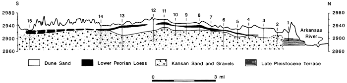
Between the Arkansas and Cimarron rivers from the Colorado state line east across southern Hamilton, southern Kearny, southern Gray, southern Ford, Stanton, Grant, Haskell, northwest and east-central Meade, northeast Seward, and northern Morton counties, loess mantles all the upland surface. The loess is bounded on the north by extensive Holocene and/or Wisconsinan dune sands from the Arkansas River (Frye and Leonard, 1952; Smith, 1940; Simonett, 1960; Madole and others, 1981). In southeast Kearny, southern Finney, and west-central Gray counties, loess has been observed below the dunes. Smith (1940) observed dune sand overlying a thick soil developed in loess along a railroad exposure south of Garden City in Finney County and in a volcanic-ash pit near Fowler in Meade County. Frye and Leonard (1952) observed dune sand overlying Peoria loess in north-central Stanton County. Simonett (1960) analyzed test logs of the dune field south of the Arkansas River near Cimarron in Gray County and found loess underlying the dunes (fig. 7). The dunes taper off at Dodge City in Ford County and then expand into a huge field within the Great Bend area of the Arkansas River in the central and south-central regions in Pawnee, Edwards, Kiowa, Barton, Stafford, Pratt, Rice, and Reno counties.
Figure 7--Geologic cross section of sand dunes and underlying deposits south of Holcomb, Kansas (Simonett, 1960).
South of the Cimarron River in extreme southern Morton; northeast, north-central, and southern Stevens; and southwest Seward counties, areas of loess mantle the surface. In southern Stevens County small and patchy areas of dune sand share the landscape with loess. The remainder of the uplands in these three counties is covered by extensive contiguous areas of dune sand. In Clark County, loess is found only in the extreme northwest corner. Upper Permian rocks underlie the surface and dominate the topography of the rest of the county along with smaller areas of exposed Tertiary rocks and dune sand.
The distribution of loess described on the preceding pages is that of Peoria loess within Kansas. Loveland loess which occurs below the Peoria loess has a widespread distribution as well, but it is discontinuous and patchy as a result of erosion through geologic time. It has been recognized across northern Kansas from the Missouri River in the east to the Colorado state line in the west. The best exposures are located along the major valleys of the Missouri, Republican, and Arkansas rivers. In north-western Kansas, it is recognized locally, although in Sheridan County it is more widespread than in adjacent counties (Bayne, 1956). Massive deposits of Loveland silt have been described occupying an abandoned channel of the Arkansas River in northern Rice County (Fent, 1950). Frye and Leonard (1952) observed Loveland loess in southwestern Kansas in northwest Clark County and southwest Ford County.
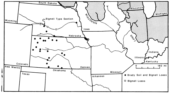
Bignell loess, though described in exposures in Doniphan County (Frye and Leonard, 1949), is probably restricted to central and western Kansas. It is poorly represented in north-central Kansas where it is located on the uplands along the Republican and Solomon rivers. Measured sections of Bignell loess have been observed in northwestern Kansas in Norton, Thomas, Decatur, Sheridan, Rawlins, and Cheyenne counties and in west-central Kansas in Gove, Greeley, Logan, and Wallace counties. Caspall (1970, 1972) stated that measured sections have been observed in southwest and south-central Kansas (fig. 8) where the Bignell had not previously been recognized by Frye and Leonard (1952). Because the Bignell loess is almost impossible to recognize in the field without the Brady soil being present, reliable estimates of its areal distribution are not available.
Figure 8--Locations of measured sections of Bignell loess and Brady soil in Nebraska and Kansas (Caspall, I972).
A long-term statewide systematic study of the thickness of loess in Kansas has not been attempted to date. Frye and associates made a reconnaissance of the state in the 1940's but collected little quantitative data. Most of the information on the thickness of loess for this paper was derived from logs of wells and test holes of county geology and hydrology reports published cooperatively with the U.S. Geological Survey (Kansas Geological Survey, 1941-1974). With the exception of a few authors, the surficial unconsolidated sediments were not differentiated. For some reports, the loess-bearing formations were included with waterlain deposits (terraces and alluvium) of the same age. Therefore, the loess thicknesses given in this report should be used in a general sense. The loess-thickness values used were selected from upland areas so that erroneous measurements due to alluviation were minimized.
Along the Missouri River from Doniphan to Wyandotte counties (fig. 6), loess thickness is in excess of 50 ft (15 m). In Brown County, 86 ft (26 m) and 68 ft (20 m) of Wisconsinan eolian deposits were observed at separate sites (Bayne and Schoewe, 1967). Frye and Leonard (1949) described 75 ft (23 m) of loess overlying till and outwash at Iowa Point in Doniphan County and reported 195ft (59 m) of loess was penetrated by drilling in the northern part of Brown County. In Leavenworth and Wyandotte counties, absolute thickness is not known. The geographic position of Wyandotte County in relation to the Missouri River and predominant wind direction (northwesterly) suggests that deep accumulations of loess exist in the county.
The thickness of loess decreases over a relatively short distance from the Missouri River. In Brown County the average thickness of loess, exclusive of river-bluff deposits, is approximately 10 ft (3 m). Two counties to the west, in Marshall County, the average loess thickness is approximately 8 ft (2 m). A maximum thickness of 20 ft (6 m) was observed in the northern part of Marshall County (Walters, 1954).
Widespread and thick accumulations of loess have not been found in these regions except in Johnson County where 20 ft was measured in the northeastern part of the county (O'Connor, 1971). The loess thins in the county to the south and west where 2-6 ft is common. Thin (less than 10 ft) local deposits of loess occur on the uplands south of the Kansas River in Shawnee County (U.S. Department of Agriculture, 1960-1986) and Douglas County (O'Connor, 1960).
North of the Republican River in northeastern Cloud County as much as 20 ft (6 m) of loess has been observed capping Illinoian terrace deposits. As much as 40 ft (12 m) overlies the Dakota Formation north of Aurora in east-central Cloud County (Bayne and Walters, 1959). In northern Republic County, Fishel (1948) reported as much as 100 ft (30 m) of loess. Fishel's loess also included alluvial sands, silts, and clays which fill an ancient channel of the Republican River. The amount of accumulation of loess deposited on the valley fill is not known, although Fishel estimates as much as 20-30 ft (6-9 m) of Peoria loess overlies a paleosol.
In the area drained by the Arkansas River, thicknesses of loess are vague. Fent (1950) and Latta (1950) reported over 50 ft (15 m) of Loveland and Peorian silts north of the Arkansas River in eastern Barton and western Rice counties. Frye and Leonard (1952) suggested that these estimates were too high for loess and most of the deposits represented alluvial filling of the buried Chase channel preceding deposition of loess during Illinoian time. Test-hole records indicated Peoria loess to have a maximum thickness of 20 ft (6 m) in the area. In Cowley County, Bayne (1962) reported a maximum of 33 ft (10 m) of eolian silt deposits on the upland divide separating the Arkansas and Walnut rivers north of Arkansas City.
The most abundant and seemingly reliable data available on loess thickness in Kansas is that for the northwest and west-central regions with the exception of Thomas, Scott, Lane, and Ness counties where no reliable thickness values are available. The thickness of loess in these two regions ranges from 10 to 25 ft (3-8 m) in Norton, Graham, and Sheridan counties in the northeast and Wallace, Logan, Greeley, and Wichita counties in the southwest. In Gove and Trego counties in the southeast, loess thins to 5-10 ft (1-3 m) in thickness. In the northwest, loess thickness is greatest, ranging from 20 to 40 ft (6-12 m) in Sherman County, 25-60 ft (8-18 m) in Rawlins County, and 25-100 ft (8-30 m) in Cheyenne County. In western Rawlins and eastern Cheyenne counties between McDonald and Wheeler, loess thickness ranged from 79 to 132 ft (24-40 m) with an average of 101 ft (31 m; Prescott, 1952).
These data show a thinning of the loess in northwest and west-central Kansas to the east, southeast, and south which substantiates similar observations by Swineford and Frye (1951).
Little information exists regarding the thickness of loess in southwestern Kansas. Smith (1940) estimated the thickness of loess to range from a few feet to several tens of feet. Smith observed good exposures in southern Ford County where he measured 50 ft (15 m) of loess along Mulberry Creek.
Loess deposition requires 1) a renewable source of silt, 2) wind blowing dominantly from one direction, and 3) a location for deposition to occur (Bryan, 1945). In the central Great Plains, the dominant winds are northwesterly. The form and structure of eolian deposits suggest that the wind direction has not significantly changed from that during the Wisconsinan (Ahlbrandt and Fryberger, 1980; Swineford and Frye, 1951; and Lugn, 1968). The environment during the Wisconsinan favored widespread eolian transportation and accumulation of loess. The relatively Hat topography of the Plains allowed for long-distant dispersal of silts and clay-sized particles. The Plains paleovegetation was sufficient to inhibit major removal of loess subsequent to deposition. Interpretation of the Wisconsinan vegetation varies from a grassland with riparian forests not unlike the present (Leonard and Frye, 1954), to a boreal-coniferous forest in northeastern Kansas (Gruger, 1973), and in the Sand Hills of Nebraska (Bradbury, 1980), to mixed coniferous-deciduous forests in the floodplains with aspen groveland and extensive grassland prairies on the uplands (Jaumann and others, 1986).
The source of the loess in Kansas has been debated for the last 50 yrs. Research has focused on Peoria loess because of its widespread distribution, great thickness, and its surficial position on the landscape. Loveland loess also is widespread, but discontinuous and visible only where it crops out. The source history of Loveland loess in Kansas is probably similar to that of Peoria loess. Bignell loess seems to be restricted to central and western Kansas, southern Nebraska, and eastern Colorado. Its extent, continuity, and age have not been established. Recent evidence by Sorenson and Schmit (1985) indicate the presence of a Holocene-age loess (Bignell?) along the Missouri River in east-central Missouri. The apparent restriction of Bignell loess to west of 97° longitude precludes a direct relationship with continental glacial activity. A glacial-outwash source for Bignell loess could have been the alpine glaciers of the Rocky Mountains. If the Bignell loess is of Holocene age, it may be genetically and climatically related to the huge sand-dune fields in central and western Nebraska and northeastern Colorado.
Three theories have emerged regarding the source of Peoria loess in Kansas: 1) glacial (alpine and continental)-outwash river floodplains, 2) desert regional sources (areas of sand dunes), and 3) regional fluvial and eolian erosion of the Ogallala Formation.
A glacial-outwash loess source was proposed by Frye and Leonard (1952) at the Kansas Geological Survey as a result of work done during the late 1930's and 1940's. The principal glacial-outwash streams recognized were the Missouri, the Platte, and the Arkansas rivers. The Missouri River was the principal source for the loess deposited in northeastern Kansas. The Platte River served as the principal source of loess in north-central, central, and western Kansas. The Arkansas River was considered by Frye to have contributed only coarse materials locally to areas adjacent to its channel in southwestern and south-central Kansas. Swineford and Frye (1951) added that the Republican and Arikaree rivers served as important local supplemental sources of loess in Kansas, but other major streams in Kansas (Big Blue, Smoky Hill, and Solomon rivers) were concluded not to be contributors of loess.
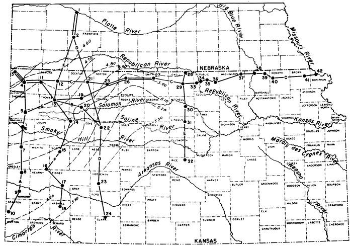
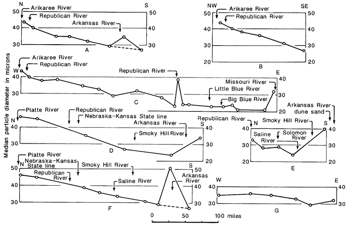
The interpretations by Frye and his coworkers were based on a series of sampling traverses of northeast, north-central, and northwest Kansas; north-central and central Kansas; and southwest Nebraska, northwest, west-central, and southwest Kansas (fig. 9). Peoria loess was sampled for particle-size distribution, major element concentrations, and mineral content. Their conclusions were based on textural variations across each traverse and from minor geographic chemical differences. Median particle size of Peoria loess decreased southward and eastward from points near the Platte, Arikaree, and Republican rivers. The chemical and petrographic data suggested a relatively high degree of chemical uniformity within Peorian loess. Minor geographic differences included higher percentages of dolomite and chert in some northeastern Kansas samples and a higher percentage of calcite in western Kansas samples.
Figure 9--Map of Kansas and southern Nebraska showing sites of Peoria loess sampled by Swineford and Frye (1951). Dashed lines show generalized equivalence of Phi median diameter.
A desert regional source area for Peoria loess was postulated by Lugn (1968). Lugn formulated his hypothesis from his observations of the widespread eolian erosion (dust storms) that typified the 1930's. Based on textural evidence, Lugn concluded that the Sand Hills of Nebraska were the source area for Peoria loess. Lugn considered the Sand Hills to represent the remains of the surficial Ogallala Formation after winds had directly carried away the silts and the clays. From particle-size data, he concluded that the loess source was north of the Platte River in the Sand Hills, and that loess contributions from the outwash-carrying streams like the Platte, Republican, and Missouri rivers were supplemental and only contributed to loess accumulations near the rivers.
Data from recent paleoenvironmental investigations of the Sand Hills in the central Great Plains and their adjacent regions dispute Lugn's premise of a desert environment. Faunal fossils have been found in north-central Kansas and southern Nebraska that suggest a boreal climate persisted during the Wisconsinan Stage (Stewart, 1978; Corner, 1977; Hoffman and Jones, 1970). Bradbury (1980) found evidence that a boreal-coniferous forest occupied the entire Nebraska Sand Hills region.
Lugn's premise that the Nebraska Sand Hills and Peoria loess are contemporaneous appears in doubt as well. Muhs (1985), Ahlbrandt and Fryberger (1980), and Ahlbrandt and others (1983) have dated organic sediments and macrofossils beneath dune sands in Colorado, Wyoming, and Nebraska that show an early Holocene age for the major dune formations. A maximum date of 9,930±140 yrs B. P. was obtained from organic-rich sands underlying eolian sands in the southwestern Nebraska Sand Hills (Ahlbrandt and others, 1983). These dates have not been universally accepted.
Lugn's notion that the Sand Hills were a source for loess may indeed be correct, but not as he envisioned. Silts and clays originally deposited with the sand of the Nebraska Sand Hills may have been removed and deposited elsewhere. If the above dates are accurate, it is possible that the Bignell loess is of Holocene age and is genetically related to the Nebraska Sand Hills deposition instead of the Peoria loess.
The last theory favors a fluvial and eolian source for Peoria loess. From data on test holes through Nebraska Sand Hills sediments, Reed and Dreeszen (1965) postulated that the Ogallala Formation, prior to the Wisconsinan glaciation, was eroded into a hill and valley landscape. The main valleys were filled with sediments grading upward from coarse to fine. During the middle and late Wisconsinan, these sediments were reworked by eolian processes. The silt fraction was blown out regionally to the southeast and the coarse sand blown up where it accumulated locally as dunes. Their theory differs from Lugn's only in the origin of the Sand Hills. They agree with him that the Sand Hills area was a regional source for loess in eastern Nebraska and northern Kansas.
A single-source-area hypothesis does not satisfactorily explain the discontinuity in distribution and the variation in thickness of the Peoria loess found in Kansas. From data on loess thickness in northeastern Kansas, it is apparent that the Missouri River was the principal source for Peoria loess. The great thickness of loess adjacent to the Missouri River in Kansas, Missouri, Iowa, and Nebraska and its decrease in thickness and particle size with distance away from the river valley is strong evidence for the river as a major loess source.
The source of loess in central and western Kansas is not so readily apparent. The conclusions made by Swineford and Frye (1951) were based on a relatively small number of samples. Forty-two sites covering 80,000 mi2 (128,000 km2) were sampled for textural data. Only seven locations were selected for mineral and chemical analyses. It was erroneous of them to conclude that the minor rivers in western and northern Kansas such as Smoky Hill, Saline, Solomon, Big Blue, and Little Blue were insignificant contributors to loess production based on one or two data points near their respective channels. Additionally, the chemical variability of loess cannot be determined from such a small number of samples. If mineral differences exist regionally as indicated by Swineford and Frye (1951), then chemical differences should also exist. Unfortunately, substantial and reliable chemical data on Kansas loesses have not been collected.
The Platte River undoubtedly contributed massive quantities of loess during glacial stages as reasoned by Swineford and Frye (1951). In addition, nonglacial rivers in western Kansas and Nebraska probably contributed substantially more to the volume of loess in the area than previously suspected. Local loess deposits in excess of 75 ft (23 m) have been measured along the southeastern bluffs of the Arikaree and Republican rivers (Swineford and Frye, 1951; Prescott, 1952; and Weist, 1964). The role of these rivers was not completely explained by Swineford and Frye (1951). These rivers were not under the direct influence of Rocky Mountain glaciation as stated by Leonard (1951); their headwaters are in eastern Colorado.
Swineford and Frye (1951) concluded that the Arkansas River carried too sandy a sediment load to act as a major loess source. They suggested that most of the loess deposited south of the Arkansas River in southwest Kansas was derived from northern sources. Swineford and Frye's conclusions were based on two loess samples south of the river which had median grain sizes progressively smaller than samples along a traverse north of the river (fig. 10). Samples taken adjacent to the Arkansas River were much coarser. Not mentioned was a third sample taken south of the river which would have shown an increase in median grain size of the loess (sample 24, Clark County). Three samples seem insufficient for making any significant interpretations regarding the source of loess for the whole southwestern area of Kansas. The loess deposits south of the Arkansas River from the Colorado state line eastward to Cowley County in south-central Kansas have not been studied in any detail.
Figure 10--Textural traverses of Peoria loess in Nebraska and Kansas (Swineford and Frye, 1951). Letters correspond to lettered traverses in fig. 9.
As a result of reviewing loess literature of the past 50 yrs on sources of loess in the central Great Plains and our generalized loess-distribution map of Kansas (fig. 6), we conclude that loess in northwest, north-central, west-central, central, southwest, and south-central Kansas was derived from regional sand-dune areas in central and western Nebraska (Sand Hills area) and southwest Nebraska, eastern Colorado, and southwest and south-central Kansas; from alpine glacial-outwash sediments of the floodplains of the Platte and Arkansas rivers; and from floodplain sediments of nonglacial rivers such as the Arikaree, Republican, Solomon, Saline, Smoky Hill, Pawnee, and Cimarron.
East of the Republican River in north-central Kansas and in northeast Kansas, we conclude loess was derived regionally from the Sand Hills area of Nebraska, from continental glacial-outwash sediments in southeast Nebraska and north-east Kansas, and from floodplain sediments of nonglacial rivers such as the Big Blue, Little Blue, and Delaware.
In northeast Kansas along the Missouri River, we conclude loess was derived from continental glacial-outwash sediment in the floodplain of the river.
Lastly, we conclude that there is not sufficient information available to assess the volume that each loess source contributed to the total volume of loess deposited in the state.
The erosion and subsequent sedimentation of the Ogallala Formation in response to the fluctuating climate during the Pleistocene has not been adequately evaluated. Reed and Dreeszen (1965) alluded to this in postulating a regional source for loess in Nebraska. Other large rivers draining the Ogallala sediments such as the Arikaree, Republican, Solomon, Saline, Smoky Hill, and Pawnee may have contributed loess. Thin but recognizable loess deposits occur adjacent to the Solomon River in Ottawa County and adjacent to the Saline River in Ellis, Russell, and Lincoln counties (U.S. Department of Agriculture, 1960-1986).
For east-central Kansas, we believe that a thin loess mantle existed during the late Wisconsinan. Discontinuous but recognizable loess deposits occur adjacent to the Kansas River from Rossville in Shawnee County to Kansas City in Wyandotte County. This loess probably could not originate from a source other than the Kansas River valley. Since the Kansas River was not a continental glacial-outwash river during the late Pleistocene as it was during the early Pleistocene, the loess probably was derived from erosion of upper loess deposits within the drainage basin. The loess blanketing Johnson and northern Miami counties probably was derived from the Missouri River; however, the Kansas River cannot be ruled out as a source.
The suspected loess-related deposits in central and southeast Kansas also probably had multiple sources. The Kansas-Republican river system might have been a source. The Marais des Cygnes, Verdigris, and Cottonwood-Neosho rivers flowing southeastward through the area likely were loess sources. Strong and persistent south winds that typically occur during the summer may have been of sufficient duration to transport loess from the Arkansas River valley. Total accumulations within the region are difficult to determine because little if any loess persists today as a recognizable unit. The rate of erosion evidently exceeded the rate of loess deposition or the rate of deposition equaled the rate of soil formation. The loess is incorporated in surface horizons of modern soils formed in old Pleistocene alluvium on broad, flat, upland areas. The age of these loess deposits is difficult to determine. The loess may be the result of more recent processes of deposition during the Holocene.
As a result of time, rate of deposition, multiple sources, and distance from sources, loess forms a complex blanket on the Kansas landscape. The relationships between loess thickness and texture to distance from a source have been described quantitatively by several authors (Frazee and others, 1970; Handy, 1976; Simonson and Hutton, 1954). As distance from a loess source increases, the loess deposit becomes thinner and more finely textured. The rate of loess deposition decreases with distance from a source due to differential settlement of particles within the loess. The greatest rate of loess deposition occurs adjacent to the source area.
These relationships are a major influence in the distribution of modern loess-derived soils. In northeastern Kansas, northwestern Missouri, and southwestern Iowa, soils developed in Peoria loess form narrow bands paralleling the Missouri River (Hanna and Bidwell, 1955; Hutton, 1947, 1950; Springer, 1948). The soils farthest from the river show the greatest degree of weathering and soils nearest the river exhibit the least amount of weathering. Hanna and Bidwell (1955) studied soils along a traverse perpendicular to the Missouri River in Brown County, Kansas, and found that the difference in the amount of clay between the alluvial (B) and parent-material (C) horizons was maximum in the Grundy soil sampled 24 mi (38 km) from the river and was minimum in the Monona soil sampled 2 mi (3 km) from the river. Other trends the authors observed with increasing distance from the Missouri River were 1) a decrease in pH, 2) an increase in organic matter, and 3) an increase in the ratio of sand in the surface A horizon to sand in the C horizon.
Springer (1948) studied the Hamburg, Knox, Marshall, and Sharpsburg soils. The Hamburg soil, located on hilly terrain along the Missouri River bluffs, has the least development (no B horizon) and is calcareous throughout the profile. The Knox, Marshall, and Sharpsburg are more weathered than the Hamburg soil and showed about the same degree of development. The soils were sampled within 9 mi (14 km) of the river. Hutton (1947, 1950) examined the physical and chemical composition of loess-derived soils in southwestern Iowa to determine weathering relationships in soils formed in Peoria loess. He concluded the texture of the parent material and the rate of loess deposition were the dominant soil-forming factors that explained the increase in the degree of weathering for the Monona-Sharpsburg-Seymour chronostratigraphic-lithostratigraphic sequence. The Monona silt loam, developed in loess 500-700 inches (1,250-1,750 cm) thick, is the youngest soil morphologically. It contains more sand and coarse silt throughout its profile than the Sharpsburg and Seymour soils. The Seymour silty clay loam is the oldest soil morphologically. It developed in loess 100 inches (250 cm) thick and contains more clay throughout its profile than both the Monona and Sharpsburg soils. The Sharpsburg silty clay loam developed in loess 150-250 inches (375-625 cm) thick. It is texturally similar to the Seymour soil but contains less clay in its profile. The Monona, Sharpsburg, and Seymour soils were sampled 20-40 mi (32-64 km), 90-100 mi (144-160 km), and 160-170 mi (256-425 km) from the Missouri River, respectively. Hutton concluded that within 50-60 mi (125-150 km) of the loess source, the nature of the parent material was the dominant soil-forming factor. Beyond 60 mi (150 km), the rate ofloess deposition was the dominant soil-forming factor. At this distance the rate of loess deposition approached the rate of weathering and the two processes operated concurrently.
The relationship between loess formations and modern soils formed in loess has received little study. In locations where the Loveland, Peoria, and Bignell loesses are present together, it is not uncommon for all three to be exposed along sloping terrain. Kansas soils mentioned in the literature as having been developed in a particular loess are given in table 1. Ruhe (1984) suggested that the changes in clay parameters along a transect from eastern Iowa to northwestern Kansas were due to a change in loess type from Peoria loess east of the Missouri River to Bignell loess west of the river. According to Ruhe, the Harney and Holdrege and Keith and Ulysses soils of Kansas developed in Bignell loess. These soils are the most widely occurring loess soils in central and western Kansas, respectively. The distribution of the Bignell loess may not be that extensive. Several exposures of Peoria loess have been mapped Holdrege, Harney, Keith, or Ulysses in the soil surveys. This contradiction is due to the uncertainty of the areal extent of Bignell loess in Kansas because of its apparent chemical and physical similarity to Peoria loess. Morphologically the Bignell loess can only be distinguished from the Peoria loess by the presence of the Brady paleosol. The Kuma soil of eastern Colorado contains a well developed buried soil that is over 30 inches (76 cm) thick and probably correlates with the Brady paleosol. In Kansas, the Kuma soil contains a weak buried soil 13 inches (33 cm) thick that may correlate with the Brady paleosol. Other loess-derived soils such as the Holdrege, Harney, Keith, and Ulysses typically do not contain buried soils within their profiles.
Table 1--Association of modern soils and Pleistocene loess formations in Kansas.
| Soil | Loess formation | County | Source |
|---|---|---|---|
| Butler | Peoria | Republic | soil survey |
| Colby | Peoria | Grant and Logan | soil surveys; Paliwal and others, 1964 |
| Coly | Peoria | Ness and Norton | soil surveys |
| Crete | Peoria | Barton, McPherson, Ottawa, Rice, and Russell | soil surveys |
| Geary | Loveland | Barton, McPherson, Rice, Riley, and Russell | soil surveys |
| Jewell | Fishel and Leonard, 1955; soil survey | ||
| Grundy | Peoria | Jefferson and Leavenworth | soil surveys |
| Brown | Bayne and Schoewe, 1967; soil survey | ||
| Gymer | Loveland | Douglas, Jefferson, and Leavenworth | soil surveys |
| Haig | Peoria | Leavenworth | soil survey |
| Hamburg | Bignell | Doniphan | Frye and Leonard, 1949 |
| Harney | Bignell | all locations | Ruhe, 1984 |
| Lane | soil survey | ||
| Peoria | Jewell | Fishel and Leonard, 1955; soil survey | |
| Barton, Ellis, Hodgeman, Ottawa, Rush, and Russell | soil surveys | ||
| Hastings | Peoria | Republic | soil survey |
| Cloud | Bayne and Walters, 1959; soil survey | ||
| Holdrege | Bignell | all locations | Ruhe, 1984 |
| Norton | Frye and Fent, 1947; soil survey | ||
| Peoria | Norton | Frye and Fent, 1947; soil survey | |
| Graham | Prescott, 1955; soil survey | ||
| Jewell | Fishel and Leonard, 1955; soil survey | ||
| Keith | Bignell | all locations | Ruhe, 1984 |
| Sheridan | Bayne, 1956; soil survey | ||
| Peoria | Logan | soil survey | |
| Sheridan | Bayne, 1956; soil survey | ||
| Kenesaw | Peoria | Republic and Riley | soil surveys |
| Marshall | Peoria | Leavenworth | soil survey |
| Monona | Peoria | Doniphan | Frye and Leonard, A. B., 1949; soil survey |
| Nuckolls | Loveland | Jewell, Russell, and Smith | soil surveys |
| Richfield | Peoria | Grant, Haskell, and Hodgeman | soil surveys |
| Sharpsburg | Peoria | Douglas, Leavenworth, and Shawnee | soil surveys |
| Smolan | Loveland | McPherson, Rice, and Riley | soil surveys |
| Spearville | Peoria | Haskell and Hodgeman | soil surveys |
| Uly | Peoria | Norton | Frye and Leonard, A. B., 1949; soil survey |
| Graham | Prescott, 1955; soil survey | ||
| Barton, Clark, Ness, and Smith | soil surveys |
In east-central and southeast Kansas, many modern soils formed in old Pleistocene alluvium seem to have a loess constituent in their upper profile (fig. 6). The source and age of the loess component is unknown, although much of the contamination of surface horizons may have occurred during Recent (Holocene) time.
The major reason for reviewing the nature of loess in Kansas was to acquire background information for a study on the spatial variations of loess in Kansas by studying the geochemistry of modern soils formed in loess. Earlier chemical analyses of loess in Kansas (Frye and Fent, 1947; Frye and others, 1949; Swineford and Frye, 1951) included only major elements (Ca, Mg, Na, K) which occur naturally in large amounts. Sampling was not random and was not based on a statistical design and a test for significance. A multi-element study examining trace-element (As, Cd, Co, Cr, Cu, Pb, Ni, Se, and Zn) concentrations and distributions in soils formed in loess is in progress at the Kansas Geological Survey (Welch and Hale, 1985). Representative profiles of major soils of Kansas developed in loess were sampled by horizon. Sample locations spaced widely around the state were randomly selected. We hope that the data from this preliminary statistical and systematic analysis of loessal soils in Kansas will provide some answers concerning distribution, multiple sources, and relative ages of loesses in Kansas.
Examination of several trace elements on a horizon-by-horizon basis may also provide evidence of the effects of secondary local processes such as weathering, reworking by wind and water, and mixing of loess with other materials on loess deposits. The Ulysses series just north of the Arkansas River in western Kansas generally has a coarser textured surface (A) horizon than that found in the surface (A) horizon of the Ulysses series further north. This is thought to be from contamination by sand from the Arkansas River floodplain and adjacent dunes.
Modern soil surveys with soil maps based on intensive field sampling and observations have increased our knowledge of the areal distribution of loess in Kansas. However, more data for better control on loess thickness and distribution on a formation basis are needed. Nearly all the available loess-thickness data for Kansas is entombed in drill logs of county geology and hydrology reports. Most of these data are inconsistent and unreliable for a number of reasons. Acquisition of reliable thickness data on a systematic basis is needed to better understand the vertical and lateral variability of loess units. Data on lateral variability of thickness would better delineate source areas of Kansas loess. Data on vertical variability would allow more precise division of Peoria loess.
Radiocarbon dates of Kansas loesses are needed. Dating would allow better correlation of Kansas loess stratigraphy with that of adjacent states and would assist in deciphering between Bignell and Peoria loesses, especially where the Brady soil does not exist. Dating could better delineate the extent of the Bignell loess in Kansas and could assist in determining whether the Bignell loess is Wisconsinan or Holocene in age. Dating may lead to the discovery of Holocene-age loesses in Kansas younger than the Bignell. Loess deposition is occurring in the present, although not at the rate as during the late Wisconsinan and early Holocene.
For almost 35 yrs, research on Kansas Pleistocene geology has been all but nonexistent in Kansas. This report shows there is need for such research. However, due to lack of interest, lack of funding, and the perception of the work by some as basic data gathering, we feel little progress will be made in Kansas in this important area of geology. Similar considerations and perceptions were discussed 24 yrs ago in a symposium paper presented before the geology section of the Kansas Academy of Science.
Two-thirds of Kansas is covered by loess and modern soils have developed in the surface of these loesses where they can be sampled easily and inexpensively. These soils should be studied and analyzed as a starting point for renewed studies on Kansas loesses. A quantitative and statistical trace-element geochemical study of loessal soils could provide, in addition to geochemical identification of loesses, information on the distribution of loess formations, location of source areas, and effect(s) of local processes on distribution.
The manuscript was reviewed by Curtis J. Sorenson, Associate Professor of Geography, University of Kansas, Lawrence; Harold P. Dickey, Regional Soil Scientist (retired), Soil Conservation Service, U. S. Department of Agriculture; and Wakefield Dort, Professor of Geology, University of Kansas, Lawrence. Their comments and suggestions improved the document. Esther L. Price, secretary/word processor, geophysics and geochemistry section, Kansas Geological Survey, ably typed and structured the manuscript through several revisions. Marla Adkins-Heljeson, editor, Kansas Geological Survey, reviewed the manuscript for grammatical errors and edited it to ensure the manuscript followed the guidelines and met the publication standards of the Kansas Geological Survey.
Ahlbrandt, T. S., and Fryberger, S. G., 1980, Eolian deposits in the Nebraska Sand Hills: U.S. Geological Survey, Professional Paper 1120-A, 24 p.
Ahlbrandt, T. S., Swinehart, J. B.. and Maroney, D. G., 1983, The dynamic Holocene dune fields of the Great Plains and Rocky Mountain basins, USA; in, Eolian Sediments and Processes, M. E. Brookfield and T. S. Ahlbrandt, eds.: Elsevier, Amsterdam, p. 379-406.
Bayne, C. K., 1956, Geology and ground-water resources of Sheridan County, Kansas: Kansas Geological Survey, Bulletin 116, 94 p. [available online]
Bayne, C. K., 1962, Geology and ground-water resources of Cowley County, Kansas: Kansas Geological Survey, Bulletin 158, 219 p. [available online]
Bayne, C. K., and O'Connor, H. G., 1968. Quaternary System; in, The Stratigraphic Succession in Kansas. D. E. Zeller, ed.: Kansas Geological Survey, Bulletin 189, p. 59-67. [available online]
Bayne, C. K., and Schoewe, W. H., 1967, Geology and ground-water resources of Brown County, Kansas: Kansas Geological Survey, Bulletin 186, 68 p. [available online]
Bayne, C. K., and Walters, K. L., 1959, Geology and ground-water resources of Cloud County, Kansas: Kansas Geological Survey, Bulletin 139, 144 p. [available online]
Berry, D., 1952, Geology and ground-water resources of Lincoln County, Kansas: Kansas Geological Survey, Bulletin 95, 96 p. [available online]
Bradbury, J. P., 1980, Late Quaternary vegetation history of the Central Great Plains and its relationship to eolian processes in the Nebraska Sand Hills: U.S. Geological Survey, Professional Paper 1120-C, 8 p.
Bryan, K., 1945, Glacial versus desert origin of loess: American Journal of Science, v. 243, p. 245-248.
Caspall, F. C., 1970, The spatial and temporal variations in loess deposition in northeastern Kansas: Ph.D. dissertation, University of Kansas, Lawrence, 294 p.
Caspall, F. C., 1972, A note on the origin of the Brady paleosol in northeastern Kansas: Proceedings of the Association of American Geographers, v. 4, p. 19-24.
Corner, R. G., 1977, A late Pleistocene-Holocene vertebrate fauna from Red Willow County. Nebraska: Nebraska Academy of Science, Transactions, v. 4, p. 77-93.
Dreeszen, V. H., 1970, The stratigraphic framework of Pleistocene glacial and periglacial deposits in the Central Plains; in, Pleistocene and Recent Environments of the Central Great Plains. W. Dort, Jr., and J. K. Jones, Jr., eds.: University Press of Kansas, Lawrence, Department of Geology Special Publication 3, p. 9-22.
Elias, M. K., 1931, The geology of Wallace County, Kansas: Kansas Geological Survey, Bulletin 18, 254 p.
Fent, O. S., 1950, Geology and ground-water resources of Rice County, Kansas: Kansas Geological Survey, Bulletin 85, 142 p. [available online]
Fishel, V. C., 1948, Ground-water resources of Republic County and northern Cloud County, Kansas: Kansas Geological Survey, Bulletin 73, 194 p. [available online]
Fishel, V, C., and Leonard. A. R., 1955, Geology and ground-water resources of Jewell County, Kansas: Kansas Geological Survey, Bulletin 115, 152 p. [available online]
Frazee, C. L Fehrenbacher, J. B., and Krumbein, W.C., 1970, Loess distribution from a source: Soil Science Society of America, Proceedings, v. 34, p. 296-30 l.
Frye, J. C., and Fent, O. S., 1947, The Late Pleistocene loesses of central Kansas: Kansas Geological Survey, Bulletin 70, pt. 3, 19 p. [available online]
Frye, J. C., and Leonard, A. B., 1949a, Geology and ground-water resources of Norton County and northwestern Phillips County, Kansas: Kansas Geological Survey, Bulletin 81, 144 p. [available online]
Frye, J. C., and Leonard, A. B., 1949b, Pleistocene stratigraphic sequence in northeastern Kansas: American Journal of Science, v. 247. p. 883-899.
Frye, J. C., and Leonard, A. B., 1951, Stratigraphy of the Late Pleistocene loesses of Kansas: Journal of Geology, v. 59. p. 287-305.
Frye, J. C., and Leonard, A. B., 1952, Pleistocene geology of Kansas: Kansas Geological Survey, Bulletin 99, 223 p. [available online]
Frye, J. C., and Willman, H. B., 1975, Quaternary System; in, Handbook of Illinois Stratigraphy: Illinois State Geological Survey, Bulletin 95, p. 211-251.
Frye, J. C., Plummer, N., Runnels, R. T., and Hladik, W. B., 1949, Ceramic utilization of northern Kansas Pleistocene loesses and fossil soils: Kansas Geological Survey, Bulletin 82, pt. 3, p. 49-124. [available online]
Frye, J. C., Swineford, A., and Leonard, A. B., 1948, Correlation of Pleistocene deposits of the Central Great Plains with the glacial section: Journal of Geology, v. 56, p. 501-525.
Frye, J. C., Willman, H. B., and Glass, H. D., 1968, Correlation of Midwestern loesses with the glacial succession; in, Loess and Related Eolian Deposits of the World, C. B. Schultz and J. C. Frye, eds.: Proceedings 7th Congress, International Association of Quaternary Research, Boulder-Denver, Colorado, August 14-September 19, 1965, University of Nebraska Press, Lincoln, p. 3-21.
Gruger, J., 1973, Studies on the late Quaternary vegetation history of northeastern, Kansas: Geological Society of America, Bulletin, v. 84, p. 239-250.
Handy, R. L., 1976, Loess distribution by variable winds: Geological Society of America, Bulletin, v. 87, p. 915-927.
Hanna, R. M., and Bidwell, O. W., 1955, The relation of certain loessial soils of northeastern Kansas to the texture of the underlying loess: Soil Science Society of America, Proceedings, v. 19, p. 354-359.
Halfman, R. S., and Jones, J. K., Jr., 1970, Influence of late-glacial and post-glacial events on the distribution of recent mammals on the Northern Great Plains; in, Pleistocene and Recent Environments of the Central Great Plains, W. Dort, Jr., and J. K. Jones, Jr., eds.: University Press of Kansas, Lawrence, Department of Geology Special Publication 3. p. 355-394.
Hutton, C. E., 1947, Studies of loess-derived soils in southwestern Iowa: Soil Science Society of America, Proceedings, v. 12, p. 424-431.
Hutton, C. E., 1950, Studies of the chemical and physical characteristics of a chrono-litho sequence of loess-derived prairie soils of southwestern Iowa: Soil Science Society of America, Proceedings, v. 15 p. 318-324.
Jaumann, P. J., Johnson, W. C., and Fredlund, G. G., 1986, Late Wisconsinan paleoecology of south-central Kansas--the Arkansas River valley at Wichita (abs.): 118th Annual Meeting, Kansas Academy of Science, Emporia, Kansas, April 4, v. 5, p. 23.
Jewett, J. M., 1959, Graphic column and classification of rocks in Kansas: Kansas Geological Survey, chart.
Jewett, J. M., 1963, Pleistocene geology in Kansas: Kansas Academy of Science, Transactions, v. 66, p. 347-358.
Kansas Geological Survey, 1964, Geologic map of Kansas: Kansas Geological Survey, Map M-1, scale 1:500,000.
Kansas Geological Survey, 1941-1974, Geology and ground-water resources reports of Kansas counties: Kansas Geological Survey, Bulletins.
Kay, G. F., and Graham, J. B., 1943, The Illinoian and post-Illinoian Pleistocene geology of Iowa: Iowa Geological Survey, v. 38, 262 p.
Latta, B. F., 1950, Geology and ground-water resources of Barton and Stafford counties, Kansas: Kansas Geological Survey, Bulletin 88, 228 p. [available online]
Leighton, M. M., 1931, The Peorian loess and the classification of the glacial drift sheets of the Mississippi Valley: Journal of Geology, v. 39. p. 45-53.
Leighton, M. M., 1933, Naming of the subdivisions of the Wisconsin glacial age: Science, v. 77, p. 168.
Leonard, A. B., 1951, Stratigraphic zonation of the Peoria loess in Kansas: Journal of Geology, v. 59, p. 323-331.
Leonard, A. B., and Frye, J. C., 1954, Ecological conditions accompanying loess deposition in the Great Plains region of the United States: Journal of Geology, v. 62, p. 399-404
Leverett, F., 1898, The Peorian soil and weathered zone (Toronto Formation?): Journal of Geology, v. 6, p. 244-249.
Lugn, A. L., 1968, The origin of loesses and their relation to the Great Plains in North America; in, Loess and Related Eolian Deposits of the World, C. B. Schultz and J. C. Frye, eds.: Proceedings, V11th Congress, International Association for Quaternary Research, Boulder-Denver, Colorado, August 14-September 19, 1965; University of Nebraska Press, Lincoln, p. 3 21.
Madole, R. F., Swinehart, J.B., and Muhs, D. R., 1981, Correlation of Holocene dune sand on the Central Great Plains and their paleoclimatic implications (abs.): Abstracts with Program, 15th Annual Meeting, Geological Society of America, April 30-May 1, 1981, Iowa State University, Ames, Iowa.
Muhs, D. R., 1985, Age and paleoclimatic significance of Holocene sand dunes in northeastern Colorado: Annals of the Association of American Geographers, v. 75, p. 566-582.
O'Connor, H. G., 1960, Geology and ground-water resources of Douglas County, Kansas: Kansas Geological Survey, Bulletin 148, 200 p. [available online]
O'Connor, H. G., 1971, Geology and ground-water resources of Johnson County, Kansas: Kansas Geological Survey, Bulletin 203, 68 p. [available online]
Paliwal, K. V., Hobbs, J. A., Bidwell, O. W., and Ellis, R., Jr., 1964, Mineralogical and chemical characteristics of four western Kansas soils: Kansas Academy of Science, Transactions, v. 67, p. 617 629.
Prescott, G. C., Jr., 1952, Geology and ground-water resources of Cheyenne County, Kansas: Kansas Geological Survey, Bulletin 100, 106 p. [available online]
Prescott, G. C., Jr., 1953, Geology and ground-water resources of Sherman County, Kansas: Kansas Geological Survey, Bulletin 105, 130 p. [available online]
Prescott, G. C., Jr., 1955, Geology and ground-water resources of Graham County, Kansas: Kansas Geological Survey, Bulletin 110, 98 p. [available online]
Reed, E. C., and Dreeszen, V. H., 1965, Revision of the classification of the Pleistocene deposits of Nebraska: Nebraska Geological Survey, Bulletin 23, 65 p.
Ruhe, R. V., 1954, Relations of the properties of Wisconsin loess to topography in western Iowa: American Journal of Science, v. 252, p. 663 672.
Ruhe, R. V., 1976, Stratigraphy of Midcontinent loess, USA; in, Quaternary Stratigraphy of North America, W. C. Mahaney, ed.: Halsted Press, John Wiley and Sons, New York. p. 197 211.
Ruhe, R. V., 1984, Soil-climate system across the prairies in midwestern U.S.A.: Geoderma. v. 34, p. 201-219.
Schultz, C. B., and Stout, T. M., 1945, Pleistocene loess deposits of Nebraska: American Journal of Science, v. 243, p. 231-244.
Schultz, C. B., and Stout, T. M., 1948, Pleistocene mammals and terraces in the Great Plains: Geological Society of America, Bulletin, v. 59, p. 553-587.
Shimek, B., 1910, The Pleistocene of the Missouri Valley: Science, v. 31, p. 75-76
Simonett, D. S., 1960, Development and grading of dunes in western Kansas: Annals of the Association of American Geographers, v. 50, p. 216-241.
Simonson, R. W., and Hutton, C. E., 1954, Distribution curves for loess: American Journal of Science, v. 252, p. 99-105.
Smith, H. T. U., 1940, Geological studies in southwestern Kansas: Kansas Geological Survey, Bulletin 34, 212 p. [available online]
Sorenson, C. J., and Schmit, L. J., 1985, Soils, archaeology, and Holocene loess at Hermann, Missouri (abs.): Abstracts, 4th Annual Symposium, Institute for Tertiary-Quaternary Studies (TER-QUA '85), University of Kansas, Lawrence, September 30-0ctober 2, 1985, p. 31.
Springer, M. E., 1948, The composition of the silt fraction as related to the development of soils from loess: Soil Science Society of America, Proceedings, v. 13, p. 461-467.
Stewart, J. D., 1978, Mammals of the Trapshoot local fauna, late Pleistocene of Rooks County, Kansas (abs.): Nebraska Academy of Science, 88th Annual Meeting, p. 45-46.
Swineford, A., and Frye, J. C., 1951, Petrography of the Peoria loess in Kansas: Journal of Geology, v. 59, p. 306-322.
U. S. Department of Agriculture, 1960-1986, Soil Survey reports of Kansas counties: U.S. Department of Agriculture, Soil Conservation Service, Government Printing Office, Washington, D.C.
Walters, K. L., 1954, Geology and ground-water resources of Marshall County, Kansas: Kansas Geological Survey, Bulletin 106, 116 p. [available online]
Walters, K. L., 1956, Geology and ground-water resources of Rawlins County, Kansas: Kansas Geological Survey, Bulletin 117, 100 p. [available online]
Weist, W. G., Jr., 1964, Geology and ground-water resources of Yuma County. Colorado: U.S. Geological Survey, Water-Supply Paper 1538-J, U.S. Government Printing Office, Washington, D.C., 56 p.
Welch, J. E., and Hale, J. M., 1985, Kansas loess--a 35-year update (abs.): Abstracts, 4th Annual Symposium, Institute for Tertiary-Quaternary Studies (TER-QUA '85), University of Kansas, Lawrence, September 30-0ctober 2, 1985, p. 38.
Willman, H. B., and Frye, J. C., 1970, Pleistocene stratigraphy of Illinois: Illinois State Geological Survey, Bulletin 94, 204 p.
Note: Figures 7 and 8 are used with permision of the American Association of Geographers. Figures 9 and 10 first appeared in the Journal of Geology, v. 59, and are used with permission of the University of Chicago Press; fig. 9 appeared as fig.2 on p. 313 and fig. 10 appeared as fig. 1 on p. 312.
Prev--Terminal zone of continental glaciation || Next--Remote sensing and geophysical investigations
Kansas Geological Survey
Comments to webadmin@kgs.ku.edu
Web version updated March 10, 2010. Original publication date 1987.
URL=http://www.kgs.ku.edu/Publications/Bulletins/GB5/Welch/index.html