![]()
![]()
![]()
Prev--Soils and geomorphic surfaces || Next--Holocene alluvial-stratigraphic studies
Department of Geology, University of Kansas, Lawrence, Kansas
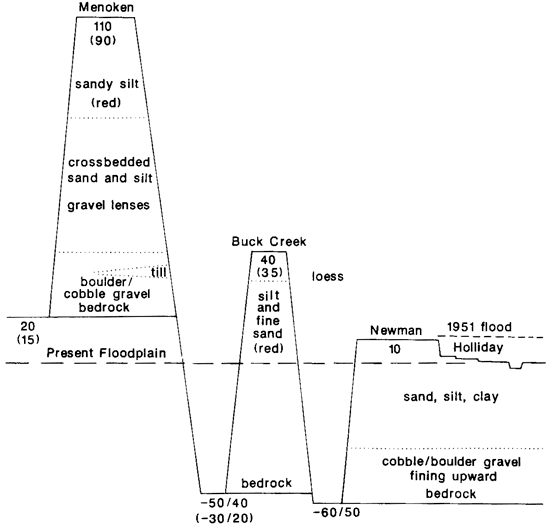
Names, stratigraphic relationships, and ages of terraces and alluvial fills of the Kansas River valley were initially proposed by Davis and Carlson in separate, though interrelated, Master's theses. The resulting framework of Menoken, Buck Creek, and Newman units, at once adopted by the Kansas Geological Survey, has been followed ever since. Close reading of publish descriptions of Kansas River terraces and underlying sediments reveals insufficiency of basic data as well as many discrepancies. Reported Menoken and Buck Creek elevational maxima and minima show major overlaps. Furthermore, the massive red sandy silt described for the upper part of each fill may be the same unit. Application to localized Kansas River sedimentary units of names derived from far afield is questionable.
A geomorphologist familiar with the magnificent terraces present along many streams in the semi-arid western United States would not be impressed by the poorly developed land forms of the Kansas River valley. Nevertheless, terraces are indeed present and have attracted geological attention for many decades.
Although the existence of terraces had previously been mentioned in the published literature, formal names were not proposed until the early 1950's. In Master's theses that were supervised by John C. Frye, then Director of the Kansas Geological Survey, Stanley N. Davis and William A. Carlson named and discussed the three most prominent levels. In order of decreasing elevation, hence decreasing age, these were designated the Menoken, Buck Creek, and Newman terraces. Details of the original descriptions are relevant to present investigations into the geomorphology and Quaternary history of northeastern Kansas. Davis (1951) studied the Kansas River valley near Topeka (from 6 mi (10 km] west to 9 mi [14 km] east); Carlson (1952) examined a reach extending from 11 mi (18 km) west of Lawrence to 2 mi (3 km) east.
Since he observed "pro-glacial outwash" and "pre-Kansan gravel" on the sides of the existing valley, Davis concluded that an "important" valley had been present in pre-Kansan time. Carlson (1952) agreed. Davis stated that because "the contact between early Pleistocene river sediments and bedrock is everywhere at least 20 feet above the present flood plain, it is quite certain that the surface of this ancient valley was at least [this high]." In the Lawrence area, Carlson found that the bedrock surface representing the depth of cutting by the Kansas River prior to the Kansan glaciation stood "8 to 10 feet above the Newman terrace surface," which would mean 15-20 ft (4.5-6 m) above the present floodplain.
Davis found that the "pre-Kansan gravel" contained a scattering of clasts of granite and quartzite. Fragments of granite could reach eastern Kansas only by stream transport from outcrops of the Ogallala Formation farther west or by glacier transport from the north. He suggested that this gravel was either Nebraskan outwash carried far south of the ice front or outwash from the advancing Kansan ice. He accepted the proposal by Lohman and Frye (1940) that the modern Kansas River originated as an ice-marginal stream during the Kansan glacial advance. Both Davis and Carlson agreed that the preglacial Kansas River "headed in the Flint Hills region east of Manhattan."
Davis believed that the preglacial Kansas River valley was "cut wider and a little deeper by melt water as the glacier advanced toward the area" and that the valley "was filled with glacial outwash which became progressively finer grained as the glacier was dissipated." He noted that the surface of this alluvial fill was "at least 80 feet above the present flood plain," and reported that in Menoken Township "accordant summits of the terrace are 90 feet above the flood plain." (He erroneously stated that this area is northeast of Topeka, but gave the correct township and range northwest of the city.) This surface was named by Davis--"it is here proposed to name this terrace the Menoken terrace from the township in which it is typically developed." Discussing the Lawrence area downvalley from Topeka, Carlson reported that the Kansas River valley was filled "to a height of 110 feet above the present flood plain."
In the Topeka area, Davis reported the presence, especially along the northern side of the valley, of glacial outwash locally more than 80 ft (24 m) thick. Of three well-defined zones, the lowest, at least 20 ft (6 m) thick, was composed of crossbedded, very coarse gravel containing about 10% erratic clasts. Because some of the boulders were very large, and till interfingered with the gravel, this sediment was correlated with the proglacial Atchison Formation. Overlying this unit was a discontinuous zone of sand and silt identified as the Grand Island member of the Meade formation and believed to represent outwash from the retreating Kansan glacier. The top unit consisted of 30-40 ft (9-12 m) of massive reddish sandy silt containing numerous scattered pebbles. This was assigned by Davis to the Sappa member of the Meade formation. In one statement he included this as part of the "outwash," while another statement, by emphasizing the outwash origin of the Grand Island, seemed to omit the Sappa.
Downriver near Lawrence, Carlson also reported "interfingering of terrace material with Kansas till." He said the "lower half of the terrace deposit" consisted of glacial drift, some of which had been slightly reworked, apparently by both streams and mass movements. Boulders up to 3 1/2 ft (1 m) long were numerous. Within and overlying the coarse debris was a thick zone of well-sorted, crossbedded coarse sand which, because it was composed mainly of quartz and feldspar, he believed to have been derived from breakdown of igneous and metamorphic erratics. In the upper part of the deposit, fine sand graded upward into silt and clay, some of which was a deep-red color, probably produced by "the long period of weathering." The silt was believed to represent the final stage of deposition "immediately following the retreat of the Kansas ice sheet." The silt was called Sappa, the sand and gravel Grand Island.
Both Davis and Carlson believed that sediments they called Grand Island originated as glacial outwash and were, therefore, of Kansan age. This also seemed to hold true for sediments they called Sappa. They spoke of the surface of this deposit as being the Menoken terrace and implied that this is a fill-top or depositional surface. If both of these assumptions are correct, then the surface they called the Menoken terrace was indeed formed during retreat of the Kansan ice sheet.
In the Topeka area, according to Davis, formation of the Menoken terrace (he must mean the depositional surface) was followed by "a period of erosion in which the bedrock floor of the Kansas River valley was cut 40 to 50 feet below its former level. After this entrenchment the valley was again aggraded to about 40 feet above the present flood plain." Inasmuch as he found the pre-Kansan bedrock surface at least 20 ft (6 m) above the present floodplain, this indicates downcutting of the bedrock to a level 20-30 ft (6-9 m) below the present floodplain, then aggradation of some 60-70 ft (18-21 m) of sediment.
For the Lawrence area, Carlson commented only briefly about events immediately following formation of the Menoken surface. He spoke of "a period of downcutting which occurred during and after the formation of the Menoken terrace which lowered the bedrock channel approximately 60 to 70 feet." That would seem to permit the accumulation of as much as 90 ft (27 m) of fill during the subsequent episode of aggradation.
Davis said that "this terrace has been named the Buck Creek terrace (Carlson, 1951 [sic]) from a well-developed surface northwest of Lawrence." Carlson did not indicate in his thesis that he was proposing a new name, so the statement by Davis provides the only evidence regarding the origin of the designation. On the basis of the selected name, it can be supposed that the type area is where "Buck Creek remnants in the main valley occur along Buck Creek . . . where it flows from the bedrock uplands onto the terrace flats of the Newman level."
In any event, both Davis and Carlson clearly implied that the name was given to the surface formed by the top of the post-Menoken aggradation-a fill-top surface. Carlson reported that "the altitude of the terrace is 20 to 25 feet above the Newman level," which would place it 28-33 ft (8-10 m) above the present floodplain. Davis spoke of terraces "probably equivalent to the Buck Creek terrace" yet only 15-25 ft (4.5-7.5 m) above present floodplains, but these were apparently restricted to tributary valleys.
Davis' geologic map contains no areas specifically identified as Buck Creek terrace, but he spoke of red clayey silt in "probably equivalent" terrace deposits along tributary valleys. Carlson reported that "the material constituents underlying the Buck Creek terrace surface consist primarily of silt and fine sand." A drill hole in the type area penetrated 90 ft (27 m) of uniform sediment which Carlson suggested had been deposited by a low-gradient, high-discharge phase of the river. He emphasized the "brownish red" color of the sediment, at least along minor tributary creeks.
In keeping with the sparsity of possible Buck Creek terrace remnants in the Topeka area, Davis stated only that "the age of the Buck Creek terrace is not known, but the evidence indicates that it is younger than Kansan and older than Mid-Wisconsinan." Carlson was more precise, though on the basis of little clear evidence. Referring specifically only to a railroad cut west of Lawrence, he reported that "a terrace deposit composed of gravel, sand, and clay considered to be a remnant of the Buck Creek terrace" was overlain by "Loveland and Peoria loess deposits separated by a soil zone." He concluded that "this stratigraphic sequence, together with the physiographic relation to the Kansan age Menoken terrace, places the Buck Creek terrace deposits as the Crete member of the Sanborn formation of Illinoian age." Carlson gave no evidence on which he based identification of the two loess units. However, in a "small patch" near Topeka, Davis also found two loesses. He called the upper one Peoria on the basis of depth of leaching and extent of soil development. The lower loess was believed to be Loveland because "it is much older than the overlying loess," whatever that might mean.
Both Davis and Carlson noted that most of the Buck Creek terrace had been removed, especially along the Kansas River valley. Davis attributed this to "lateral erosion of the river" and explained that the Menoken terrace is better preserved because "it has a much higher bedrock floor which has effectively resisted erosion." Carlson agreed that the Menoken is a "rock-defended terrace" and that because "the lower portion of the bedrock channel extends beneath the Buck Creek terrace ... subsequent lateral cutting by the river removed essentially the entire deposit."
For the Lawrence area, Carlson reported that "a minor amount of downcutting of the bedrock may have occurred during the period immediately following removal of the Buck Creek deposits as the bedrock floor seems to have been lowered about 5 to 10 feet." This was followed by "another period of alluviation" which contributed to the formation of a well-developed terrace surface that occupies as much as half of the valley floor in some areas. Davis wrote that "the terrace is jointly named here and by Carlson (1951 [sic]) the Newman terrace."
In the type area, in the vicinity of the town of Newman west of Lawrence, the Newman terrace is "approximately 8 feet above the general flood-plain surface." The extensive terrace surface is characterized by "its almost complete lack of topographic expression"; it is "virtually undissected." This means that almost all information about underlying sediments must be acquired from drill holes.
Davis reported that the alluvial fill in the Kansas River valley reaches "a maximum thickness of 80 feet." Inasmuch as this statement was placed beneath the heading "Late Pleistocene and Recent alluvium," there is at least the implication that this is the depth of fill of that age. He noted that "in general, the alluvial fill grades upward from a very coarse cobble fill to a fine sand or silt at the surface. The upper 40 feet of alluvium is believed to be the result of river deposition similar to that of today," but drilling encountered boulders at greater depths. He also stated that "the Newman terrace is underlain almost entirely by silt and silty clay which ranges from 15 to 30 feet in thickness. Much of this finer material is 'backswamp' deposit."
For the Lawrence area, Carlson found that the alluvium consisted of "alternate layers of clay, silt, and fine to medium sand," but "the progressively older underlying sediments show a distinct continuous gradation to coarser material. Boulders of quartzite 3 to 4 feet in diameter are not uncommon at the base of the deposit in direct contact with the bedrock . . . More commonly the deposits at the base overlying the bedrock consist of coarse gravels of various rock types." He noted that "the upper layers ... are quite uniform and continuous" and he suggested that "the continuity of the sediments seems to imply that the depositing river flowed in a constricted channel, that it did not meander across its valley."
According to Davis, "the age of the alluvial fill is believed to range from late Wisconsinan to Recent." He noted that the great flood of 1903 overlapped the margins of the Newman terrace and the flood of 1844, supposedly 2 ft (.6 m) higher, probably covered a large part of the terrace. He concluded that "the greater part of the valley is still aggrading." Carlson reported that "considerable quantities of silt were deposited by the flood of 1951."
As soon as they were completed, the Master's theses by Davis and Carlson were combined and published as Bulletin 96, Part 5, of the Kansas Geological Survey (Davis and Carlson, 1952). Very few changes were made in quantitative content and interpretations were not explained more completely.
The height of the base of early Pleistocene river deposits was first given as being "everywhere at least 15 feet above the present flood plain." A second statement reported that the "bedrock base of the Meade formation . . . is at least 10 feet above the present flood plain." This is a little lower than given in Davis' thesis.
It was specifically stated that "the upper surface of these [Meade] deposits forms a high terrace which is mapped as the Menoken terrace, and which is discontinuously mantled with loess, eolian sand, and sand derived from slope wash. These thin surficial deposits range in age from Illinoian to Recent." The lowest, bouldery zone of the Meade was said to "in many localities" attain a thickness of "at least 30 feet."
Bulletin 96 further stated that "following formation of the Menoken terrace there was a period of erosion in which the bedrock floor of the Kansas River Valley was cut 50 to 60 feet below its former level. After this entrenchment the valley was again aggraded to about 35 feet above the present flood plain."
Referring to the Buck Creek terrace, Bulletin 96 remarked that "its age is judged to be Illinoian as the terrace fill truncates deposits of Kansan age and has a well-developed soil (Sangamon) at the surface which is discontinuously mantled by Peoria loess." Furthermore, the silt that was found by drilling to be 90 ft (27 m) thick at Buck Creek School "is classed as the Loveland silt member of the Sanborn formation." In a railroad cut near Tecumseh, it was concluded that "the Loveland silt of this area is in part, if not entirely, an alluvial deposit, the upper surface corresponding to the Buck Creek terrace."
Under the heading "Wisconsinan and Recent alluvium" it was reported that "all river and major stream valleys in the area have deep alluvial fills which reach a maximum thickness of almost 90 feet in the Kansas River Valley" and "the age of the alluvial fill ranges from Wisconsinan to Recent since these deposits truncate Illinoian terrace fills."
Concurrently with completion of theses by Davis and Carlson and preparation of Bulletin 96, the Kansas Geological Survey also published Bulletin 99, Pleistocene geology of Kansas (Frye and Leonard, 1952). This latter bulletin repeated previous statements that "the Meade formation underlies the surface of extensive dissected remnants of the Menoken terrace . . . This terrace, where it has been studied eastward from Topeka, stands approximately 80 feet above Kansas River flood plain and has a bedrock floor approximately 20 feet above the flood plain."
Bulletin 99 also stated that "along the Kaw Valley Crete deposits underlie the surface of disconnected small remnants of the Buck Creek terrace" and "alluvial Loveland silt occurs as the upper part of the deposits of the Buck Creek terrace." Furthermore, "a major episode of valley incision occurred after the deposition of the late Kansan Meade formation in the [Kansas River] valley and prior to the deposition of the late Illinoian Crete member."
The terrace names, stratigraphic relationships, and ages proposed by Davis and Carlson and, of course, their supervisor, Frye, at once became an accepted framework within which all later studies had to be placed. However, most reports compiled to describe the geology of a specified area, such as a Kansas county, devoted little attention to stream terraces or geomorphic history.
For Wabaunsee County, which lies just west of Topeka, the bulletin by Mudge and Burton (1959) noted that Grand Island, Crete, and Loveland sediments may all have a "red-brown" color but, strangely, not the Sappa, which is described as being red almost everywhere else. It further reported that the Buck Creek terrace is "about 60 feet above the stream bed" and the Newman terrace is "10 to 15 feet above the present stream bed." Surely, the intended meaning was floodplain rather than channel bed, although the bulletin also stated that "the younger terrace [Newman] ranges in elevation above the stream bed from a few feet along the small streams to 60 or more feet along the Kansas River." That statement must include a numerical misprint of the highest elevation.
The bulletin about Douglas County, which includes Lawrence (O'Connor, 1960), remarked that "the name Menoken Terrace is used only as a geomorphic term . . . for a terrace on sediments of Kansan age in the Kansas River Valley." It also was noted that "the Loveland Formation . . . chiefly reddish . . . constitutes most of the [Buck Creek] terrace fill and is at least 62 feet thick locally ... The Sangamon soil, which is well developed on Buck Creek Terrace deposits, is characterized by its reddish color and thick clayey B horizon."
Bulletins for Shawnee County, in which Topeka is located (Johnson and Adkison, 1967; Johnson and Wagner, 1967), noted that north of the Kansas River, Sappa massive, pale-red, clayey silts "of glaciofluvial and glaciolacustrine origin" are "more than 40 feet thick in places." The Buck Creek deposits were reported to be "about 30-80 feet above the [Kansas] river and are often 'reddish-brown.'" Also included was the startling statement that "the extensive remnant of the Buck 'Creek terrace along the west side of Cross Creek [4 miles] north of Rossville ranges in height from about 20 feet to as much as 90 feet above the creek . . . the higher part of the deposit overlies bedrock." This upper limit is equal to that usually given for the Menoken terrace.
Dufford (1958) specifically discussed the Quaternary geology of the Kansas River valley from Lawrence downstream to Bonner Springs, although the emphasis was on ground-water resources. He recognized unusually extensive remnants of the Menoken terrace on both sides of the river at a height of about 90 ft (27 m) above the present floodplain in the general vicinity of Eudora. He reported that "locally ... the entire stratigraphic sequence underlying the Menoken Terrace consists of massive sandy silt. More than 80 feet of Sappa . . . red to light brown . . . silt is present in some parts of the area." He also spoke of "the characteristic red clayey silt underlying the exposed sections of all Buck Creek Terrace remnants throughout the area."
A more detailed discussion of Quaternary history was provided by Beck in his 1959 bulletin about the geology and ground-water resources from Topeka upstream to Wamego. This detail is not surprising since he was a geomorphologist. He reported that "the floor of the Menoken Terrace deposits . . . glacial outwash . . . ranges from 20 to 40 feet above the present flood plain" and "the bedrock surface on which pro-Kansan sediments were deposited is 50 to 75 feet below the surface underlying pre-Kansan gravels . . . The Menoken Terrace is about 60 feet above the Newman Terrace," or about 75 ft (23 m) above present floodplain.
Beck also stated that "the bedrock surface on which Illinoian sediments were deposited is 25 to 50 feet below the surface on which Kansan sediments were deposited . . . In the waning phase of Illinoian time . . . the [Kansas River] valley again was alluviated to a level about 30 feet above the Newman Terrace" or about 45 ft (14 m) above present floodplain. "The remnants of these deposits are the Buck Creek Terrace deposits . . . The thickness of these [Buck Creek] deposits ranges from about 35 feet ... to 96 feet . . . The upper part of the fill is a reddish-brown silt and clay upon which the Sangamon soil developed . . . Some of the finer material in the upper part of the Buck Creek Terrace deposits may be of eolian origin . . . The bedrock surface on which the Newman Terrace deposits accumulated lies 50 to 80 feet below the terrace surface . . . which may be as much as 15 feet above the flood plain."
Fader (1974) published a report on ground-water supplies in the Kansas River valley which included maps showing areas of Newman and Buck Creek terrace deposits between Junction City and Kansas City. Mapping was limited by what he termed valley margins and all Menoken terrace deposits were excluded. The accompanying text contained no information about the terrace sediments.
Close reading of available descriptions of Kansas River terraces and sub-terrace sediments reveals a basic framework (fig. 1) but considerable variation in detail, as well as a notable absence of critical evidence, especially for claimed truncation of one fill sequence by another. All subsequent authors used the three-fold classification established by Davis and Carlson, identifying entities they called Menoken, Buck Creek, and Newman. However, use of terminology has been sloppy. Many authors spoke of a "terrace," a geomorphic surface, when actually discussing the sediment underlying the terrace.
Figure 1--Schematic representation of the erosional/depositional history of the Kansas River through Pleistocene and Holocene time as proposed by Carlson (1952) and Davis (1951) and followed by subsequent authors.
In actuality, there is no necessary equivalency of the age of the sediment and the age of the overlying surface. A terrace (surface) at the upper limit of a sedimentary unit might be the same age as that sediment, a fill-top terrace, or it might be significantly younger, an erosional or fill-strath terrace. This latter possibility apparently has not been considered for any Kansas River surface.
There is general agreement that a coarse bouldery gravel, where present, was a product of direct glacial outwash and should therefore be called the Grand Island member of the Meade formation. Other than that, however, most unit identification has been based principally on topographic position. If a sandy silt is "high" above the present floodplain, then it "must be" the Sappa member of the Meade formation and therefore part of the Menoken "terrace fill." If it is "low," it "is" the Loveland silt member of the Sanborn formation and part of the Buck Creek filL Both the Sappa and the Loveland are described as sandy silt and the color of each has been described as red or reddish brown. A critical reader of these reports is, therefore, led to wonder if the Sappa and the Loveland might be one and the same sedimentary unit that is present through a considerable range of heights above (and below) the modern floodplain.
In its type area, the Menoken fill is described as being a sequence that becomes finer upward, the lowest part bouldery gravel with interfingering till, above which there is pebble gravel, then sand, then silt. However, new excavations visited during the 1986 Friends of the Pleistocene field trip expose till very near the so-called Menoken terrace level with only thin loess above. This relationship obviously raises questions about the original interpretation of that terrace. It may well be an erosional surface that bevels several sedimentary units.
Some authors identified sediment units on the basis of the position of the underlying bedrock floor relative to present floodplain. This criterion also will not bear close scrutiny. A considerable range of positions has been given for each rock floor; there may even be more than the recognized three. Certainly, the nature of the overlying sediment varies from one location to another. An exposure visited by the Friends trip near Rossville shows red sandy silt of the Loveland--or perhaps Sappa?--type, but it rests on a bedrock floor about 20 ft (6 m) above the floodplain, a basal Menoken position.
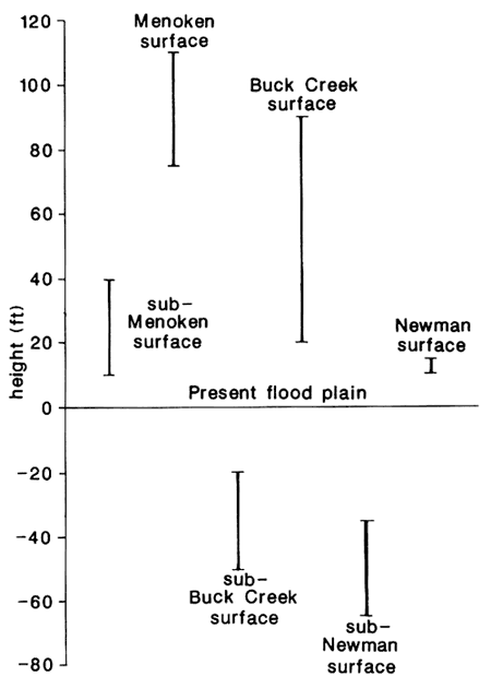
Finally, serious questions can be raised about the propriety of applying stratigraphic names derived from distant sites to deposits localized along the Kansas River valley. Meade, Grand Island, Sappa, Sanborn, Crete, Loveland--not one of the type localities is related to the mainstem Kansas River; some are not even in the same drainage basin. Lithologies and sedimentary characteristics of the named units seem to vary from one report area to the next. On the other hand, in one report or another every one of the units has been described as red. Furthermore, tabulation of ranges of critical heights as given by various authors shows considerable overlap (fig. 2). Clearly much additional surface mapping and subsurface exploration must be accomplished before the Quaternary history of the Kansas River valley can be accurately reconstructed. The very existence of the conceptual Menoken and Buck Creek terraces needs to be reexamined; only for the Newman does the validity seem secure.
Figure 2--Ranges of elevations of bedrock floors and terrace surfaces along Kansas River valley as reported by various authors.
Beck, Henry V., 1959, Geology and ground-water resources of Kansas River valley between Wamego and Topeka vicinity: Kansas Geological Survey, Bulletin 135, 88 p. [available online]
Carlson, William A., no date (1952?), Quaternary geology and ground-water resources of the Kansas River valley between Newman and Lawrence, Kansas: M.S. thesis, University of Kansas, 94 p.
Davis, Stanley N., 1951, Quaternary geology and ground-water resources in the vicinity of Topeka, Kansas: M.S. thesis, University of Kansas, 74 p.
Davis, Stanley N., and Carlson, William A., 1952, Geology and ground-water resources of the Kansas River valley between Lawrence and Topeka, Kansas: Kansas Geological Survey, Bulletin 96, part 5, p. 201-276. [available online]
Dufford, Alvin E., 1958, Quaternary geology and ground-water resources of Kansas River valley between Bonner Springs and Lawrence, Kansas: Kansas Geological Survey, Bulletin 130, part 1, 96 p. [available online]
Fader, Stuart W., 1974, Ground water in the Kansas River valley-Junction City to Kansas City, Kansas: Kansas Geological Survey, Bulletin 206, part 2, 12 p. [available online]
Frye, John C., and Leonard, A. Byron, 1952, Pleistocene geology of Kansas: Kansas Geological Survey, Bulletin 99, 230 p. [available online]
Johnson, William D., Jr., and Adkison, W. L., 1967, Geology of eastern Shawnee County. Kansas, and vicinity: U.S. Geological Survey, Bulletin 1215-A, p. 1-123. [available online]
Johnson, William D., Jr., and Wagner, H. C., 1967, Geology of western Shawnee County, Kansas, and vicinity: U.S. Geological Survey, Bull. 1215-B, p. 125-254. [available online]
Lohman, Stanley W.. and Frye, John C., 1940, Geology and ground-water resources of the "Equus beds" area in south-central Kansas: Economic Geology, v. XXXV, p. 839-866.
Mudge, Melville R., and Burton, Robert H., 1959, Geology of Wabaunsee County, Kansas: U.S. Geological Survey, Bulletin 1068, 210 p.
O'Connor, Howard G., 1960, Geology and ground-water resources of Douglas County, Kansas: Kansas Geological Survey, Bulletin 148, 88 p. [available online]
Prev--Soils and geomorphic surfaces || Next--Holocene alluvial-stratigraphic studies
Kansas Geological Survey
Comments to webadmin@kgs.ku.edu
Web version updated March 16, 2010. Original publication date 1987.
URL=http://www.kgs.ku.edu/Publications/Bulletins/GB5/Dort2/index.html