Kansas Geological Survey, Guidebook 4, originally published in 1979
Prev Page--Field Guide and Road Log
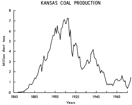
Coal deposits in Kansas have been exploited for over one hundred years with a total production of nearly 270 million metric tons (300 million short tons). There were two major peaks in production during this time period corresponding to World War I and World War II (Fig. 1). The availability and use of natural gas and petroleum in Kansas were the primary factors in the decline of Kansas coal production. However., the more recent decline in availability of natural gas and the greatly increased cost of petroleum for power generation and industrial use are resulting in a resurgence in the use of coal. In the United States the 625 million metric tons (689 million short tons) produced in 1977 was the largest amount produced in one year. For Kansas the 1978 coal production was 1.3 million metric tons (1.4 million short tons), and the outlook is for increased coal production over the next twenty years.
Figure 1--Kansas coal production 1869-1978.
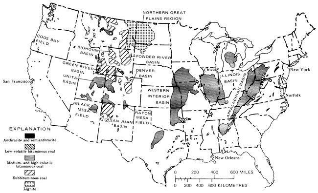
Carboniferous coal deposits of Kansas crop out in the eastern one-fourth of the state. The large coal-bearing area in the central United States that includes most of the Kansas coal is the Western Interior Basin (Fig. 2). Nearly all of the coal in this major coal basin is of bituminous rank. Over 50 bituminous coal beds have been identified in Kansas, 17 of which have potential for commercial production. Most of the coals have widespread distribution in Kansas and all are considered to have been deposited in large swamp areas located close to a mid-continent sea.
Figure 2--Distribution of major coal areas in United States (from Averitt, 1975, p. 5).
The best estimate of coal resources in Kansas is nearly 20.6 billion metric tons (22.7 billion tons) by Averitt (1975), and this figure represents less than one percent of all U.S. coal resources which total slightly under four trillion tons. This Kansas estimate is based primarily on earlier Kansas Geological Survey studies by Abernathy, Jewett, and Schoewe (1947) and Schoewe (1958).
Kansas coal has two general characteristics that limit its development and use:
The thin nature of Kansas coal beds is also a major factor in development of the coal resources because of the mining costs of working a larger area than would be required for a thicker coal bed. Of the Kansas coal resource, less than 2.7 billion metric tons (3 billion short tons) is close enough to the surface to be surface-mined regardless of bed thickness.
As the tonnage of coal obtained by deep mining decreased, the percentage of coal produced by strip mining increased until 1964, when all Kansas coal production was won by surface-mining methods. With the lower costs and increased safety of surface mining and the presence primarily of thin coal beds in Kansas, it is anticipated that future mining will continue to be by surface mining methods. Therefore, because of the thin nature of Kansas coal beds and the strong emphasis on strip mining, most of the Kansas coal resource tonnage will never be mined unless there are significant future developments in mining technology or perhaps in underground gasification techniques, which can utilize Kansas coal.
The strippable coal reserve base in Kansas is estimated by Brady et al. (1976) to be 477 million metric tons (526 million short tons) for coals under an overburden thickness of at most 30 times the thickness of the coal. An areal limitation of 0.75 mile (1.2 km) from a known coal thickness was used for the estimate. Besides the 477 million metric tons (526 million short tons), there is an additional coal amount of nearly 725 million metric tons (800 million short tons) located within a three-mile (5-km) radius from a known data point and still having at most a 30:1 overburden/coal ratio.
Seventeen different coal beds occurring in five different rock groups in Kansas have the potential for economical development by strip mining. Over 50 percent of the reserve base is represented by coals of the Cherokee Group and an additional 20 percent by the Marmaton Group (Fig. 3 shows stratigraphic distribution of the coal beds). Among the coal beds in Kansas having the largest strippable coal reserves are the Mineral and Bevier coals of the Cherokee Group, Mulberry coal of the Marmaton Group, and Nodaway coal of the Wabaunsee Group. These four coals make up 64 percent of the strippable coal reserve base. Of these four coals, only the Nodaway is not presently being mined in Kansas. A generalized areal distribution of the various strippable coals is shown in Fig. 4.
Figure 3--Coals of economic importance in the southeastern Kansas coal field (modified from Zeller, 1968). Economic coals marked by *.
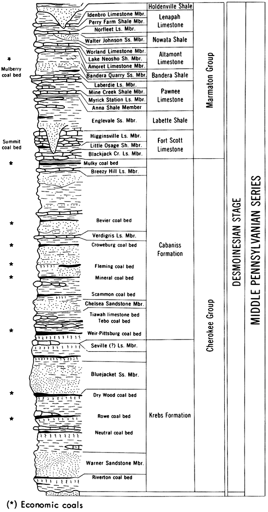
Figure 4--General distribution of strippable coal reserves by geologic group for coals under 30 meters (100 feet) of overburden or less.
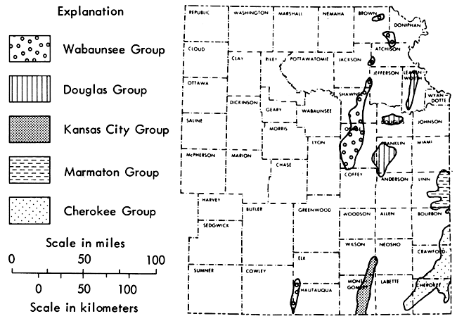
There are 23 counties in eastern Kansas that contain strippable coal,and three of the counties (Cherokee, Crawford, and Linn) contain 66 percent of the strippable reserve base. Future coal mining in Kansas will probably be concentrated in these three counties with significant mining also in Bourbon County.
After having reached the low point in coal production of 469 thousand metric tons (517 thousand short tons) in 1975, Kansas coal started a rapid recovery that should result in a continued increase in coal production for a number of years.
With continued interest, 1979 coal production should approach 1.4 million metric tons (1.5 million short tons). Increased demand by the electric power companies and cement manufacturing companies in Kansas and Missouri are the important markets for Kansas coal.
When the Pittsburg and Midway Coal Mining Company starts mining its coal properties in Linn County, at a time anticipated to be in 1980, Kansas coal production should show a marked jump in production of nearly 0.9 million metric tons (1 million short tons). By 1985 Kansas coal production could be near 2.7 to 3.6 million metric tons (3 to 4 million short tons) of annual production.
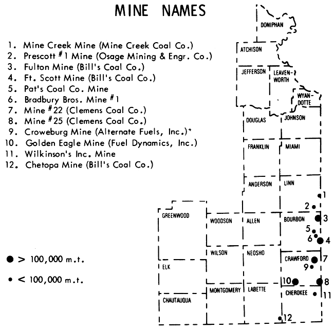
At the present time, there are 12 coal mines in constant or periodic operation in Kansas (Fig. 5). The larger of these mines include Clemens Coal Company's Mine #22 (Stop 10 in preceding field guide) and Mine #25 in Crawford County, and Bill's Coal Company's Fort Scott Mine and Fulton Mine, both in Bourbon County, and Fuel Dynamic's Golden Eagle Mine in Crawford County.
Figure 5--Location of coal mines operating in Kansas in 1979.
Quality of the different coal beds is quite variable, but the commercial coal beds generally show the following ranges:
| Moisture | 3-6 percent |
| Ash | 11-20 percent |
| Sulfur | 3-6 percent |
| Heat content--as received | (23,200-29,500) (Kilojoule/kg) |
| 10,000-12,700 BTU/lb | |
| Heat content--ash and moisture free | (33,000-35,100) (kJ/kg) |
| 14,200-15,100 BTU/lb |
The coals of higher quality (low ash and low sulfur content) are utilized directly from the mine following crushing and screening, while the poorer quality coals first are washed for ash and sulfur removal.
Abernathy, G.E., Jewett, J.M., and Schoewe, W.H., 1947, Coal reserves in Kansas: Kansas Geol. Survey, Bull. 70, pt. 1, 20 p. [available online]
Averitt, Paul, 1975, Coal resources of the United States, January 1, 1974: U.S. Geol. Survey, Bull. 1412, 131 p.
Brady, L.L., Adams, D.B., and Livingston, N.D., 1976, An evaluation of the strippable coal reserves in Kansas: Kansas Geol. Survey, Mineral Resources Series no. 5, 40 p. [available online]
Schoewe, W.H., 1958, The geography of Kansas: Pt. IV, Economic geography: Mineral resources: Trans. Kansas Acad. Sci., v. 61, p. 367-391.
Zeller, D.E. (ed.), 1968, The stratigraphic succession in Kansas: Kansas Geol. Survey, Bull. 189, 81 p. [available online]
Sandstones of the Krebs Formation, the lower half of the Cherokee Group in southeastern Kansas, contain scattered deposits of heavy crude oil. The discontinuous nature of these oil-bearing sands has recently led to reductions in the estimate of amount of oil resources that is present. Drilling has shown that the previously defined stratigraphy of these rocks (which is based on incomplete surface exposures) had lumped four or more sandstone intervals into only two named units in the lower Cherokee. These sandstones are parts of alluvial-deltaic systems and are associated with shales, coals, and thin limestones in cyclic sequences that are similar to other clastic-dominated cyclothems of the Midcontinent. Crude oils in these rocks have been altered to heavy-oils by contact with fresh water and by bacterial biodegradation during shallow burial.
Lenticular sandstones of the lower Cherokee Group at the surface, and in the shallow subsurface of southeastern Kansas and contiguous areas of Missouri and Oklahoma, are economically important because they contain deposits of heavy-oil, or "tar," which may be a potential resource of fuel for the future. These deposits have not been developed, because of uncertainties concerning the size of the resource and the nature of the reservoir rock, and the effect that these uncertainties have on the economics of recovery. Earlier estimates of size of the heavy-oil resource have been reduced by recent studies, because of a reduction in estimates of the volume of reservoir rocks in the subsurface. Instead of being widespread, uniformly thick, even-textured sandstones, as had been assumed earlier, the lower Cherokee Group sands have proven to be lenticular, discontinuous, and inhomogeneous. Sedimentologic interpretation has been important in the improved understanding of these sandstones.
An area comprising Bourbon, Crawford, and Cherokee Counties, Kansas, was the scene of a recent program of stratigraphic drilling and surface-outcrop study (Ebanks et al., 1977). The new information, coupled with older control, provides an interpretation of the distribution of sandstone in the lower Cherokee, which is still being tested.
In general, the Cherokee Group dips slightly north of westward at the rate of 4-6 meters per kilometer (20-30 ft./mi) (Fig. 1). The trend of outcrop in Crawford and Cherokee Counties affords the opportunity of seeing exposures of sandstones and related sediments (Stop 9 in preceding field guide), which are equivalent stratigraphically to subsurface coals and oil-bearing rocks farther west.
Figure 1--Cross-section of southeastern Kansas showing structural attitude of Middle Pennsylvanian Cherokee (dash and dot patterns) and Marmaton (brick pattern) Groups. Vertical exaggeration approximately 100:1.
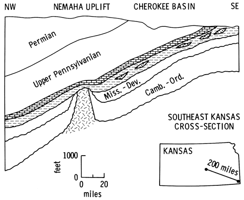
The Cherokee lies unconformably on the irregular surface of Middle or Upper Mississippian carbonates, the top of which also dips westward. Overlying the Cherokee is the Marmaton Group of limestone and shale formations (Fig. 2). The Cherokee Basin of the tri-state area is a shallow, northward extension of the Arkoma Basin of northern Oklahoma. The Cherokee Group thickens southward and is underlain by older Pennsylvanian Atokan and Morrowan formations south of the Kansas-Oklahoma line.
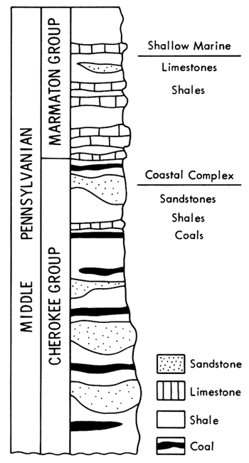
Figure 2--Schematic stratigraphy of Cherokee and Marmaton Groups in southeastern Kansas. Krebs Formation constitutes approximately lower one-half of Cherokee; Cabaniss Formation constitutes upper one-half.
Cherokee beds have probably never been buried by more than 1070 m (3500 ft.) of younger Pennsylvanian, Permian and Cretaceous rocks, which were eroded away during the Cenozoic. West of the area described here, there is as much as 600 m (2000 ft.) of rock section presently above the Cherokee. Gravity of oils in Cherokee sandstones generally increases with depth of burial westward, but in the eastern part of the Cherokee Basin, medium- and low-gravity oils occur in a seemingly random pattern with respect to depth (Ebanks and James, 1974). The shallowest occurrences of oil-impregnated rock, in western Missouri, are mined at the surface as tar sands.
Rocks of the Cherokee Group were the earliest of the Pennsylvanian and Permian cyclic sequences deposited in the Midcontinent area (Moore, 1950; Howe, 1956). Cherokee sediments are mainly terrigenous clastic sandstones and shales, interbedded with thin coal deposits and underclays and a few thin limestone beds. Later cyclic sequences, such as the Upper Desmoinesian Marmaton Group (Fig. 2), include far more limestone and very little coal, supporting the concept of increasingly widespread marine invasion of this area throughout middle and later Pennsylvanian time, with variation in environmental conditions as the interplay of sea level, sediment supply, and basin subsidence changed.
In this setting, the Cherokee Basin has been depicted as the site of shifting and prograding alluvial and deltaic plains, estuaries, tidal delta complexes, beaches, and shallow marine shelf environments (Bass, 1936; Baker, 1962; Hayes, 1963; Visher et al., 1971; Ebanks et al., 1977). Individual sand bodies in the Cherokee section have been described variously as ancient nearshore bars (Dillard et al., 1941), barrier islands (Bass, 1936), tidal flat and channel deposits (Hayes, 1963), and alluvial valley-fill sediments (Rich, 1923; Charles, 1941; McQuillan, 1968). Probably each of these interpretations is correct in some area.
The predominant mode of deposition of heavy-oil-bearing sandstones in the area discussed here is the repeated extension of alluvial-deltaic complexes from the east, westward into Kansas and, ultimately, southward into Oklahoma. Each extension resulted in lobes or belts of sandy deposits prograding into or over both marine and nonmarine environments in which mostly muddy or silty sediment had been deposited or where peat swamps had formed. The sands deposited in this manner are highly lenticular and discontinuous, not blanket-like and continuous. This distinction is of great importance in formulating estimates of potential oil reservoir rock and, thereby, of oil resource in the area.
Heckel (1978, p. 18-19) has noted the similarity of the basic cyclic sequence established by Moore (1949, 1950) in the Cherokee of Kansas to the classical cyclothems of Illinois. This similarity along with the occurrence of Cherokee cycles just below younger Pennsylvanian cyclic sequences led Heckel (ibid.) to interpret certain Cherokee cycles as shoreward, clastic-dominated equivalents of the typical, more marine, limestone-dominated cycles of the Marmaton and younger groups. This interpretation is consistent with field relationships and with subsurface geologic data (Visher et al., 1971; Ebanks et al., 1977; J.S. Wells, in prep.), but control over deposition of many Cherokee cyclothems may be due more to normal nearshore sedimentary processes than to eustatic changes in sea level (see introductory discussion in preceding field guide).
The lower half of the Cherokee section in Kansas, the Krebs Formation, includes a larger proportion of sandstone beds than does the upper half, the Cabaniss Formation, in most areas of surface exposure. Conversely, coals in the Cabaniss are more numerous, thicker, and more persistent than those in the Krebs.
Traditional stratigraphic nomenclature of Kansas, Missouri, and Oklahoma has not recognized the non-continuous nature of many of the sandstones in the Cherokee Basin area; rather, these classifications of formations have fostered the widespread use of the same name for sandstones in approximately the same stratigraphic position in widely separated areas. Subsurface logging data from 33 recently drilled stratigraphic test holes have indicated that, instead of two predominantly sandstone beds in the Krebs of southeastern Kansas, there are at least four well developed sandstones. These discontinuous, sandy intervals are readily correlated throughout the whole area by recognition of persistent limestones, coals, and radioactive black shale stratigraphic markers.
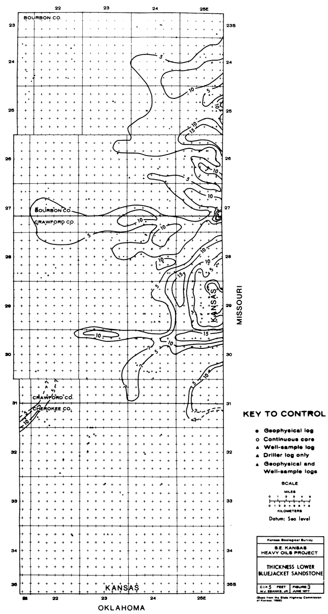
Depicted here (Figs. 3 and 4) are the distributions of the two upper sandstones, the upper and lower Bluejacket sandstones (informal names) , which are described in outcrop at Stop 9 in the preceding field guide. Lower in the section are the upper and lower Warner sandstones (Ebanks et al., 1977), which are of similar discontinuous nature.
Areas of deposition of the lower Bluejacket sandstone are mostly near the Kansas-Missouri border (Fig. 3). This sandstone is widespread in western Missouri (J.S. Wells, in prep.). In Kansas, the lower Bluejacket is confined to narrow areas of elongate shape or to discontinuous, lobate areas of thicker sandstone. It occurs only in a few scattered outcrop localities in southeastern Kansas, and it is almost completely absent in Cherokee County, adjacent to Oklahoma.
Figure 3--Thickness of sandstone in lower Bluejacket interval in part of southeastern Kansas.
The youngest of the heavy-oil-bearing units is the upper Bluejacket sandstone. In Kansas, its thickness is almost always less than 4.5 m (15 ft.) (Fig. 4). In contrast to the lower Bluejacket, this unit is very thin and difficult to recognize in the Kansas-Missouri border area, but it thickens noticeably southward toward Oklahoma where it is much more widespread.
Figure 4--Thickness of sandstone in upper Bluejacket interval in part of southeastern Kansas.
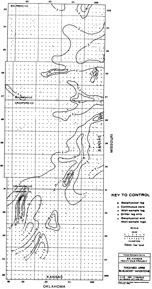
These patterns of distribution strongly suggest that these sandstones were deposited in river- and delta-related continental environments. Sedimentary structures in individual sandstones support this interpretation. Commonly, in areas of thickest sandstone, the rock near the base consists of massive, or low-angle cross-bedded, fine-grained sandstone with clasts of sideritic mudstone, fossilized wood, and fine, sometimes distorted, laminae of carbonaceous matter. Overlying this lower zone in some cases is an interval of ripple cross-bedded sandstone, which is, in turn, overlain by a trough cross-bedded unit. This trough cross-bedded sandstone, which is fine or medium grained, is usually the best sorted and most permeable sand in the vertical sequence. Next higher is another ripple cross-bedded or horizontal-laminated very fine or fine micaceous sandstone with thin shaly laminae. Fossil plant remains and shredded carbonaceous matter are disseminated throughout the micaceous sandstone. The uppermost beds are thinly interbedded sand and shale, usually with bioturbation. In areas where the sandstone is less than 2 m (6.6 ft) thick, the whole sandstone consists of wavy, ripple cross-bedded, very fine or fine sandstone, which is gradational to silty shale above and below.
This sequence of structures suggests a transition from slower, lower-energy, sand-depositing currents through a time of more rapid currents, and returning to more quiet-water conditions. The sandstones may represent deltaic distributary-mouth bar deposits, which are cut into by their own prograding alluvial channel-fill deposits, or, alternatively, crevasse-splay sands through which channels were cut and later abandoned.
These events suggest that shallow-water deltaic complexes extended rapidly and repeatedly during deposition of the Krebs Formation from western Missouri westward and southward into Kansas and Oklahoma. Silty, ferruginous shales, underclays, and coals above or below the sandstones are delta-plain sediments. Dark gray sideritic shales underlying the sandstones in some cases probably were deposited in inter-distributary bay and delta-front environments. Occasional thin limestones and calcareous shales or siltstones were deposited on the floor of the shallow marine environment in front of the delta at some distance from the encroaching terrigenous sediment.
Crude oils in Cherokee sandstones have gravities in the range of less than 10° API in some surface samples to about 40° API at depths of 420 m (1400 ft.) farther west. The lower gravity oils have viscosities of several hundred to more than ten thousand cp (0.4-13.5 Pas) and contain about twice as much sulfur as lighter oils, although this amounts to less than 1% by weight.
The facts that both heavy- and medium-gravity oils occur in some of the shallower oil fields, and that the heavier oils are heavy because of loss of light components and normal paraffins, suggest that these oils have been altered by water-washing and bacterial biodegradation, as opposed to their being simply less mature oils (Ebanks and James, 1974). The source of oil in these deposits is probably the enclosing shales, because of lack of avenues for long-distance migration to present traps. Similarly, the degree of alteration of various oils may have depended on the access of surface waters to them, through rather sinuous subsurface sandstone aquifers.
Estimates of the resource of heavy-oil in Cherokee sandstones in southeastern Kansas have been reduced recently because of reappraisal of the amount of suitable reservoir sandstone present in the shallow subsurface. Sedimentologic analysis has been important in this reappraisal.
Cherokee sandstones are just one element of the cyclic sequences in this mainly terrigenous clastic group of rocks. The sandstones and associated shales and coals in the lower half of the Cherokee Group are products of deltaic deposition, with the deltas having extended repeatedly and rapidly into a shallow marine environment from the east and northeast. The sandstones deposited by these deltas are fairly thin, discontinuous, and inhomogeneous. Patterns of sandstone distribution in the subsurface, sediment textures and structures, and associated rocks support this interpretation.
Crude oils in the Cherokee have quite variable physical and chemical properties. The type of alteration they have undergone indicates that the heavy-oils are a result of water-washing and biodegradation of more normal crude oils.
Baker, D.R., 1962, Organic geochemistry of Cherokee Group in southeastern Kansas and northeastern Oklahoma: Am. Assoc. Petroleum Geologists, Bull., v. 46, p. 1621-1642.
Bass, N.W., 1936, Origin of the shoestring sands of Greenwood and Butler Counties, Kansas: Kansas Geol. Survey, Bull. 23, 135 p. [available online]
Charles, H.H., 1941, Bush City Oil Field, Anderson County, Kansas; in, Stratigraphic Type Oil Fields, A.I. Levorsen, ed.: Am. Assoc. Petroleum Geologists, p. 43-56
Dillard, W.R., Oak, D.P. and Bass, N.W., 1941, Chanute Oil Pool, Neosho County, Kansas--a water-flooding operation; in, Stratigraphic Type Oil Fields, A.I. Levorsen, ed.: Am. Assoc. Petroleum Geologists, p. 57-77
Ebanks, W.J., Jr., and James, G.W., 1974, Heavy-crude oil-bearing sandstones of the Cherokee Group (Desmoinesian) in southeastern Kansas; in, Oil Sands, Fuel of the Future, L.V. Hills, ed.: Canadian Soc. Petrol. Geologists, Memoir 3, p. 19-34.
Ebanks, W.J., Jr., James, G.W., and Livingston, N.D., 1977, Evaluation of heavy-oil and tar sands in Bourbon, Crawford, and Cherokee Counties, Kansas--Final Report: U.S. Dept. of Energy, BERC/RI-77/20, 110 p.
Hayes, M.O., 1963, Petrology of Krebs Subgroup (Pennsylvanian, Desmoinesian) of western Missouri: Am. Assoc. Petroleum Geologists, Bull., v. 47, p. 1537-1551.
Heckel, P.H., 1978, Field guide to Upper Pennsylvanian cyclothemic limestone facies in eastern Kansas: Kansas Geol. Survey, Guidebook Ser. 2. p. 1-69, 76-79. [available online]
Howe, W.B., 1956, Stratigraphy of pre-Marmaton Desmoinesian (Cherokee) rocks in southeastern Kansas: Kansas Geol. Survey, Bull. 123, 132 p. [available online]
McQuillan, M.W., 1968, Geology of the Davis-Bronson pool, Allen and Bourbon Counties, Kansas: unpub. M.S. Thesis, Kansas State Univ.
Moore, R.C., 1949, Divisions of the Pennsylvanian system in Kansas: Kansas Geol. Surv., Bull. 83, 203 p. [available online]
Moore, R.C., 1950, Late Paleozoic cyclic sedimentation in central United States: 18th Internat. Geol. Cong., Gt. Britain, 1948, Rept., pt. 4, p. 5-16.
Rich, J.L., 1923, Shoestring sands of eastern Kansas: Am. Assoc. Petroleum Geologists, Bull., v. 7, p. 103-113.
Visher, G.S., Saitta, B., and Phares, R.S., 1971, Pennsylvanian delta patterns and petroleum occurrences in eastern Oklahoma: Am. Assoc. Petroleum Geologists, Bull., v. 55, p. 1206-1230.
Wells, J.S., in prep., Inventory of heavy-oil sands in western Missouri--Final Report: U.S. Dept. of Energy, Report of Investigation.
Most studies of late Pennsylvanian crinoids have been taxonomic, and important work has been done in North America and abroad by such workers as Shumard, Geinitz, Meek, Meek and Worthen, Trautschold, Miller and Gurley, Bather, Tien, Moore., Moore and Plummer, Strimple, Burke, Lane, Lane and Webster, and Pabian and Strimple, in approximate chronological order. These works alone would make a massive bibliography (e.g., see Pabian and Strimple, 1979), and from them as well as from the contributions of numerous other researchers, a sound taxonomic base has been developed, on which reasonable paleoecologic, phyletic, and biostratigraphic interpretations of crinoid distributions can be made.
In addition to sound crinoid taxonomy, we are developing a solid stratigraphic and sedimentologic framework into which the crinoid data can be incorporated in order to provide a more complete understanding of late Pennsylvanian paleoecology. Especially important are cyclic sedimentation models in the Midcontinent, first proposed by R.C. Moore, and interpreted by subsequent workers, such as Heckel and Baesemann (1975), Heckel (1977), Merrill and Von Bitter (1976), Stout (1978), and numerous M.S. theses and Ph.D. dissertations at various universities in Texas, Kansas, Iowa, Nebraska, Missouri and Wisconsin.
Pabian and Strimple (1970) described two distinct types of crinoid assemblages from southwestern Iowa and southeastern Nebraska and called these simply Types I and II. Type I assemblages contain large, ornate species, which were interpreted as warm-water forms; Type II assemblages contain small, inornate species, which were interpreted as cold-water forms. Temperature variation, possibly from nearby glaciation, was proposed to explain the two distinct assemblages. This observation lay dormant for several years, until Heckel and Baesemann (1975) published their interpretation of the Kansas cyclothem as resulting from a single major transgression and regression of the sea. Subsequent collections of crinoids show that the cold-water assemblages come from offshore deposits in the cyclothem, that is, "core" shales and adjacent parts of the limestone members, whereas the warm-water assemblages come from "outside" shales and upper parts of "upper" limestones, which are nearshore deposits (see Fig. 4 in preceding field guide).
Recently, Pabian and Strimple (1979, p. 425, table 1) suggest that the cooler temperatures indicated for assemblages of small inornate crinoids from offshore deposits of the Plattsburg, Wann, and Stanton Formations relate to greater water depths rather than to nearby icecaps. That is, the cold-water crinoids established themselves during maximum transgression, when water depth was great enough for the sea bottom to be below the thermocline at the base of the warm surface-water layer. Pabian and Strimple, in an unpublished study, have described the large ornate crinoids of the Stull Shale (part of the Kanwaka, an "outside" shale), and related this Type I assemblage to the warm temperatures of the shallow, nearshore environment interpreted for outside shales. In both cases., the associated invertebrate faunas show similar characteristics to the crinoid faunas: the cold-water crinoids are accompanied by small, thin-shelled invertebrates, and warm-water crinoids are accompanied by large, ornate forms.
Our collections include cold-water crinoid assemblages from the basal Argentine Limestone (Wyandotte cyclothem on Fig. 2 in preceding field guide), Hickory Creek Shale (Plattsburg cyclothem), Captain Creek Limestone and Kiewitz shale bed of the Stoner Limestone (Stanton), the basal South Bend Limestone (upper Stanton Formation, in Nebraska), basal Cass Limestone (Douglas Group in Nebraska), Leavenworth Limestone (Oread), Rock Bluff Limestone and basal Ervine Creek Limestone (Deer Creek). All of these parts of these units were deposited at or near maximum transgression.
Warm-water faunas are known from the middle Winterset Limestone (Dennis), middle Westerville Limestone (Cherryvale Formation), Spring Hill Limestone (Plattsburg), upper South Bend Limestone (in Nebraska), upper Cass Limestone (in Nebraska), upper Beil Limestone (Lecompton), upper Ervine Creek Limestone (Deer Creek), and upper Coal Creek Limestone (Topeka). All these are "upper" of regressive limestones, deposited in shallowing and warming water.
Outside (nearshore) shales containing warm-water crinoid assemblages include the Lane, Bonner Springs, and Stull (Kanwaka). Other outside shales have not been collected in detail.
It is interesting to point out that abundance and diversity of crinoids nearly parallels the abundance and diversity of conodonts shown by Heckel and Baesemann (1975, fig. 4).
Pabian and Strimple (1979) have also pointed out that, although generic and familial diversity of crinoids remained constant throughout the Missourian, abundance of total crinoids increased dramatically with deposition of the Argentine Limestone (Wyandotte cyclothem). This same observation appears to hold in Oklahoma where Missourian crinoids are scarce up through the Avant Limestone (= upper Iola) and suddenly flourish with deposition of the lower part of the Wann Shale, which is considered to be time equivalent to the Argentine (upper Wyandotte).
Large collections of offshore (Type II) assemblages have revealed some important geographic distribution patterns among late Missourian crinoids in Oklahoma, Kansas, Iowa, Nebraska, Illinois, and the Appalachian region. Distribution of crinoid genera is shown in Table 1. Pabian and Strimple (1977) suggested several crinoid provinces based on faunas from the Wann Shale (= Lane through Stanton Formations) in Oklahoma, the Captain Creek and Stoner Limestones (Stanton) in Kansas, the basal Stoner in Nebraska, and the LaSalle Limestone in Illinois (exact correlation uncertain). Collections at the Cleveland Museum of Natural History also provided useful data.
Table 1--Distribution of principal crinoid genera from selected localities in Missourian strata of Midcontinent North America (abbreviated from data presented by Pabian and Strimple, 1977). Samples 1-3, 5 are washed residues from approximately equivalent samples weighing about 200 kg; not all genera collected at other times from these localities were present in the washed samples.
| Genus | Locality with Number of Individuals | |||||
|---|---|---|---|---|---|---|
| 1. | 2. | 3. | 4. | 5. | 6. | |
| Anobasicrinus | 47 | |||||
| Apographiocrinus | 112 | 202 | 583 | 29 | 248 | 839 |
| Brabeocrinus | 1 | 309 | ||||
| Cibolocrinus (f) | 38 | 78 | 121 | 3 | 6 | |
| Clathrocrinus | 374 | |||||
| Contocrinus | 20 | 332 | 5 | 1 | 6 | 120 |
| Delocrinus | 378 | 16 | 47 | 35 | 289 | 17 |
| Endelocrinus | 41 | 65 | ||||
| Erisocrinus | 187 | 15 | 63 | 86 | 121 | 420 |
| Euonychocrinus (f) | 5 | 15 | 2 | 83 | ||
| Exocrinus | 6 | 7 | 21 | 167 | ||
| Graffhamicrinus | 13 | 79 | ||||
| Halogetocrinus | 42 | |||||
| Isoallagecrinus | 47 | 12 | 2 | 36 | 67 | |
| Lecythiocrinus | 13 | 29 | ||||
| Moundocrinus | 36 | |||||
| Oklahomacrinus | 1 | 1 | 19 | |||
| Paramphicrinus (f) | 18 | 20 | 3 | 10 | ||
| Parulocrinus- | 6 | 141 | ||||
| Plaxocrinus | 48 | 15 | 60 | |||
| Plummericrinus | 105 | |||||
| Polusocrinus | 4 | 72 | ||||
| Schistocrinus | 15 | |||||
| Stellarocrinus | 6 | 1 | 4 | 799 | ||
| Stenopecrinus | 133 | 3 | 9 | 9 | 44 | |
| (f)= flexible crinoid | ||||||
The generic distribution of crinoids reveals that in northeastern Oklahoma and southeastern Kansas there is an Erisocrinus-Delocrinus-Stenopecrinus province with a large contribution of Plaxocrinus, Lecythiocrinus, and various flexibles, especially Cibolocrinus. Southeastern Nebraska and southwestern Iowa contain an Erisocrinus-Delocrinus province with good abundance of Plaxocrinus and Graffhamicrinus but a negligible contribution of Stenopecrinus, Stellarocrinus and flexibles. It is notable that the northeastern Oklahoma-southeastern Kansas province is centered around the terriginous-detrital facies belt of Heckel (1977, p. 1050), and that the southeastern Nebraska-southwestern Iowa province appears confined to Heckel's northern shoreward facies belt (see Fig. 1 in preceding field guide).
The Illinois basin appears to have an Erisocrinus-Parulocrinus-Stellarocrinus province with strong contributions from Clathrocrinus, Brabeocrinus, Exocrinus, Plummericrinus, and the flexible, Euonychocrinus. Delocrinus, which is so important in the other faunas, is rare in Illinois, and Cibolocrinus is absent.
Apographiocrinus and Isoallagecrinus are common to all of the above provinces. Lecythiocrinus, on the other hand, appears to be quite provincial, as it is found only in a few square miles in Oklahoma and Kansas during Missourian time. So do Plummericrinus, Clathrocrinus, Anobasicrinus and Halogetocrinus, which seem restricted to Illinois.
The crinoid fauna from the Ames Limestone of West Virginia, Ohio, and Pennsylvania is similar to that of the basal Stoner Limestone of Nebraska. The omnipresent Apographiocrinus of the other areas, however, is apparently absent in the Appalachians.
In Nebraska, the greatest mixing of crinoid faunas took place during deposition of the basal Stoner Limestone. Some of the Illinois forms are found in this unit as well as a number of the Oklahoma-Kansas genera. The flexible, Cibolocrinus, makes its only appearance in Nebraska then, and Pabian and Strimple (1979, p. 425) suggested that this mixed occurrence may be due to long duration of the Stanton transgression.
Recent observations of offshore, cold-water crinoid assemblages show that the younger contain a somewhat different array of crinoids from the older. For example, Delocrinus, Erisocrinus and Perimestocrinus are common genera in late Missourian offshore crinoid faunas such as that in the Kiewitz shale bed of the Stoner Limestone (Stanton cyclothem, Stops 20, 21) in Nebraska; cymbiocrinids and ampelocrinids, as well as the flexibles, are rare in the same unit. In the environmentally equivalent Virgilian Burroak shale bed of the basal Ervine Creek Limestone (Deer Creek cyclothem, Stop 22), Delocrinus and Erisocrinus are few and Perimestocrinus is absent (though not extinct, as it is known from other Virgilian upper limestones). A large number of cymbiocrinids and ampelocrinids (all undescribed) are abundant in the Burroak and may be filling niches vacated by Delocrinus, Erisocrinus, Perimestocrinus and others. The pachylocrinid Galateacrinus is common in the basal Ervine Creek and the flexible Paramphicrinus, which was very rare in the Missourian, is abundant.
At this time there is not sufficient data to determine whether new species evolved and took over preoccupied or vacant niches or whether the ecological barriers that caused strong provincialism in the Missourian became inactive. We cannot yet say whether Paramphicrinus, for example, evolved additional new species that were capable of surviving in the Nebraska-Iowa province or whether the ecological barriers that once confined Paramphicrinus to the Oklahoma-Kansas and Illinois provinces were finally broken in the Virgilian. On-going and future investigations hopefully will shed more light on these intriguing questions.
Heckel, P.H., 1977, Origin of phosphatic black shale facies in Pennsylvanian cyclothems of Mid-continent North America: American Assoc. of Petroleum Geologists, Bull., v. 61, p. 1045-1068.
Heckel, P.H. and Baesemann, J.F., 1975, Environmental interpretation of conodont distribution in Upper Pennsylvanian (Missourian) megacyclothems in eastern Kansas: American Assoc. of Petroleum Geologists, Bull., v. 59, p. 486-509.
Merrill, G.K. and von Bitter, P.H., 1976, Revision of conodont biofacies nomenclature and interpretations of environmental controls of Pennsylvanian rocks of eastern and central North America: Royal Ontario Museum, Life Sciences Contrib. 108, 46 p.
Pabian, R.K. and Strimple, H.L., 1970, Paleoecology of Pennsylvanian crinoids from southeastern Nebraska and southwestern Iowa (abst.): Nebraska Acad. Sci. Proc., v. 80, p. 24.
Pabian, R.K. and Strimple, H.L., 1977, Biostratigraphy and paleoecology of Late Pennsylvanian crinoids in the central United States (abst.): N. American Paleontol. Conv. II Abst., Jour. Paleontol., v. 51, no. 2, pt. III, p. 20.
Pabian, R.K. and Strimple, H.L., 1979, Notes on Biometrics, paleoecology, and biostratigraphy of Cibolocrinus conicus Strimple from Oklahoma, Kansas, and Nebraska: Jour. Paleont., v. 53, p. 421-437.
Stout, T.M., 1978, The comparative method in stratigraphy: the beginning and end of an ice age: Nebraska Acad. Soc. Trans., v. VI, p. 1-18.
Prev Page--Field Guide and Road Log
Kansas Geological Survey, Pennsylvanian Cyclic Platform Deposits of Kansas and Nebraska
Placed on web Nov. 6, 2010; originally published in 1978.
Comments to webadmin@kgs.ku.edu
The URL for this page is http://www.kgs.ku.edu/Publications/Bulletins/GB4/02_coal.html