Kansas Geological Survey, Guidebook 3, originally published in 1978
Next Page--Road Logs
Originally published in 1978 as Kansas Geological Survey Guidebook 3. The book was reprinted in 1987 with some modifications. This is, in general, the text as published in 1987. The information has not been updated.
Created for the Annual Meetings American Association of Petroleum Geologists and Society of Economic Paleontologists and Mineralogists, Oklahoma City, Oklahoma, April, 1978
Upper Cretaceous rocks of western Kansas are a treasury of fossils that has excited paleontologists for more than a century and has lured generations of enthusiastic collectors to concretion-strewn shale slopes and chalk badlands that break the monotony of the Great Plains. For decades, authors of historical geology and paleontology textbooks have embellished their chapters on the Cretaceous with illustrations of the mosasaurs, pterosaurs, cephalopods, bivalves, crinoids, and plant remains that have earned the Kansas Cretaceous a place of enduring fame in the annals of American paleontology. From early research concerned primarily with fossil collection and description in the 1800s, the study of these rocks evolved during the first half of the 20th century to a stage of mapping and description of strata that has now given way to studies devoted largely to petrogenesis, paleoecology, and refinements in biostratigraphy.
This field excursion is designed to acquaint participants with strata representing selected marine and nonmarine depositional environments of the Upper Cretaceous section in western Kansas and to afford opportunity for observing representative suites of body and trace fossils from most rock units. To this end, a group of excellent exposures has been selected for examination of a complete section extending from the upper part of the Dakota Formation upward into the lower part of the Niobrara Chalk. Additional exposures represent the middle and upper parts of the Niobrara and lower part of the Pierre Shale. At each stop discussion will center on critical aspects of lithostratigraphy, biostratigraphy, paleoecology, and general depositional history of the exposed units.
Classification of Cretaceous strata in the Western Interior Region was accomplished first by Hall and Meek (1856, p. 405) who divided the Missouri River section of Nebraska into units numbered (ascending) 1 through 5. Geographic names based on places of typical exposure were published subsequently by Meek and Hayden (1861, p. 419), whose comprehensive tabulation included lithologic and paleontologic descriptions and thicknesses for each of the five formations. Assigned names were as follows:
Cretaceous rocks were mapped in Kansas as early as 1857 (Hayden) but detailed study proceeded slowly as evident in a remark by Swallow (1866, p. 10), in his first annual report as State Geologist of Kansas, that the "... Cretaceous is represented rather largely, but no definite examination has been made to show its extent, as it lies mostly beyond the settlements. Chalk is said to have been found in it."
During the early 1870s, four expeditions led by O.C. Marsh and one by E.D. Cope entered the rich fossil field of western Kansas for the purpose of collecting vertebrate remains. From this work sprang a great volume of literature on fish, reptiles, and birds of the Niobrara Chalk, and a new generation of vertebrate paleontologists.
In 1872, Hayden published one of the first detailed accounts of Cretaceous rocks in Kansas following a train trip on the Union Pacific railroad, which included the area between Salina and Fort Wallace. Although Hayden recognized Formations No. 1, 2, and 3 in this work, Mudge (1875, p. 111) claimed that the Benton Group (No. 2) appeared to be absent in Kansas and stated further, "Hostile Indians and an uninviting country have kept explorers from traversing the southwestern plains." Shortly thereafter, Mudge (1878) not only recognized the presence of the Fort Benton but included in it the Fort Hays Limestone (now a member of the Niobrara Chalk). During this period Meek examined some Kansas baculitids that Mudge claimed were collected from the Niobrara. Meek suspected that the specimens came from Formation No. 4 or No. 5 (Pierre or Fox Hills) but Mudge persisted in his belief that the baculitid beds in questions were Niobrara. Ultimately, the beds containing the baculitids were referred to the Pierre Shale by Williston (1893). [Note: These baculitids were collected at a locality near McAllaster, Kansas. Stop No. 8 of this guidebook is in the Pierre Shale at McAllaster.]
During the last decade of the 19th Century, considerable attention was focused upon the classification and description of Cretaceous rocks in western Kansas. Some rock unit names proposed during this time were synonyms and were discarded (e.g., Lisbon for Pierre; Osborne for Fort Hays); some were nongeographic in origin (e.g., Bituminous Shale horizon for Graneros: Hesperornis beds for part of the Smoky Hill); and some stand to this day (e.g., Blue Hill; Lincoln). In 1896, G.K. Gilbert divided the Benton into three formations (Graneros Shale, Greenhorn Limestone, and Carlile Shale) on the basis of exposures in the Rocky Mountains foothills of Colorado. Logan (1899) recognized equivalent units in the Kansas Benton, but Gilbert's names for these units were first used in the state by Darton (1904, pl. 36). Subdivision of formations and naming of member units in the Upper Cretaceous in Kansas took place rather haphazardly; one formal name was established as early as 1876 (Fort Hays Limestone) and the latest appeared in 1942 (Janssen Clay Member of the Dakota Formation).
In 1897 and 1898, under the direction of Erasmus Haworth, State Geological Survey work in western Kansas culminated with publication of several major reports on the stratigraphy and paleontology of the Upper Cretaceous rocks. Through the years of the present century, shorter paleontological papers have appeared steadily and treat a broad spectrum of vertebrate, micro- and macroinvertebrate, and both marine and nonmarine paleobotanical subjects, too numerous to list here.
The next stage of investigation occurred in the mid-twenties and thirties when the State Geological Survey published a number of geological reports on several counties lying across the Cretaceous outcrop. Among these detailed reports, those for Russell County (Rubey and Bass, 1925) and Wallace County (Elias, 1931) are especially notable. In more recent years, from about 1940 to date, brief summaries of Upper Cretaceous stratigraphy have accompanied a number of county reports concerned with geology and ground-water conditions within the Cretaceous outcrop in Kansas. Detailed stratigraphic reports have been published for the Dakota Formation (Plummer and Romary, 1942), Carlile Shale (Hattin, 1962), Graneros Shale (Hattin, 1965a), Greenhorn Limestone (Hattin, 1975a), Fort Hays Member of the Niobrara Chalk (Frey, 1972), Sharon Springs Member of the Pierre Shale (Gill, Cobban, and Schultz, 1972), and Smoky Hill Member of the Niobrara Chalk (Hattin, 1982). Other aspects of Cretaceous geology that have received attention in recent years include subsurface stratigraphy (Merriam, 1957a; Merriam and others, 1959), cyclic sedimentation (Hattin, 1964; Franks, 1975), cross-stratification (Franks and others, 1959), chalk diagenesis (Scholle, 1977), sedimentology (Hattin, 1971; Siemers, 1976), regional unconformities (Hattin, 1968, 1975b), and mineral commodities ranging from chalk to uranium.
Interest in Upper Cretaceous rocks of western Kansas shows little sign of decline, despite decades of study by a legion of investigators. New fossil species are still being discovered and many invertebrate species and trace fossil assemblages remain undescribed. Studies of depositional environment and paleoecology are incomplete and offer continued challenge to present and future students of these fascinating strata.
Cretaceous rocks of Kansas are confined to the Great Plains physiographic province which, in the part of the state described in this guidebook, is divided into two contrasting sections, the Smoky Hills to the east and the High Plains to the west (figure 1). The two sections are separated by a prominent escarpment, which is capped by the Fort Hays Limestone Member of the Niobrara Chalk. During most of the first day of the field trip we will be traveling across the Smoky Hills and during the second day we will be in the High Plains.
Figure 1--Map showing physiographic division of Kansas (adapted from Frye and Schoewe, 1952). Route of field trip is indicated by heavy line.
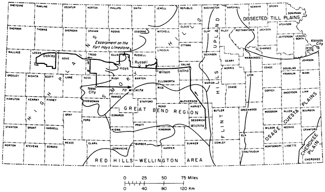
The Smoky Hills (figure 1) are composed of rocks belonging mainly to the Dakota Formation and lower part of the Colorado Group (table 1). The eastern half of the section is characterized by hilly topography developed on shale and sandstone units of Cretaceous rocks older than the Greenhorn Limestone. Prominent hills are held up by sandstone bodies within the stratigraphically complex Dakota Formation. The distinctive topographic aspect of this part of the section prompted Schoewe (1949) to restrict use of the name "Smoky Hills" thereto and to use the term "Blue Hills" for the western part of the section. Along the route of this excursion the most conspicuous development of Smoky Hills (restricted) topography is in the vicinity of STOPS 1 to 3.
The western half of the Smoky Hills section is bounded on the east by an escarpment capped by Greenhorn Limestone and on the west by the much bolder Fort Hays escarpment. Both features are most prominent along the Saline and Smoky Hill rivers and manifest progressively diminished relief away from these major stream courses. Upland topography is relatively flat where underlain by the upper part of the Greenhorn Limestone or lower part of the Carlile Shale, but toward the western edge of the Smoky Hills steep slopes and local badlands are developed on younger parts of the Carlile in bluffs, buttes, and small mesas capped by the Fort Hays Limestone Member.
In the part of the Smoky Hills section that we will see, maximum relief is near 300 feet (91 m) along the Saline River and 150 feet (48 m) along the Smoky Hill River. Terraces underlain by Pleistocene alluvium are preserved along major stream courses and some tributaries, but are more conspicuous in the valley of Smoky Hill River. The upland surface is thinly veneered by Pleistocene loess.
West of the Fort Hays escarpment the High Plains section is underlain by Pierre Shale, Niobrara Chalk, Ogallala Formation, and various deposits of Pleistocene age (table 1). The uplands are, in general, monotonously flat owing largely to a widely distributed but discontinuous veneer of loess laid down during three episodes of eolian deposition that occurred during the Illinoian and Wisconsinan stages. Bedrock formations of Pliocene and Cretaceous age are exposed locally in the upland areas. Thousands of shallow depressions that dot the upland surface of the High Plains have been the subject of much discussion in the literature and have been attributed to the activity of buffaloes, wind, solution, compaction, and silt infiltration (Frye and Leonard, 1952, p. 203). In the western part of the region that we will cross during the second day, bedrock beneath the upland surface is largely that of the Ogallala Formation; farther east on the second-day route this formation is thin, patchy, or absent, and Niobrara beds form nearly all of the upland bedrock.
In the area of this trip, the High Plains surface is slashed by eastward- to southeastward-flowing streams of the Smoky Hill River drainage basin. The Smoky Hill River valley is 15 miles or more wide where it cuts into soft deposits of the Smoky Hill Chalk Member and Pierre Shale in Gove and Logan counties. The inner valley, including low-level, late Pleistocene terraces and Recent floodplain, ranges in width from 1/4 to 1 mile. In Logan and Gove counties, the outer parts of the valleys are characterized in many places by broad streamward-sloping, debris-veneered erosional surfaces that Frye and Leonard (1952, p. 27) called "flanking pediments." These surfaces are steepest at the valley edges, just below the upland margin, and downslope they flatten until they are nearly horizontal toward the inner valley, where they may merge with high-level terrace deposits (Johnson, 1958; Hodson and Wahl, 1960, p. 13). Cretaceous rocks crop out in bluffs that separate these terrace deposits and the inner valley, and also in areas where the outer valley slopes are not protected by flanking-pediment veneer. Exposures of the Smoky Hill Chalk Member are particularly susceptible to erosion by rain wash and streams and in a number of places this unit has been carved into badlands with steep-walled canyons, natural bridges, and slender pinnacles. Where dissection of the upper parts of valley slopes has exposed lithified Ogallala beds that underlie the upland surface, that formation holds up steep cliffs.
During the afternoon of the second day, we will cross the eastern edge of the High Plains in an area where the Ogallala Formation has been stripped by erosion from all but the highest divides, where the unit remains as thin, discontinuous remnants nearly to the crest of the Fort Hays escarpment. Most of the area is underlain by the Smoky Hill, which is thinly veneered by Pleistocene loess. Upland areas underlain by Ogallala deposits are generally flatter than those underlain by Cretaceous rocks.
Following final retreat of the Western Interior Sea, Cretaceous rocks in western Kansas were truncated during an erosional interval that produced, just prior to inception of Miocene-Pliocene deposition, broad plains of low relief across which drainage was generally eastward in the field-trip area (Johnson, 1958, p. 28; Frye and Leonard, 1952, p. 185). Major uplift in the Rocky Mountains region brought a flood of detritus that filled valleys and buried divides beneath a complex of coalescent alluvial plains; these deposits leveled the existing topography and formed the monotonous topography that remains little modified in undissected areas of the High Plains.
In the field-trip area, Pleistocene erosion and alluviation along Smoky Hill River resulted in the formation of terrace deposits at three major levels. The following summary of Pleistocene events in the area of the field trip is drawn from the work of Frye and Leonard (1952), Leonard and Berry (1961), and Bayne and Fent (1963).
Moderate initial dissection of the High Plains occurred during the Pleistocene Nebraskan Stage, during which time the streams deposited alluvium now preserved as a terrace remnant lying as much as 140 feet (46 m) below Pliocene deposits in the Smoky Hills of Russell and Ellis counties. Deep downcutting during Kansan time resulted in alluviation along channels now preserved beneath Illinoian sediments on a surface known as the Pfeifer Terrace, which lies 30 to 40 feet (9.2 to 12.2 m) above the present floodplain in eastern Trego and western Ellis counties. This terrace has been traced from Ellsworth County, in the Smoky Hills, to as far west as Logan County in the High Plains. East of central Ellis County the Kansan deposits occur as a separate terrace and lie topographically above Illinoian terrace deposits. Kansan deposits occur also along Saline River valley in Ellis, Russell, and Lincoln counties. Valley broadening in Illinoian time is reflected in widespread sand, gravel, and silt deposits that form the surface of the Pfeifer Terrace. Remnants of a terrace of the same age are preserved along Saline River valley to the north. Until Illinoian time, water of Saline and Smoky Hill rivers in the field-trip area drained southeastwardly from the area, not into the Kansas River as at present. Headward erosion of the latter stream captured the upper reaches of the southeastwardly draining system and Saline and Smoky Hill rivers became integrated as a part of the Kansas River drainage basin. Renewed downcutting and alluviation during the Wisconsinan Stage produced low river terraces that are situated below the Illinoian terrace and lie only a few feet above the modern floodplain. Post-Wisconsinan changes include cutting of the present river channels into Wisconsinan deposits or Cretaceous bedrock, and development of the narrow floodplain.
Widespread deposition of loess during the Illinoian and Wisconsinan Stages has irregularly veneered the uplands, flanking pediments along stream courses, and older terraces; thus masking the relationships among these features in some areas and contributing to the extreme flatness of the High Plains surface.
Structural dip at the top of the Dakota Formation is approximately 7 feet (2.1 m) per mile to the northeast in the easternmost portion of the field-trip area, increasing westward in Ellis and Trego counties to approximately 10 feet (3.1 m) per mile to the north or slightly east of north. Still farther to the west, in Gove County, the dip is approximately 13 feet (4 m) per mile to the north and increases further to approximately 20 feet (6 m) per mile to the northeast in Logan County (see Merriam, 1957b). Major structural features reflected at this datum in western Kansas include, from east to west, the Salina basin, Cambridge arch, Western Kansas basin, and the eastern flank of the Las Animas arch (figure 2). According to Merriam (1963) the Salina basin and Cambridge arch are largely inherited from an earlier structural framework; the Western Kansas basin is a Mesozoic feature; and the Las Animas arch in Kansas is largely a post-Cretaceous feature. The Cambridge arch lies outside the area of this field excursion. Paleozoic structures in the area that are not reflected at the top of the Dakota include the Central Kansas uplift, which underlies our route in Ellsworth, Russell, Ellis, and Trego counties, and the Hugoton embayment which embraces all of Kansas west of the Cambridge arch and Central Kansas uplift (Merriam, 1963, p. 178).
Figure 2--Major structural features reflected in Cretaceous rocks in the field-trip area. Named minor structures are: (1) Fairport-Natoma anticline, (2) Pfeifer anticline, (3) Alanthus dome, (4) Hell Creek anticline, (5) Elkader dome, (6) Twin Buttes anticline, (7) Chalk Creek dome, (8) Ellsworth-Kanopolis anticline. Adapted from Merriam (1963).
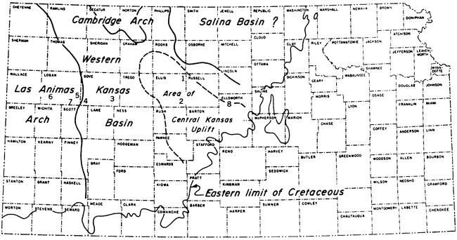
Named minor structures expressed in Cretaceous rocks in the field-trip area include the asymmetrical Fairport-Natoma anticline in northeastern Ellis County; the Pfeifer anticline of southeastern Ellis County, aligned with the Fairport-Natoma structure; Alanthus dome in southeastern Gove County; the domelike Hell Creek structure in southern Gove, southeastern Logan and northeastern Scott counties; Elkader dome in southeastern Logan County; Chalk Creek Dome in southern Logan County; and Twin Buttes anticline in southwestern Logan County (Lupton and others, 1922; Jewett, 1951). Merriam (1963) also included the Ellsworth-Kanopolis anticline of northwestern Ellsworth County among minor structures reflected in Cretaceous rocks. The regional dip of the Cretaceous is further modified by numerous unnamed minor anticlines, synclines, and other structures which have been described by Lupton and others (1922), Rubey and Bass (1925), Bass (1926), Elias (1931), and Johnson (1958).
On a smaller scale, hundreds of normal faults that are best expressed in the Niobrara Chalk occur also in the Carlile and Pierre shales. In a small area of northwestern Ellis County, Bass (1926, p. 44) mapped 76 faults, nearly all of which are in the Smoky Hill Chalk Member. Maximum displacement observed by Bass was 80 feet (24.4 m) and the greatest length of trace among these faults was less than half a mile (one kilometer). Johnson (1958, p. 30) believed that displacement along similar faults in Logan County might exceed 200 feet (60 m) and mapped the trace of one fault, or closely spaced set of faults, that is nearly 3 1/2 miles (5.6 km) in length. The Pierre Shale lies in fault contact with the Niobrara Chalk in a number of areas in Logan and Gove counties. Most of the faults in the field-trip area have dips of 45° ± 10°, although some are nearly vertical, and are marked by coarsely crystalline masses of slickensided calcite that may be as much as 4 to 8 inches (10 to 20 cm) in thickness; but brecciation has occurred along some fault planes. Dip on beds directly adjacent to such faults was found to be as high as 15° by Johnson (1958, p. 30) and 19° by Bass (1926, p. 45). These faults are not believed to be related to regional structure.
In contrast to Cretaceous rocks, the Miocene/Pliocene Ogallala Formation is deformed only locally (Elias, 1931). Structure at the top of the "algal limestone" marking the top of the formation is characterized by "monotonously uniform east dip, which reflects none of the major structural features in western Kansas" and averages approximately 15 feet (4.6 m) between the Colorado state line and Mitchell and Lincoln counties (Merriam, 1963, p. 197).
Classification and characteristics of stratigraphic units that crop out in the field-trip area are summarized in table 1. Along the valley of Smoky Hill River and its western tributaries, exposed Upper Cretaceous marine rocks reach an aggregate thickness of approximately 1,670 feet (590 m). Of this thickness, about 600 feet (183 m) are dark-gray noncalcareous shale belonging to the incompletely exposed Pierre Shale. The Colorado Group (Graneros Shale, Greenhorn Limestone, Carlile Shale, Niobrara Chalk) is approximately 1,060 feet (324 m) thick, of which 80% is limestone and chalk, 18.8% is dark-gray non-calcareous shale, 0.5% is quartzose sandstone and siltstone, and approximately 0.7% is bentonite. Sandstone locally comprising the uppermost 5 feet (1.5 m) of the Dakota Formation is probably also of marine origin. Along Saline River valley, the Colorado Group is approximately 995 feet (303 m) thick, of which 74.5% is limestone and chalk, 21.6% is noncalcareous shale, a maximum of 3.1% is sandstone and siltstone, and approximately 0.8% is bentonite. In addition, at least 30 feet (9.2 m) of sandstone in the upper part of the Dakota Formation are locally of marine origin.
Table 1--Stratigraphic units in field-trip area.
| System | Series | Stage | Formation | Member | Thickness (meters) |
Lithology | Topographic expression |
|---|---|---|---|---|---|---|---|
| Neogene | Pleistocene | Recent | Alluvium | 0-21.4 | Silt, sand, gravel | Present channel and flood pain; surface of lowest terrace. | |
| unconformity | |||||||
| Wisconsinan | a. Low terrace deposits b. Bignell (Brady) soil) c. Peoria |
a. 0-30.5 b. 0-8.2 c. 0-15.3 |
Silt, sand, gravel Loess Loess |
Low terrace lying approximately 4.6 to 6.1 m. above Smoky Hill and Saline Rivers. Thin mantle on upland Thin mantle on upland |
|||
| unconformity | |||||||
| Illinoian | (Sangamon soil) Loveland |
(measured with c. above) | Loess; laminated sand and silt | Thin mantle on upland gradng laterally into stream-laid deposits in upper part of Kansan-Illinoian high-terrace complex. | |||
| Crete | 0-19.8 | Sand and gravel | Widely distributed in dissected Kansan-Illinoian high-terrace complex. | ||||
| unconformity | |||||||
| Kansan | Sappa | 0-13.7 | Silt and sandy silt with lenses of sand, gravel, and volcanic ash (Pearlette ash bed) | Channel deposits truncated by overlying Illinoian deposits in high-terrace complex. | |||
| Grand Island |
0-10.7 | Sand and gravel | Basal part of channel deposit underlying the high-terrace complex. | ||||
| unconformity | |||||||
| Nebraskan | Holdredge Fullerton |
0-12 | Gravel, sand, silt, clay | Channel deposits lying high on valley walls or on divides between major streams in Ellsworth, Russell and Ellis counties. | |||
| unconformity | |||||||
| Miocene / Pliocene |
Ogallala | 0-69 | Chiefly sand, with clay, silt, and gravel; in part lime-cemented to form "Mortar beds," in part cemented with silica to form "quartzite." Also contains some chert, bentonitic clay, volcanic ash, and limestone. | Loess-mantled cap rock of upland surface of High Plains. Outlying remnants cap divides in highly dissected areas. Exposed in steep bluffs and cliffs at upland margin along larger stream courses. | |||
| unconformity | |||||||
| Cretaceous | Gulfian | Campanian | Pierre Shale |
Weskan Shale |
53 | Dark-gray shale with clay-ironstone and limestone concretions, phosphate nodules, and bentonite. | Canyons and slopes in valleys of larger streams; local badlands. |
| Sharon Springs Shale |
47 | Dark-gay shale, organic-rich in upper part, with phosphate nodules, limestone concretions, calcareous septarian concretions, and many thin seams of bentonite. | Canyons and slopes in valleys of larger streams; commonly forms badlands. | ||||
| Coniacian- Santonian |
Niobrara Chalk | Smoky Hill Chalk |
171-189 | Olive-gray shaly chalk mostly weathering grayish orange and yellowish gray; many thin seams of bentonite. Where intensely weathered lacks shaly structure and forms resistant cap rock. | Canyons and badlands along valley walls of larger strems and small tributaries. Many rock pinnacles and monuments. | ||
| Turonian | Fort Hays Limestone |
17-23 | Light-olive-gray chalky limestone, mostly weathering pale grayish orange, yellowish gray, or nearly white. | Cliffs along valley walls of large streams. Cap rock on buttes, mesas, and low bluffs. | |||
| unconformity | |||||||
| Carlile Shale |
Codell Sandstone |
0-9.5 | Light-olive-gray quartzose sandstone and siltstone, commonly streaked with shale, locally calcareous. | Lower part of cliffs held up by Fort Hays Member. Locally absent or too thin to be expressed physiographically. | |||
| Blue Hill Shale |
51.2-56.4 | Dark-gray shale, very silty near top, with numerous zones of calcareous concretions and one or two zones of clay-ironstone concretions. | Gullied lower slopes of Fort Hays escarpment; slopes of buttes and mesas capped by outliers of Fort Hays Member. | ||||
| Fairport Chalk |
27.5-36 | Olive-gray laminated shaly chalk with numerous beds of chalky limestone and marly chalk, and seam of bentonite. Lower part generally weathered yellowish gray to grayish orange. | Lower part typically underlies upland plain in western part of Smoky Hills. Along larger stream courses, especially near the Fort Hays escarpment, member forms steep slopes and precipitous cutbanks. Local badlands. | ||||
| Greenhorn Limestone |
Pfeifer Shale |
6.4 | Olive-gray to olive-black shaly chalk and chalky, commonly nodular or concretionary limestone; generally weathered yellowish gray to pale grayish orange. | Steep slopes, and locally cliffs, along valleys of larger streams. | |||
| Jetmore Chalk |
6.1-6.4 | Olive-gray to olive-black shaly chalk and chalky limestone, the latter commonly weathered yellowish gray to pale grayish orange. | Cliffs and steep bluffs along courses of larger streams. | ||||
| Cenomanian | Hartland Shale | 8.8-10.7 | Olive-gray to olive-black shaly chalk with scattered beds of chalk and chalky limestone and several conspicuous beds of bentonite. | Upper part: steep slopes below cliffs and bluffs held up by Jetmore Member. Lower part: gentle slopes, poorly exposed. | |||
| Lincoln Limestone |
6.4-7.6 | Olive-black shaly chalk, light-olive-gray to olive-gray chalk or chalky limestone, pale-yellowish-brown skeletal limestone and numerous seam of bentonite. Basal bed commonly conglomeratic. | Upper part: gentle slopes, poorly exposed. Lower part: cutbanks and cliffs along courses of large and some small streams. | ||||
| unconformity | |||||||
| Graneros Shale |
7.6-11 | Dark-gray shale, quartzose sandstone, skeletal lmestone, with a 0.3-m-thick bentonite bed near top. | Gentle grass-covered slopes. Best exposed in cutbanks along courses of larger streams. | ||||
| Dakota Formation |
Janssen Clay |
about 15.3 |
Dark-gray silty carbonaceous shale, quartzose sandstone and siltstone, lignite, and mudstone. | Steep grass-covered but commonly gullied slopes, low bluffs, local badlands. | |||
Cretaceous strata were truncated regionally by pre-Miocene erosion, then buried beneath Ogallala deposits which, at one place or another in the state, rest directly on every one of the Cretaceous formations. Pleistocene and Recent deposits rest on Cretaceous rocks in many places, especially along the valleys of larger streams where post-Pliocene erosion removed the widespread mantle of Ogallala sediments.
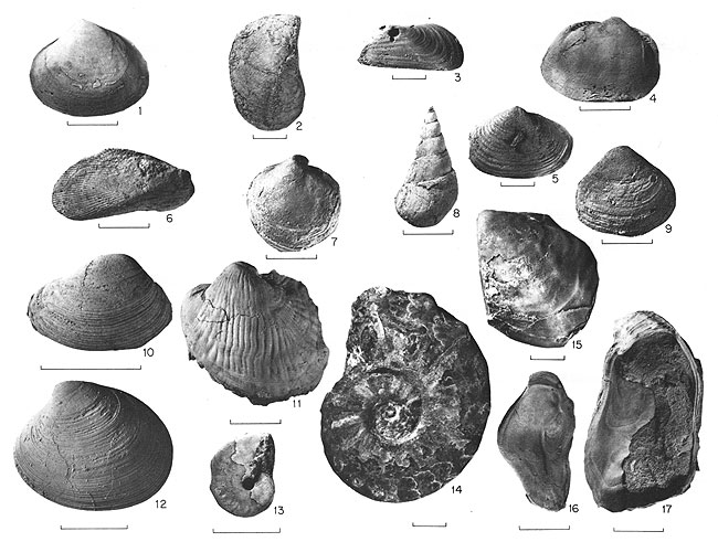
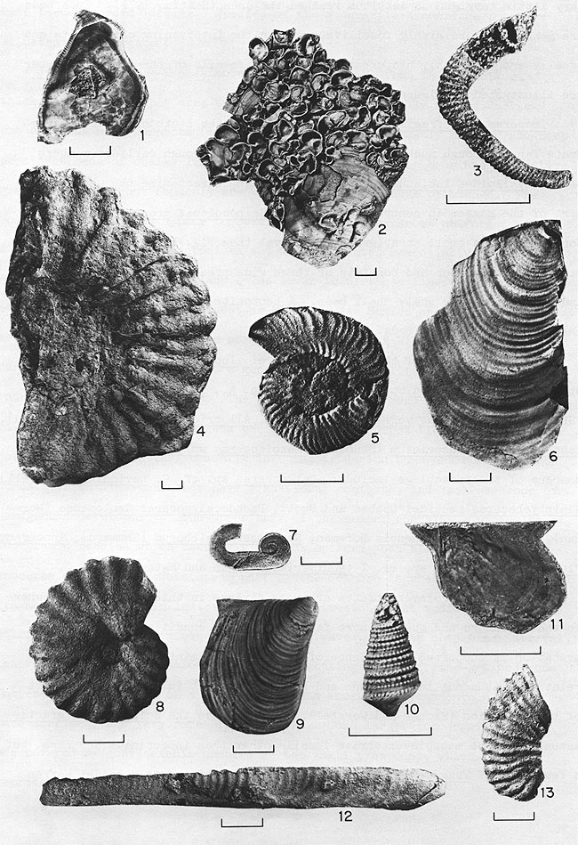
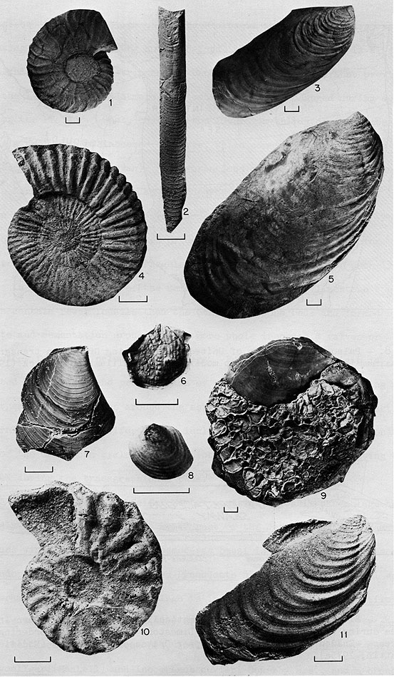
Common macroinvertebrate fossils in Upper Cretaceous marine units of western Kansas are illustrated in figures 5-7, 10 and 11.
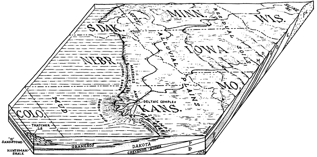
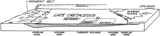
The Dakota Formation is 200 to 300 feet (60 to 90 m) thick in the western half of Kansas and crops out extensively in the central and north-central part of the state; however, only the upper 100-150 feet (30 to 46 m) of the Dakota is exposed along the field-trip route. Although Dakota rocks are composed predominantly of nonmarine, variegated mudstones and channel sandstone lenses, sedimentary deposits within the upper 30-40 feet (9.2 to 12.2 m) exposed in Russell County represent a transition from the nonmarine deposits below to the shallow-water marine deposits of the Graneros Shale above. These transitional deposits record deposition in an environmentally diverse, deltaic and marginal marine setting during initial stages of the transgressive phase of the Greenhorn marine cycle (figure 3).
Figure 3--Paleogeographic reconstruction representing central Kansas and adjacent areas during deposition of the upper part of the Dakota Formation and lower part of the Graneros Shale (from Hattin, 1967, p. 587).
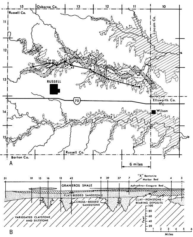
Several major facies of the upper part of the Dakota have been delineated by Hattin (1956b) and Siemers (1971, 1976). The six major facies of Siemers (1971) are: 1) variegated nonmarine mudstones with thin siltstone and sandstone lenses, 2) crossbedded, elongate-trough-shaped fluvial sandstone bodies, 3) flat-bedded, elongate-tabular-shaped sandstone bodies, 4) lignite-bearing deposits, 5) sideritic clay-ironstone-bearing deposits, and 6) thin bioturbated and fossiliferous marine sandstone and shale beds near the top of the formation. The general relationships of some of the facies (which will be examined during the field trip) are illustrated in figure 4.
Figure 4--Locality map and east-west cross section of sedimentary facies in upper part of Dakota Formation, Russell County, Kansas. A. Dakota outcrop shown by ruled pattern; higher Cretaceous units (mostly Graneros and Greenhorn) lie in non-patterned area. Approximate position of "latest" stage of channel sand deposition of Rocktown channel sandstone shown by the stippled area. Positions of measured sections used in construction of the cross-section shown below (figure 4B) indicated by numbered dots. (Map modified from Rubey and Bass, 1925, pl. III). B. Major sedimentary facies in upper part of Dakota Formation exposed in Saline River valley area. Crossbedded channel sandstone body is crossed several times by section owing to meandering pattern of Rocktown channel sandstone. The flat-bedded sandstone subfacies shows an anomalously extensive occurrence owing to trend of cross section, which parallels approximate trend of sandstone body. Datum for section is "X" bentonite seam near top of Graneros Shale.
The major features of these facies and their interpretation are as follows:
Variegated mudstones with thin siltstone and sandstone lenses. The main lithologies of this lithofacies are: a) blocky, kaolinite mudstone and claystone, b) carbonaceous, blocky to shaly mudstone and claystone, and c) laminated clayey siltstone and thin lenses of laminated to cross-laminated sandstone. The mudstones and claystones are light greenish gray with yellowish to reddish-, greenish- and brownish-colored mottles, probably resulting from the oxidation of siderite spherulites. The carbonaceous shaly beds form distinct dark-gray beds in many outcrops. Chief fossils are plant remains, mainly leaves of deciduous trees. Terriginous concretionary structures called "rhizocretions," which form around the rhizomes and trunks of woody plants, are present locally. Burrow structures are conspicuously absent; only a single Planolites-like burrow was observed in this facies. The facies represents fluviatile overbank deposits including probable shallow lacustrine and ephemeral swamp deposition.
Crossbedded, elongate-trough-shaped fluvial sandstone bodies. These sandstones, along with those of Facies 3, have been discussed at length by Siemers (1976). The friable, yellowish-gray to orange-colored, trough crossbedded sandstone is very well sorted and fine grained. Strongly unimodal paleocurrent patterns are characteristic. Body fossils and trace fossils are conspicuous by their absence: plant debris is common but generally abraded and oxidized. Sandstone bodies are sinuous, elongate, broadly trough-shaped bodies as much as 59-72 feet (18-22 m) thick and 980 to 1,970 feet (300-600 m) wide, and at least one sandstone body (the Rocktown channel sandstone) has been mapped over a distance of nearly 30 miles (50 km). These sands are underlain by or pass laterally into the variegated mudstones of Facies 1 and usually are overlain by the flat-bedded sandstone of Facies 3. This sandstone facies represents active fill of fluvial channels; locally, the upper channel-fill is fine-grained carbonaceous sediment representing abandoned inactive-channel fill.
Flat-bedded, elongate-tabular-shaped sandstone bodies. The laminated and ripple-bedded, very-fine grained, well-sorted sandstones of this facies occur in units which cap the channel sandstones of Facies 2, and extend laterally to overlie mudstones. of Facies 1 and in some areas rocks of Facies 4 and 5. Sandstone bodies are 20 to 30 feet (6 to 9 m) thick and 2,950 to 4,920 feet (900 to 1500 m) wide. Paleocurrent patterns are bimodal to polymodal. Trace fossils including Planolites, Skolithos, Arenicolites, and Chondrites are common. A brackish-water macroinvertebrate association dominated by Corbicula sp. and Serpula sp. was collected from these sandstones. This facies appears to represent late-stage sand deposition in delta distributaries and deposition of reworked sands during the Graneros transgression (figure 3).
Lignite-bearing deposits. Lithologies of this facies include matted, ash-rich, lignite seams interbedded with carbonaceous shales and thin, discontinuous laminated beds of very fine-grained sandstone, which contain numerous vertical to sub-vertical reed-mold plant structures. This facies generally overlies mudstones of Facies 1 and grades upward into the Graneros Shale. Fossils are scarce, but include arenaceous foraminifera (Hattin, 1965a, b) in addition to the abundant plant debris and upright reed molds in the sandstone and siltstone beds. Siemers (1971) interprets this facies as the deposits of fresh- to brackish-water swamps in a fluvial deltaic setting, whereas Hattin (1965b, 1977) suggests that these beds represent deposition in lagoons and adjacent marshes near the seaward margin of a coastal delta or along a nearby linear clastic shoreline.
Sideritic, clay-ironstone-bearing deposits. The main lithofacies of this facies are: a) iron-stained, olive-gray to olive-black sandy shale, b) bioturbated ferruginous, siderite-cemented sandstone beds, and c) burrowed, thin sideritic clay ironstone seams and concretionary layers. Rocks of this facies occur in broad lens-like to sheet-like bodies that overlie variegated mudstones of Facies 1 or flat-bedded sandstones of Facies 3 and grade upward into the Graneros Shale. Laterally the clay-ironstone facies appears to be adjacent mainly to Facies 3 sandstone units. Internally, the facies varies slightly in the abundance of siderite bands and in the type and abundance of body fossils and trace fossils. Where thin siderite seams are abundant they contain burrow structures such as Planolites, Polyupsilon, Arenicolites and Rhizocorallium, and macroinvertebrates are mainly the marginal marine mussel Brachidontes arlingtonanus Stephenson, oyster Ostrea sp. and annelid Serpula sp. Where bioturbated ferruginous sandstone beds are the main lithology, trace fossils are mainly Planolites, Thalassinoides and Teichichnus, and the macroinvertebrates are represented by a more fully marine association including the mussel Brachidontes (mainly B. filisculptus microcostae Stephenson), oyster Crassostrea soleniscus (Meek), and several bivalves including species of Breviarca, Cymbophora, Geltena, Laternula, Parmicorbula, Tellina and Volsella. This facies appears to represent a range of depositional environments from brackish-water interdistributary bay to marginal marine near-shore areas affected by nearby deltaic sedimentation.
Thin, bioturbated and fossiliferous sandstone and shale. These moderately well-sorted, fine- to very fine-grained sandstones are laminated to ripple bedded and may contain abundant marine macroinvertebrate fossils and numerous trace fossil taxa. The sandy shales are relatively more abundant than in Facies 3. The facies occurs between underlying nonmarine and marginal-marine strata below and overlying marine strata and the Graneros Shale. Trace fossils include Ophiomorpha, Thalassinoides, Skolithos, Planolites, Chondrites, Arenicolites and Polyupsilon, and the marine macroinvertebrate association, including the mussel Brachidontes, oyster Crassostrea and numerous bivalves (see list for Facies 5 above), is well represented. These sands and shales represent near-shore-marine to shallow-marine environments.
The variability of lithofacies such as observed in the upper part of the Dakota Formation in central Kansas is typical of a deltaic setting, which in this case has been preserved by a blanket of transgressive marine shale. The several distinct macroinvertebrate fossil associations (four recognized by Siemers, 1971) range from brackish-water to fully marine groups and relate well to the lithofacies. Trace-fossil abundance and diversity also correlate well with the lithofacies and body-fossil associations. Nonmarine and fluvial-deltaic facies (Facies 1, 2, and 4) contain few biogenic structures, except for reed molds and rhizocretions; however, marginal marine facies (Facies 3 and 5) contain a greater variety of trace fossils and marine sands and shale (Facies 6) contain the greatest abundance and variety of trace fossils. Selected macroinvertebrate species of the Dakota Formation are illustrated in figure 5.
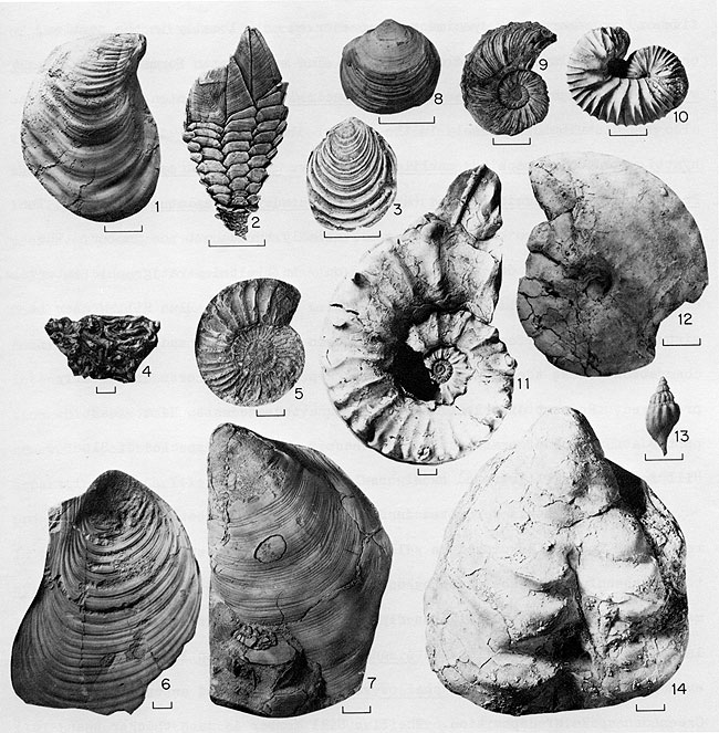
Figure 5--Representative species of macroinvertebrate fossils of the Dakota Formation (1-9) and Graneros Shale (10-17) in the field-trip area. Bar scales equal 1 cm. 1, Geltena subcompressa Stephenson, inflated form; 2, Crassostrea soleniscus (Meek); 3, Volsella tarrantana Stephenson; 4, Breviarca (Sanoarca) grandis (Stephenson); 5, Laternula virgata Stephenson; 6, Brachidontes filisculptus microcostae Stephenson; 7, Exogyra cf. E. levis Stephenson; 8, Anchura sp. G. of Stephenson (1952); 9, Cymbophora spooneri Stephenson; 10, Parmicorbula? hillensis Stephenson; 11, Exogyra columbella Meek; 12, Aphrondina lamarensis (Shumard); 13, Borissiakoceras reesidei Morrow; 14, Acanthoceras amphibolum Morrow; 15, Inoceramus rutherfordi Warren; 16-17, Ostrea beloiti Logan.
The nonuniform position of the Dakota-Graneros contact, as determined by reference to marker beds, reflects intertonguing of adjacent parts of the two units. Complexly varied lithology in the upper part of the Dakota gives way upward to more uniform lithology in the lower part of the Graneros Shale. Everywhere in central Kansas, facies succession through the Dakota-Graneros transition suggests stratigraphically upward replacement of nonmarine and marginal-marine environments by broadly uniform, open-marine conditions. In some sections the sequence suggests transgression across linear clastic shorelines involving the marsh, shore lagoon and barrier beach-shoreface environments. Other sections suggest spread of the open-marine environment across a delta platform, with Graneros shales, silts and sands succeeding Dakota sediments of delta-front bars, drowned distributaries, interdistributary bays, or marshes.
In the immediate vicinity of the field-trip route, the Graneros Shale ranges from 24.9 to 36.4 feet (7.6 to 11.1 m) in thickness, averaging 31.5 feet (9.6 m) for nine complete sections in Russell, Ellsworth, and Lincoln counties. The lower part of the formation consists mainly of dark-gray silty-clay shale that is irregularly interlaminated with silt and fine sand and contains a few to several beds of thin-bedded, commonly cross-laminated, well-sorted, mostly noncalcareous quartzose sandstone. Concentrations of bone pebbles occur locally. Starved ripples, cross laminations and small-scale sole markings are common evidence of current action, especially near the middle of the formation. Distribution and abundance of sand, silt, carbonaceous debris, and local bone beds suggest that deposition could have occurred in both outer delta platform-delta slope and in lower shoreface-offshore environments, depending upon whether the shoreline was deltaic or linear. Local shell conglomerate, extensive thin sand bodies enclosed in shale, and local bone beds all suggest reworking of a predominantly muddy bottom under shallow-water conditions. Near absence of calcareous beds, absence of ammonites, dominance of arenaceous foraminifers, rarity of planktonic foraminifers, and occurrence of Lingula in the lower part of the Graneros Shale all suggest brackish water that probably resulted from river discharge. The most common macroinvertebrates in this part of the formation are Aphrondina lamarensis (Shumard) and Exogyra columbella Meek; the strata have been assigned to the "Callistina lamarensis Assemblage Zone" by Hattin (1965a). The sparse fauna probably reflects inaccurately the original diversity of lower Graneros communities. In most beds only one or two species are represented but an unusual coquina lens in southwestern Russell County includes, in addition to the common species, several forms not preserved elsewhere in the Graneros of Kansas: Lispodesthes sp. cf. L. patula Stephenson, Ringicula sp., Fustiaria (Laevidentalium) sp., and various unidentified bivalve molds.
The upper part of the Graneros comprises dark-gray silty-clay shale that commonly includes a few to several thin beds of calcareous sandstone in the lower part and thin beds of skeletal limestone in the upper part. The shale is weakly calcareous locally. Ripple marks and cross laminations are common features of the calcareous sandstone beds, and bone-pebble conglomerate is known locally. The X-bentonite marker bed lies near the top of the Graneros at most localities (Hattin, 1965a; 1968). Upward increase in number of planktonic foraminifers and appearance of ammonites in the upper part of the Graneros and the general increase in calcium carbonate content of the rocks suggest that salinity increased progressively as Graneros deposition proceeded. Carbonaceous matter and quartzose sand and silt are generally less abundant than in the lower part of the formation, reflecting decreased deltaic influence during deposition of the upper part of the Graneros. These beds are broadly analogous to bottomset beds of modern deltas or to the offshore muds of modern linear clastic shorelines. Chief macroinvertebrates in upper Graneros strata are Ostrea beloiti Logan, Acanthoceras amphibolum Morrow, Inoceramus rutherfordi Warren, and Borissiakoceras reesidei Morrow. Dominance of the first of these prompted Hattin (1965a) to assign these beds to the O. beloiti Assemblage Zone. At some localities oysters are concentrated in thin biostrome-like beds, many of which are actually current-accumulated shell hash set in calcarenite matrix. Fossils of the Graneros Shale are illustrated in Figure 5.
Basal beds of the Lincoln Member consist generally of crossbedded and cross-laminated skeletal, and locally conglomeratic limestone that lies with sharp stratigraphic contact and abrupt lithologic contrast upon beds of the Ostrea beloiti Assemblage Zone across much of Kansas. At the southern end of the central Kansas outcrop, however, these basal Lincoln strata lie on older beds of the Aphrondina lamarensis Assemblage Zone defining a regional unconformity. The unconformity separating the Graneros and Greenhorn formations has been shown to be diachronous (Hattin, 1968) and usually involves omission of one assemblage zone. At this stratigraphic break, nondeposition and local erosion of the upper part of the Graneros was followed by renewed deposition in a shallow-water zone of considerable turbulence that gave rise to relatively coarse-grained skeletal rocks that form the base of the Lincoln Member. Diachroneity of the contact and development of skeletal grainstones directly above it resulted from eastward to northeastward migration across the area of an offshore high energy belt (Shaw, 1964; Irwin, 1965) that shifted laterally during the transgressive half of the Greenhorn marine depositional cycle. Ostrea beloiti is locally concentrated in great numbers in the basal Lincoln beds, and Exogyra columbella, possibly reworked from the lower part of the Graneros, occurs sparingly. Molds of ammonites, probably including Calycoceras canitaurinum (Haas), Dunveganoceras sp. cf. D. pondi Hass, and Stomohamites sp. cf. S. simplex d'Orbigny occur locally in the basal Greenhorn. These beds mark the first occurrence in Kansas of Inoceramus prefragilis Stephenson, which is host locally to Exogyra aff. E. boveyensis Bergquist, characterized by its small size and broad attachment surface.
Initial turbulence during early Greenhorn deposition gave way to quieter conditions far from the eastern shoreline, and beds of laminated olive-black chalk accumulated under conditions generally unfavorable to bottom-dwelling infauna or epifauna. Scattered flattened valves of I. prefragilis, molds of the small ammonites Eucalycoceras sp. and Desmoceras (s.l.) sp., and, in one locality, excellently preserved Stramentum moorei Hattin, comprise nearly the entire fauna in the middle part of the Lincoln. Over much of central Kansas, Lincoln deposition terminated with accumulation of a zone of skeletal limestone lenses composed chiefly of remains of Inoceramus and probably representing a brief return to depths shallow enough to permit occasional reworking of bottom deposits by wave action. Concentration of debris originally scattered widely through the sediment resulted from this renewed turbulence. Inoceramus prefragilis is the only common macroinvertebrate species in these beds. Species referable to Inoceramus ginternesis Pergament occur sparsely in middle and upper parts of the Lincoln Member. Selected Lincoln species are illustrated in Figure 6. In Kansas, the Lincoln Member has an average thickness of 23 feet (7 m).
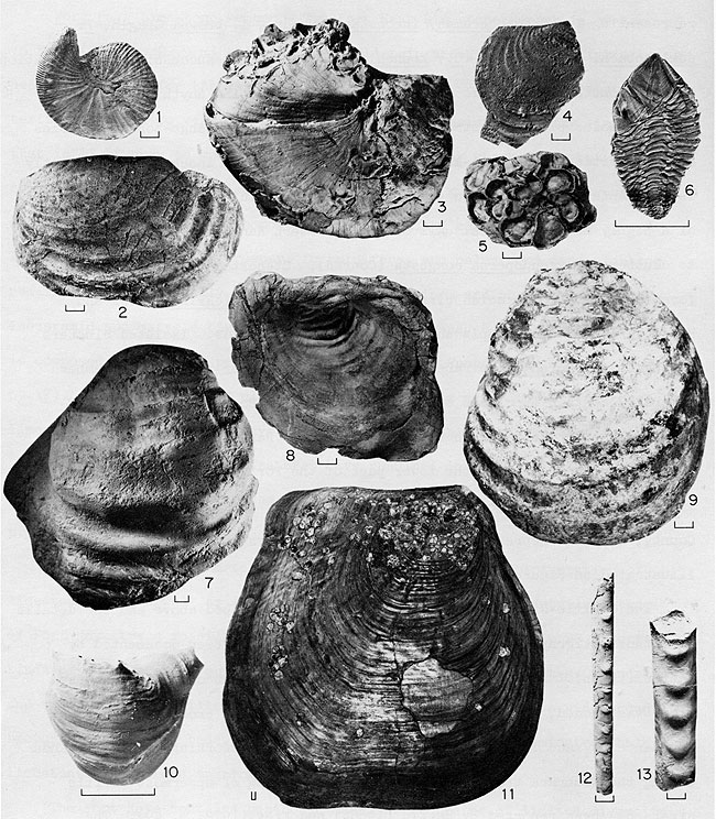
Figure 6--Representative species of macroinvertebrate fossils from the Lincoln (1-6) and Hartland (7-13) Members of the Greenhorn Limestone in the field-trip area. Bar scales equal 1 cm. 1, Ostrea beloiti Logan; 2, Exogyra sp. aff. E. boveyensis Bergquist; 3, Stomohamites sp. cf. S. simplex (d'Orbigny); 4, Calycoceras canitaurinum (Haas); 5, Eucalycoceras sp. B of Hattin (1975a); 6, Inoceramus prefragilis Stephenson; 7, Worthoceras vermiculum (Shumard); 8, Metoicoceras whitei Hyatt; 9, Inoceramus pictus Sowerby; 10, Cerithiella sp. A of Hattin (1975a); 11, Phelopteria sp. A of Hattin (1975a); 12, Sciponoceras gracile (Shumard); 13, Pseudocalycoceras dentonense (Moreman).
This member consists dominantly of laminated olive-black chalk with scattered beds of lighter colored, burrow-mottled chalky limestone as much as 0.9 foot (0.27 m) thick and several beds of bentonite. Some of the chalky limestone beds are demonstrably time parallel because they maintain a uniform relationship to marker bentonites. Four of these bentonite beds are traceable throughout the Kansas outcrop and westward to the southern Rocky Mountains of Colorado and New Mexico. The member is 29 to 32 feet (8.8 to 9.8 m) thick in the field trip area. During Hartland deposition, environmental conditions were generally inhospitable to benthonic forms of life, possibly owing to the highly fluid substrates, to the smothering effect of fine-grained sediment, to poor circulation, or to all of these factors. The burrow-mottled chalky limestone beds are believed to have accumulated during periods of slower sedimentation when very little terrigenous detritus reached the area (Hattin, 1971). Such beds are generally more richly fossiliferous than the intervening chalk units and usually are thoroughly bioturbated. Selected fossils of the Hartland Member are illustrated in figure 6.
Inoceramus prefragilis Stephenson dominated the benthonic macroinvertebrate fauna through much of Hartland deposition, although earliest members of the Mytiloides labiatus (Schlotheim) lineage characterize the uppermost part of the member in central Kansas. The Sciponoceras gracile Assemblage Zone occupies a small stratigraphic interval (see figure 18) lying below the middle of the member and consists of three widespread chalky limestone beds and the intervening chalky-shale beds. A bentonite marker bed lies between the first two of these beds.
Major components of this assemblage are: Inoceramus pictus Sowerby, Phelopteria sp. A, Cerithiella sp. A., Sciponoceras gracile (Shumard), Worthoceras vermiculum (Shumard), Allocrioceras annulatum (Shumard), Kanabiceras septemseriatum (Shumard), Metoicoceras geslinianum d'Obigny. Less common members of the assemblage include: Calycoceras sp. cf. C. naviculare (Mantell), Hemiptychoceras reesidei Cobban and Scott, Pseudocalycoceras dentonense (Moreman), Scaphites brittonensis Moreman, and Worthoceras gibbosum (Shumard).
Benthonic macroinvertebrates are more diverse in this zone than elsewhere in the Greenhorn and suggest more favorable bottom conditions. This interpretation is supported by evidence of benthonic foraminifers, which are relatively abundant in this zone and sparse or absent in the remaining part of the formation (Eicher and Worstell, 1970). Above the Sciponoceras gracile Assemblage Zone macroinvertebrate fossils other than inoceramids are rare, but a few molds of Tragodesmoceras bassi Morrow and Watinoceras cf. W. reesidei Warren have been recorded locally. Species of the S. gravile Assemblage Zone are illustrated in figure 6.
The Jetmore Chalk is 20 to 21 feet (6.1 to 6.4 m) thick in the field-trip area and is similar lithologically to the Hartland but contains more numerous (13), more closely spaced, mostly thicker and more prominent beds of chalky limestone. The chalky-limestone beds are dark-olive gray where fresh but commonly are weathered to some shade of orange. The chalky-limestone beds appear to be time parallel because of uniform position with respect to marker bentonites and were generated essentially in the same manner as those in the Hartland. The lower 10 of these limestone beds can be traced as far to the southwest as El Vado, New Mexico and the upper four are recognizable as far to the northwest as the Black Hills. As in the Hartland, the limestone beds are generally more fossiliferous than the intervening chalky-shale beds. The conspicuously burrowed character of nearly all of these limestones suggests periods of slower deposition that favored development of an extensive mobile infauna, producing numerous burrow structures. These limestone beds have mostly gradational contacts and lack evidence of hardground development. The upper half of the member contains a profusion of inoceramid remains which seemingly reflect optimum conditions for growth of inoceramid bivalves. This part of the Jetmore is characterized by shell fragments and very thin lenses of skeletal limestone that indicate occasional stirring of bottom sediments by currents or waves. During this time interval, generally better circulation and reduced settling rates of fine-grained muds fostered establishment of a limited epifauna including Pycnodonte kansasense Bottjer, Roberts, and Hattin, rare cirripeds and very rare Discinisca sp. Some larger inoceramid valves are covered by considerable numbers of the small pycnodont, which is best represented between the 9th and 10th beds of chalky limestone.
The Jetmore stratigraphic interval embracing the first six chalky-limestone beds is characterized by Watinoceras cf. W. reesidei Warren and inoceramids of the Mytiloides labiatus (Schlotheim) lineage. Less common forms include Baculites sp. cf. B. yokoyamai Tokunaga and Shimizu, Tragodesmoceras bassi Morrow, Discinisca sp., and Anomia sp. The remainder of the member is characterized by Mytiloides mytiloides (Mantell), Mammites nodosoides (Schlütter), Tragodesmoceras bassi Morrow, and Baculites cf. B. yokoyamai Tokunaga and Shimizu. Selected Jetmore species are illustrated in Figure 7.
Figure 7--Representative species of macroinvertebrate fossils from the Jetmore (1-6) and Pfeifer (7-11) Members of the Greenhorn Limestone. Bar scales equal 1 cm. 1, Tragodesmoceras bassi Morrow; 2, Baculites cf. B. yokoyamai Tokunaga and Shimizu; 3, 5, Mytiloides mytiloides (Mantell); 4, Watinoceras cf. W. reesidei Warren; 6, Pycnodonte kansasense Bottjer, Roberts, and Hattin; 7, Inoceramus cuvieri Sowerby s.s.; 8, Anomia sp. A of Hattin (1975a); 9, Pseudoperna bentonensis (Logan) on a valve of I. cuvieri; 10, Collignoniceras woollgari (Mantell); 11, Mytiloides mytiloides (Mantell) trans. to M. subhercynicus (Seitz).
The Jetmore Member of central Kansas represents far offshore shelf deposition approximately at the peak of transgression during the Greenhorn cycle of sedimentation, at depths probably between 300 to 600 feet (90 and 180 m). These beds contain less terrigenous detritus than the beds below (Hattin, 1971) and suggest even greater distance to the shorelines than during Hartland deposition (Figs. 8 and 9).
Figure 8--Paleogeographic map of United States during Greenhorn transgressional maximum (early Turonian). Map modified from Williams and Stelck (1975).
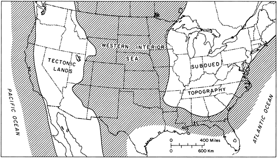
Figure 9--Block diagram depicting schematically a portion of Western Interior Sea during deposition of Greenhorn Limestone and nature of bordering land areas. Shaded portion indicates Upper Cretaceous sediments (Modified from Hattin, 1975a).
The Pfeifer consists chiefly of chalky shale and chalky limestone but differs from the Jetmore in having numerous irregular, discontinuous, shell-rich concretionary beds of chalky limestone (lower 2/3) or layers of oblate spheroidal chalky limestone concretions (upper 1/3). Flat chalky limestone beds, including the Fencepost limestone bed at the top, are scattered through the member and are believed to be time parallel because of consistent relationships to Pfeifer bentonite markers. The flat beds of limestone have some traces of bioturbation and are believed to have originated in the same manner as those in the Jetmore. Significance of the Fencepost bed to early settlement of the Plains is the subject of a fascinating book by Muilenburg and Swineford (1975). The Pfeifer is 21 feet (6.4 m) thick in the field-trip area. Depositional conditions that prevailed during the latter half of Jetmore time continued little changed during accumulation of the Pfeifer. Shaly chalk in the lower two-thirds of the member contains a profusion of inoceramid valves, which commonly host specimens of Pseudoperna bentonensis (Logan). Concentrations of shelly debris and the presence here of epizoans such as Pseudoperna and scalpellid cirripeds suggests that the sea floor was swept irregularly by bottom currents. The layers of shelly debris were sites of concretionary addition of calcium carbonate, which explains the irregular shape and distribution of such limestones. In the upper third of the member, layers of chalky-limestone concretions contain fewer fossils than the other limestone beds and formed by carbonate-mud cementation around one or more whole inoceramid valves or around other fossils, including large logs. Early diagenetic origin is manifested by in-the-round preservation of contained fossils and bending of adjacent shaly chalk layers around the concretions as a result of compaction. In central Kansas, the Pfeifer Member includes some of the purest carbonate strata of the Greenhorn depositional cycle and is interpreted as having been deposited during the transgressional peak.
The lower third of the Pfeifer Member contains a fossil assemblage that is broadly similar to that in the upper part of the Jetmore Member. However, Mammites nodosoides is absent, Tragodesmoceras bassi is questionably represented and Pseudoperna bentonensis replaces Pycnodonte kansasense as the principal epizoan on inoceramid valves. This assemblage is in the upper part of the Mytiloides mytiloides Range Zone. The remainder of the Pfeifer, from bed 46 of figure 18 through the Fencepost limestone bed, contains the first specimens of Collignoniceras woollgari (Mantell) and Inoceramus cuvieri Sowerby s.s., and a broad form of the M. labiatus lineage that is referable to M. subhercynicus (Seitz). A sparse fauna of epizoans includes Pseudoperna bentonensis and two species of stalked cirripeds. Selected Pfeifer species are illustrated in figure 7. The lithostratigraphy, biostratigraphy, sedimentary petrology, and depositional environment of this and other members of the Greenhorn Limestone in Kansas have been treated extensively by Hattin (1975a).
Although the Fairport Member has been classified historically as a member of the Carlile, the unit is genetically related, both faunally and lithologically, to the Greenhorn Limestone. Furthermore, the lowermost part of the Fairport is indistinguishable from the Pfeifer Shale Member of the Greenhorn, suggesting need for upward shift of the existing Pfeifer-Fairport boundary. Additionally, the Fairport fulfills all qualifications for formational status and is, therefore, inappropriately ranked as a member (Hattin, 1962, p. 20). In the area of this field trip, the Fairport ranges from 90 to 118 feet (27.5 to 36 m) in thickness.
The Fairport consists chiefly of olive gray to dark-olive-gray chalk with beds of chalky limestone in the lower part and beds of marlstone in the middle and upper parts. Lenses of skeletal limestone composed largely of inoceramid bivalve debris are scattered throughout the middle and upper parts. Terrigenous detritus constitutes as little as 15% of the shaly chalk, increasing to as much as 50% of the rock in the uppermost part of the member. As in the Greenhorn Limestone, many of the widespread layers of chalky limestone and marlstone of the Fairport have a uniform relationship to marker bentonites across the west-central Kansas outcrop and are thus believed to be essentially time parallel. Variations in the rate of terrigenous detritus against a gradually diminishing "background" accumulation of carbonate mud is responsible both for the alternation of chalky limestone and chalky shale in the lower part of the member and the increasingly impure carbonate strata stratigraphically upward in the member. Clearly, the Fairport reflects deposition during regressive movement of the closest shoreline. Following a period of almost no wave or current impingement on the sea floor during latest Pfeifer and early Fairport deposition, wave or current action swept the bottom regularly during later Fairport time and concentrated skeletal debris into the abundant lenses that now characterize middle and upper parts of the member.
In the lower part of the Fairport the only common benthonic macroinvertebrates are Inoceramus cuvieri Sowerby s.s. (throughout) and (in ascending order) Mytiloides subhercynicus (Seitz), M. hercynicus (Petrascheck) and M. "latus" (sowerby) (sensu Hattin, 1962). The first of these reached very large size and commonly hosted clusters of Pseudoperna bentonensis. In this part of the section substrates were highly fluid and circulation was probably poor, just as in parts of the Greenhorn that lack evidence of current or wave activity; at any one horizon diversity of benthonic organisms was correspondingly low.
Parts of the Fairport containing abundance of skeletal limestone lenses (i.e., middle and upper parts of the member except for the uppermost few feet) represent better circulation of bottom waters and probably shallower depths. Here is developed, for these chalky-carbonate strata, a relatively diverse suite of epizoans, including Pseudoperna bentonensis in enormous numbers, Serpula tenuicarinata Meek and Hayden, Stramentum elegans Hattin and two species of bryozoans. These epizoans are mostly attached to large valves of Inoceramus cuvieri, or to one another. Their number reflect clearly improved circulation in the benthic environment and sufficient removal of settling mud to permit growth of several epizoan generations. The uppermost few feet of the member lack skeletal limestones and diverse epizoans and the benthonic fauna is dominated by a sulcate inoceramid, Inoceramus n. sp. aff. I. flaccidus White.
Fairport cephalopods include the ubiquitous Collignoniceras woollgari, sparse Scaphites patulus Cobban extending through the upper three-fourths of the member, and very rare specimens of Actinocamax manitobensis (Whiteaves) below the middle of the Fairport. From a high level in the Jetmore, diversity and abundance of planktonic foraminifers decreases irregularly upward through the Fairport Member (Eicher and Worstell, 1970, p. 276). Some common Fairport species are illustrated in Figure 10.
Figure 10--Representative species of macroinvertebrate fossils from the Fairport (1-7) and Blue Hill (8-14) Members of the Carlile Shale in the fieldtrip area. Bar scales equal 1 cm. 1, Inoceramus n. sp. aff. I. flaccidus White; 2, Stramentum elegans Hattin; 3, Mytiloides "latus" (Sowerby) (sensu Hattin, 1962); 4, Serpula tenuicarinata Meek and Hayden; 5, Collignoniceras woollgari (Mantell); 6, Mytiloides subhercynicus (Seitz); 7, Inoceramus cuvieri Sowerby s.s.; 8, "Lucina" juvenis Stanton; 9, Prionocyclus hyatti (Stanton); 10, Scaphites carlilensis Morrow; 11, Prionocyclus hyatti (Stanton); 12, Proplacenticeras pseudoplacenta (Hyatt); 13, Bellifusus willistoni (Logan); 14, Inoceramus flaccidus White.
The Blue Hill Shale Member ranges in thickness from 168 to 185 feet (51 to 56 m) in the field-trip area. The member consists chiefly of dark-gray silty-clay shale that weathers flaky and is sandy near the top. Zones of septarian limestone concretions characterize most of the member and clay-ironstone concretions occur in two zones in the lower half of the unit. Fine-grained noncalcareous sediment in the Blue Hill represents influx of terrigenous detritus associated with regression of the Greenhorn depositional cycle; this regression is first reflected in the increase in land-derived sediment in the upper part of the Fairport. Blue Hill lithology and the low diversity of benthonic forms suggests turbid water and a soft mud bottom that was inhospitable to most bottom-dwelling forms. The most successful benthonic macroinvertebrates were large platter-shaped specimens of Inoceramus cuvieri, which are common in the lower part of the member, and Inoceramus flaccidus White, which possessed greatly inflated valves dorsally and coarse concentric rugae that apparently were adaptations to a reclining life habit on highly fluid substrates. These inoceramids commonly hosted small numbers of ostreid bivalves, possibly Pseudoperna bentonensis. Gastropods are represented by five or six genera, but specimens are preserved only locally in the section, especially in clay-ironstone concretions. The most common forms are Bellifusus willistoni (Logan) and Tessarolax sp. "Lucina" juvenis Stanton and Yoldia spp. also are distributed sparsely in the member. Ammonites include Prionocyclus hyatti (Stanton), Scaphites carlilensis Morrow, Scaphites arcadiensis Moreman, Proplacenticeras pseudoplacenta (Hyatt), and Binneyites aplatus (Morrow). The first two species are known to range essentially throughout the member. The remaining ammonite species are preserved only in limited stratigraphic intervals, especially near the middle of the Blue Hill. Most of the Blue Hill Member is virtually devoid of fossils, but in some thin shale units, and in certain concretion zones, the fauna is abundantly represented and even beautifully preserved. Present distribution of the fauna thus seems to be at least partly a function of preservational processes. Selected species of Blue Hill fossils are illustrated in Figure 10.
The Blue Hill was deposited during continuation of the long slow regression that is displayed so well in the Fairport Member. Towards the top of the Blue Hill the quantity of terrigenous sand and silt increases markedly, small-scale oscillation ripple marks have been recorded in cross-laminated siltstone, and fish-tooth conglomerates are known locally. This evidence heralds the onset of shallow water conditions and an end to the Greenhorn cycle of deposition. The Blue Hill Member is much thicker than the Graneros Shale, but has much the same stratigraphic distribution of lithotypes as the latter unit, only in the reverse order of occurrence. The Greenhorn cyclothem is remarkably symmetrical in central Kansas.
In the field-trip area the Codell ranges from 5.7 to 31 feet (1.7 to 9.5 m), but over much of northern Kansas it is less than 1 foot (0.3 m) thick. At some localities in the southern part of the west-central Kansas outcrop, the Codell is not recognizable. The member is gradational vertically and laterally with upper beds of the Blue Hill. The Codell consists mostly of well-sorted fine quartzose sand and coarse quartzose silt. it contains small quantities of feldspar and a limited suite of stable heavy minerals. Silty shale occurs in the Codell in some sections. At most localities, the Codell is extensively bioturbated. Well-defined bedding or crossbedding is preserved only locally. Fossils are rare and preserved poorly in west-central Kansas, consisting of a few shark teeth, clam molds and a small foraminiferal assemblage dominated by arenaceous species. Codell sediments represent return to the central Kansas area of shallow-water conditions during general retreat of the sea along the eastern shoreline. Intensive bioturbation of the sands in most sections suggests slow sedimentation which was followed ultimately by a long period of non-deposition; renewed deposition began with the Niobrara cycle of sedimentation. The lacuna separating the Carlile and Niobrara has been shown (Hattin, 1975b) to expand progressively from westernmost Kansas northeastward to northeastern Nebraska. In the former area the youngest Carlile fossils are from the zone of Prinonocylcus wyomingensis Meek and the oldest Niobrara fossils are from the zone of Inoceramus erectus Meek. In northeastern Nebraska, youngest Carlile fossils are from the zone of Collignoniceras woollgari (Mantell) and the oldest Niobrara fossils are from the zone of Volviceramus grandis (Conrad). Hattin (1975b) has shown that the top of the Carlile and base of the Niobrara are diachronous, and also that the major facies of the two formations have diachronous contacts. In northeastern Nebraska, sea-floor scour has removed any trace of the Codell so that basal beds of the Fort Hays Member lie in sharp contact with noncalcareous shale of the Blue Hill Member.
The Fort Hays Limestone Member is 55 to 75 feet (16.8 to 22.9 m) thick in the field-trip area, the latter figure being near the maximum for the west-central Kansas outcrop. The unit is characterized by thick to very thick beds of relatively resistant chalky limestone that is light gray to medium gray or light olive gray where fresh but more commonly weathered yellowish gray, grayish or pale grayish orange, or nearly white. The rock is mostly homogeneous micrograined carbonate rock composed largely of micrite and microspar, foraminifera, and calcareous nanoplankton remains, but with locally abundant Inoceramus prisms and shell fragments of inoceramid and ostreid bivalves. Except for the sandy basal bed, the rock is composed of 88-98% calcium carbonate (Runnels and Dibins, 1949, p. 17). Very thin beds of clayey chalk of bentonite separate many of the limestone beds. Most Fort Hays beds have uniform thickness for considerable distances, but channel-like features have resulted in local thickening of beds, especially at or near the base of the member (Hattin, 1965b; Frey, 1972, p. 49).
The Fort Hays is characterized throughout by thorough bioturbation of limestone beds as well as shaly partings. In a thorough and detailed study of Fort Hays trace fossils, Frey (1970) recognized approximately 20 discrete kinds of burrows among which such forms as Teichichnus, Planolites, Chondrites, and various mineral-filled burrows are the most common. Despite widespread bioturbation of most beds, thinly laminated to gently cross-laminated chalky limestone is recorded sparingly in the member.
The Fort Hays contains benthonic macroinvertebrates of limited diversity consisting principally of large, more-or-less bowl-shaped, relatively thick-shelled inoceramids. In westernmost Kansas, lower beds of the Fort Hays contain Inoceramus erectus Meek, but in the field excursion area the oldest undoubted zone is that of I. deformis Meek. Upward in the section forms representing I. (Cremnoceramus) inconstans (Woods), I. browni Cragin, I. schloenbachi Böhm, and I. (C.) koeneni Müller appear in succession, but gradation between some of these forms and difficulty of collecting anything other than internal molds places constraints on exact placement of range-zone boundaries at this writing. The bowl-like shape of most Fort Hays inoceramids apparently is an adaptation for life on substrates that were fluidized by intense activity of a highly mobile infauna. All of these western Kansas species are host to clusters of Pseudoperna congesta (Conrad). Ctenostomatous bryozoa, sessile foraminifera, acrothoracian cirripeds, and Serpula tenicarinata Meek and Hayden are less common epizoans on the large inoceramids. Isolated clusters of the rudist Durania are rare in the Fort Hays. Lower beds of the member generally contain specimens of Pycnodonte aucella (Roemer), regardless of the inoceramid zone to which those beds belong. Rare specimens of Lopha falcata (Morton) occur in the lower part of the Fort Hays locally (Miller, 1968, p. 33) and the species has been collected by the writer in Hamilton County, Kansas. Representative species of Fort Hays macroinvertebrates are illustrated on Figure 11.
Figure 11--Representative species of macroinvertebrate fossils from the Niobrara Chalk (1-11) and Pierre Shale (12, 13). Bar scales equal 1 cm. 1, Clioscaphites choteauensis Cobban; 2, Inoceramus (Cremnoceramus) inconstans Woods; 3, Inoceramus (C?) koeneni Müller; 4, Inoceramus (Endocostea) balticus Böhm; 5, Pseudoperna congesta (Conrad); 6, Stramentum haworthi (Williston); 7, Inoceramus browni Cragin; 8, Volviceramus grandis (Conrad); 9, Inoceramus deformis Meek; 10, Pycnodonte aucella (Roemer); 11, Inoceramus (Platyceramus) platinus Logan; 12-13, Baculites asperiformis Meek. Figures of B. asperiformis furnished by W.A. Cobban; figure of I. (P.) platinus courtesy of Myrl V. Walker.
The Carlile-Niobrara unconformity has been described above and the details of lithostratigraphy adjacent to the unconformity have been documented by Hattin (1975b). During regression that produced this unconformity, the sea floor was eroded, but unequivocal evidence of subaerial erosion is lacking. Abundance of sand in the basal Fort Hays represents reworking of Codell sands during the Niobrara transgression. Local channeling of uppermost Carlile strata has been reported by Hattin (1965b) and Frey (1972, p. 49). The regionally differing nature of uppermost Carlile strata between westernmost Kansas and northeastern Nebraska reflects variation in duration and/or intensity of sea-floor scour that helped to produce the northeastwardly widening lacuna described by Hattin (1975b). Following a prolonged interval of nondeposition and sea-floor scour, renewed subsidence or eustatic sea-level rise once again permitted permanent sediments to accumulate on the broad, flat eastern shelf of the Western Interior Sea. However, the eastern shoreline was so remote that terrigenous detrital influx was small. Thus, relatively pure, far offshore carbonates comprise initial deposits of the second Late Cretaceous sedimentary cycle in Kansas.
Frey (1970) concluded that Fort Hays deposition occurred slowly in well-circulated, gradually deepening waters and that the sediment remained soft and yielding until late in diagenesis. Current action, manifest in channel-like features, cross-laminations, and local skeletal limestone lenses occurred only during the deposition of the lower part of the member. By the time Smoky Hill deposition commenced, the sea was deeper and the bottom waters less well aerated than during accumulation of the lower Fort Hays sediments. The Fort Hays-Smoky Hill contact has been shown by Hattin (1975b) to be diachronous toward the northeast and this diachroneity is borne out by lithostratigraphic and biostratigraphic relations along the same contact in the Pueblo area of Colorado (Scott and Cobban, 1964).
The Smoky Hill Chalk member ranges approximately from 560 to 620 feet (171 to 189 m) in thickness in the field-trip area. The unit is dominated by light-olive-gray to olive-gray chalky shale that is speckled by nearly white spheroidal calcareous fecal pellets (Hattin, 1975c). The pellets are composed almost exclusively of coccoliths. The chalky shale is commonly weathered grayish orange to pale yellowish orange, or dark yellowish orange or very pale yellowish orange, or yellowish gray. During intense weathering the rock loses its obvious bedding features and becomes harder and more massive. Most of the rock is more or less evenly laminated but scattered through the member are thin zones of bioturbated chalk or tough, granular, non-laminated chalk that form prominent markers, especially on little-weathered slopes. The thickest interval of granular chalk is equivalent to the middle chalk unit of Scott and Cobban (1964). This is the hard, lichen-splotched caprock on many erosional pinnacles and promontories in highly eroded areas of the Smoky Hill outcrop. Massive, weathered beds of other stratigraphic intervals locally hold up steep cliffs near the summits of many bluffs. Beds of massive chalk near the base, middle, and top of the Kansas section are correlative with the lower limestone, middle limestone, and upper chalk units recognized at Pueblo, Colorado by Scott and Cobban (1964). Bentonite seams are prominent features of the member and can be used to construct Smoky Hill composite sections (Hattin, 1976).
Smoky Hill strata contain epifaunal benthonic invertebrate communities of low diversity. This, combined with the paucity of bioturbated zones suggest that Smoky Hill waters were deeper and less well-circulated than thsoe in which the Fort Hays sediments were deposited. Principal substrates for attachment of epizoans consisted of large, heavy-shelled, bowl-shaped and giant-sized, platter-shaped species of inoceramids. Volviceramus grandis (Conrad) represents the first of these growth forms and is usually encrusted heavily by one or more generations of Pseudoperna congesta (Conrad). This form ranges through the lower 164 feet (50 m) of the member. A nearly smooth early form of Inoceramus (Platyceramus) platinus Logan, I. (Cladoceramus) undulatoplicatus Roemer, and I. (P.) platinus s.s. occur successively in the member and because of their snowshoe shape are admirably adapted to maintaining position on watery and oozy substrates. All of these species are host to P. congesta, with heavy encrustations occurring commonly on the exterior surfaces of both valves in paired specimens. This phenomenon parallels that seen among large specimens of I. cuvieri in the Fairport Member of the Carlile Shale. The only other nearly ubiquitous benthonic invertebrates were acrothoracican cirripeds. Less common, smaller inoceramids include, in ascending order of occurrence, I. (P.) cycloides Wegner, I. (Endocostea) balticus Böhm, and I. (E.) simpsoni Meek. These forms do not usually host large numbers of epizoal oysters. Cephalopods are conspicuous in the Smoky Hill only in certain intervals. The common forms are Clioscaphites vermiformis (Meek and Hayden), C. choteauensis Cobban, and a large, smooth unnamed species of Baculites. The last of these commonly hosts a few specimens of epizoal P. congesta. Stramentum haworthi (Williston) is a common epizoan locally on specimens of C. choteauensis and Baculites sp. and occurs sparingly on I. (P.) platinus and rarely on P. congesta. Rudists of the genus Durania are scattered through most of the member. These usually hosted a small epizoal fauna consisting of P. congesta, acrothoracicans, and, rarely, lepadomorph cirripeds. Rare cuttlefish, belemnites, and free-swimming crinoids were other elements of the nektonic fauna during Smoky Hill deposition. The crinoids apparently occur in local, very thin lenses in the zone of C. choteauensis. The foraminiferal fauna is dominated by planktonic species. A detailed listing of Smoky Hill species was compiled by Miller (1968). Representative species of Smoky Hill macroinvertebrates are illustrated in Figure 11.
In a general way the lithology and faunal makeup of the member can be compared with that of the Fairport Member of the Carlile Shale. Each unit represents the regressive carbonate phase of the respective depositional cycle, but the Smoky Hill lacks the profusion of skeletal limestone lenses so characteristic of the Fairport.
The Smoky Hill Member is renowned for its content of marine vertebrate fossils. Species of mosasaurs, plesiosaurs, giant turtles, pterosaurs, birds, teleosts, and sharks are the principal forms and abound in some parts of the section. Fish preserved inside larger fish, bones found in coprolites, teeth of shell-crushing sharks, and teeth marks found on invertebrate shells are the kinds of evidence that can be used to reconstruct details of food webs in the faunas that occupied this part of the Western Interior Sea.
Deposition of Smoky Hill sediments was relatively rapid, at least in the less pure chalks that lack bioturbation. Tall, cone-shaped specimens of Pseudoperna congesta, found in the same beds with short, encrusting forms, apparently were attached to small shell fragments. The form is assumed to reflect rapid upward growth that was necessary to prevent burial as the substrate sank into watery or oozy mud. Oysters attached to baculitids are nearly all small, suggesting growth on empty conchs that were buried shortly after attachment of epizoans. The same is true of Stramentum haworthi that are attached to Clioscaphites choteauensis. Inoceramus valves encrusted by large numbers of oyster spat are presumed to have been dead at or soon after the time of epizoic attachment and were buried before the oysters grew very large. In contrast, Inoceramus shells heavily encrusted by thick-shelled adult oysters were alive during oyster growth, and remained unburied for lengthy periods. On such inoceramid valves, second-generation oysters are attached commonly to oysters of earlier generations.
Toward the top of the member, quartz silt becomes increasingly evident in Smoky Hill sediments, and the chalky shale gives way gradually to calcareous shale in the uppermost few feet of the Smoky Hill. A fascinating chapter in Cretaceous history came to an end with the major influx of terrigenous detritus into western Kansas at the advent of Pierre Shale deposition. This sediment reflected approach to western Kansas of the eastern shoreline during a long, slow regressional episode on the eastern shelf of the Western Interior Sea.
[Note: Section on Pierre Shale modified from Cobban, in Hattin (1965b).]
The Pierre Shale crops out only in 7 counties in western Kansas where erosional truncation has reduced original thickness to about 1,400 feet (427 m). The formation consists largely of dark-gray to medium-gray clay shale that contains gray- to brown-weathering limestone concretions, rusty- to dusky-red-weathering ironstone concretions, and numerous thin layers of white or gray bentonite. Elias (1931) described in detail the Wallace County exposures where the lower one-half or less of the Pierre is represented. This part of the Pierre was divided by Elias into four members (ascending): Sharon Springs Shale Member, 155 feet (47.3 m); Weskan Shale Member, 170 feet (51.9 m); Lake Creek Shale Member, 200 feet (61 m); and Salt Grass Shale Member, 60 feet (18.3 m).
The Sharon Springs Shale Member, the type section of which is at McAllaster Buttes, Stop 8, consists of a poorly exposed soft lower part and a well-exposed harder upper part. The lower part, which forms half or more of the member, is a dark-gray soft shale that contains ferruginous concretionary beds and a few thin layers of bentonite. Fossils are scarce; a few of the concretionary beds contain Baculites obtusus Meek and species of Inoceramus and Pteria. This part of the Sharon Springs will not be seen on this excursion. The upper part of the member, which crops out extensively at McAllaster Buttes, is a resistant, organic-rich, buttress-forming brownish-gray shale that contains hard limestone concretions, soft phosphatic concretions, and thin layers of bentonite. The upper part contains a bed of very large, closely spaced septarian limestone concretions which contain thick veins of pale-brown calcite and, less commonly, crystals of barite. Fossils are rare in the upper part of the Sharon Springs although one concretion contained numerous Baculites asperiformis Meek. Vertebrate fossils, including numerous remains of small fish, giant turtles, pleisosaurs, and mosasaurs are common in the Sharon Springs Member. Gill, Cobban and Schultz (1972) have described in detail the lithologic and stratigraphic character of the member in western Kansas.
The Weskan Shale Member consists of soft, dark-gray clayey shale that has numerous concretions and many beds of bentonite, some of which are 0.5 to 1 foot (0.15 to 0.3 m) thick. The lower part contains thin ferruginous concretionary layers and small worm-burrowed phosphatic nodules. The upper part is characterized by many beds of light-gray, hard, dense, limestone concretions. Well-bedded elongated limestone concretions mark the base of the member. The limestone concretions contain species of Inoceramus, Pteria, and Anomia, as well as fragmentary ammonite ramains. The Weskan contains rare, irregular, concretionary masses of Nympholucina-bearing limestone similar to that which comprises teepee buttes in the Pierre Shale of Colorado. Only the basal part of the Weskan is exposed at the McAllaster Buttes.
The Lake Creek Shale Member is a dark-gray, flaky-weathering shale that has many thin concretionary ferruginous layers that impart a rusty appearance to the outcrops. The member contrasts with adjacent members in near absence of large limestone concretions. Baculitids, chiefly B. reesidei Elias, are common. A wide variety of invertebrates, especially species of inceramids, scaphites, and Serpula, were reported by Elias (1931), and remains of large fish and mosasaurs have been recorded from the Lake Creek.
The Salt Grass Shale Member is a gray clay shale containing limestone concretions, thin ferruginous concretions, and a few thin layers of bentonite. Irregular bodies of Nympholucina-bearing limestone occur in the lower and upper parts of the Salt Grass. The most abundant fossil is Baculites eliasi Cobban but several species of scaphites, Inoceramus and other bivalves have been recorded.
The Pierre Shale of western Kansas was deposited several hundred miles from the western shore of the Western Interior Sea and an unknown distance from the eastern shore. The formation is very thin relative to time-equivalent strata farther west in central Colorado. During much of Pierre time, depositional rates were probably slow in Kansas and were especially slow during deposition of zones containing an abundance of phosphatic concretions. Paucity of fossils in many of the rocks may be a reflection of slow deposition, but diagenetic removal of skeletal carbonates probably occurred on a large scale.
Formations in the upper part of the Dakota Formation and lower part of the Colorado Group record deposition during the first Late Cretaceous marine-sedimentation cycle. The stratigraphic succession is an asymmetrical cyclothem composed of nine facied including, in ascending order: (1) flat-bedded sandstone, carbonaceous and commonly clayey siltstone and sandstone, and generally silty and clay-ironstone-bearing gray shale, represented by the uppermost parts of the Dakota Formation; (2) gray, noncalcareous silty or sandy shale with sandstone beds, represented by the lower part of the Graneros Shale; (3) gray, mostly noncalcareous silty shale with beds of calcareous sandstone and skeletal limestone and local septarian concretions, represented by the upper part of the Graneros Shale; (4) dark-olive-gray marly and and chalky shale that contains abundant beds and lenses of skeletal grainstone; (5) dark-olive-gray chalky shale and limestone containing relatively little terrigenous detritus, represented by the Hartland, Jetmore, and Pfeifer members of the Greenhorn Limestone and by the lower parts of the Fairport Chalk Member of the Carlile Shale; (6) dark-olive-gray chalky to marly shale that contains abundant lenses of skeletal grainstone, represented by the upper three-fourths of the Fairport Member, Carlile Shale; (7) gray, noncalcareous silty shale with septarian concretions, represented by most of the Blue Hill Shale Member, Carlile Shale; (8) gray, locally concretionary, noncalcareous silty or sandy shale with thin sandstone beds, represented by the uppermost part of the Blue Hill Shale Member; and (9) siltstone and sandstone, commonly argillaceous, represented by the Codell Sandstone Member of the Carlile. Macroinvertebrate fossils are everywhere abundant only in phases (3) through (7). Further subdivision is unwarranted in the Kansas section, but for equivalent strata farther west in Colorado Kauffman (1967, 1969) has proposed a cyclic model that has several additional phases.
Sequence, sedimentary structures, and fossils in these beds suggest successive, gradational changes from nearshore, shallow, mostly brackish-water environments of deposition in facies (1) and (2) to far offshore deposition in deeper waters of normal or near normal salinity in facies (5) and return to nearer shore, shallower water deposition through phases (7) to (9). The regressional half of the cyclothem is much thicker than the transgressional half.
Cretaceous rock units above the Carlile Shale in western Kansas represent parts of two additional Late Cretaceous cycles of sedimentation in the eastern portion of the Western Interior Sea. Niobrara strata represent maximum transgression (Fort Hays) and initial deposits of a protracted regression (Smoky Hill) that are analogous to facies (5) of the first cyclothem. Basal shales of the Pierre are analogous to facies (7) of that cyclothem. Transgressive rocks of this second cycle of sedimentation are unrepresented in Kansas for reasons outlined in an earlier section of this guidebook but are represented, at least in part, farther to the west and northwest in Colorado and the Black Hills.
The Sharon Springs Shale Member of the Pierre SHale includes an organic-rich interval that represents a third transgressional maximum. Above this interval, clay-rich shales of the Pierre represent an extended period of slow, regressive sedimentation that apparently proceeded, more or less uninterrupted, for the remainder of Pierre deposition and are broadly analogous to facies (7) of the first cyclothem. Regressive facies (8) and (9), if ever deposited in Kansas, have been entirely removed by pre-Miocene erosion. It should be noted that in other regions of the Western Interior, west of Kansas, the Pierre Shale and Fox Hills Sandstone and equivalent beds contain evidence of an additional cycle of sedimentation (Bearpaw cycle) not preserved in Kansas (Weimer, 1960).
Parts of this guidebook prepared by Hattin are based on field work in Kansas supported by the Kansas Geological Survey and on regional studies made possible by the National Science Foundation under Grant DES-75-06542. Siemer's work on the Dakota Formation was accomplished originally as a doctoral study at Indiana University, with grant support from Sigma Xi and The Geological Society of America, and more recently with the support of Cities Service Company. Gary F. Stewart, Oklahoma State University, helped to log the trip route. The graphic section of Pierre Shale at STOP 8 and figures of Baculites asperiformis were furnished by W. A. Cobban, U.S. Geological Survey, who also wrote the original version of the Pierre Shale description (Cobban, in Hattin, 1965b). Technical services for manuscript preparation were furnished by the Department of Geology at Indiana University and by Cities Service Company. To all these individuals and organizations we extend grateful thanks.
Bass, N. W., 1926, Geologic investigations in western Kansas: Kansas Geol. Survey, Bull. 11, pt. 1, p. 1-52. [available online]
Bayne, C. K. and Fent, O. S.,1963, The drainage history of the Upper Kansas River basin: Kansas Acad. Sci., Trans., v. 66, no. 3, p. 363-377.
Darton, N. H., 1904, Comparison of the stratigraphy of the Black Hills, Bighorn Mountains, and Rocky Mountain Front Range: Geol. Soc. America, Bull., v. 15, p. 379-448.
Eicher, D. L., and Worstell, Paula, 1970, Cenomanian and Turonian foraminifera from the Great Plains, United States: Micropaleontology, v. 16, p. 269-324.
Elias, M. K., 1931, The geology of Wallace County, Kansas: Kansas Geol. Survey, Bull. 18, 254 p. [available online]
Franks, P. C., 1975, The transgressive-regressive sequence of the Cretaceous Cheyenne, Kiowa, and Dakota formations of Kansas; in, The Cretaceous System in the Western Interior of North America, W. G. E. Caldwell, ed.: Geol. Assoc. Canada, Spec. Paper 13, p. 469-521.
Franks, P. C., and others, 1959, Cross-stratification, Dakota Sandstone (Cretaceous) Ottawa County, Kansas: Kansas Geol. Survey, Bull. 134, pt. 6, p. 223-238. [available online]
Frey, R. W., 1970, Trace fossils of Fort Hays Limestone Member of Niobrara Chalk (Upper Cretaceous), west-central Kansas: Univ. Kansas, Paleont. Contr., Art. 53 (Cretaceous 2), 41 p. [available online]
Frey, R. W., 1972, Paleoecology and depositional environment of Fort Hays Limestone Member, Niobrara Chalk (Upper Cretaceous), west-central Kansas: Univ. Kansas, Paleont. Contr., Art. 58 (Cretaceous 3), 72 p. [available online]
Frye, J. C., and Leonard, A. B., 1952, Pleistocene geology of Kansas: Kansas Geol. Survey, Bull. 99, 230 p. [available online]
Frye, J. C., and Schoewe, W. H., 1952, The basis for physiographic subdivision of Kansas: Kansas Acad. Sci., Trans., v. 56, no. 2, p. 246-252.
Gilbert, G. K., 1896, The underground water of the Arkansas Valley in eastern Colorado: U.S. Geol. Survey, 17th Ann. Report, pt. 2, p. 551-601.
Gill, J. R., Cobban, W. A., and Schultz, L. C., 1972, Stratigraphy and composition of the Sharon Springs Member of the Pierre Shale in western Kansas: U.S. Geol. Survey, Prof. Paper 728, 50 p. [available online]
Hall, James, and Meek, F. B., 1856, Descriptions of new species of fossils, from the Cretaceous formations of Nebraska, with observations upon Baculites ovatus and B. compressus, and the progressive development of the septa in Baculites, Ammonites, and Scaphites: Am. Acad. Arts and Sci., Mem., n.s., v. 5. p. 379-411.
Hattin, D. E., 1962, Stratigraphy of the Carlile Shale (Upper Cretaceous) in Kansas: Kansas Geol. Survey, Bull. 156, 155 p.
Hattin, D. E., 1964, Cyclic sedimentation in the Colorado Group of west-central Kansas: Kansas Geol. Survey, Bull. 169, p. 205-217. [available online]
Hattin, D. E., 1965a, Stratigraphy of the Graneros Shale (Upper Cretaceous) in central Kansas: Kansas Geol. Survey, Bull. 178, 83 p. [available online]
Hattin, D. E., 1965b, Upper Cretaceous stratigraphy, paleontology, and paleoecology of western Kansas: Geol. Soc. America, Field Conf. Guidebook, Ann. Mtg., Kansas City, Mo., 69 p. (with section on Pierre Shale by W. A. Cobban).
Hattin, D. E., 1967, Stratigraphic and paleoecologic significance of macroinvertebrate fossils in the Dakota Formation (Upper Cretaceous) of Kansas; in, Essays in Paleontology & Stratigraphy, Raymond C. Moore Commemorative Volume: Univ. of Kansas, Dept. of Geology, Special Publications 2, p. 570-589.
Hattin, D. E., 1968, Plesiacanthoceras wyomingense (Reagan) from Graneros Shale and Greenhorn Limestone (Upper Cretaceous) of central Kansas: Jour. Paleontology, v. 42, p. 1084-1090.
Hattin, D. E., 1971, Widespread, synchronously deposited, burrow-mottled limestone beds in Greenhorn Limestone (Upper Cretaceous) of Kansas and southeastern Colorado: Am. Assoc. Petrol. Geologists. Bull., v. 55, p. 412-431.
Hattin, D. E., 1975a, Stratigraphy and depositional environment of Greenhorn Limestone (Upper Cretaceous) of Kansas: Kansas Geol. Survey, Bull. 209, 128 p.
Hattin, D. E., 1975b, Stratigraphic study of the Carlile-Niobrara (Upper Cretaceous) unconformity in Kansas and northeastern Nebraska; in, The Cretaceous System in the Western Interior of North America, W. G. E. Caldwell, ed.: Geol. Assoc. Canada, Spec. Paper No. 13, p. 195-210.
Hattin, D. E., 1975c, Petrology and origin of fecal pellets in Upper Cretaceous strata of Kansas and Saskatchewan: Jour. Sed. Petrology, v. 45, p. 686-696.
Hattin, D. E., 1976, Stratigraphic study of Smoky Hill Chalk Member, Niobrara Chalk (Cretaceous) in the type area: Geol. Soc. America, Abst. with Programs, v. 83 p. 481.
Hattin, D. E., 1977, Upper Cretaceous stratigraphy, paleontology, and paleoecology of western Kansas, with a section on the Pierre Shale by W. A. Cobban: Mountain Geologist, v. 14, p. 175-218.
Hattin, D. E., 1982, Stratigraphy and depositional environment of Smoky Hill Chalk Member, Niobrara Chalk (Upper Cretaceous) of the type area, western Kansas: Kansas Geol. Survey, Bulletin 225, 108 p.
[available online]Hayden, F. V., 1857, Notes explanatory of a map and section illustrating the geological structure of the country bordering on the Missouri River, etc: Philadelphia Acad. Nat. Sci. Proc., v. 9, p. 109-116.
Hayden, F. V., 1872, Sketch of the geological formations along the route of the Union Pacific Railway, Eastern Division; in, Final report of the United States Geological Survey of Nebraska and portions of adjacent territories: U.S. 42d. Cong., 1st Sess., House Exec. Doc. 19, p. 66-69.
Hodson, W. G., and Wahl, K. D., 1960, Geology and ground-water resources of Gove County, Kansas: Kansas Geol. Survey, Bull. 145, 126 p. [available online]
Irwin, M. L., 1965, General theory of epeiric clear water sedimentation: Am. Assoc. Petrol. Geologists, Bull., v. 49, p. 445-459.
Jewett, J. M., 1951, Geologic structures in Kansas: Kansas Geol. Survey, Bull. 90, pt. 6, p. 105-172. [available online]
Johnson, C. R., 1958, Geology and ground-water resources of Logan County, Kansas: Kansas Geol. Survey, Bull. 129, 175 p. [available online]
Kauffman, E. G., 1967, Coloradoan macroinvertebrate assemblages, central Western Interior; in, Paleoenvironments of the Cretaceous seaway--a symposium, E. G. Kauffman and H. C. Kent, eds.: Colorado School of Mines, Golden, May, 1967-preprints of papers, p. 67-143.
Kauffman, E. G., 1969, Cretaceous marine cycles of the Western Interior: Mountain Geologist, v. 6, p. 227-245.
Leonard, A. R., and Berry, D. W., 1961, Geology and ground-water resources of southern Ellis County and parts of Trego and Rush counties, Kansas: Kansas Geol. Survey, Bull. 149, 156 p. [available online]
Logan, W. N., 1899, A discussion and correlation of certain subdivisions of the Colorado formation: Jour. Geology, v. 7, p. 83-91.
Lupton, C. T., and others, 1922, Oil possibilities of western Kansas: Am. Assoc. Petrol. Geologists, Bull., v. 6, p. 69-90.
Meek, F. B., and Hayden, F. V., 1861, Descriptions of new Lower Silurian (Primordial), Jurassic, Cretaceous, and Tertiary fossils, collected in Nebraska, etc.: Philadelphia Acad. Nat. Sci. Proc., v. 13, p. 415-447.
Merriam, D. F., 1957a, Subsurface correlation and stratigraphic relation of rocks of Mesozoic age in Kansas: Kansas Geol. Survey, Oil and Gas Inv. 14, 25 p.
Merriam, D. F., 1957b, Preliminary regional structural contour map on top of the Dakota Formation (Cretaceous) in Kansas: Kansas Geol. Survey, Oil and Gas Inv. 15, map.
Merriam, D. F., 1963, The geologic history of Kansas: Kansas Geol. Survey, Bull. 162, 317 p. [available online]
Merriam, D. F., and others, 1959, Description of a Dakota (Cretaceous) core from Cheyenne County, Kansas: Kansas Geol. Survey, Bull. 134, pt. 1, 104 p. [available online]
Miller, H. W., 1968, Invertebrate fauna and environment of deposition of the Niobrara Formation (Cretaceous) of Kansas: Fort Hays Studies, n.s., Sci. Ser. no. 8, 90 p.
Mudge, B. F., 1875, Geology of Kansas: Kansas State Board of Agriculture: 4th Am. Rept., p. 107-127
Mudge, B. F., 1878, Geology of Kansas: Kansas State Board of Agriculture, 1st Bienn. Rept., p. 46-88.
Muilenburg, Grace, and Swineford, Ada, 1975, Land of the post rock; its origins, history, and people: Lawrence, Kansas, Univ. Kansas Press, 207 p.
Plummer, Norman, and Romary, J. F., 1942, Stratigraphy of the pre-Greenhorn Cretaceous beds of Kansas: Kansas Geol. Survey, Bull. 41, pt. 9, p. 313-348. [available online]
Rubey, W. W., and Bass, N. W., 1925, The geology of Russell County, Kansas: Kansas Geol. Survey, Bull. 10., 86 p. [available online]
Runnels R. T., and Dubins, I.M., 1949, Chemical and petrographic studies of the Fort Hays Chalk in Kansas: Kansas Geol. Survey, Bull. 82, pt. 1, 36 n. [available online]
Schoewe, W. H., 1949, The geography of Kansas, part II, physical geography: Kansas Acad. Sci., Trans., v. 52, no. 3, p. 261-333.
Scholle, P. A., 1977, Chalk diagenesis and its relation to petroleum exploration: oil from chalks, a modern miracle?: Am. Assoc. Petrol. Geologists, Bull., v. 61, p. 982-1009.
Scott, G. R., and Cobban, W. A., 1964, Stratigraphy of the Niobrara Formation at Pueblo, Colorado: U.S. Geol. Survey, Prof. Paper 454-L, 30 p. [available online]
Shaw, A. B., 1964, Time in stratigraphy: New York, McGraw-Hill, 365 p.
Siemers, C. T., 1971, Stratigraphy, paleoecology, and environmental analysis of upper part of Dakota Formation (Cretaceous), central Kansas: unpub. Ph.D. thesis, Indiana University, 287 p.
Siemers, C. T., 1976, Sedimentology of the Rocktown channel sandstone, upper part of the Dakota Formation (Cretaceous), central Kansas: Jour. Sed. Petrology, v. 46, p. 97-123.
State Geological Survey of Kansas, 1964, Geologic map of Kansas: M-1, map.
Swallow, G. C., 1866, Preliminary report of the geological survey of Kansas: Lawrence, 198 p.
Weimer, R. J., 1960, Upper Cretaceous stratigraphy, Rocky Mountain area: Am. Assoc. Petrol. Geologists Bull., v. 44, n. 1-20.
Williams, G. D. and Stelck, C. R., 1975, Speculations on the Cretaceous palaeogeography of North America; in, The Cretaceous System in the Western Interior of North America, W. G. E. Caldwell, ed.: Geol. Assoc. Canada, Spec. Paper 1, p. 1-20.
Williston, S. W., 1893, The Niobrara Cretaceous of western Kansas: Kansas Acad. Sci., Trans., v. 13, p. 107-111.
Kansas Geological Survey, Upper Cretaceous Stratigraphy and Depositional Environments of Western Kansas
Placed on web July 9, 2009; originally published in April 1978 (reprinted 1987).
Comments to webadmin@kgs.ku.edu
The URL for this page is http://www.kgs.ku.edu/Publications/Bulletins/GB3/index.html