Kansas Geological Survey, Guidebook 1, originally published in 1976
Next Page--Road Log and Stratigraphic Sections
Originally published in 1976 as Kansas Geological Survey Guidebook 1.
This publication has been prepared for the 1976 Annual Meeting of the Midwest Friends of the Pleistocene, an informal organization of scientific and professional workers who have active interests in Pleistocene geology of the midwestern part of the United States. Planning and preparation of the guidebook for this Annual Meeting began in early 1973 under the joint sponsorship of the State Geological Survey of Kansas, Dr. Claude W. Hibbard of the University of Michigan and Edwin Gutentag of the U.S. Geological Survey, Garden City, Kansas.
Following the death of Dr. Hibbard in the fall of 1973, the field trip was postponed. This guidebook has been assembled since that time and is an attempt to present the views on the faunal sequence of Meade County and the surrounding area that were held by Dr. Hibbard at the time of his death.
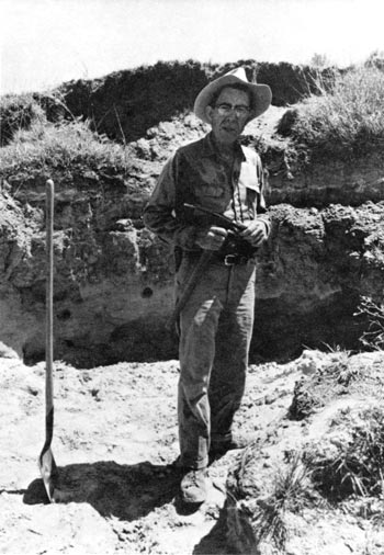
Plate 1--Claude W. Hibbard, March 21, 1905, to October 9, 1973. Geologist, Paleontologist, Teacher, Friend.
Since 1936, Hibbard spent most of the summers with field parties either from the University of Kansas or with parties from the University of Michigan studying the fossils in Meade County and the surrounding areas. Pleistocene deposits in this area in the past have been tentatively assigned to the four glacial and four interglacial stages of the classic Pleistocene classification of central North America.
Presently, there is no general agreement in defining the Pliocene-Pleistocene boundary. Estimates of the placement of this boundary may range from as little as 1.5 m.y. to as much as 3.0 m.y. In the past, the placement of the lower limit of the Pleistocene had been based on the earliest paleontologic evidence of a markedly cooler climate in the mid-latitudes. Placement of the rock units and their contained faunas within this time frame was based in part on whether a particular fauna lived in a cool or warm climate, in part on the evolution of the individual species in the fauna, and on the belief that a discontinuous but widespread volcanic ash (Pearlette) represented a single event occurring in late Kansan time.
Recent work using fission-track radiogenic dating has shown that this ash represented not one but several ash falls ranging in age from 0.6 m.y. to 2.0 m.y. The belief that the Pearlette ash represented a single event has led to the miscorrelation of some rock units and errors in the placement of some faunas within the time frame. Few of the names formerly used for the rock units in the medial and early Pleistocene are valid. This paper presents only our present thinking on the chronology of the faunas within the time frame in the area.
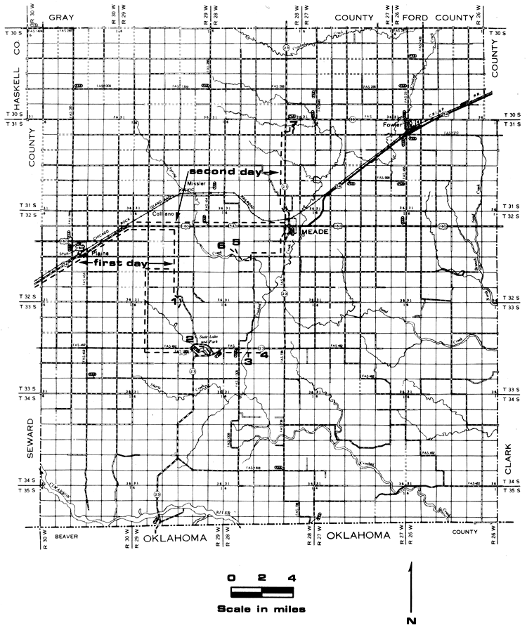
Meade County is located in the southern tier of counties in the state. It is bordered by Oklahoma on the south and lies about 80 miles east of the Colorado border. The county has an area of about 975 square miles and is drained by Cimarron River and its tributaries. Crooked Creek, the principal tributary, drains most of the central and eastern part of the county (fig. 1).
Figure 1--Map of Meade County showing stops.
Meade County lies partly in the High Plains section and partly in the Plains Border section of the Great Plains physiographic province. The topography of the western and northwestern parts of the area which are in the High Plains section are relatively flat and featureless. The southeastern and southern parts of the area are relatively rough and locally present steep slopes. The altitude at Meade, the county seat, is about 2,500 feet. The lowest point in the county is in the valley of Crooked Creek where it crosses the Kansas-Oklahoma State line, where the altitude is near 2,100 feet. The topography rises to near 2,800 feet in the northwest corner of the county.
Originally the High Plains extended much farther to the east but headward erosion of streams and sink hole development and subsequent stream development has moved the edge of the High Plains westward to its present position. Extensive sink hole development in the area east of the present High Plains has played a major role in the physiographic development of this area. Sink hole development probably began in late Pliocene time. The sinks are believed to be associated with the faulting which has occurred in the area. It is believed that faults permitted water to reach the Blaine Salt at a depth of several hundred feet and subsequent circulation of water caused solution of the salt leading to the collapse of overlying beds. Big and Little Basin in Clark County are probably associated with the solution of salt and, in fact, there is some evidence that much of the present topography in Clark and eastern Meade counties can be attributed to salt solution.
Sink hole development has continued throughout the Pleistocene and is active at the present time. In 1879 the sudden development of the "Meade salt sink" about 1 1/2 miles south of Meade occurred. This sink filled with salt water shortly after its development but contains fresh water at the present time. In the early part of 1973 a small sink developed about 1/4 mile northeast of the "Meade salt sink." Many of the sinks are simple single event structures; however, some are more complex and indicate that adjacent sinks of somewhat different ages have coalesced into a single feature. Others indicate that collapse has occurred in the same sink more than once. The development of the sinks has made stratigraphic work difficult, especially so in those areas of early sink hole development where a well-developed drainage system has obscured the sinks.
The history of geologic study in the area can be divided into three periods. An early, or reconnaissance, period extending from 1885 to 1902, an inactive period (1903-1934), and a modern period extending from 1935 to the present.
Most studies in the early period were sponsored by the State of Kansas to ascertain the mineral and agricultural resources of the state. Robert Hay made a general and cursory observation of the geology of southwestern Kansas in 1885; however, the paper was not published until 1890. Orestes St. John (1887) made a geological reconnaissance of southwestern Kansas and mentioned fossils from Meade County. Cragin (1896), Haworth (1896), and Adams (1902) did additional work in the area.
After the early period, work in this area nearly ceased for more than thirty years. O. P. Hay (1917) described the fossils collected by Cragin. Parker (1911) and Landes (1928) made minor contributions to the stratigraphy and paleontology of the area.
The modern period of study began when H. T. U. Smith (1938, 1940) began field work in the area in 1935. This same year Elias brought vertebrate fossils recovered from a CCC quarry in Meade County to the University of Kansas. Hibbard and a University of Kansas field party returned to the area in 1936. Intensive study by Hibbard and field parties from the University of Kansas (1936-1946) and the University of Michigan (1947-1972) resulted in the discovery of a nearly complete sequence of late Pliocene and Pleistocene local faunas. John C. Frye (1942) began a study of the geology and ground-water resources in 1939, A. B. Leonard (1946) began a study of the molluscan faunas in 1941 and Barry Miller began a study of the molluscan faunas in 1965.
Early studies in southwestern Kansas placed all the rock units in this area in the Tertiary. Hay (1895), in studies in the western part of the state, recognized two divisions of the Tertiary which he called the Tertiary grit for the lower part and Tertiary Marls for the finer upper part.
Darton (1899) named the Ogallala from a locality in southwestern Nebraska. In his original description its age is listed as late Tertiary or Pliocene. After Darton's original study, little further study was made of the Ogallala until 1920 when Darton mapped the Syracuse and Lakin quadrangles in western Kansas. Elias (1931) made a detailed study of the Ogallala in which he recognized definite horizon markers and the value of grass seeds as index fossils.
Smith (1938-1940) used the name Rexroad Formation for deposits on the Rexroad ranch in Meade County. The Rexroad occurs in an elongate structural and topographic trough or depression extending in a northeast-southwest direction roughly west of, and paralleling, Crooked Creek. Smith ascribes the trough to late Pliocene faulting and subsequent solution and collapse. Hibbard (1938a-1939) described the contained vertebrate fauna of the Rexroad as late Pliocene in age and interpreted the climate to have been slightly cooler than that of the earlier Pliocene, possibly foreshadowing a movement toward the cooler climate of Pleistocene.
Smith (1940) recognized two Pleistocene deposits sufficiently distinctive and continuous to justify application of formation names. These were the Odee Formation for earlier Pleistocene beds and Kingsdown Formation for later Pleistocene. He recognized other beds of smaller extent and less certain relations for which he designated provisional lithologic, faunal, or locality names.
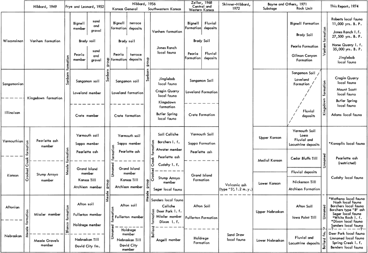
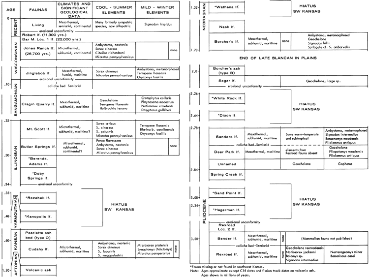
Intensive study of the area began in 1936 when C. W. Hibbard and a party from the University of Kansas went to Meade County to collect fossils. Beginning with the studies of Hibbard and later with the study by Frye (1942), Pleistocene deposits in southwestern Kansas have been assigned to the four glacial and four interglacial stages of the classic Pleistocene classification of central North America. Figure 2 shows the correlation of stratigraphic nomenclature in various reports on Meade County and the surrounding area. The attempt to fit the Pleistocene deposits and their contained faunas into the classical Pleistocene framework has led to differences in nomenclature and errors in correlation in the past.
Figure 2--Correlations and stratigraphic nomenclature for Southwestern Kansas. A larger version of this figure is available as an Acrobat PDF file (844 kB).
During much of the period of the development of the classification and correlation of the deposits and faunas in this area it was assumed that the Pearlette Ash bed represented a single event in geologic time. This ash was considered a key bed in the correlations that were developed. Since 1970, studies by Izett et al. (1970, 1971), Richmond (1970), Naeser et al. (1971), Boellstorff (1972). and this paper, have shown that there is a family of Pearlette-like ashes of different ages. In Meade County the ash underlying the Borchers fauna is dated at 2.0 m.y. and the ash overlying the Cudahy fauna is dated at 0.6 m.y. Other ashes with intermediate ages have been dated in the midwest (see Boellstorff, this guidebook). The discovery that the ash beds in southwestern Kansas were of different ages has made it necessary to recorrelate some of the deposits in the area and assign new ages to some of the contained faunas. The Borchers Fauna formerly considered to be of Yarmouthian age is now considered to be Aftonian or earlier (see Hibbard, 1973, Figure 2).
A climatic cycle within the Pleistocene consists of a glacial or cold period followed by an interglacial or warm period. Assuming the thermal maximum to occur at or near the end of the interglacial and a cycle to begin just following the thermal maximum, the cycle can be broken down into four phases in which the earliest or first phase is a period when the climate is somewhat cooler than the thermal maximum. Precipitation is somewhat higher and much more effective than in the thermal maximum. The fauna in the first phase is predominately warm but contains some cooler types. Near the end of the second phase temperatures are at their thermal minimum. Summer temperatures are much cooler but the winter temperatures may not be much cooler than at present. Precipitation may be about the same or higher than in the first phase. The fauna will be entirely a cool fauna. In the third phase the weather has begun to moderate. The fauna is predominately a cool type but toward the end of this phase warm elements may begin to appear. In the last phase, summers are warmer and winter temperatures seldom go below freezing. Precipitation is probably less and not as effective as in the preceding phase. The fauna is a warm type. During the latter part of this phase there is little deposition and widespread soils are formed.
In the northern part of the state, soil profiles with a caliche accumulation in the lower part of the profile are common. However, in southwestern Kansas, where conditions were probably more arid and leaching of the calcium carbonate less efficient, widespread massive caliche beds were formed during this period.
In the past, using the classical glacial sequence of central North America, each of the three earliest glacial stages were treated as a single event in which the climate gradually cooled to a minimum temperature then moderated to the thermal maximum. Treating the glacial stages as a single event has led to some difficulty in correlation of rock units and placement of some of the contained faunas.
Reed et al. (1966) and Bayne et al. (1971) have shown that there were periods of moderation within the glacial stages. Interstadial soil profiles occurring between two tills or between periglacial deposits within the glacial stages indicate moderation of the climate for a long enough period for development of a soil profile. In Nebraska and northeastern Kansas there is evidence of two stades within the Nebraskan Stage and three stades within the Kansan and Illinoisian stages.
Skinner and Hibbard, working in Brown County, Nebraska, were able to show that the so-called Aftonian local faunas of the plains region were older than the first continental glaciation and were older than the Dixon local fauna of Kingman County, Kansas (Hibbard, 1970 and Skinner et al., 1972). The local faunas, Spring Creek and Deer Park, in southwestern Kansas are assigned to the period prior to the first major continental glaciation. Taylor (1966) considered these faunas and others from this time interval in the plains region to have lived in the interval prior to the first major continental glaciation but later than an alpine or limited continental glaciation. The work of Skinner and Hibbard and that of Taylor does not conflict with the argument for stades or cycles within the glacial stages, and in fact, lends strength to it.
Although the fossil record in southwestern Kansas may seem unusually full, it is probable that no other area has been studied with the same methods and purposes. Virtually all the fossils collected in this region have been obtained by screen washing large quantities of matrix (Hibbard, 1949d). A few fossil localities represent channel accumulations of large bones and some artesian spring deposits contain only large bones, but most of the faunas come from deposits which have not been mechanically sorted to any great extent. Some localities rich in rodent remains seem to reflect the accumulation of small bones from the refuse of predatory birds, but, in the main, most fossiliferous sites represent the gradual accumulation of shells and bones in favorable habitats with no postmortem concentration.
Faunal differences may occur due to evolution of new forms and extinctions of old ones and to shifts in geographic range of faunal types brought about by changes in climate. The climatic changes are inferred from comparison of the components of the fauna with climatic requirements of living forms or, in the case of extinct forms, by their association with forms still living. In all probability the climatic requirements of some forms have changed. Some types may have become more restricted in their habitat and other types less restricted.
Climatic inferences can be made from the results of the study of the fossil record from the Meade County area. The reliability of these fossil inferences depends, in large part, upon the quality of the fossil sample. Diversity of fossil assemblages is therefore necessary for reasonable conclusions about ancient climates.
Fauna, both past and present, have influenced and adjusted to the world around them. They react to the environment around them in different ways. The interpretation of a fossil assemblage therefore requires a reconstruction of the local habitat. The fossil assemblages in Meade County indicate marked climatic changes during the Pleistocene that included both wetter and dryer periods than at present. The assemblages in Meade County include species which now live far to the south and other species which now live far to the north or at much higher elevations. These changes in assemblages indicate changes in temperature and moisture throughout the different intervals of the Pleistocene when these various assemblages lived. Figures 3 and 4 show the sequence of Pleistocene local faunas in Meade County along with the climatic cycles and the principal faunal components of the local faunas. In Figure 3 it is assumed that the cycle began at the termination of the thermal maximum, the formation of the soil caliche has ceased, temperatures began to cool slightly, and precipitation was somewhat higher and much more effective. Succeeding cycles followed the same pattern. There probably were similar climatic cycles in the late Pliocene. Each succeeding cycle being somewhat cooler until the minimum temperature during Kansan time was reached.
Figure 3--Faunal sequence and climatic cycles in Meade County.
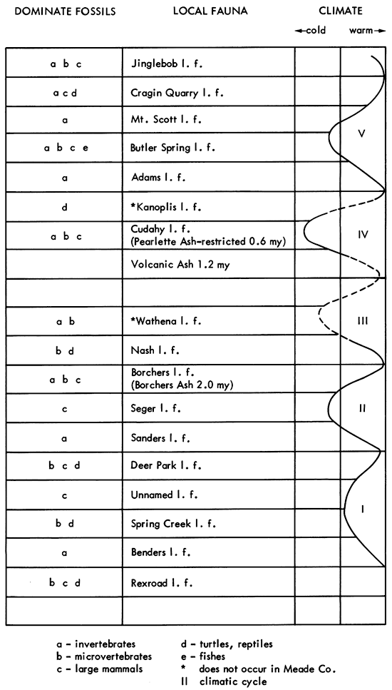
Figure 4--Pleistocene and Pliocene local faunas with climatic data. A larger version of this figure is available as an Acrobat PDF file (640 kB).
Down-dropped strata on the west side of the Crooked Creek fault have produced artesian water conditions over a large part of central Meade County. At the present time the largest natural artesian springs are south and southwest of Meade on the Big Springs Ranch and in Meade County State Park. The individual vents of these present springs are probably of no great age, but there have been similar springs in the area since the late Pliocene.
Five ancient artesian spring deposits have been exploited for fossils. Three of these are from the Rexroad Formation. The oldest is in Keefe Canyon (locality KU-22 of Hibbard and Riggs, 1949). Next oldest is KU-3 (Hibbard, 1970a), and the youngest is KU-2 (Hibbard, 1941). The Deer Park Quarry local fauna, KU-1 (Hibbard, 1956), occurs beneath a caliche in the first Pleistocene cycle. The last is the Cragin Quarry local fauna, locality KU-6 (Hibbard and Taylor, 1960, and U.S.G.S. Cenozoic locality 21, 274), in the Kingsdown Formation.
The artesian springs in Meade County have contributed to our knowledge of the paleontology and zoology in several ways. The springs have helped to preserve many fossils and have furnished favorable habitats for animals which otherwise could not have lived locally. Their continued existence illustrated the environment of the ancient spring deposits. The fauna from the five springs which have been exploited are warm faunas. The two Pleistocene faunas (Deer Park and Cragin Quarry) contain some cooler elements which in the case of Cragin Quarry are confined to aquatic invertebrates. It is probable that the climatic requirements of the vertebrates and land snails contained in these faunas more nearly represent the climate prevailing during these periods than the aquatic species. The more uniform temperature of the spring water would permit the continued existence of some of the more northern types of invertebrates.
The recent artesian springs provide habitats for at least three kinds of animals which otherwise would be unable to live in Meade County. These are as follows:
The springs are important to these animals in different ways. The fresh water snail, P. exacuous, has a wide distribution over most of northern North America. The Meade County occurrence is several hundred miles from the nearest known occurrence. It lives at only one place in this area, in the cool water of the artesian spring in pond number 1, Meade County State Fish Station. It is thought to be able to survive because the spring provides a habitat which does not become intolerably warm during the summer.
Similar reasoning applies to the lemming, a southern "island" population of a northern species. The summer cool habitat around the springs enable it to live on, while the present climate restricts its normal range to the north.
The water mite is interesting for it is an endemic species of an originally South American genus. Northward dispersal of this group probably took place during a warm interval of the Pliocene or Pleistocene and the mite has survived because the springs remained relatively warm during the cold intervals of the Pleistocene or the present winters.
Five genera of mammals present in the upper Rexroad local faunas (KU-2, 2a, and 3) are unknown from the younger Pleistocene deposits.
These genera of mammals are:
and three rabbits:
Forty-eight species of mammals are known from KU localities (Rexroad) 2, 2a, and 3. Twenty-one are confined to the Rexroad and older Pliocene faunas. These include five species of invertebrates, four species of amphibians, four species of reptiles, and eight species of birds which are confined to the Rexroad or older Pliocene faunas.
Ten different kinds of snakes have been reported from the Rexroad in locality 3. One of these is the copperhead, an eastern snake (Brattstorm, 1967).
The local faunas from the first climatic cycle above the massive Rexroad caliche are described from oldest to youngest in the following paragraphs; they are: Bender, Spring Creek, Unnamed, and Deer Park local faunas. The Bender, if local fauna, is principally a molluskan fauna and is included in this cycle because it occurs stratigraphically above the vertebrate faunas in the Rexroad and above the Rexroad caliche (fig. 3). Most species of mollusks in the Bender fauna also occur in the Rexroad fauna but some requiring more moist conditions and cooler conditions also are present. Miller (1964) studied additional mollusks from the Cottrell pasture locality (UM-K1-59) and concluded that the Bender local fauna was intermediate between the Rexroad fauna and the Sand Draw local fauna in northern Nebraska. The Bender local fauna, although placed in the earliest phase of the cycle above the Rexroad, should have strong affinities to the Rexroad fauna.
The Spring Creek local fauna is placed in the second phase of the first cycle. Abundant remains of the fresh water snail, Biomphalaria kansasensis Berry which is a subtropical to tropical group of snails indicates warm moist conditions during this phase. B. kansasensis probably became extinct in this area in the following cool phase of the cycle. It certainly was extinct by the time of the cool Cudahy fauna.
The Unnamed local fauna is known from only five large mammals. The mastodon Stegomastodon mirificus shows a species change from the upper Pliocene locality KU-3 local fauna. The large Geochelone (land tortoise) and Gopherus (land tortoise) occur in this fauna. The presence of these tortoises indicates a mild climate during this phase. However, it is believed that throughout this cycle temperatures were not appreciably lower than they had been earlier but that summers may have been cooler and precipitation may have been greater and more effective.
The Deer Park local fauna is a warm fauna that, at one time, was considered to be interglacial; however, it is now placed in the last phase of the first cycle. It occurs below a soil caliche which formed during the arid conditions existing at the close of this cycle.
Four species of mammals are confined to this time interval. Three genera of mammals Ogmodontomys, a vole; Trigonictis, a grison; and Buisnictis, a small skunk-like mustelid, make their last appearance. Twenty-six species of mammals are known from this cycle.
The second climatic cycle in Meade County includes three local faunas. These are, from oldest to youngest, the Sanders, Seger, and the Borchers local faunas. The Sanders, like the Benders, is placed in the earliest phase of a cycle. It is dominantly a warm fauna but contains some cooler types requiring more moist conditions than existed in the earlier Deer Park fauna. The Sanders occurs above a persistent soil caliche. The habitats from which the Sanders local fauna come include semipermanent shallow ponds or stream backwaters with surrounding grassy areas. Woodland, if present, was not well developed. The climate differed from that of the present in that the summers were cooler and precipitation was more effective. Winters were probably much warmer than at the present time.
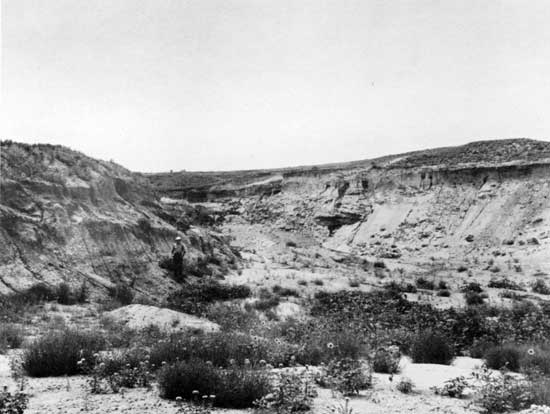
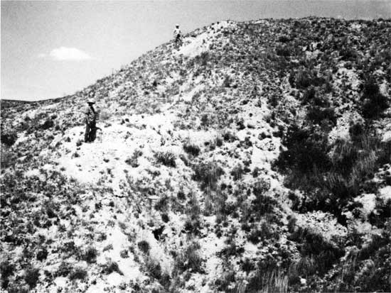
The Seger local fauna consists entirely of large mammals. This fauna is assigned to late Blancan age. Plesippus and Nannippus make their last appearance. The tortoise Geochelone is present indicating mild climatic conditions similar to conditions that existed during the earlier unnamed phase of the first cycle (Plate 2).
Plate 2--Seger gravel pit, NW SW SE sec. 33, T. 32 S., R. 29 W.
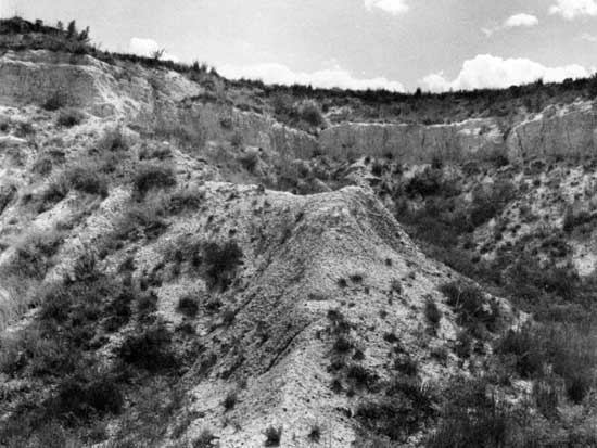
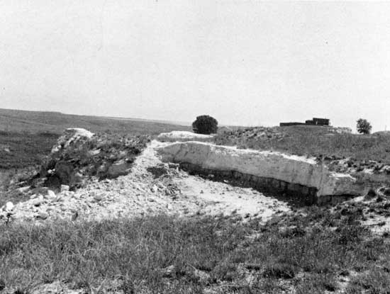
The Borchers local fauna occurs in silts just above the Borchers type B volcanic ash which has been dated at 2 m.y. (Plate 3). The Borchers is a warm fauna and includes a large land tortoise Geochelone, eleven species of snakes and twenty-five species of mammals. Nine species of mammals are known only from this fauna. Sorex taylori, previously known only from the Rexroad fauna (locality 3) reappears for the last time. Two genera, Hypolagus, a rabbit, and Etadonomys, a kangaroo-rat, make their last appearance.
Plate 3--Borchers ash and Borcher fauna locality, NW NE sec. 21, T. 33 S., R. 28 W.
The Borchers local fauna was originally considered to be of Yarmouthian age because of its occurrence above a volcanic ash; however, fission-track dating has shown that the age of the Borchers Ash is 2.0 m.y. The age of Pearlette Ash (restricted) which overlies the Cudahy fauna is 0.6 m.y.
The Nash local fauna occurs a few feet above the Borchers fauna. This fauna is a warm fauna containing many species with southern affinities but also contains Synaptomys Mictomys which now ranges northward from extreme northern United States. The fauna indicates moisture was more effective than it presently is in this area. Winters were no cooler than Phrynosoma cornutum, Texas horned toad, could tolerate but cool enough for S. Mictomys to live. The foregoing description would indicate that the Nash local fauna should belong in the earliest phase of the cycle succeeding the Borchers local fauna; however, the Nash local fauna underlies a caliche. If this caliche proves to be much younger than the Nash local fauna then the placement of the fauna in the earliest phase of the cycle following the Borchers is in order.
In Meade County a considerable time interval is missing from the fossil record between the Nash local fauna and the Cudahy local fauna. The Cudahy has long been considered to be late Kansan in age. Figure 4 indicates an approximate age for the Cudahy of slightly over 0.6 m.y., an age for the Nash of about 1.75 m.y., and a volcanic ash dated at 1.2 m.y. This ash is unlike the Pearlette type ash and may be Bishop type (Plate 4). The Wathena local fauna, about 1.32 m.y., is not present in Meade County but is in the glaciated region of northeast Kansas. The Wathena local fauna is a cool fauna which occurs below a well-developed soil profile below a glacial till of Kansan age and probably is late Nebraskan in age. The type "S" volcanic ash which locally overlies a reportedly warm fauna in Nebraska has been dated at 1.2 m.y. and may occur near the time line between the Kansan and Aftonian stages. Ash dated at 1.2 m.y. is present 22 feet above Borchers ash (2 m.y.) about 1/4 mile north of the type section of the Borchers in Meade County.
Plate 4--Borchers ash below and intermediate age ash (1.2 m.y.) in exposure 1/2 mile north of Borchers fauna locality, NW SE sec. 16, T. 33 S., R. 28 W.
Although there is evidence in Nebraska (Reed and Dreesen, 1965) and in northeastern Kansas (Bayne, 1969) of three cycles or stades in the Kansan glaciation, this evidence has not been found in the fossils recovered in Meade County. The Cudahy fauna considered to be of late Kansan age is the only Kansan fauna known to be present in Meade County. Why the fossil record of the Kansan glaciation is so poorly represented in Meade County while the record in the Nebraskan and Illinoisian stages are both well represented is unknown.
The Cudahy fauna is a cool type which occurs below the Pearlette (restricted) type "O" volcanic ash in Meade County (Plate 5) and in numerous localities in the plains region. Twenty-eight species of mammals are known from the Cudahy in Meade County and ten of the extinct species are known only from the Cudahy fauna. Four of these are shrews and the other six are rodents.
Plate 5--Cudahy fauna quarry at Cudahy mine, near cen. sec. 2, T. 31 S., R. 28 W.
The climate at the time of the Cudahy fauna was colder than any of the preceding cool phases of the climatic cycles. Probably from the late Pliocene to the late Kansan each succeeding cycle was somewhat cooler than the preceding cycle. Boreal elements in the Cudahy fauna indicate that summers were much cooler than those of today. The winters may not have been as severe as at present but the mean temperature was considerably cooler than at present or in preceding intervals.
A Yarmouthian fauna is not known from Meade County. For many years the Borchers fauna was assigned a Yarmouthian age; however, fission-track dating of the ash below the Borchers fauna indicated that the Borchers fauna was much older. It has been assigned an interstadial age within the Nebraskan Stage. The Kanopolis local fauna from Ellsworth County in central Kansas is a warm fauna and is believed to be of Yarmouthian age.
Several faunas present in Meade County are assigned an Illinoisan age. These are from oldest to youngest, the Adams, Butler Springs, Mt. Scott, and Cragin Quarry local faunas. Figure 3 indicates a single cycle within the Illinoisan in this area and only a single cycle has been recognized in Kansas. In Nebraska three cycles of deposition are recognized. The climate during the time of the Adams fauna was similar to that of the earlier Benders and Sanders faunas in that there was probably more moisture and the precipitation was much more effective than in the preceding Yarmouthian interglacial state. The Adams local fauna is assigned to the first phase of the cycle. The Butler Springs and the Mr. Scott local faunas are cooler than the preceding Adams and the succeeding Cragin Quarry local faunas and are assigned to phases 2 and 3 respectively. The Cragin Quarry fauna is a warm fauna recovered from sand tubes of a former artesian spring and is considered to represent the fourth phase of the cycle. Cool elements in the Cragin Quarry fauna, which are nearly all aquatic forms, can be attributed to the more nearly uniform temperatures of the artesian spring waters present when the faunal elements were living.
Deposits of Wisconsinan age which are present in Meade County have not been studied as extensively as older deposits in the area and therefore are not as well understood. The Jinglebob local fauna has been described as a late Sangamon interglacial fauna; however, in Figure 3 the Jinglebob is shown as being in the first phase of a Wisconsinan cycle. The fauna indicates somewhat cooler and more moist conditions existed than at the time of the preceding Cragin Quarry local fauna.
Other local faunas of the Wisconsinan stage which have been studied include the Horse Quarry local fauna which has been dated about 35,000 years B.P. (before present). The Jones local fauna dated 26,700 B.P. is probably pre-Farmdale. The Bar M. local fauna in Oklahoma, dated 21,360 B.P., is probably late Farmdale or post-Farmdale. The youngest fauna studied in this area is the Robert local fauna dated 11,000 B.P. This fauna is probably Two Creekian or Bradian age.
Throughout the preceding discussion emphasis has been placed on the cyclic pattern into which the faunal sequence has been placed. Placement of the local faunas within this framework has depended on a number of factors. Important among these factors are evolution and extinctions of the species and habitat requirements of the species. Placement of the faunas within the classic framework of the Pleistocene has been avoided as much as possible, especially in the early and medial Pleistocene. In fact, there is no clear agreement as to where the Pliocene-Pleistocene boundary should be placed. Placement of this boundary at the beginning of the first evidence of climatic cooling is hardly valid since there is growing evidence of climatic cycles consisting of warm and cool phases at least as early as late Pliocene time. From late Pliocene to late Kansan time each succeeding cycle was cooler than the preceding cycle until minimum temperature were attained in the late Kansan. During the cool phases of the earlier cycles some of the warm faunal elements were able to survive.
The use of stratigraphic names for those deposits which occur between the 0.6 m.y. ash and the 2.0 m.y. ash has been avoided. Additional stratigraphic studies are needed before new names are proposed.
Adams, G.I., 1902, Note on a Tertiary terrane new in Kansas geology: Amer. Geologist, v. 29, p. 301-303.
Bayne, C.K., 1968, Evidence of multiple stades in the lower Pleistocene of northeastern Kansas: Tran. Kans. Acad. of Sci., v. 71, No. 3, p. 340-349.
Boellstorff, J.D., 1972, Fission-track ages of shards from some mid-continent Pleistocene volcanic ash deposits: Geol. Soc. Amer., abstracts with programs" v. 4, no. 4, p. 274. In letter, March 6, 1973, Boellstorff gave the Borchers volcanic ash (type B) as 1.97 + 0.25 m.y. and stated, "that all dates in the above publication are approximately 20% too old."
Boellstorff, J.D., 1972 or 1973 if published in time replaces the above. New Zealand Abstract.
Brattstrom, B.H., 1967, A succession of Pliocene and Pleistocene snake faunas from the High Plains of the United States: Copeia, 1967, no. 1, pp. 188-202. This study is based on over 11,000 skeletal elements.
Cragin, F.W., 1896, Preliminary notice of three late Neocene terranes of Kansas: Colorado Coll. Studies, v. 6, p. 53-54.
Darton, N.H., 1899, Preliminary report on the geology and water resources of Nebraska west of the One Hundred and Third Meridian: U.S. Geol. Survey, 19th Ann. Rept., pt. 4, Hydrology, p. 719-785.
Darton, N.H., 1920, U.S. Geological Survey Atlas, Syracuse-Lakin folio, (no. 212), 10 p.
Elias, M.K., 1931, The geology of Wallace County, Kansas: Kans. Geol. Survey, Bull. 18, 254 p. [available online]
Frye, J.C., 1942, Geology and ground-water resources of Meade County, Kansas: Kansas Geol. Survey, Bull. 45, p. 1-152. [available online]
Frye, J.C., and Hibbard, C.W., 1941, Pliocene and Pleistocene stratigraphy and paleontology of the Meade Basin, southwestern Kansas: Kansas Geol. Survey, Bull. 38, Pt. 13, p. 389-424. [available online]
Frye, J.C., and Schoff, S.L., 1942, Deep-seated solution in the Meade Basin and vicinity, Kansas and Oklahoma: Amer. Geophysical Union, Trans., p. 35-39.
Haworth, E., 1896, Local deformation of strata in Meade County, Kansas, and adjoining territory (preliminary): Amer. Jour. Sci., v. 152, p. 368-373.
Hay, O.P., 1917, On a collection of fossil vertebrates made by Dr. F.W. Cragin in the Equus beds of Kansas: Kansas Univ. Sci. Bull., v. 10, no. 4, p. 39-51.
Hay, R., 1890, A geological reconnaissance in southwestern Kansas. U.S. Geol. Survey, Bull., 57, p. 1-49.
Hibbard, C.W., 1941, Paleoecology and correlation of the Rexroad fauna from the Upper Pliocene of southwestern Kansas, as indicated by the mammals. Univ. Kansas, Sci. Bull., v. 27, no. 6, p. 79-104.
Hibbard, C.W., 1944, Stratigraphy and vertebrate paleontology of Pleistocene deposits of southwestern Kansas: Geol. Soc. Amer., Bull., v. 55, p. 707-754.
Hibbard, C.W., 1949, Pleistocene stratigraphy and paleontology of Meade County, Kansas: Univ. Mich. Contrib. Mus. Paleontol., v. 7, no. 4, p. 63-90.
Hibbard, C.W., 1949d, Techniques of collecting microvertebrate fossils: Contrib. Mus. Paleo.: Univ. of Michigan, vol. 8, no. 2, p. 7-19.
Hibbard, C.W., 1956, Vertebrate fossils from the Meade Formation of southwestern Kansas: Mich. Acad. Sci., Arts and Let., Papers, v. 41, p. 145-203.
Hibbard, C.W., 1960, An interpretation of Pliocene and Pleistocene climates in North America. Mich. Acad. Sci., 62nd Ann. Rept., p. 5-30.
Hibbard, C.W., 1970a, A new microtine rodent from the Upper Pliocene of Kansas: Univ. Mich. Contrib. Mus. Paleontol., v. 23, no. 7. p. 99-103.
Hibbard, C.W., 1970b, Pleistocene mammalian local faunas from the Great Plains and Central Lowland Provinces of the United States; in, Pleistocene and Recent environments of the Central Great Plains, W. Dort, Jr., and J.K. Jones, Jr., (ed.): Univ. Kansas, Dept. Geol. Sp. Publ. 3, Univ. Kans. Press, p. 395-433.
Hibbard, C.W., and Riggs, E.S., 1944, Upper Pliocene vertebrates from Keefe Canyon, Meade County, Kansas: Geol. Soc. Amer., Bull., v. 60, p. 829-860.
Hibbard, C.W., and Taylor, D.W., 1960, Two late Pleistocene faunas from southwestern Kansas. Univ. Mich. Contrib. Mus. Paleontol., v. 16, no. 1, p. 1-223.
Izett, G.A., Wilcox, R.E., and Borchardt, G.A., 1972, Correlation of a volcanic ash bed in Pleistocene deposits near Mount Blanco, Texas, with the Guaje Pumice bed of the Jemez Mountains, New Mexico: Quaternary Research, v. 2. no. 4, p. 554-578.
Izett, G.A., Wilcox, R.E., Powers, H.A., and Desborough, G.A., 1970, The Bishop ash bed,, a Pleistocene marker bed in the Western United States: Quaternary Research, v. 1, no. 1,, p. 121-132.
Izett, G.A., Wilcox, R.E., Obradovich, J.D., and Reynolds, R.L., 1971, Evidence for two Pearlette-like ash beds in Nebraska and adjoining areas: Geol. Soc. Amer., abstracts with programs, v. 3, no. 4, p. 265-266.
Landes, K.K., 1928, Volcanic ash resources of Kansas: Kansas State Geol. Survey, Bull., 14, p. 1-58. [available online]
Leonard, A.B., 1946, Three new pupillids from the lower Pleistocene of central and southwestern Kansas: Nautilus, v. 60, p. 20-24.
Miller, Barry B., 1964, Additional mollusks from the late Pliocene Bender local fauna, Meade County, Kansas: Jour. of Paleo., vol. 38, no. 1, p. 113-117.
Mitchell, R., and Mitchell, A.V., 1958, Studies of a new water-mite, Tyrrellia hibbardi, from Kansas springs: Amer. Microscopical Soc., Trans., v. 77,, no. 1, p. 11-18.
Naeser, C.W., Izett, G.A., and Wilcox, R.E., 1971, Zircon fission-track ages of Pearlette-like volcanic ash beds in the Great Plains: Geol. Soc. Amer., abstracts with programs, v. 3. no. 7. p. 657.
Parker, H.N., 1911, Quality of water supplies of Kansas: U.S. Geol. Survey, Water-supply Paper, 273, p. 1-375. [available online]
Reed, E.C., and Dreeszen, V.H., 1965, Revision of the classification of the Pleistocene deposits of Nebraska: Neb. Geol. Survey, Bull. 23, p. 1-63.
Richmond, G.M., 1970, Comparison of the Quaternary Stratigraphy of the Alps and Rocky Mountains: Quaternary Research, v. 1. no. 1. p. 3-28.
St. John, O., 1887, Notes on the geology of southwestern Kansas: Kansas State Board Agric. Rept., v. 10, pt. 2, p. 132-152.
Skinner, M.F., et al., 1972, Early Pleistocene preglacial and glacial rocks and faunas of North-Central Nebraska. Amer. Mus. Nat. Hist. Bull., v. 148, art. 1, p. 1-148.
Smith, H.T.U., 1938, Preliminary notes on Pleistocene gravels in southwestern Kansas: Kansas Acad. Sci., Trans., v. 40, p. 283-291.
Smith, H.T.U., 1940, Geologic studies in southwestern Kansas. Kansas Geol. Survey, Bull. 34, p. 1-212. [available online]
Taylor, D.W., 1960, Late Cenozoic Molluscan faunas from the High Plains: U.S. Geol. Survey, Prof. Pap. 337, p. i-iv + 94 p. [available online]
Taylor, D.W., 1966, Summary of North American Blancan non-marine mollusks: Malacologia, v. 4, no. 1, p. 1-172.
Next Page--Road Log and Stratigraphic Sections
Kansas Geological Survey, Guidebook 24th Annual Meeting Midwestern Friends of the Pleistocene
Placed on web Nov. 9, 2010; originally published in 1976.
Comments to webadmin@kgs.ku.edu
The URL for this page is http://www.kgs.ku.edu/Publications/Bulletins/GB1/index.html