Kansas Geological Survey, Environmental Geology Series 2, originally published in 1978
Research supported by Contracts AT-49-24-0286 and NRC-04-77-017 U.S. Nuclear Regulatory Commission
Originally published in 1978 as Kansas Geological Survey Environmental Geology Series 2. This is, in general, the original text as published. The information has not been updated. An Acrobat PDF version (5 MB) is also available.
Executive Summary
Introduction
Purpose and Methods of Research
List of Kansas Earthquakes
Acknowledgments
References
Twenty-five earthquakes whose epicenters were within the borders of Kansas have been reported during about the past 110 years.
Two large nuclear and coal-fired electrical generating complexes and several existing or proposed reservoirs are sited near or in areas of past seismic activity in Kansas. The seismic design parameters for these facilities are based largely upon the locations, sizes, and frequency of earthquakes which have occurred in the region as far back as reports are available. Because of the critical nature of this information in estimation of seismic risk, it is important that the date, location, and size of each earthquake be determined as accurately as possible.
The original purpose of this study was to verify the basis for placement of the 1867 and 1906 earthquake epicenters near Manhattan, Kansas. It was subsequently expanded to review the reports of all earthquakes whose epicenters were within the boundaries of Kansas. The investigation included a review of the references cited for Kansas earthquakes by authors of previously pUblished state, regional, and national earthquake listings. In addition, old newspaper files, microfilms, and other records at the University of Kansas and the Kansas State Historical Society were searched for reports which may have been previously overlooked or not recorded.
As a result of this study three changes in epicenter locations were made, including those of the two largest earthquakes:
| Date | MM Intensity | Location | |
|---|---|---|---|
| From | To | ||
| April 24, 1867 | VII-VIII | 22 mi. NW Manhattan | Wamego vicinity |
| Nov. 8, 1875 | V | Valley Falls | Topeka vicinity |
| Jan. 7, 1906 | VII | 10 mi. N Manhattan | Manhattan vicinity |
Changes in Modified Mercalli intensities for five earthquakes were made:
| Date | MM Intensity | Location | |
|---|---|---|---|
| From | To | ||
| Mar. 18, 1927 | V | VI | White Cloud |
| Nov. 26, 1929 | IV | V | Ashland |
| Aug. 9, 1931 | IV-V | VI | Turner |
| Jan. 28, 1932 | III, V | VI | Ellis |
| Nov. 10, 1942 | III, IV | V | Hays |
This report includes a complete list of all felt reports compiled during this study.
The proposed construction of several large nuclear or coal-fired electrical generating complexes, dams, and other critical facilities in or near areas associated with past seismic activity in Kansas has raised questions concerning future earthquake probability and risk.
The location, size, and frequency of past earthquakes are presently used in calculating the seismic design parameters for such facilities. An additional safety factor is usually applied because the design life of a major dam and reservoir, for example, is approximately twice the 110-year period of record for reported earthquakes in Kansas. Because of the critical nature of such listings, it is important that the catalog be as complete and correct as possible.
Merriam (45) published a brief catalog of historical earthquakes in Kansas which has been the standard reference to the present time. Merriam's earthquake reports were cited by Docekal (17) in a regional catalog and by Coffman and von Hake (8) in a recent update of a national catalog of seismic events.
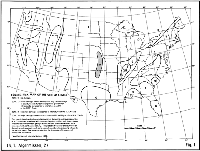
Algermissen (2) utilized published data on historical earthquakes to compile a Seismic Risk Map for the conterminous United States (Figure 1). This map has been included in the U.S. Uniform Building Code for determining criteria for earthquake-resistant design of critical structures. A seismic risk "2" zone which lies across the central and eastern parts of Oklahoma, Kansas, and Nebraska was delineated by Algermissen from the overlapping felt areas of several Modified Mercalli VII-VIII earthquakes which have occurred in the past near El Reno, Oklahoma; Manhattan, Kansas; and southeastern Nebraska. These earthquakes were believed to be related to movement on faults associated with a buried rib of Precambrian granite rocks which comes to within about 600 feet (183 meters) of the surface in Nemaha County, Kansas, and is for that reason called the "Nemaha granite ridge." The Nemaha ridge is known to be bounded along its eastern edge by a system of faults which is named the Humboldt Fault Zone because it was first reported near Humboldt, Nebraska (11).
Figure 1--Seismic risk map of the United States
The State Geological Surveys of Oklahoma, Kansas, and Nebraska are presently making a five-year detailed study of the sources of seismicity in the Nemaha Uplift area for the Site Safety Research Branch, Division of Reactor Safety Research, U.S. Nuclear Regulatory Commission.
This report comprises a part of that research.
The two largest earthquakes reported to date in Kansas are the 1867 and 1906 MM VII-VIII earthquakes. Merriam (45, p. 87) placed the epicenter of the 1867 event "... about 22 miles northwest of Manhattan in northeastern Riley County." He located the 1906 epicenter "... about 10 miles north of Manhattan in western Pottawatomie County." The precise locations of these two events are important in determining which of several known or inferred buried faults may have been responsible for the earthquakes. The original intent of the library research conducted by DuBois was to review the primary sources of Merriam's references for all earthquakes but especially to determine the basis for his locations of the 1867 and 1906 epicenters. This was later expanded to include, where available, other sources cited by Docekal (17) and Coffman and von Hake (8). At the same time it was decided to search for additional local felt reports of all earthquakes within the boundaries of Kansas.
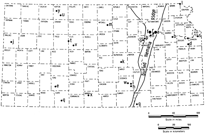
The study included a detailed search of old newspaper files and other reports at Spencer Research Library and Watson Library at the University of Kansas in Lawrence; and of the extensive old newspaper files and microfilms at the Kansas State Historical Society in Topeka. This involved compiling a list of newspapers which were in operation within a certain radius of each particular event during the period that the earthquake effects were likely to have been reported (usually from the actual date to about two weeks afterward in order to find any reports sent later to weekly papers by rural correspondents). Contemporary maps of the period were utilized to locate felt reports from rural localities or small towns which have since changed names or gone out of existence. The earthquake epicenters located through this research are shown in Figure 2.
Figure 2--Earthquakes in Kansas. Location and dates of earthquakes in Kansas during the past 110 years. The number following the date is the earthquake intensity on the Modified Mercalli Scale.
| Explanation | ||||
|---|---|---|---|---|
| a 1867 VIII | f 1906 VII | k 1927 V | p 1929 V | u 1933 V |
| b 1875 V | g 1907 IV | l 1927 VI | q 1929 V | v 1942 IV |
| c 1881 III | h 1919 IV | m 1928 IV | r 1929 V | w 1948 IV |
| d 1903 II | i 1919 IV | n 1929 V | s 1931 VI | x 1956 VI |
| e 1904 IV | j 1926 ? | o 1929 V | t 1932 VI | y 1961 V |
The Modified Mercalli Intensity scale of 1931 (Table 1) was used to assign maximum MM Intensity to each individual felt report. These were, in turn, plotted on a map and, where possible, contoured to produce an isoseismal map for the particular earthquake.
Table 1--Modified Mercalli Intensity Scale of 1931 (Abridged and rewritten) (From Richter, C. F., (1958), Elementary Seismology (W. H. Freeman & Co., Inc.), pp. 136 - 138).
| Masonry A, B, C, D. To avoid ambiguity of language, the quality of masonry, brick or otherwise, is specified by the following lettering (which has no connection with the conventional Class A, B, C construction). | |
| Masonry A. Good workmanship, mortar, and design; reinforced, especially laterally, and bound together by using steel, concrete, etc.; designed to resist lateral forces. | |
| Masonry B. Good workmanship and mortar; reinforced, but not designed in detail to resist lateral forces. | |
| Masonry C. Ordinary workmanship and mortar; no extreme weaknesses like failing to tie in at corners, but neither reinforced nor designed against horizontal forces. | |
| Masonry D. Weak materals, such as adobe; poor mortar; low standards of workmanship; weak horizontally. | |
| I. | Not felt. Marginal and long-period effects of large earthquakes (for details see text). |
| II. | Felt by persons at rest, on upper floors, or favorably placed. |
| III. | Felt indoors. Hanging objects swing. Vibration like passing of light trucks. Duration estimated. May not be recognized as an earthquake. |
| IV. | Hanging objects swing. Vibration like passing of heavy trucks; or sensation of a jolt like a heavy ball striking the walls. Standing motor cars rock. Windows, dishes, doors rattle. Glasses clink. Corckery clashes. In the upper range of IV wooden walls and frame creak. |
| V. | Felt outdoors; direction estimated. Sleepers wakened. Liquids disturbed, some spilled. Small unstable objects displaced or upset. Doors swing, close, open. Shutters, pictures move. Pendulum clocks stop, start, change rate. |
| VI. | Felt by all. Many frightened and run outdoors. Persons walk unsteadily. Windows, dishes, glassware broken. Knickknacks, books, etc., off shelves. Pictures off walls. Furniture moved or overturned. Weak plaster and masonry D cracked. Small bells ring (church, school). Trees, bushes shaken (visibly, or heard to rustle -- CFR). |
| VII. | Difficult to stand. Noticed by drivers of motor cars. Hanging objects quiver. Furniture broken. Damage to masonry D, including cracks. Weak chimneys broken at roof line. Fall of plaster, loose bricks, tones, tiles, cornices (also unbraced parapets and architectural ornaments -- CFR). Some cracks in masonry C. Waves on ponds; water turbid with mud. Small slides and caving in along sand or gravel banks. Large bells ring. Concrete irrigation ditches damaged. |
| VIII. | Steering of motor cars affected. Damage to masonry C; partial collapse. Some damage to masonry B; none to masonry A. Fall of stucco and some masonry walls. Twisting, fall of chimneys, factory stacks, monuments, towers, elevated tanks. Frame houses moved on foundations if not bolted down; loose panel walls thrown out. Decayed piling broken off. Branches broken from trees. Changes in flow or temperature of springs and wells. Cracks in wet ground and on steep slopes. |
| IX. | General panic. Masonry D destroyed; masonry C heavily damaged, sometimes with complete collapse; masonry B seriously damaged (General damage to foundations -- CFR.) Frame structures, if not bolted, shifted off foundations. Frames racked. Serious damage to reservoirs. Underground pipes broken. Conspicuous cracks in ground. In alluviated areas sand and mud ejected, earthquake fountains, sand craters. |
| X. | Most masonry and frame structures destroyed with their foundations. Some well-built wooden structures and bridges destroyed. Serious damage to dams, dikes, embankments. Large landslides. Water thrown on banks of canals, rivers, lakes, etc. Sand and mud shifted horizontally on beaches and flat land. Rails bent slightly. |
| XI. | Rails bent greatly. Underground pipelines completely out of service. |
| XII. | Damage nearly total. Large rock masses displaced. Lines of sight and level distorted. Objects thrown into the air. |
For the 1867 Manhattan earthquake, the "ten years ago today" column of the Topeka Commonwealth for April 24, 1877 contained a report of earthquake fountains or liquifaction "on the John Cotton Farm three miles south of Wamego." This is a criterion for MM Intensity VIII. Ms. Ruth Say, the Wabaunsee County Register of Deeds, was kind enough to search for and find a 1902 map showing the location of the Cotton Farm which was purchased in 1865. Recent airphotos indicate that the probable location of the area of liquifaction was on the floodplain of the Kansas River closely adjacent to the subsurface trace of the Humboldt Fault. It was largely on the basis of this report and an account of horses falling down during the earthquake at Louisville, a few miles north of Wamego and also near the trace of the Humboldt Fault that the epicenter was relocated to the general Wamego-Louisville-Manhattan area with the possible epicenter in the area of liquifaction mentioned above. Merriam (personal communication, July 16, 1976) stated that his placement of the 1867 and 1906 epicenters was "... based on whatever references are given in the published paper." A complete review of all the original sources of Merriam's references for the 1867 and 1906 earthquakes failed to find any felt reports which would justify placement of the epicenter locations 22 miles northwest and 10 miles north of Manhattan respectively. Therefore, the 1906 earthquake epicenter was also relocated by us to the general Manhattan area.
On the assumption that the Commandant's or Officer-of-the-Day's reports of Fort Riley and Fort Leavenworth might contain accounts of the effects of the 1867 or 1906 earthquakes, written inquiries were made to the Commanding Officers of those military facilities. Subsequent inquiries were made at their suggestion to the Old Army and Navy Records Branch of the National Archives in Washington, D.C., without result. DuBois later contacted the Federal Archives and Records Center in Kansas City, Missouri, also without finding the military records. Sources there, however, suggested that the monthly meteorological reports of weather stations might contain such records although their reports for Fort Riley and Leavenworth were not complete for the pertinent dates. Similar inquiries to the Civil Archives Division of GSA and the Smithsonian Institute Archives in Washington, D.C., also failed to reveal any new reports.
The Jesuit Order maintained a mission to the Pottawatomi Indians near St. Marys, Kansas, in 1867. Old journals or records containing accounts of the 1867 earthquake may be present at the Jesuit St. Louis University in St. Louis, Missouri. Some records may also still be extant in files of the Bureau of Indian Affairs from the U.S. Government Indian Agent to the Pottawatomi Tribe. We intend to investigate these possibilities.
The following earthquakes of historical record are listed in chronological order. Local reports for each event are arranged alphabetically and numbered accordingly. Reports not previously cited by others in standard catalogs are starred (*). Where sufficient felt reports were available, an isoseismal map is included. Arabic numbers on the map correspond to the numerical listing of the felt reports. Roman numerals along the isoseismal lines indicate their Modified Mercalli Intensity value.
[Note: Numbers in parentheses refer to the References at the end of this report.]
(See Figure 3, for location of the reports listed below)
| Lat: 39° 10' Long: 96° 18' | Near: Wamego (see Fig. 2, a) |
| Time: 2:30 p.m. | Felt Area: 300,000 sq. mi. (777,000 sq. km.) (8, 17, 45) |
Where reports are available, the following information has been included:
| Locality | Assigned MM Intensity |
Earthquake Effects |
|---|---|---|
| 1. Atchison, KS (Atchison Co.) (b) 2 shocks (c) S → N |
VI | Every building rocked to-and-fro Lamps thrown from tables & mantles Bottles from drug store thrown down People fled from buildings to streets Water in White Clay Creek moved rapidly after a standstill for several days No damage reported to buildings (5) Vibration passed westward or northward Wave moved from south to north First oscillation followed by heavier more perceptibly felt swell (12, 13) |
| 2. Chillicothe, MO (Livingston Co.) (a) 3:30 p.m. (b) one shock |
VI | Severe enough to cause plaster to fall from ceilings of several houses (49) |
| 3. Des Moines, IA (Polk Co.) |
VI | Rocked persons sitting in chairs Shook buildings (49) |
| 4. Dubuque, IA (Dubuque, Co.) (b) 3 shocks |
VI | Three shocks felt Openings formed in brick walls Furniture displaced Persons in chairs undulated backwards & forwards Windows rattled, pictures shook, chandelier swayed Not felt severely by ground floor--much felt by occupants of 2nd and 3rd stories (49) Panic - people fled to the streets Plastering came down in courthouse & other buildings (8, 49, 50) Gas burners vibrated like pendulums Cases shook in newspaper room (50) |
| 5. Emporia, KS (Lyon Co.) (a) 2:30 p.m. (b) more than one |
V - VI | Low rumbling sound followed by vibrations Houses shook, windows rattled Panic--people fled from buildings Brick & stone houses more severely affected than frame houses Small boxes fell off shelves (49) |
| 6. Fort Scott, KS (Bourbon Co.) |
II - III | Slight trembling in buildings, not alarming (49) |
| 7. Holton, KS (Jackson Co.) (a) 2:00 p.m. |
VI | Goods & wares fell off shelves Shook buildings People fled to the streets (49) |
| 8. Iola, KS (Allen Co.) (a) 2:45 p.m. |
VI | Shook houses Rattled crockery (49) |
| 9. Irving, KS (Marshall Co.) (a) 2:30 p.m. (b) lasted 30 sec. |
VI | Rumbling sound heard before shock Houses shaken severely Inmates rushed out of doors Lasted 30 seconds (49) |
| 10. Junction City, KS (Geary Co.) (a) 2:30 p.m. |
VI | Very heavy shock Rocked buildings to-and-fro, moving several inches (31, 49) Destroyed well being dug in town (17, 31, 49) Shock seems not to have extended over a quarter of a mile in width (31) |
| 11. Kansas City, KS (Wyandotte Co.) |
VI | Books unshelved Tables moved Pendant articles swung (bridles & harness) Two clock doors suddenly opened Crack in wall open & shut Water in tumblers spilled Plastering shaken off in one or two houses General panic--people fled to streets Every movable article of furniture & crockery rattled & shook about (49) |
| 12. Lawrence, KS (Douglas Co.) (a) 2:57 p.m. or 2:45 p.m. (b) 2 or 3 shocks |
VI | Three shocks felt over a period of 30 seconds (17) Earth trembled & vibrated Doors & windows violently shaken (8, 43) Type thrown down in printer's office Butcher's spring balance drawn down 1 1/2 lbs. (5, 33) Bottles shaken off druggist's shelves (8, 17, 43) Plaster broken off Loud rumbling noise (6, 17, 43, 49) Three-four loose stones knocked off Unitarian Church (17, 49) Rattled crockery, glassware, shook bundles from shelves (8, 49) Building with stone walls 30-inches thick shook very perceptibly People fled to streets One stove overturned in a house Books fell off shelves (49) |
| 13. Leavenworth, KS (Leavenworth Co.) (a) 2:30 p.m. (b) 3 shocks felt, 30 sec. duration (c) W → E |
VII | Plaster cracked entire length of ceiling--large portion fell to floor Man shaken off load of hay Two contiguous buildings lifted up, separated two inches, settled back Dishes, tumblers knocked off shelves Visible agitation of water in river Clocks stopped at 2:30 p.m. Nearly everything toppled over in private homes Plaster fell in brick law office, several other buildings Six-foot saws leaning against wall moved out six inches Rumbling like thunder (49) Stove pipe forced apart, some joints overlapping four inches Several chimneys overthrown Tables danced, dishes thrown to floor Piles of sheeting toppled down from counters in post office Plaster badly cracked in Billiard Hall (40, 49) Woman received electrical shock from spring water, smoke seen to come from bank (34) Shocks moved from west to east (41) |
| 14. Lecompton, KS (Douglas Co.) (a) 2:30 p.m. (b) one shock (c) came from SE or NW (2 conflicting reports) |
V - VI | Panic--people fled to streets Lane University building quivered Windows & doors danced (49) |
| 15. Lexington & Sedalia, MO (Lafayette & Pettis cos.) |
VI | Felt with equal force at Kansas City, Lexington, Sedalia, St. Joseph (49) |
| 16. Louisville, KS (Pottawatomie Co.) |
VII | Horses fell down in streets Chimneys toppled & fell (49) |
| 17. Manhattan, KS (Riley Co.) (a) 2:32 p.m. (c) S → N or SW → NE |
VII | Two-foot wave observed to move south to north on Kansas River (8, 17, 34, 45, 49) Clocks stopped No wave observed on Blue River Stacked photographs pitched over to SW Cattle alarmed Oscillation of houses seemed to approach the "overtopping point" (49) Inhabitants severely frightened Some people felt electric shocks (34, 49) Stone buildings with weak walls fractured but did not fall (8, 17, 34, 49) Aftershock occurred between 3-4 a.m. Thurs. (one day later) (34) |
| 18. Marysville, KS (Marshall Co.) (a) 2:30 p.m. (b) 1 - 3 minutes |
VI | Temporary alarm on part of a few Felt by people on first and second floors Fisherman on Spring Creek felt tree shake, saw all the others trembling Stone high school much shaken--along with desks, stove-pipes, & other furniture (72) Rumbling sound--like heavy trunks being dragged across planks Windows, doors, shutters , stove-pipes, all loose or hanging articles rattled, waved, swung back & forth fearfully (8, 72) Bottles & packages rattled, some shaken off shelves & broken (17, 72) |
| 19. Montgomery Co., KS | V | Shook buildings Knocked dishes off shelves People in moving vehicles did not feel it (witness was Topeka Weather Bureau man in 1906) (54) |
| 20. Mound City, KS (Linn Co.) (a) 3:00 p.m. (b) 15 seconds |
V | Houses violently shaken Doors opened Water shaken from buckets Loose articles tumbled around (49) |
| 21. Olathe, KS (Johnson Co.) |
V | Houses seen to totter, wave back & forth Shingles on roofs broke loose, fell to ground Glassware rattled Deep rumbling sound (49) |
| 22. Oskaloosa, KS (Jefferson Co.) (a) 2:34 p.m. (b) 15 - 20 sec. |
VI | Houses vibrated Movable items shaken & jostled Public panic--people fled to streets Rumbling noise Cupola of new school house reeled like drunken man (49) |
| 23. Ottawa, KS (Franklin Co.) |
V - VI | Houses emptied of occupants Buildings shaken (49) |
| 24. Paola, KS (Miami Co.) (a) 3:20 p.m. (b) 50 sec. (c) W → SE motion |
VII | Plaster fell from ceiling of large schoolhouse Buildings rocked Large brick building which housed the Republican newspaper office much injured--one side knocked down & destroyed West to southeast motion Those in eastern part of town nearly thrown down if standing Sound--rolling of large train over railroad (49) |
| 25. St. Joseph, MO (Buchanan Co.) (a) 2:35 p.m. (b) 20 sec. (c) E → W & W → E |
VII | Rumbling noise Shaking of entire surface of terra firma Drove everyone into streets Four-story brick buildings shaken from cornice to foundation stone Windows broken, plastering thrown down Ladies fainted, men turned pale Solid brick blocks swayed to & fro like reeds (49) Buildings shook, walls cracked, rocked, jarred (17,49) Brick walls of new school house, standing on elevated piece of ground where street had been cut down, cracked several feet from ground & bank on which it stood was also rent in a distinct seam (13) |
| 26. St. Louis, MO (St. Louis Co.) (a) 3:00 p.m. |
II - III | Shock felt here about 3:00 p.m. (49) |
| 27. Salina, KS (Saline Co.) (a) 2:30 p.m. (b) 10 sec. |
III (?) | Shaking lasted 10 seconds, no damage reported (49) |
| 28. Solomon, KS (Saline Co.) (a) 2:25 p.m. |
VII | Train on Pacific RR violently rocked by shock, locomotive was stopped and trainmen abandoned cab for fear the boiler was about to blow up (16, 31, 45, 49) |
| 29. Topeka, KS (Shawnee Co.) (a) 2:45 p.m. (b) 2 shocks (c) SW → NE |
VI | Waves in ceiling of Lincoln College observed to run southwest to northeast (49) People fled to streets Stone church rocked (49,53,56) Ceiling of Methodist Church bent up and down like waves on a pond Floor heaved & sank lower than its normal level Horses broke loose from hitching racks & ran toward open country (53, 56) All but one glass window broken in schoolhouse "below this city" (10, 17) |
| 30. Wamego, KS (Pottawatomie Co.) (a) about 2:45 p.m. |
VI - VII | Shaking & rocking of every house General alarm--people fled from buildings Plaster broken in houses Glasses shaken from lamps (49) |
| VIII (?) | Special Report from 3 mi. S. in Wabaunsee Co.--"on the farm of John Cotton, ... during the earthquake the earth opened and water was thrown out of the opening in considerable quantities. At another place not far distant from the above, the earth opened and fire & smoke issued out. So one of our papers states". (10) Walls cracked (17) |
|
| 31. Wapello, IA (Louisa Co.) |
IV | Motion of tremor described as "not violent, but easy swinging, giving one a sensation something like the first effects of a dram of wiskey". (50) |
| 32. Warrensburg, MO (Johnson Co.) (a) 2:50 p.m. (b) 10 sec. (c) SW → NE |
VI | Walls of church heaved "as if moved by a shock from SW" Glassware shook about Plastering fell from ceiling Buildings moved No damage (?) (49) |
| 33. Wathena, KS (Doniphan Co.) (a) 3:05 p.m. (b) 10 Sec. |
III (?) | Small earthquake visited this section at 3:05 p.m.--lasted 10 sec. (49) |
| 34. White Cloud, KS (Doniphan Co.) (b) 2 shocks |
V (?) | Two distinct severe shocks felt (49) |
| 35. Wyandotte, KS (Wyandotte, Co.) (a) 2:00 p.m. or 2:45 p.m. (c) N → S motion |
VI | Doors jarred open Windows rattled & jarred People fled to streets Houses swayed Dishes shook People awakened from naps (49) |
Carthage, Ohio Three mi. S. of Carthage on Miami Canal, an acre of ground sank 10', leaving a perpendicular wall of 10' on all sides (8, 17, 45, 49)
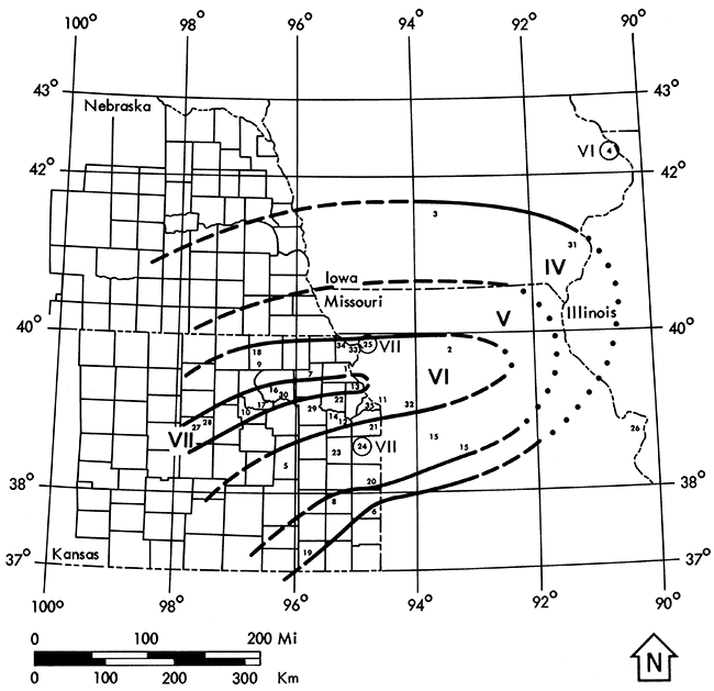
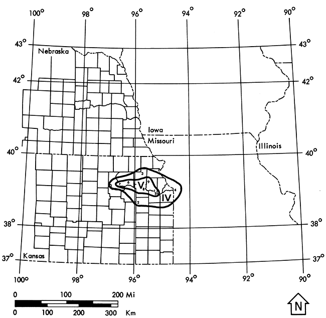
An estimated felt area of 95,000 sq. mi. is also found in Docekal (17). Equally strong felt reports exist from Leavenworth, Paola, Wamego, Louisville, Manhattan, and Solomon, KS. All of these towns, excluding Leavenworth and possibly Paola, were situated in alluvial valleys which may have served to amplify the effects of the shock. Documentation is limited because of the sparse population in 1867. The isoseismal map (Fig. 3) has been constructed with open contours to the west due to lack of reports in that direction.
Figure 3--Isoseismal map of the April 24, 1867 earthquake in Kansas.
(See Figure 4 for location of the reports listed below)
| Lat: 39° 2' Long: 95° 42' | Near: Topeka (see Fig. 2, b) |
| Time: 5:00 a.m. | Felt Area: 8,000 sq.mi. (20,720 sq.km.) (8, 17, 45) |
| Locality | Assigned MM Intensity |
Earthquake Effects |
|---|---|---|
| 1. Buck Creek, KS (Douglas Co.) |
VI | Distinct shock Shook house, rattled dishes (9,36) |
| 2. Burlingame, KS (Osage Co.) |
VI | Rumbling noise Shook houses, windows (9, 36) Some people awakened Motion lasting one minute; came from the west (17) Slight shock (8, 9, 36) |
| 3. Holton, KS (Jackson Co.) |
IV | Rumbling noise, lasted several seconds Windows, stoves, dishes rattled Vibrations of the earth distinctly felt (28) |
| 4. Kansas City, MO (Jackson Co.) |
IV | "Western section of Missouri in the vicinity of Kansas City was startled by an earthquake at 4: 00 a.m." (27) |
| 5. Lawrence, KS (Douglas Co.) |
V-VI | Two distinct shocks felt, lasting one minute each (9, 45, 53) Man living adjacent to city waked up to find dishes rattling At the Hill home: dishes rattled, glass jar broken, family escaped out of doors rapidly (9, 36) |
| 6. Louisville, KS (Pottawatomie Co.) |
IV-V | Stoves, crockery, window panes rattled Door jarred open (9, 35, 36) |
| 7. Manhattan, KS (Riley Co.) |
V | Wooden houses rocked, stone ones quivered (9, 36, 46) Several people awakened (46) |
| 8. Topeka, KS (Shawnee Co.) |
V | Plainly felt in Topeka, light shock Shockwave came from the northwest (conflicts with report in which the motion was SE to NW) (9,36) Observed on the Wakarusa, south of town (9, 36, 53) Felt in the Capitol, the most solidly built structure in town (9, 45) Nearly everyone awakened Shook windows, crockery in the store houses Floors seemed to heave (9) |
| 9. Valley Falls, KS (Jefferson Co.) |
V | People awakened Buildings rocked and quivered (8, 17) Dishes and windows rattled (17) "Shock felt here though not as severely as in Topeka" (66) |
The shock was not felt in Arkansas (17). The epicenter was relocated from Valley Falls (8, 17, 45) to the Topeka vicinity on the basis of the reports shown above. The date of this earthquake is unclear. All accounts state that it occurred between 4 and 5 a.m., but dates of the 5th, 7th, and 8th of November were cited. Multiple events on three days in the same region would have been reported by the press. It is probable that a typographic error exists in the Valley Falls Weekly, New Era (66), which reports that Topeka felt the shock on the 5th. The daily Topeka Commonwealth (9) reported the effects on November 9, presumably the day after the event. Thus, November 8 was the most likely date of occurrence.
Figure 4--Isoseismal map of the November 8, 1875 earthquake in Kansas.
| Lat: 39° 34' Long: 99° 04' | Near: Kirwin |
| Time: -- | Felt Area: -- |
| Locality | Assigned MM Intensity |
Earthquake Effects |
|---|---|---|
| 1. Kirwin, KS (Phillips Co.) |
IV-V ? | "Quite a severe shock was felt at Kirwin, KS" (17) |
There was no reference to this shock in any of the March issues of the Phillips County Herald for that year. The latitude and longitude taken from Docekal (17) place the event in Osborne County, KS which is southeast of the town named in the felt report. Because of the conflicting locations and lack of details or references, this event has not been included on the epicenter map (Fig. 2) and has questionable authenticity.
| Lat: 38° 57' Long: 95° 13' | Near: Lawrence (see Fig. 2, c) |
| Time: 9:00 a.m. | Felt Area: -- |
| Locality | Assigned MM Intensity |
Earthquake Effects |
|---|---|---|
| 1. Lawrence, KS (Douglas Co.) |
II-III | Slight shock felt by several people Sleeping persons (including editor of Lawrence paper) not awakened (37) |
No felt reports have been found from other towns. This event is listed by Docekal (17), but not by Merriam (45) nor Coffman and von Hake (8).
| Lat: -- Long: -- | Near: Kansas City (?) |
| Time: 1:10 a.m. | Felt Area: 45,000 sq.mi. (116,550 sq.km.) (17) |
| Locality | Assigned MM Intensity |
Earthquake Effects |
|---|---|---|
| 1. Kansas City, MO (Jackson Co.) |
IV | Dishes and doors rattled Beds moved (17,27) Effects of the tremor were mostly noticeable in the Westport District (27) |
| 2. Medicine Lodge, KS (Barber Co.) |
III | Slight shock lasting 5 seconds (17) |
Jefferson, Oklahoma reported a severe shock which rocked buildings, making them creak and crack (17). It is unclear whether the source of the widespread effects lay in Kansas or Oklahoma. Therefore, the event is not shown on the epicenter map (Fig. 2).
| Lat: 38° 47' Long: 95° 21' | Near: Baldwin, KS (see Fig. 2, d) |
| Time: -- | Felt Area: -- |
According to Docekal (17) a shock was reported from Baldwin in Douglas County. No details are available. No reports of the disturbance are mentioned in the Emporia Gazette, Lecompton Sun, or Baldwin Ledger for that date. No reference to this event was made by Merriam (45) or by Coffman and von Hake (8).
| Lat: 37.5° Long: 100.2° | Near: Dodge City (see Fig. 2, e) |
| Time: 10:30 p.m. | Felt Area: 2,700 sq.mi. (6,993 sq.km.) (17) |
| Locality | Assigned MM Intensity |
Earthquake Effects |
|---|---|---|
| 1. Dodge City, KS (Ford Co.) |
IV-V | Three distinct shocks (8, 17, 18, 45) Rumbling sound (18) People awakened Windows and dishes rattled (8, 17, 45) |
| 2. Meade, KS (Meade Co.) |
IV-V | Two shocks at 10:06 and 10:09 p.m. Dull rumbling roar accompanied each shock in Artesian Valley where the effects were more noticeable (49) Windows and dishes rattled in lively manner (8, 17, 44, 45) People were awakened (8, 17, 45) |
The epicenter location varies among the standard catalogs (8, 17, 45) between Dodge City and Meade. The former location has been chosen arbitrarily in accordance with Docekal.
(See Figure 5, p. 31, for location of the reports listed below)
| Lat: 39.2° Long: 96.5° | Near: Manhattan (see Fig. 2, f) |
| Time: 6:20 p.m. | Felt Area: 36,000 sq.mi. (93,240 sq.km.) (17) |
Where reports are available, the following information has been included:
| Locality | Assigned MM Intensity |
Earthquake Effects |
|---|---|---|
| 1. Abilene, KS (Dickinson Co.) a) 7:00 p.m. |
V | Slight shock at 7:00 p.m. Rattled dishes Movement plainly perceptible (67) Water in glasses showed motion (45, 67) |
| 2. Alma, KS (Wabaunsee Co.) a) 6:20 p.m. b) lasted 10 sec. c) started from NW |
VI | Walls rocked, floors weaved Windows rattled, chinaware jumped People felt weak in the knees Followed by second shock at 10:30 p.m. which was slight, and caused no alarm (3) Low rumbling sound preceded shock (54) |
| 3. Auburn, KS (Shawnee Co.) |
IV | Stove lids rattled Houses shook Same reports from Dover, in Shawnee Co. (54) |
| 4. Blue Rapids, KS (Marshall Co.) |
IV | Many people felt trembling or rocking Leaves swayed on house plants Not severe In Great Western Mines, 500-600 tons of roof rock fell (7) |
| 5. Cleburne, KS (Riley Co.) |
V-VI | Some dishes broken Some people very much disturbed, thinking an explosion had occurred More severe than at Irving (29) |
| 6. Emporia, KS (Lyon Co.) a) 6:15 p.m. b) 3 shocks lasting 60 sec. c) traveled northward |
V-VI | Many people frightened, several ran outdoors Dishes rattled, houses shook More severe four mi. north of town, lighter to the east, hardly felt south of Emporia (22) Three distinct shocks all over Lyon County No damage reported (22,67) |
| 7. Hope, KS (Dickinson Co.) |
V | Buildings trembled Doors slammed shut in houses (19) |
| 8. Irving, KS (Marshall Co.) a) 6:30 p.m. b) 2 shocks |
IV-V | Rattled dishes on supper table Beds shaken violently Some people quite alarmed Similar reports from Bigelow (29) |
| 9. Junction City, KS (Geary Co.) a) 6:17 p.m. |
VI | Panic--people fled to streets Articles shaken from shelves and tables Windows rattled Plaster knocked from walls (8, 17) |
| 10. Kansas City, MO (Jackson Co.) a) 6:17 p.m. b) 23-60 seconds c) Motion from south and north (27) |
IV | Shook chandeliers Rattled dishes (27, 54) Not severe enough to cause alarm (42) |
| 11. Lawrence, KS (Douglas Co.) |
IV (?) | "No doubt about shaking here, although severer to the west" Did not cause alarm (38) |
| 12. Lincoln, NE (Lancaster Co.) a) 6:30 p.m. |
IV (?) | Shook globes and chandelier fastenings Distinctly felt although no damage was reported (67) |
| 13. Manhattan, KS (Riley Co.) a) 6:15 p.m. b) 2 distinct waves c) SE → NE motion |
VII | Walls cracked (8, 17) People rushed from homes in frenzied fear (36, 38, 45) Brick chimneys dislodged from school, depot, houses (8, 17, 27, 36, 38, 45) Dishes thrown together on tables Houses rocked and swayed (38) Shelf contents shaken to floor (36, 38) Direction of wave motion was SW to NE Persons in the dining room of the Gilett Hotel rushed out into streets Lateral motion followed by vertical movement Aftershock 20 minutes later (36) Vase, lamp or bottle broken in every house (17, 27) Tremor preceded by rumbling sound (8, 17, 36) Aftershock January 23 at 8:00 a.m. (27, 36, 45) |
| 14. St. Joseph, MO (Buchanan Co.) b) 10 sec. c) came from south |
V-VI | Rattled dishes and tinware (27, 38, 42, 67) Detached pictures from wall (38, 42) Frightened small children (27, 38, 67) Shock came from south and lasted ten seconds (54, 67) No serious damage (42) Tables did freakish stunts, floors swayed, dishes danced Plates on racks attached to wall fell to floor (19) |
| 15. Seneca, KS (Nemaha Co.) |
IV | Jarred windows *Rattled dishes (19) |
| 16. Skiddy, KS (Morris Co.) |
? | Most of the wells at Skiddy have gone dry--used to be half full before the earthquake (22) |
| 17. Topeka, KS (Shawnee Co.) a) 6:15 p.m. b) 2 shocks, 3 shocks at Union Pacific Hotel (45) |
V-VI | Roaring sound followed by the shock (8, 17, 36, 45, 54)
Shook houses, windows, doors, dishes (36, 45, 54) Glass lamps shaken Man awakened China thrown from pantry shelves Baby fell from lounge (54) Slight shock resulting in curious inquiries at telephone office (38,67) People filled the streets (53) |
| 18. Valley Falls, KS (Jefferson Co.) |
II-III | Slight but distinct shocks every day or so from January 7-January 23 (27) |
| 19. Wamego, KS (Wabaunsee Co.) |
VI | Plaster shaken from ceilings (8, 17, 19, 38, 42) Things tumbled about generally (38, 42) Pictures shaken from walls Bottles shaken from shelves "The amount of damage will be considerable" (19) |
| 20. Wathena, KS (Doniphan Co.) a) 6:15 p.m. c) N-S motion |
IV-V | Severe earthquake accompanied by rumbling sound noticed here Traveled N-S Houses shaken Dishes rattled (68) |
| 21. Westmoreland, KS (Pottawatomie Co.) |
VI | Plastering jarred off courthouse in places (7) |
| 22. White Cloud, KS (Doniphan Co.) |
II-III | Felt, but "not very severe" (69) |
| 23. Wichita, KS (Sedgwick Co.) b) 3 shocks lasting 3-4 seconds |
II-III | Slight shock felt Three shocks lasting 3-4 seconds (19) |
| 24. Woodbine, KS (Dickinson Co.) |
IV | Dishes rattled in cupboards (19) |
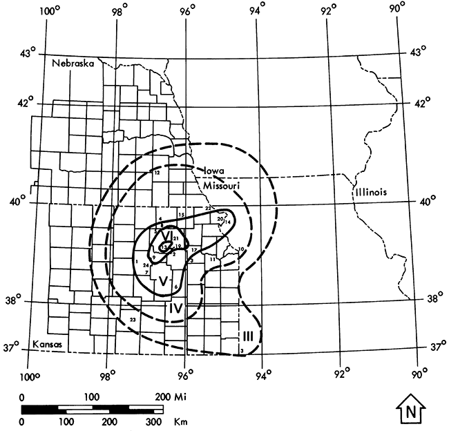
A felt area estimate of 10,000 sq. mi. is also listed by Merriam (45) and Docekal (17). Eight aftershocks were reported in Manhattan (three of these were also felt in Wamego) during the period from January 8th through 23rd (17). Felt reports were found from Leonardville (51), Hickory Grove (51), Walnut Creek (51), Marysville (1), Joplin, MO (42), Salina (67), Minneapolis (67), Clay Center (67), Nebraska City, NE (67), and Syracuse (67). Docekal (17) lists felt reports for Oskaloosa, Herrington, Emporia and Beloit, KS; Plattsmouth, Falls City and Brock NE; and Bethany, MO.
Figure 5--Isoseismal map of the January 7, 1906, earthquake in Kansas.
| Lat: 37° 04' Long: 97° 02' | Near: Arkansas City (see Fig. 2, g) |
| Time: 1:45 a.m. | Felt Area: -- |
An earthquake lasting two seconds awakened people and rattled dishes in Arkansas City (Cowley County), KS (17). The shock was not felt in adjacent towns (17). No new reports were found for this event. Merriam (45) and Coffman and von Hake (8) do not mention it at all.
| Lat: 37° 41' Long: 97° 20' | Near: Wichita (see Fig. 2, h) |
| Time: 10:00 p.m. | Felt Area: 9,500 sq.mi. (24,605 sq.km.) (?) (7) (17) |
| Locality | Assigned MM Intensity |
Earthquake Effects |
|---|---|---|
| 1. Wichita-Riverside District (Sedgwick Co.) |
IV | Shock lasted 4-5 seconds (4, 17, 45, 70) Dishes and windows rattled (4, 70) Rumbling sound was heard (4, 17, 70) Furniture moved (17) |
Merriam (45) lists 9:06 p.m. as the time of the event.
| Lat: 37° 41' Long: 97° 20' | Near: Wichita (see Fig. 2, i) |
| Time: 5:00 a.m. & 8:00 a.m. | Felt Area: 4,000 sq.mi. (?) (10,360 sq.km.) (?) (17) |
| Locality | Assigned MM Intensity |
Earthquake Effects |
|---|---|---|
| 1. N Riverside-Wichita (Sedgwick Co.) |
IV | First shock lasted two seconds Caused houses to tremble The next shock was slightly longer and more violent (70) A loud rumbling noise preceded the shocks (4, 17, 45) *It was difficult to take steps without staggering (4) |
| Lat: 38° 51' Long: 101° 45' | Near: Sharon Springs (see Fig. 2, j) |
| Time: 7:00 a.m. | Felt Area: -- |
At 7:00 a.m., a rumbling sound was heard and a bluish cloud of dust was observed in Smoky Hill Basin, four miles southeast of Sharon Springs (Wallace County), KS. A hole was found to be 50 feet wide, descending conically into darkness. Union Pacific Engineers estimated that 6,000 tons of dirt and rock fell into the hole and disappeared. Pale green water arose from the bottom. Patches of bubbles appeared on the surface and whiffs of sulfur floated up at intervals.
Large cracks, five feet wide in places and several hundred feet long, encircled the hole which grew larger every day. By March 25, the dimensions were 450 feet from east to west; 300 feet from north to south; 150 feet from the east bank to the water line; and 170 feet water depth.
The Niobrara Formation lies 200 feet below the surface. A similar feature, Old Maid's Pool, exists six miles northwest of Sharon Springs. Not the slightest earthquake shock was recorded anywhere in the United States on March 9th. Thus, it is likely that this particular incident is related to collapse and solution in the underlying chalk beds rather than to seismic activity. Docekal (17) lists March 10 as the date of this event, it is believed to be an error.
For further reference, see the following issues of The Western Times, Sharon Springs, KS: March 11, 18, and 25; April 1, 8, 15, and 22, 1926.
| Lat: 38° 21' Long: 97° 41' | Near: McPherson (see Fig. 2, k) |
| Time: 3:30 a.m. | Felt Area: 4,000 sq.mi. (10,360 sq.km.) (?) |
| Locality | Assigned MM Intensity |
Earthquake Effects |
|---|---|---|
| 1. McPherson, KS (McPherson Co.) |
IV-V | Scores awakened Dishes rattled Keystone in a bank fell out Deep rumbling sounds heard during the vibration (17, 27, 45, 60) |
No new reports were found
| Lat: 39° 55' Long: 95° 20' | Near: White Cloud (see Fig. 2, l) |
| Time: 11:25 a.m. | Felt Area: 300 sq.mi. (777 sq.km.) (17, 45) |
| Locality | Assigned MM Intensity |
Earthquake Effects |
|---|---|---|
| 1. White Cloud, KS (Doniphan Co.) |
VI | Houses rocked People fled quickly to streets (8, 17, 45, 60) All loose articles rattled (17) |
No account of this earthquake is found in the Kansas City Times, Kansas City Star, or Lawrence Daily Journal for this date. Docekal (17) reports that Highland, KS and Oregon, MO felt the shock.
| Lat: 39.5° Long: 98.1° | Near: Beloit (see Fig. 2, m) |
| Time: 8:15 a.m. | Felt Area: -- |
| Locality | Assigned MM Intensity |
Earthquake Effects |
|---|---|---|
| 1. Beloit, KS (Mitchell Co.) |
IV | Shock lasted 40 seconds Floors seemed to stir and sway under the feet Not severe enough to disturb objects Steam pipes quivered (6) Windows shook, dishes rattled (6, 17, 45) |
No reports were found from other towns, thus indicating an extremely local felt area.
| Lat: 39.0° Long: 96.6° | Near: Manhattan (see Fig. 2, n) |
| Time: 4:00 a.m. and 5:00 a.m. | Felt Area: 15,000 sq.mi. (38,850 sq.km.) (17, 45) |
Two slight shocks awakened residents of Manhattan and Junction City. Windows and dishes rattled although no damage occurred. The trembling was felt at Wakefield, Wheaton, Eskridge, and towns in the triangle between them (17, 25, 32, 45). No new details were found.
| Lat: 39.2° Long: 96.5° | Near: Junction City (see Fig. 2, n) |
| Time: 3:25 p.m. | Felt Area: 8,000 sq.mi. (20,720 sq.km.) (17,45) |
Two light shocks were felt in Manhattan, Junction City, and McFarland at 3:25 p.m. They were more intense than those of September 23rd (57). Abrupt bumping, rattling of windows and cooking utensils, and other sounds like thunder were reported (17, 25, 45, 57). Council Grove, Concordia, Chapman, Clay Center, Emmett, St. George, and Wamego also felt the tremor (25, 45, 55). Father Joliat's seismic records in Florissant, MO placed the epicenter near Junction City (32). The shock was also recorded on the seismograph at Lawrence according to Merriam (45).
| Lat: 39.0° Long: 96.8° | Near: Junction City (see Fig. 2, p) |
| Time: --- | Felt Area: -- |
A sight shock was felt in Junction City (8, 17, 45): probably an aftershock of the October 21st event. No further details were found.
| Lat: 37° 11' Long: 99° 46' | Near: Ashland (see Fig. 2, q) |
| Time: 10:20 a.m. | Felt Area: -- |
| Locality | Assigned MM Intensity |
Earthquake Effects |
|---|---|---|
| Ashland, KS (Clark Co.) |
IV | Three distinct ground swells were felt in rapid succession Preceded by a peculiar whistling sound (63) |
Docekal (17) and Merriam (45) refer to this event as a local shock. A 1969 photograph of an earth rupture possibly associated with this earthquake appears in a 4-H manual, "Exploring the World Through Geology," authored by Harold E. Jones. Frank Wilson submitted an open file memo concerning this rupture to the Kansas Geological Survey in 1973. The location of the fracture is approximately six miles east of Ashland in a pasture. The fracture is 200 yards long, trending N 30° E with an estimated age of less than 55 years. It may be associated with subsidence rather than the actual earthquake. The site was visited in May 1976 by Don Steeples, Pieter Berendsen, and Tom McClain of the K.G.S. staff. A linear depression several hundred feet long was still visible. It was their unanimous opinion that the fracture was associated with solution phenomena. There was no visible offset to indicate that the fracture was earthquake related.
| Lat: 39° 11' Long: 96° 34' | Near: Manhattan (see Fig. 2, r) |
| Time: 2:02 a.m. | Felt Area: 1,000 sq.mi. (2,590 sq.km.) (17, 45) |
| Locality | Assigned MM Intensity |
Earthquake Effects |
|---|---|---|
| 1. Council Grove, KS (Morris Co.) |
V | Beds shook (25) |
| 2. Manhattan, KS (Riley Co.) |
V | Buildings shook Windows rattled Many people awoke (17, 45, 57) No damage reported (45, 57) |
Felt reports were received from Wamego, McFarland, and Junction City (25,45).
| Lat: 39.1° Long: 94.7° | Near: Turner (see Fig. 2, s) |
| Time: 12:18, 1:07, and 1:15 a.m. | Felt Area: 300 sq.mi. (777 sq.km.) (17) |
| Locality | Assigned MM Intensity |
Earthquake Effects |
|---|---|---|
| 1. Kansas City, MO (Jackson Co.) |
V | Houses shook violently Dishes and small articles broken Several people awakened Pictures and bric-a-brac fell (33) Dishes rattled, pictures swung (45) |
| 2. Leeds, MO (Jackson Co.) |
V-VI | Telephone operators were almost shaken from their chairs (33) |
| 3. Merriam, KS (Johnson Co.) |
VI | Shock lasted 30 seconds Pictures were thrown from walls Dishes broken People fled to the streets It felt as though beds were lifted and then dropped (33) |
| 4. Turner, KS (Wyandotte Co.) |
VI | A family of four was thrown from beds Furniture was overturned (33) |
Father Joliat placed the epicenter near Turner, KS. The Lawrence Seismograph did not record the shocks (27, 33) although a slight disturbance was indicated on the records according to R. C. Moore (39). St. Louis and Denver instruments did not record disturbances at all. No explosion is known to have occurred (39). The shock was not felt in Topeka, but seemed to be confined to a 10-mile area (58). Felt reports exist for Bonner Springs and Overland Park, KS (45). On the basis of the strong felt reports from Turner, Merriam, and Leeds a revised MM value of VI has been assigned to this event.
| Lat: 39.0° Long: 99.6° | Near: Ellis (see Fig. 2, t) |
| Time: 6:15 p.m. | Felt Area: 2,000 sq.mi. (?) (5,180 sq.km.) (17) |
Ellis and Trego counties were shaken by a slight earthquake at 6:15 p.m. Windows were shattered in a farmhouse 15 miles north of Ellis (17, 45, 59). The interpretation of the significance of this latter report accounts for the various MM ratings given for this event. Taken literally, the report justified a MM intensity VI. Docekal (17) chose MM V and Merriam lists a conservative MM III (?). Recently, it has been learned that residents of Bogue in Graham County also felt this earthquake (personal communication from Don Steeples, K.G.S. geophysicist).
| Lat: 39° 50' Long: 99° 54' | Near: Norton (see Fig. 2, u) |
| Time: 11:00 a.m. | Felt Area: 5,700-6,000 sq.mi. (14,763-15,540 sq.km.) (17) |
A shock was felt in Norcatur, Norton, Oronoque, KS and Beaver City, Hendley, Oxford, and Stamford, NE (17, 45, 48). In Norton, windows and dishes rattled, phone bells jingled, houses swayed, and some people ran outdoors (17, 45). Many people in Kansas felt sick as a result of the shock (17). Some believe it may have been caused by an exploding meteor (48). The occurrence of instrumentally recorded epicenters in this vicinity in 1961, 1977, and 1978 lends credence to its being a tectonic earthquake.
| Lat: 38° 51' Long: 99° 20' | Near: Hays City (see Fig. 2, v) |
| Time: 4:00 a.m. | Felt Area: -- |
| Locality | Assigned MM Intensity |
Earthquake Effects |
|---|---|---|
| 1. Hays City, KS (Ellis Co.) |
V | Windows and dishes shook A mop bucket jumped (21, 24) Scores of people awoke (17, 21, 24, 45) |
The shock was felt in Stockton and Plainville also (17, 45). The fact that many sleepers were awakened suggests a MM intensity of V rather than III (?) (45) or IV (17).
| Lat: 37° 42' Long: 97° 20' | Near: Beechwood (see Fig. 2, w) |
| Time: 9:00-10:00 p.m. | Felt Area: -- |
Six tremors caused ripples in goldfish bowls in Beechwood, KS about five miles east of Wichita. Houses reportedly trembled (17, 45). No new details were found.
| Lat: 37° 15' Long: 98° 45' | Near: Barber County (see Fig. 2, x) |
| Time: 5:50 a.m. | Felt Area: 16,000 sq.mi. (41,440 sq.km.) (14) |
According to Dellwig (14) the felt area was about 16,000 sq. mi. and the depth to focus was 20 miles (32 km.) (?). Throughout the central zone, a rumbling sound preceded or accompanied the vibration. The maximum intensity attained was at Coats, KS and Alva, OK where objects were overturned and knocked from shelves. Small pieces of plaster fell from walls already in poor condition. Other towns reported movement of beds, shaking of floors, rattling windows and dishes, and awakening of residents. A complete report of the earthquake including an isoseismal map has been published by Dellwig (14).
| Lat: 39.9° Long: 100.0° | Near: Norton (see Fig. 2, y) |
| Time: 3:16 p.m. | Felt Area: 1,400 sq.mi. (3,626 sq.km.) (17) |
| Locality | Assigned MM Intensity |
Earthquake Effects |
|---|---|---|
| 1. Alma, NE (Harlan Co.) |
V | Water bounced in a tank Stove rattled (17) |
| 2. Beaver City, NE (Furnas Co.) |
V | Canned goods fell off shelves (17) |
| 3. Norton, KS (Norton Co.) |
V | Buildings shook Water bounced in stock tanks Noise like an explosion was heard Dishes rattled Furniture was set in motion (61) |
A tremor lasting 10-12 seconds was felt from Norton 18 miles west to Norcatur and 38 miles northeast to Alma, NE. Dr. James Peoples recorded a small earthquake on the Lawrence seismograph (61). The focus was reported at 25 km depth. The center of activity was placed 10-15 miles north of Norton (17). Docekal (17) reports that a MM intensity V was observed at Almena, KS.
| Lat: 39° 21' Long: 94° 13' | Near: Excelsior Springs, MO (not shown in Fig. 2) |
| Time: 6:20 and 7:00 a.m. | Felt Area: 10,000 sq.mi. (25,900 sq.km.) (15) |
On Christmas morning, two shocks were felt along the Kansas-Missouri border. The disturbances registered at nine seismograph stations and the focal depth was calculated to be 20 or 30 km. Reports from Lawson and Kearny, MO, near the center of activity, included cracked plaster, fallen objects, and many people awakened (15, 17). The epicenter has been located five miles north of Excelsior Springs, MO on the basis of seismic records. A complete report of the events has been published by Dellwig (15).
We owe special thanks to the following people from the Kansas Geological Survey for their help in preparing this paper:
In addition, we are grateful to Ruth Say (Wabaunsee County Register of Deeds) and Bob Knecht (Federal Archives and Records Center, Kansas City, Missouri) for taking time to personally search their records for specific information pertaining to earthquake reports.
1. Advocate-Democrat, Jan. 12, 1906, Marysville, KS.
2. Algermissen, S.T. (1969) Seismic Risk Studies in the united States: Proceedings of the Fourth World Conference on Earthquake Engineering, vol. 1, pp. 14-27, Santiago, Chile, NOAA reprint.
3. Alma Signal, Jan. 12, 1906, Alma, KS.
4. Arkansas City Traveler, May 1, 1925, Arkansas, KS.
5. Atchison Daily Champion, Apr. 25, 1867, Atchison, KS.
6. The Beloit Daily Call, Nov. 8, 1928.
7. Blue Rapids Times, Jan. 11, 1906, Blue Rapids, KS.
8. Coffman, J.L. and C.A. von Hake (1973) Earthquake History of the United States: Nat'l Oceanographic & Atmosph. Adm., Boulder, CO.
9. Commonwealth, Nov. 9, 10, 1875, Topeka, KS.
10. Commonwealth, Apr. 24, 1877, Topeka, KS.
11. Condra, G.E. (1927) The Stratigraphy of the Pennsylvanian System in Nebraska: Nebraska Geological Survey, Bulletin 1, 2nd ser. pp. l-29l.
12. Daily Free Press, Apr. 24, 1867, Atchison, KS.
13. Daily Free Press, Apr. 25, 1867, Atchison, KS.
14. Dellwig, L.F. (1956) The Barber County Earthquake of Jan. 6, 1956, Kansas Geological Survey, Bulletin 119, Part 5, pp. 175-185. [available online]
15. Dellwig, L.F. (1962) The Earthquakes of Dec. 25, 1961, Kansas Geological Survey, Bulletin 157, Part 1, pp. 3-12. [available online]
16. Dewey, Legends of the Wheat Country, p. 65, Kansas State Historical Society, Topeka, KS.
17. Docekal, Jerry, (1970) Earthquake History of the Stable Interior: University of Nebraska unpublished PhD. dissertation.
18. Dodge City Democrat, Oct. 28, 1904, Dodge City, KS.
19. Earthquake Clipping File, State Historical Society Library, Topeka, KS.
20. Earthquakes in Kansas, Kansas Historical Collections (1911-1912) Vol. VII, p. 208.
21. Ellis County News, Sept. lO, 1942, Hays, KS.
22. Emporia Gazette, Jan. 8, 1906, Emporia, KS.
23. Globe-Republican, Jan. l8, 1906, Dodge City, KS.
24. Hays Daily News, Sept. 10, 1942, Hays, KS.
25. Heck, N.H. (193l) U.S. Earthquakes, 1929: U.S. Coast & Geodetic Survey, Series No. 511, pp. 8-9.
26. Heck, N.H. (1947) Earthquake History of U.S., Part 1, Continental U.S.: U.S. Coast & Geodetic Survey, Series No. 609, pp. 1-83.
27. Heinrich, Ross R. (194l) Contribution to earthquake history of Missouri, Bulletin Seismological Society America, vol. 3l, no. 3, pp. l87-224.
28. Holton Recorder & Express, Nov. 11, 1875, Holton, KS.
29. Irving Leader, Jan. l2, 1906, Irving, KS.
30. Joliat, J.S. (1929) The Kansas Earthquake of 1929: Bulletin Seismological Society America, vol. 19, No. 14, pp. 237-238.
31. Junction City Union, Apr. 27, 1867, Junction City, KS.
32. Kansas City Star, Sept. 25, 1929, Kansas City, MO.
33. Kansas City Star, Aug. 9 & 10, 1931, Kansas City, MO.
34. Kansas Radical, Apr. 27, 1867, Manhattan, KS.
35. Kansas Reporter, Nov. 11, 1875, Louisville, KS.
36. Kansas State Historical Society Transactions (1912) vol. 12, pp. 121-131.
37. Lawrence Daily Journal, May 20, 1881, Lawrence, KS.
38. Lawrence Daily Journal, Jan. 8, 1906, Lawrence, KS.
39. Lawrence Daily Journal-World, Aug. 10, 1931, Lawrence, KS.
40. Leavenworth Daily Conservative, Apr. 25, 1867, Leavenworth, KS.
4l. Leavenworth Times, Apr. 25, 1867, Leavenworth, KS.
42. Lecompton Sun, Jan. l2, 1906, Lecompton, KS.
43. Lykins, H.R. (l867) American Journal Science, vol. 95, no. 130, p. 132.
44. Meade County Globe, Oct. 27, 1904, Meade, KS.
45. Merriam, D.F. (1956) History of Earthquakes in Kansas, Bulletin Seismological Society America, vol. 46, no. 2, pp. 87-96.
46. Nationalist, Nov. 12, 1875, Manhattan, KS.
47. Newman, Frank (1932) U.S. Earthquakes, 1931: U.S. Coast & Geodetic Survey, Series No. 553.
48. Newman, Frank (1935) U.S. Earthquakes, 1931: U.S. Coast & Geodetic Survey, Series No. 579.
49. Parker, John D. (l867) Memoranda of the earthquake of Apr. 24, 1867: Kansas Collection of Spencer Research Library, Lawrence, KS.
50. Petersen, W.J. (1933) Earthquakes in Iowa, The Palimpset, State Historical Society of Iowa, vol. XIV, no. 4, pp. l60-l74.
51. Randolph Enterprise, Jan. 11, 1906, Randolph, KS.
52. Reid, H.F., (l882) American Journal Science, vol. 123.
53. Tabor, Milton (1928) "Earthquakes in Kansas", This Day in Kansas History, p. 141: State Historical Society, Topeka, KS.
54. Topeka Capital, Jan. 8, 1906, Topeka, KS.
55. Topeka Capital, Jul. 22, 1925, Topeka, KS.
56. Topeka Capital, Apr. 24, 1929, Topeka, KS.
57. Topeka Capital, Dec. 8, 1929, Topeka, KS.
58. Topeka Capital, Aug. 9 & 10, 1931, Topeka, KS.
59. Topeka Capital, Jan. 29, 1932, Topeka, KS.
60. Topeka Capital, May 11, 1955, Topeka, KS.
61. Topeka Capital, Apr. 14, 1961, Topeka, KS.
62. Topeka Journal, Jul. 19, 1929, Topeka, KS.
63. Topeka Journal, Nov. 28, 1929, Topeka, KS.
64. Topeka Journal, Jan. 6, 1956, Topeka, KS.
65. Topeka Journal, Aug. 24, 1956, Topeka, KS.
66. Valley Falls New Era, Nov. 13, 1875, Valley Falls, KS.
67. Wathena Times, Jan. 12, 1906, Wathena, KS.
68. Wathena Weekly Reporter, Jan. 12, 1906, Wathena, KS.
69. White Cloud Globe, Jan. 11, 1906, White Cloud, KS.
70. Wichita Morning Eagle, May 27 and July 27, 1919, Wichita, KS.
71. Wilder, D.W. (l886) The Annals of Kansas 154l-1885, Topeka, KS, pp. 456-777.
72. Williams, Wm. G. (1867) American Journal Science & Arts, 2nd Series, vol. 44, no. 130, p. 132.
Kansas Geological Survey
Placed on web Dec. 23, 2015; originally published April 1978.
Comments to webadmin@kgs.ku.edu
The URL for this page is http://www.kgs.ku.edu/Publications/Bulletins/EG2/index.html