Kansas Geological Survey, Bulletin 157, Part 1, originally published in 1962
Originally published in 1962 as Kansas Geological Survey Bulletin 157, Part 1. This is, in general, the original text as published. The information has not been updated.
On December 25, 1961, at 6:20 a.m. and at 7:00 a.m., northwestern Missouri and northeastern Kansas felt the effects of earthquakes centering approximately 8 km (5 mi) north of Excelsior Springs, Missouri. The shocks originated at depths of 20 to 30 km (12 to 18 mi), within the continental granitic layer. The intensity of the second and stronger shock was V. Motion of individuals and objects was perceptible, but damage was limited to minor cracking of plaster.
At approximately 6:20 a.m. and at 7:00 a.m. on December 25, 1961, earthquakes centering about 8 km (5 mi) north of Excelsior Springs, Missouri, were felt throughout northwestern Missouri and northeastern Kansas in an area roughly within a radius of 112 km (70 mi) of the epicenter. Early reports placed the shocks in western Missouri between Kansas City on the north and Joplin and Springfield on the south. Confirmation of the occurrence of an earthquake in northwestern Missouri first came from seismological stations at Saint Louis University and the University of Kansas. The second shock was reported as the stronger of the two, and this was confirmed by the seismological records.
First reports, suggesting disturbance in a long narrow belt between Kansas City and Joplin, prompted a canvas by mail to determine effects of the earthquakes. On December 27 and 28, approximately 700 questionnaires were mailed to postmasters, police chiefs, newspaper editors, and geologists in the area in hopes of determining the intensity pattern. By January 16, 492 questionnaires had been returned and an additional 128 unsolicited letters had been received. This information, supplemented by some field investigation, was the basis for preparation of isoseismal maps (Fig. 1, 2). Maximum intensity of the second and stronger shock was V. Zone V is characterized by "felt by nearly everyone; many awakened, some dishes, windows, etc., broken; a few instances of cracked plaster; unstable objects overturned, disturbance of trees, poles, and other tall objects sometimes noticed, pendulum clocks may stop" (Wood and Neumann, 1931, p. 282). The epicenter as plotted from this investigation closely correlates with the epicenter as determined from seismic information from nine stations.
Without the cooperation of many individuals, too numerous to name, this work could not have been completed. Newspapers made it known to their readers that information was desired, and some papers printed the questionnaire. This help was directly responsible for many of the unsolicited letters. Many postmasters, to whom most of the questionnaires were addressed, made considerable effort to give a cross section impression of their patrons' reactions. Thanks also go to several graduate students at the Department of Geology of the University of Kansas and to several staff members of the State Geological Survey of Kansas, who helped process mail and who field-checked critical areas. We especially thank Virgil B. Cole of Wichita, Kansas, for permission to reproduce part of an unpublished basement map of the area affected by the earthquakes (Fig. 3), and J. A. Peoples for help in interpretation of records and for obtaining information from other stations.
In the midcontinent area, normally regarded as tectonically stable, numerous small shocks have occurred during historic time. Earthquakes that have been felt in eastern Kansas and western Missouri are as follows (Merriam, 1956):
| Date | Epicenter | Maximum intensity at epicenter |
|---|---|---|
| December 16, 1811 | 36.6° N, 89.6° W, New Madrid, Mo. | X |
| January 2p, 1812 | 36.6° N, 89.6° W, New Madrid, Mo. | X |
| February 7, 1812 | 36.6° N, 89.6° W, New Madrid, Mo. | X |
| April 24, 1867 | 39.5° N, 96.7° W, Manhattan, Kans. | VIII |
| November 8, 1875 | 39.3° N, 95.5° W, Valley Falls, Kans. | V |
| November 15, 1877 | 41° N, 97° W, eastern Nebraska | VII |
| November 18, 1878 | 36.7° N, 90.4° W, southeastern Missouri | VII |
| October 31, 1895 | 37° N, 89.4° W, Charleston, Mo. | VIII-IX |
| December 2, 1897 | Most noticeable near Westport, Mo. | III |
| January 24, 1902 | 38.6° N, 90.3° W, Missouri | VI-VII |
| January 7, 1906 | 39.3° N, 96.6° W, Manhattan, Kans. | VII-VIII |
| September 27, 1909 | 39° N, 87.7° W, Indiana | VIII |
| April 9, 1917 | 38.1° N, 90.6° W, Eastern Missouri | VI |
| July 30, 1925 | 35.4° N, 101.3° W, Texas Panhandle | VI |
| August 9, 1931 | Probably near Turner, Kans. | IV |
| March 1, 1935 | 40.3° N, 96.2° W, Tecumseh, Neb. | VI-VII |
| November 23, 1939 | 38.2° N, 90.1° W, Griggs, Ill. | V |
| April 9, 1952 | 35.4° N, 97.8° W, Oklahoma City, Okla. | VII |
The coincidence of points of origin and the similarity of areas affected permit discussion of the two earthquakes together.
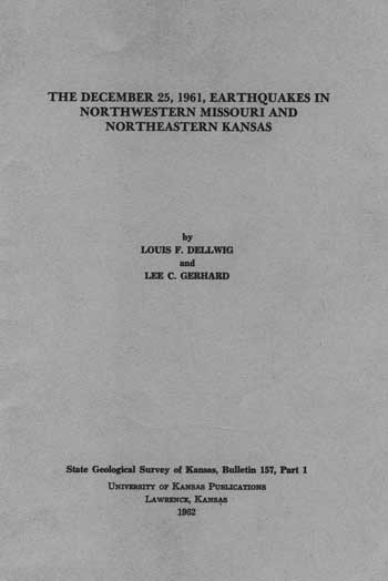
Area AffectedThe 6:20 shock, which had a maximum intensity of IV, was perceptible over an area of approximately 21,500 sq km (8,300 sq mi), the zone of maximum intensity (IV) being confined to Ray and Clay counties, Missouri, between latitude 39.2° and 39.5° N and longitude 93.8° and 94.6° W. The area in which the shock was perceptible is approximately circular, but the zone of maximum intensity is slightly elongate northeast and off set to the southwest of the center (Fig. 1).
Figure 1--Isoseismal map of eastern Kansas and western Missouri showing area affected by earthquake of 6:20 a.m., December 25, 1961. Roman numerals indicate intensity according to Modified Mercalli Intensity Scale.
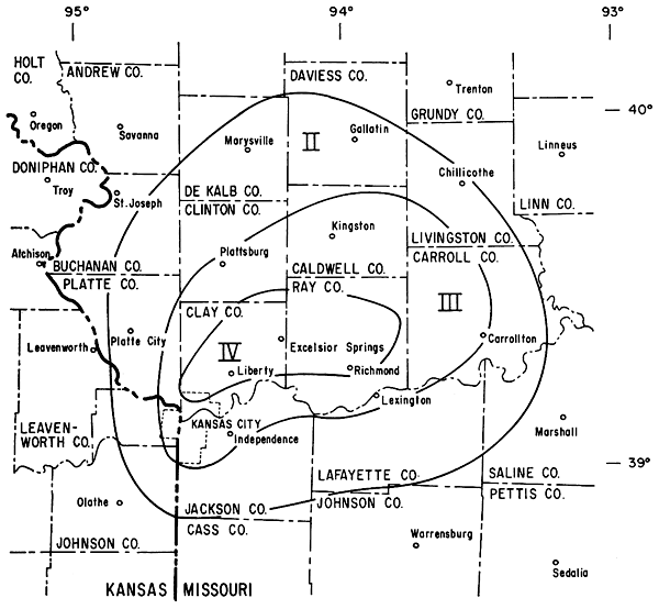
The second shock, at approximately 7 a.m., had a maximum intensity of V but in the lower range of that grade. It was felt over an area of approximately 25,500 sq km (9,745 sq mi), but there were two separate small zones of maximum intensity centering around Kansas City (latitude 39.1° N and longitude 94.6° W) and around Lawson (latitude 39.4° N and longitude 94.2° W) (Fig. 2). These two zones of intensity V and the surrounding zone of intensity IV are, as in the 6:20 a.m. shock, displaced to the southwest in the roughly circular area in which the earthquake was perceptible.
Figure 2--Isoseismal map of eastern Kansas and western Missouri showing area affected by earthquake of 7:00 a.m., December 25, 1961. Roman numerals indicate intensity according to Modified Mercalli Intensity Scale.
The epicentral area lies within the Forest City basin on the northwest flank of the Ozark Dome, in an area underlain by nearly horizontal Pennsylvanian and older rocks. In the vicinity of Excelsior Springs this sedimentary sequence is approximately 2,500 feet thick and is locally overlain by glacial deposits as much as 100 feet thick.
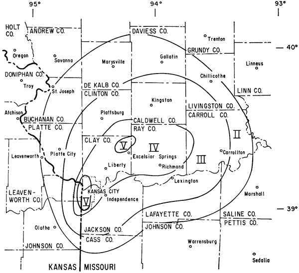
Not even a superficial relationship between the epicenters and any major structural feature can be established. The calculated depths of the earthquakes are not conducive to establishment of a relationship between "minor" basement features and foci (points of origin in depth), although such a relationship seemingly is a distinct possibility. Virgil B. Cole, extending his Precambrian basement map of Kansas (Cole, in press) into adjacent states, shows a series of northwest-trending features in western Missouri (Fig. 3). Several features are definitely bounded by faults, which have been mapped either in surface or subsurface rocks. Areas of maximum intensity for the 7:00 a.m. earthquake lie on the flanks of such structures, and are suggestive of faulting along them in a manner similar to that which has been established along parallel down-faulted blocks (grabens) in southwestern Missouri and southeastern Kansas. The intensity V zone (7: 00 a.m. shock) centering in Kansas City may be exaggerated because of the greater number of reports from this area of greater population density and perhaps should be disregarded. To do so, however, would not detract from the possibility of the second area of intensity V being associated with faulting along the basement trough that trends northwestward through Excelsior Springs and on the flank of which is superimposed the epicenter.
Figure 3--Basement configuration in vicinity of northeastern Missouri earthquakes of December 25, 1961. Zones of intensity V show areas of maximum intensity relative to basement features (from unpublished map by Virgil B. Cole). Contour interval 100 feet.
The epicenter as estimated from intensity distribution is approximately 8 km (5 mi) north of Excelsior Springs, Missouri (latitude 39.4° N, longitude 94.2° W). J. A. Peoples (personal communication) found that ". . . an epicenter position of 39.4° N, 94.2° W is reasonably consistent with reported seismic arrival times for seismograph stations at Lawrence and Manhattan, Kansas; Rolla, Florissant, and St. Louis, Missouri; Fayetteville, Arkansas; Tulsa, Oklahoma; Dubuque, Iowa; and Bloomington, Indiana. Although this is a preliminary estimate, it would be difficult to reconcile a shift of more than 10 km from this position." Preliminary determination by the Coast and Geodetic Survey (January 8, 1962) placed the epicenter in the vicinity of Martin City (latitude 38.9° N, longitude 94.6° W) in western Missouri, south of Kansas City. No reports of the earthquake being felt in the vicinity of the epicentral determination of the Coast and Geodetic Survey were reported. Shocks recorded at Lawrence are as follows:
| Time of arrival (Greenwich Civil Time) | |||
|---|---|---|---|
| iP | 12 | 20m | 15.4s |
| iS | 12 | 20 | 27.7 |
| iP | 12 | 58 | 34.0 |
| iS | 12 | 58 | 46.5 |
| (Interpretation by J. A. Peoples) | |||
The Lawrence station is approximately 92 km (60 mi) from the epicenter. The hypocentral times (time of origin) are 12h 19m 55s, and 12h 58m 14s, Greenwich Civil Time.
Questionnaires and field study indicate a maximum intensity of IV (Modified Mercalli Intensity Scale of 1931) for the first shock (6:20 a.m.), and a maximum intensity of V, but in the lower range of grade V, for the second. The characteristic effects of earthquake activity in intensity zones I-V as defined by this scale (abridged) are listed below (Wood and Neumann, 1931, p. 282).
A maximum intensity of IV was delimited for the 6:20 a.m. earthquake in Ray and Clay counties, but more restricted zones of intensity V (Kansas City, Greenville-Lawson) could be isolated for the 7: 00 a.m. shock. Although the zone of greater intensity at Kansas City is anomalous to the overall distribution of effect (giving full consideration to the volume of correspondence from this area), there is no doubt it is justifiably isolated from the area of intensity V to the northeast.
The depth of focus has been computed using Gutenberg's formula (Gutenberg and Richter, 1942, p. 174) 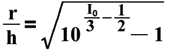 (see p. 9 of book) where r is radius to limit of perceptibility, I0 is maximum intensity, and h is depth of focus. For the first earthquake r is about 88 km (55 mi) and I0 is 4; therefore, the depth of focus is estimated at about 35 km (22 mi). The second shock shows a slight increase in the radius of perceptibility to 112 km (70 mi) and I0 is 5; depth of focus is therefore computed as approximately 25 km (16 mi). Seismic data from the Lawrence station do not aid in the determination of the depth of focus but indicate only that the hypocenter was not below the granite. Inasmuch as the limit of perceptibility cannot be determined precisely, and inasmuch as intensity of the 7:00 a.m. shock reached only into the lower range of grade V, depth of focus could reasonably be approximately the same for both shocks, at about 30 km (19 mi). Because of unknown factors involved, it can be concluded only that they occurred near the base of the granite at a depth of 20 to 30 km (12 to 19 mi). The U.S. Coast and Geodetic Survey reports the depth for the first earthquake at about 25 km (16 mi) and of the second at about 20 km (12 mi); these figures agree reasonably well with other depth determinations.
No warning foreshocks preceded the earthquakes nor were there any aftershocks.
Although isolated reports of ground motion are not unexpected, and most can be attributed to some other coincidental activity, worthy of note are reports from Jasper, Newton, Lawrence, and Christian counties, Missouri, and from Vernon and St. Clair counties, Missouri, and Crawford County, Kansas. Both areas are regions where faults have been identified in both surface and subsurface rocks. Movement along these faults may have been triggered by release of stress as a result of the earthquake activity northeast of Kansas City. Of necessity, because of the small amount of effective energy available as far as 240 km (150 mi) from the epicenter, the earthquake activity could provide only a small triggering force in a region already under stress.
The first earthquake was felt most strongly in the vicinity of Rockingham, Vibbard, Kearney, and North Kansas City, Missouri. Areas of maximum intensity for the second shock are centered around Kearney and Lawson and around Kansas City, Missouri. Throughout these areas, noises associated with the earthquakes were reported. They were described variously as jets crashing the sound barrier, explosions, roars, muffled booms, thunder, heavy trucks passing, heavy blasting, or fast freight trains. The occurrence of sound, however, is not critical for interpretation of intensity. Rapid ground vibration generates these noises, and the frequency of vibration may be below the threshold of hearing for some individuals but not for others. Different persons thus would be expected to react differently to the same vibrations. Other differences in reaction of individuals within a single isoseismal zone are also expected (Wood and Neumann, 1931, p. 278):
"To evaluate intensity critically account must be taken of duration of shaking; nature of ground underneath locality and whether surface is level, gently sloping or steep; whether observers were outdoors, or indoors, in what kind of structure, on what floor, whether quiet or active, and if active how occupied; also whether the motion is rapid or slow, simple or complex, and whether it begins gradually or abruptly. . . ."
For the most part, observations within isoseismal zones correspond with descriptions in the Modified Mercalli Scale. Specific observations are recorded here for areas within the zones of maximum intensity in order to better define the extent of the activity.
Lawson, Missouri--Many residents felt both shocks; some reported being awakened by the first, and a few by the second. The second earthquake was generally conceded to be the stronger. Of the few residents questioned, three reported cracked plaster, all in relatively new homes. Rattling of dishes and windows was common, and movement of unstable objects was detected.
Vibbard, Missouri--An aluminum trailer house, set on concrete blocks, swayed and banged against a porch adjacent to the trailer.
Liberty, Missouri--A 4-inch water main seemingly was broken during the second shock, but the break could have been caused by an exceptionally heavy truck passing over the area. The water department was notified of the break at 7:20 a.m. Dishes rattled throughout the area, and pictures moved on walls.
Kearney, Missouri--Most residents were fully aware of the earthquakes. Many were awakened; some reported shaking of beds. Several who went out of their residences reported seeing neighbors also checking adjacent areas.
Excelsior Springs, Missouri--Reports from Excelsior Springs indicate a lesser effect than in Kearney and Lawson. Some but not most persons reported being awakened by an explosion, not by the shock alone. Many, used to much local blasting, assumed another large explosion at the quarry.
Kansas City, Missouri--The major effect was produced by the second shock. Several residents reported cracked plaster, one reported cracked windows, one a cracked basement, one a cracked patio, and several reported that windows and doors became difficult to open or close. An individual who was sitting in a chair at the time of the shock described his reaction as similar to that when sitting in a car struck from behind. In some houses waterpipes chattered, walls creaked, bird cages rattled, and small bells rang, and pictures were swung from position. In several homes, sand from pre-existing cracks in plaster was shaken onto the floor. Several movements of furniture were reported, including a large chandelier in motion. Coffee was seen sloshing in cups. Letters from the Kansas City area were numerous, the interest of residents typically expressed as follows:
Dear Dr. Dellwig:
My name is John R. Taylor. I am 9 years old. I live at 7418 Jarboe, Kansas City 14, Mo. My house is a 2-story frame structure. The ground underneath is clay. I happened to be awake on Christmas morning about 7:00 when I felt the house vibrate. The quake lasted from 5 to 7 sec. The tremor shook the bookcase about 1 1/2 inches out of place. I was resting near the side of my bed, and it shook me out of bed almost! Although it was slightly large, you could not tell anything had happened unless you felt the tremor, for no noticeable damage had been done. I was the only one in my family who noticed it. I felt only the second one.
Yours truly,
JOHN R. TAYLOR
Kansas City, Kansas--A Christmas tree was tipped over in Prairie Village. Other reports from that area included reference to ornaments shaken from Christmas trees, a chandelier moving, beds rocking, water sloshing in a glass, and bottles and other unstable objects being rattled. In Overland Park a nightstand rattled on the floor, other furniture vibrated, and a small figurine was overturned.
The earthquakes of December 25, 1961, were centered in Ray and Clay counties, in western Missouri. Maximum intensity in the epicentral area during the first shock (6:20 a.m.) was IV and during the second shock (7:00 a.m.) was V. Both earthquakes were felt over an area of maximum radius of approximately 112 km (70 mi). Depth of focus was 20 to 30 km (12 to 19 mi). No relation with any major structural feature can be established, but there is a suggestion of a relationship with possible basement faults. No damage other than minor cracking of walls can be definitely attributed to the earthquakes.
Cole, V. B., in press, Configuration of Precambrian basement rocks in Kansas: Kansas Geol. Survey Oil and Gas Invest. 26, map.
Gutenberg, B., and Richter, C. F., 1942, Earthquake magnitude, intensity, energy, and acceleration: Seismol. Soc. America Bull., v. 32, p. 163-191.
Merriam, D. F., 1956, History of earthquakes in Kansas: Seismol. Soc. America Bull., v. 46, p. 87-96.
Wood, H. O., and Neumann, Frank, 1931, Modified Mercalli Intensity Scale of 1931: Seismol. Soc. America Bull., v. 21, p. 277-283.
Kansas Geological Survey, Geology
Placed on web July 25; originally published in April 1962.
Comments to webadmin@kgs.ku.edu
The URL for this page is http://www.kgs.ku.edu/Publications/Bulletins/157_1/index.html