Kansas Geological Survey, Circular 4, originally issued in 1931
Originally issued in 1931 as Kansas Geological Survey Circular 4. This is, in general, the original text as published. The information has not been updated. An Acrobat PDF version (3 MB) is also available.
The rapid development of shallow gas fields in Wyandotte County during the last few years has led to a demand for information regarding the geology of the county. The brief statement concerning the rocks and mineral resources of Wyandotte County that is given in this circular is based on a systematic geological survey of the county made recently by J. M. Jewett and N. D. Newell. The more detailed results of their investigation will appear as a bulletin of the State Geological Survey.
Wyandotte County has valuable resources other than gas. The soils, limestones, shales, loess, sand, and gravel exposed at numerous places in the county are of economic importance, and the coal bed now mined at Lansing underlies the entire county at a moderate depth. Oil has not as yet been found in commercial quantities, but deeper drilling at favorable localities may disclose such deposits.
Most of the initial discoveries of natural gas in Wyandotte County have been made by chance. Many areas that have favorable surface structures have not been fairly tested, others have not been drilled at all. The gas possibilities will not be exhausted until the structurally favorable areas have been tested at least to the top of the Mississippian limestone. Most of the wells have not penetrated to depths greater than 400 feet, whereas favorable strata extend in some parts of the county to a depth of more than 800 feet. In the counties to the south much of the gas and oil comes from horizons lower than the present Wyandotte County production.
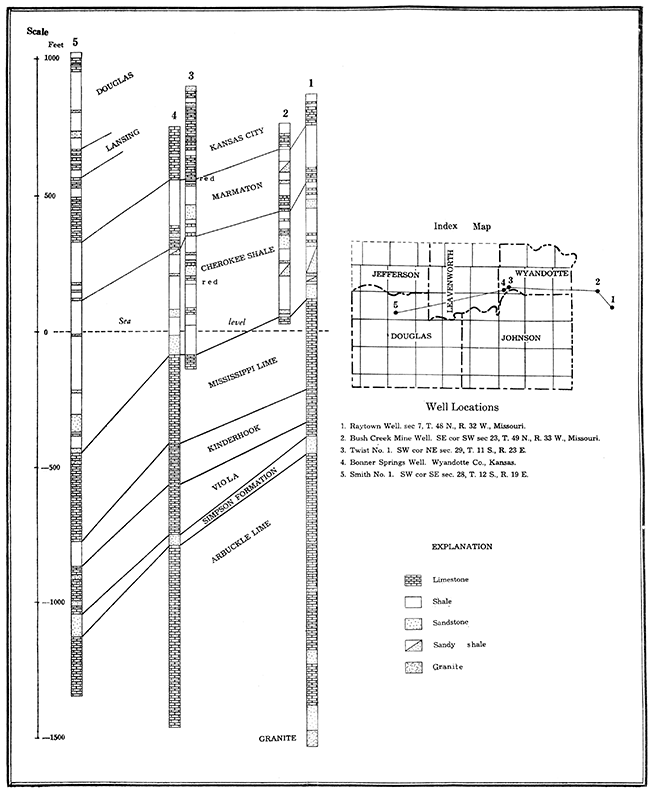
The rock formations exposed in Wyandotte County belong to the Pennsylvania system and include most of the Kansas City, Lansing, and basal Douglas groups. These are overlain by deposits of Pleistocene and Recent age.
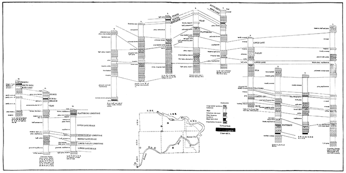
Pennsylvanian formations, so classed because of their equivalence to certain rocks in Pennsylvania, are represented in Wyandotte County by the Kansas City and Lansing groups of alternating shale and limestone beds, and a soft, buff sandstone in the western part of the county which lies at the base of the Douglas group. Some of the individual formations are neither as uniform nor as persistent as is generally the case in the Pennsylvanian rocks in eastern Kansas; however, others are quite regular and serve admirably as key beds for mapping structure. The best key beds are the Cement City, Raytown, and Iola limestones. The upper surface of the Iola limestone can be used as a key horizon over a wide area, but care must be taken to distinguish the formation from the overlying Farley limestone. Some variation occurs in the lower part of the Iola and the base is generally poorly exposed. Below the Cement City a degree of uncertainty is introduced by variations in the Drum limestone. West and southwest of Bonner Springs all but about a foot of the upper Lane shale has been removed above the Iola, so structures drawn on the Plattsburg or Stanton limestones in this area are apt to be unreliable. At and southwest of Bonner Springs the thick Farley limestone practically rests on the Iola, although at no place in the county is the lower Lane shale entirely absent. The lower Lane shale elsewhere ranges from a few feet to as much as 40 feet in the northern part of the county. It is 14 feet thick at Camp Naish of the Boy Scouts of America about a mile east of Bonner Springs. Here occurs the best single exposure of the complete Lansing group to be found in the county. In northern and eastern Wyandotte County the Farley limestone consists of two limestones and an included shale. Elsewhere the Farley is a single limestone bed. The other units are generally uniform.
The lowermost Pennsylvanian group, the Cherokee, which consists of thick sandstone and shale beds, is of great economic importance. All of the natural gas found in Wyandotte County and much of it found elsewhere in eastern Kansas comes from the Cherokee. Traces of oil have also been encountered in this group in Wyandotte County. The Cherokee shale averages about 350 feet in thickness, but varies considerably from place to place. It is overlain by a series of thick shales and intercalated limestones belonging to the Marmaton group. Thick sandstone lenses may occur locally near the top of the Marmaton. The thickness of the Marmaton group in northeastern Kansas is variable but averages about 225 feet.
Glacial gravels and till overlie the Pennsylvanian rocks at many places. No gravel deposit sufficiently large to be of commercial value has yet been found. The widespread covering of loess, a fine, buff, silty soil, is of considerable economic importance. Loess occurs in greatest quantity along the bluffs of Kansas and Missouri Rivers, and thins toward the uplands. It is very fertile and well suited for certain types of agriculture, chiefly fruit orchards and truck farming. The deposits of Recent age consist of fertile alluvium on the flood plains of all the major streams, colluvial soil and rock debris at the foot of hill slopes, and the residual soil which covers the upland away from the river valleys.
| Geologic formations exposed in Wyandotte County | ||||||
|---|---|---|---|---|---|---|
| Quaternary rocks | ||||||
| Recent series | ||||||
| Alluvium | 0-120 | |||||
| Colluvium | 0-10 | |||||
| Residual soil | 0-2 | |||||
| Pleistocene series | ||||||
| Loess | 0-50 | |||||
| Kansan drift | 0-8 | |||||
| Pennsylvanian rocks | ||||||
| Missouri series | ||||||
| Douglas group | ||||||
| Weston (?) shale | 0-50+ | |||||
| Disconformity | ||||||
| Lansing group | ||||||
| Stanton limestone | ||||||
| South Bend limestone | 5 ± | |||||
| Rock Lake shale | 7 ± | |||||
| Stoner limestone | 12 | |||||
| Eudora shale | 6 | |||||
| Meadow limestone | 5 1/2 | |||||
| Vilas shale | 24 | |||||
| Plattsburg limestone | ||||||
| Upper Plattsburg limestone | 10 | |||||
| Lower Plattsburg limestone | 2-4 | |||||
| Local disconformity | ||||||
| Lane shale | ||||||
| Upper Lane shale | 1-25 | |||||
| Farley limestone | ||||||
| Upper Farley limestone | 5-10 | |||||
| Middle Farley (shale) | 5-0 | |||||
| Lower Farley limestone | 28-10 | |||||
| Lower Lane shale | 1-40 | |||||
| Kansas City group | ||||||
| Iola limestone | 28 | |||||
| Chanute shale | ||||||
| Upper Chanute shale | 25 | |||||
| Raytown limestone | ||||||
| Upper Raytown limestone | 6 | |||||
| Middle Raytown (shale) | 5 | |||||
| Lower Raytown limestone | 1 | |||||
| Middle Chanute shale | 12 | |||||
| Cement City limestone | 10 | |||||
| Lower Chanute shale | 5 | |||||
| Drum limestone | 14 | |||||
| Cherryvale shale | 14 | |||||
| Winterset limestone | 50 | |||||
| Galesburg shale | 8 | |||||
| Bethany Falls limestone | 24 | |||||
The natural resources of Wyandotte County are soil, loess, limestone, shale, sand, gravel, coal, and natural gas.
The soils of Wyandotte County are in part the result of the disintegration of the underlying shales and limestones, and in part formed through deposition by water, wind, and ice. The loess is principally confined to the eastern part of the county and to the hills bordering the river valleys and is well adapted to fruit growing and, truck farming. The alluvium of the valleys of the major streams is fertile, although the Missouri river plain is generally swampy and poorly drained. The flood plain of Kansas river supports a large truck farming industry. The soil covering the uplands in the western part of the county is sandy and is utilized for general farming and dairying.
Limestone suitable for nearly all of the many uses to which the rock may be put is abundant in Wyandotte County. There are several quarries producing crushed stone for the large demand of greater Kansas City. The Iola limestone is most used for this purpose because of its thickness and its accessibility with small overburden in the eastern part of the county. The Bethany Falls limestone is also used for crushed stone, but it crops out in only a small area south of Kansas river. The Farley limestone is being quarried near Wolcott and is used in the river improvement work conducted by the Federal Government. The great amount of chert (flint) in the Winterset and in most places in the Drum limestone makes those two ledges especially good for the production of rubble. Very little limestone is used for dimension blocks. The Meadow limestone which crops out in the western part of the county contains durable building stone. This is true generally of the thin limestone just below the Raytown, and the blocky layers at the base of the Plattsburg limestone. Limestone and shale for making Portland cement are abundant. Cement is being manufactured at Bonner Springs in one of the large plants of the state.
Many of the shales are suitable for making clay products, although Wyandotte County has no such industry. There is a large plant producing clay products in Kansas City, Missouri, and the same raw materials are available in Wyandotte County. Probably the best shale for this purpose occurs in the upper Chanute shale.
Five companies are taking sand from Kansas river and shipping it in railway cars and trucks. There are two other sources of sand in the county. One is the higher sand of glacial origin which would perhaps fulfill many of the purposes for which the river sand is used. This supply is exhaustible, however, whereas the sand removed from the river is being constantly replaced. The other source is the massive, incoherent sandstone at the base of the Weston shale which covers most of the western part of the county This sand is fine and not adapted for many uses.
The glacial gravels consist mostly of very hard and durable rock fragments. Excellent road gravel could be obtained by screening. No large single deposit of the material is known, but much of the overburden in the limestone quarries along Missouri river and in the eastern part of the county consists of this type of gravel.
The small amount of coal cropping out in Wyandotte County has no commercial value. The most important coal-bearing rocks of the state, which lie in the Cherokee shale, are deeply buried in this area. The 2-foot coal bed mined at the State Prison at Lansing lies at a depth there of 709 feet, but should be about 150 feet nearer the surface at Kansas City. At Raytown, Missouri, a diamond drill hole revealed several beds of coal at depths of 294 to 525 feet. The bed mined at Leavenworth is believed to be 454 feet below the surface at Raytown and is 1 foot, 8 inches thick. The same bed was formerly mined at Randolph in Clay county, Missouri, and south of Kansas City at Brush Creek, Missouri.
No oil in sufficient quantity to be commercially important has so far been discovered. It. is possible that deeper drilling on some of the large untested structures may lead to the discovery of minor oil pools.
Natural gas. All of the gas production in Wyandotte County comes from shallow wells which range in depth from about 350 to 800 feet. A favorable show of gas has been encountered at 1050 feet in the northwest corner of the county, but this is below the horizon that produces most of the gas in the area. No gas or oil have been obtained in commercial amounts from any of the few wells that have penetrated below the top of the Mississippian limestone. The data are as yet insufficient to permit the making of structural maps of the deeper formations, and it is quite possible that none of the deeper wells were drilled on favorable subsurface structures. Probably few of the local structures observed at the surface in eastern Kansas extend below the base of the Pennsylvanian. On the other hand the depth to which a surface structure may extend can only be ascertained by deep drilling. The possibilities of deep production of oil or gas have by no means been exhausted until considerable, well planned deep drilling has been done.
It has long been known that gas occurs at a moderate depth at various place in Wyandotte County. Many wells have been producing a small amount of gas for a period of many years. The gas from such long-lived wells in eastern Kansas is generally called shale gas, because it issues slowly from compact shale instead of the usual pervious sand.
Recent drilling of larger wells in the Fairfax district in northern Kansas City, Kansas, has stimulated interest in the gas resources of the county. These wells are producing from a sand horizon at a depth of about 375 feet. The sand bodies are apparently flat lenses instead of the large channel deposits found in Miami and Anderson counties, and occur in various parts of the county at approximately a single stratigraphic horizon. Owing to the general northwestward dip of the rocks in the county this gas horizon is considerably deeper toward the western and northern parts of the county, reaching a depth of about 550 to 600 feet north of Bonner Springs.
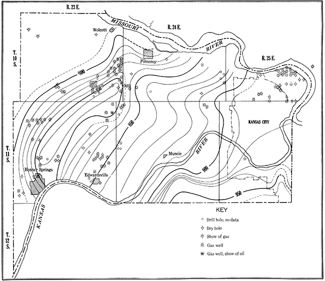
Two principal gas producing areas occur in Wyandotte County. The newest and the one having the largest wells is the Fairfax field. The other field covers a considerable part of Townships 10 and 11 S., Range 23 E. and might be termed the Bonner Springs field. The accumulation of gas at the Fairfax field may be controlled by structure, but if this is true the structure is quite local. Variable porosity of the reservoir rock is probably of much greater importance in controlling the accumulation of gas in this field. The Fairfax wells are closely spaced and the amount of production may vary surprisingly between two adjoining wells. The initial daily production in the larger wells ranges well above two million cubic feet, but wells producing a little less than a million cubic feet are common. Gas accumulation in the Bonner Springs field has been due to the presence of a favorable anticline. However, the wells are widely scattered and have in general been poorly located in regard to this structure. Wells producing up to a million cubic feet of gas are not uncommon, but the average is more nearly 250 thousand cubic feet. Some of the smaller wells have been producing gas consistently for ten years or more. Probably larger wells will be brought in higher on the structure.
The accompanying reconnaissance structure map shows the distribution of the larger structural features in Wyandotte County. It was made by readings of elevation with the Paulin surveying altimeter and checked by independent readings. Careful stratigraphic work preceding the determinations of elevations at selected points made possible a reduction of the altimeter readings to a structural datum. Detailed structural mapping will doubtless show minor folds that are of value in searching for natural gas.
The principal structure is the Maywood anticline, which extends from Bonner Springs to the southeast corner of T. 10 S., R. 23 E. Shallow wells on structures such as this should be drilled on the crest rather than on the flanks. A small amount of oil was obtained in a well at the County Farm which is higher on the anticline than most of the gas wells.
Deep wells drilled on the anticline should be located slightly below the crest on the southeast limb in order to compensate for the regional dip. An anticline trending west of north occurs in the vicinity of Wolcott. Local flexures on it may produce small closures favorable to gas accumulation. An unusually abrupt nose occurs opposite Muncie on the south side of Kansas river. This structure represents possibly the termination of a closed anticline to the south. A small anticline that may become a producer occurs in the southeast corner of the county. The extent and true character of this structure will be known only after detailed structural mapping is done. In the adjoining part of Johnson county there are oil wells that may be located on the southern continuation of this fold.
Kansas Geological Survey, Mineral Resources of Wyandotte County
Placed on web Feb. 4, 2016; originally issued in May 18, 1931.
Comments to webadmin@kgs.ku.edu
The URL for this page is http://www.kgs.ku.edu/Publications/Bulletins/Circ4/index.html