![]()
Prev Page--Introduction || Next Page--Hydrologic setting
Geologic Setting
Permian Rocks
Rocks of Permian age that crop out in the area of investigation include the Nolans Limestone of the upper part of the Chase Group and the Wellington Formation and Ninnescah Shale of the Sumner Group (pl. 1 and fig. 3).
The Nolans Limestone is the lowermost unit exposed in the study area (pl. 1). These rocks, which average about 35 feet in thickness, crop out in extreme southeastern Sumner County and western Cowley County.
Figure 3. Part of gamma ray-neutron log of well in 16-4W-22DAB showing stratigraphic relationship of bedrock units discussed in this report.
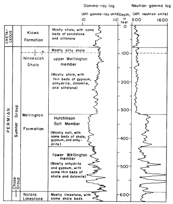
Wellington Formation
The Wellington Formation forms the bedrock unit underlying the major part of the unconsolidated deposits in the study area (pl. 1). The Wellington, which dips gently westward and southwestward, can be divided into three distinct units in the subsurface of central Kansas. The lower Wellington member, the "anhydrite beds" of Ver Wiebe (1937), consists of gray shale and some dolomite alternating with many thin anhydrite and gypsum beds (Lee, 1956). Thickness of the lower Wellington ranges from 150 feet in Saline County to almost 250 feet in Sumner County, and averages about 200 feet.
The middle unit of the Wellington Formation is the Hutchinson Salt Member. In Reno County, where no dissolution has occurred, the unit averages 300 feet in thickness and consists of salt interbedded with minor amounts of shale, gypsum, and anhydrite.
The upper Wellington member consists mainly of gray shale with minor amounts of gypsum, anhydrite, dolomite, and siltstone. Thickness of the Wellington averages 250 feet, but the contact with the overlying Ninnescah Shale is indefinite because of lithologic similarities between the two units (Leonard and Kleinschmidt, 1976).
Ninnescah Shale
The Ninnescah Shale conformably overlies the Wellington Formation and crops out in the extreme western part of the area of investigation. The Ninnescah also forms the bedrock surface under the unconsolidated deposits in Tps. 18, 19, and 21 through 23 S., R. 4 W. and Tps. 24 through 26 S., Rs. 3 and 4 W. The Ninnescah consists of alternating beds of brownish-red silty shale and siltstone interbedded with some thin beds of gypsum. A few thin beds of gray-green silty shale occur in the lower part (Lane and Miner, 1965).
Cretaceous Rocks
The Kiowa Formation of Cretaceous age unconformably overlies the Ninnescah Shale or the Wellington Formation along parts of the Smoky Hill River valley in northern McPherson and Saline Counties. The Kiowa Formation consists of light- to dark-gray and black clay and shale with thick lenticular beds of iron-stained quartzitic sandstone. Owing to their greater resistance to erosion, the sandstone beds are the most conspicuous feature of the Kiowa because these beds cap all the high hills bordering the Smoky Hill River valley (Latta, 1949).
Undifferentiated Tertiary and Quaternary Deposits
Unconsolidated deposits of Tertiary and Quaternary age overlie much of the bedrock units throughout the area of investigation (pl. 1). Undifferentiated Pliocene deposits of Tertiary age occupy a small area in northern McPherson County. Undifferentiated Pleistocene deposits of Quaternary age, which contain the principal aquifers, underlie the major valleys of the area. The aquifers include the "Equus beds" in McPherson, Reno, Harvey, and Sedgwick Counties (Stramel, 1956); the Arkansas River alluvium in Reno, Sedgwick, and Sumner Counties; the Ninnescah River alluvium in Sedgwick and Sumner Counties; and the the Smoky Hill River alluvium in Saline County. The deposits consist of sand and gravel interfingered with lenses of silt and clay.
Subsidence in the underlying Wellington Formation, as a result of salt dissolution and the subsequent subsidence and erosion of overlying beds, has influenced the depositional patterns of Pleistocene streams in the study area. The McPherson channel, which trends southward from near Lindsborg, was a major drainageway in the area prior to being filled with Pleistocene deposits. This channel contains nearly 250 feet of saturated deposits. The Arkansas River channel contains nearly 300 feet of saturated deposits.
The reader is referred to Williams and Lohman (1949) and Lane and Miller (1965) for a more complete discussion of the Pleistocene drainage and depositional history of the area.
Prev Page--Introduction || Next Page--Hydrologic setting
Kansas Geological Survey, Geology
Placed on web Jan. 2006; originally published 1981.
Comments to webadmin@kgs.ku.edu
The URL for this page is http://www.kgs.ku.edu/Publications/Bulletins/CQS9/03_geol.html