![]()
Prev Page--Contents || Next Page--Geologic setting
Introduction
Degradation in the chemical quality of freshwater in streams and aquifers has adversely affected the suitability of water for public use in several areas of central Kansas. This degradation commonly occurs as a result of the natural discharge of saline water from the Wellington Formation of Permian age. [Note: The classification and nomenclature of the rock units used in this report are those of the Kansas Geological Survey and differ somewhat from those of the U.S. Geological Survey.] The contaminating water is generated as a result of differential solution of salt by circulating freshwater. The dissolution occurs along the eastern edge of the Hutchinson Salt Member and associated gypsum units of the Wellington where they are in proximity to freshwater systems. Dissolution of the salt has resulted in the formation of a discontinuous zone of solution cavities and collapsed beds. This zone, which extends southward from Salina toward the Oklahoma State line, is termed the Wellington aquifer.
The hydrologic conditions that control the flow from saltwater systems into freshwater systems are not fully understood, and the severity of degradation has not been accurately documented.
In this report, water is classified generally in terms of dissolved-solids concentrations in milligrams per liter (mg/L). Freshwater is defined as having less than 1,000 mg/L dissolved solids, saline water is 1,000 to 35,000 mg/L, and brine is more than 35,000 mg/L.
Purpose and Scope
Saltwater inflow from the Wellington aquifer has resulted in degradation of freshwater systems in several areas of central Kansas. Contamination of the freshwater systems has deleteriously affected their use for industrial, municipal, irrigation, and domestic purposes.
The purpose of this study, made in cooperation with the Kansas Geological Survey, is: (1) To describe the general geohydrologic relationships between saltwater from the Wellington aquifer and freshwater in the major unconsolidated aquifers in central Kansas, (2) to determine the location, extent, and severity of the naturally occurring saline-water inflow into the major stream-aquifer systems, and (3) to provide an assessment of possibilities for alleviation or control of the pollution in each of the stream-aquifer systems.
The geohydrologic relationships between saltwater and freshwater aquifers are described by structure, thickness, and potentiometric-surface maps and geohydrologic cross sections. A steady-state digital model of ground-water flow was constructed as an aid in understanding the hydraulic characteristics of the Wellington aquifer and determining if the observed, or conceptual, potentiometric surface was mathematically feasible. Seepage and salinity measurements were made on several streams to delineate areas of saline-water intrusion. Methods available to alleviate degradation of the freshwater aquifers are discussed.
Location and Extent of Area
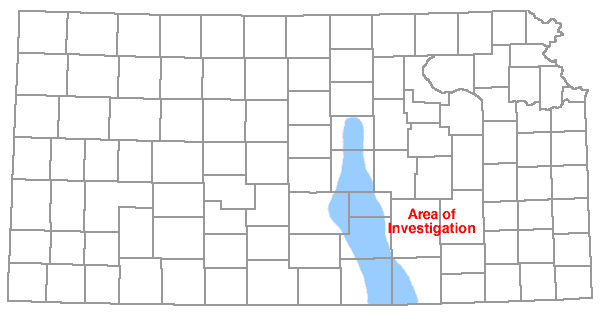
The area of investigation comprises about 1,500 square miles and includes parts of Saline, McPherson, Reno, Harvey, Sedgwick, Sumner, and Cowley Counties, Kansas (fig. 1). Freshwater supplies produced in this area serve approximately 400,000 people.
Figure 1. Map of Kansas showing area of investigation.
Previous Investigations
Many reports have been published on the geology and hydrology of the area. The reader is referred to Lane and Miller (1965) for a complete listing of these works. Comprehensive reports on the geohydrology of the area that were most referred to by the author are mentioned here. Kulstad (1959) reported on the Hutchinson Salt Member of the Wellington Formation. Williams and Lohman (1949) published a comprehensive report on the hydrogeology of McPherson County and parts of Reno, Harvey, and Sedgwick Counties. Latta (1949) reported on the ground-water conditions in Saline County. Stramel (1956, 1967) published progress reports on the ground-water hydrology of the "Equus beds" area. Petri and others(1964) reported on the water resources of the Wichita area. Walters (1961) discussed the geology and ground-water resources of Sumner County. Lane and Miller (1965) discussed the geohydrology of Sedgwick County, and Leonard and Kleinschmidt (1976) reported on saline water in the Little Arkansas River basin.
Methods of Investigation
Electrical logs were used to construct maps of the top and thickness of the eastern part of the Hutchinson Salt Member of the Wellington Formation. Twenty-four observation wells, screened in the Wellington aquifer, were installed between Solomon and Geuda Springs. An aquifer test of the Wellington aquifer was conducted in April 1977 using the facilities of Home Petroleum Company, Conway, Kansas.
Water samples were collected from selected wells for complete chemical analyses, including determination of bromide, iodide, and lithium concentrations. A solid salt sample was collected from the Interspace Mine, Hutchinson, Kansas. Prior to analysis, this sample was dissolved with deionized water until the chloride concentration was comparable with the average chloride concentration of water samples collected from the Wellington aquifer.
In an attempt to locate areas and estimate quantities of saline-water inflow to streams, seepage and salinity measurements were made on the Ninnescah River and Slate and Salt Creeks in Sumner County. Water samples collected during this investigation were analyzed by the Kansas Department of Health and Environment or the U.S. Geological Survey.
A water-table map of the freshwater deposits (pl. 1) and a potentiometric-surface map of the Wellington aquifer (pl. 4) were prepared. Control for these maps was based on water-level measurements of approximately 250 wells made in April 1977. The Kansas Water Resources Board, the City of Wichita, and the U.S. Geological Survey cooperated in this effort.
A steady-state digital model of ground-water flow was constructed as an aid in understanding the hydrologic system of the Wellington aquifer. Data for the model consisted of water-level measurements and aquifer-test data.
Acknowledgments
Appreciation is expressed to the many individuals and companies who supplied information incorporated in this investigation. Special acknowledgment is made to John Mooney, Home Petroleum Company, Conway, Kansas, for making his facility available for a 24-hour aquifer test of the Wellington aquifer and for allowing installation of a permanent recorder on one of the company observation wells. The author is also grateful to Messrs. William Biegler and Ralph O. Connor, Kansas Department of Health and Environment, for providing data and for their suggestions. Mr. Michael Withrow, City of Wichita Water Department, was most helpful in providing necessary data and in assisting with the mass water-level measurement in April 1977.
Well-Numbering System
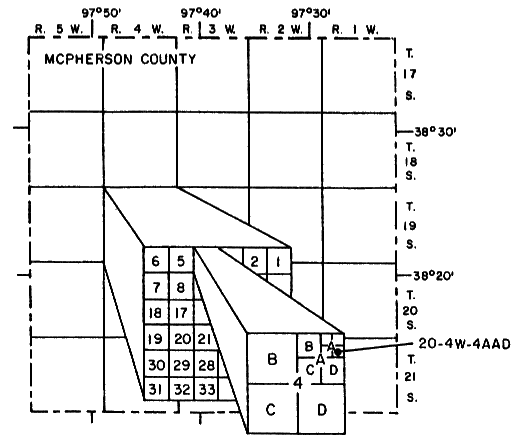
The system of numbering wells and test holes in this report is based on the U.S. Bureau of Land Management's system of land subdivision. The first number indicates the township; the second indicates the range west or east of the sixth principal meridian; and the third indicates the section in which the well is located. The first letter denotes the quarter section or 160-acre tract; the second, the quarter-quarter section or 40-acre tract; and the third, the quarter-quarter-quarter section or 10-acre tract. The letters are designated A, B, C, and D in a counterclockwise direction beginning in the northeast quarter of the section. Where there is more than one well in a 10-acre tract, consecutive numbers are added in the order in which the wells are inventoried. For example, 20-4W-4AAD indicates a well in the southeast quarter of the northeast quarter of the northeast quarter of sec. 4, T. 20 S., R. 4 W. (fig. 2).
Figure 2. System of numbering wells and test holes in Kansas.
Conversion to Metric Units
For those readers who may prefer to use metric units rather than the inch-pound units,the conversion factors for International System (SI) of Units and abbreviations for terms used in this report are given below:
| Inch-pound units | Multiply by | SI units |
|---|---|---|
| Foot (ft) | 0.3048 | Meter (m) |
| Mile (mi) | 1.609 | Kilometer (km) |
| Square mile (mi2) | 2.590 | Square kilometer (km2) |
| Gallon per minute (gal/min) | 6.309x10⁻² | Liter per second (L/s) |
| Cubic foot per second (ft2/s) | 0.0283 | Cubic meter per second (m3/s) |
| Barrel (bbl) | 0.1590 | Cubic meter (m3) |
Prev Page--Contents || Next Page--Geologic setting
Kansas Geological Survey, Geology
Placed on web Jan. 2006; originally published 1981.
Comments to webadmin@kgs.ku.edu
The URL for this page is http://www.kgs.ku.edu/Publications/Bulletins/CQS9/02_intro.html