![]()
Prev Page--Geomorphology || Next Page--Ground Water
Geology in Relation to Ground Water
Paleozoic Rocks
General
The total thickness of Paleozoic rocks increases from about 2,600 feet near Lawrence to more than 3,000 feet west of Topeka. Rocks from all the systems of the Paleozoic except the Permian System are present, but only the Ordovician, Mississippian, and Pennsylvanian Systems are represented by more than 200 feet of sediments (Jewett, 1949a). Of the entire Paleozoic sequence only the upper rocks of Pennsylvanian age crop out in northeastern Kansas. Although all the rocks are not conformable, the entire sequence dips gently westward.
Three groups of Pennsylvanian rocks were mapped--Douglas, Shawnee, and Wabaunsee. The formations included within the groups that were mapped and their general water-bearing characteristics are given in Table 3. Most of the information concerning the Pennsylvanian rocks is generalized from Moore (1940, 1949).
A detailed study of ground water in rocks of Pennsylvanian age was not attempted. Generally wells obtain water from solution openings in limestone and from sandstone. Except in weathered zones, shale and siltstone yield virtually no water to wells.
Table 3--Generalized section of the geologic formations of the Kansas River Valley between Lawrence and Topeka, Kansas. *Pennsylvanian System generalized from Moore (1940, 1949).
| System | Series | Subdivisions | Thickness, feet |
Character | Water Supply | |
|---|---|---|---|---|---|---|
| Quaternary | Pleistocene | Recent and Wisconsinian alluvium | 40-90 | Clay, silt, sand, and gravel, well sorted in major valleys; generally fine textured near the top and grading downward into coarse sand and gravel. | Alluvium of major valleys yield,, large amounts of water to industrial, irrigation, municipal, domestic, and stock wells. Quality of water is generally good. | |
| Sanborn formation | Peoria silt member | 0-9 | Silt, well sorted, light yellow-gray to ash-gray. Thin mantle on uplands south of Kansas River. | Above water table, yields no water to wells. | ||
| Loveland silt member | 0-2 | Silt, well sorted, reddish-tan to reddish-brown. Locally present under Peoria silt on uplands. | Above water table, yields no water to wells. | |||
| Crete and Loveland members undifferentiated | 0-90 | Sand, sandy silt, fine gravel in lower portion (Crete) grading upward into reddish-brown to reddish-tan silt (Loveland). | Locally basal portion yields moderate amounts of water to wells. | |||
| Meade formation | Sappa member | 20-50 | Silt and sandy silt, reddish-tan to reddish-brown. | Generally above water table, yields no water to wells. | ||
| Grand Island member | 5-40 | Pebbles, cobbles, and boulders at the base, locally cemented with calcite to form conglomerate; many lenses of sand. | Often above water table, yields abundant amount of water when in zone of saturation. | |||
| Kansas till | 0-40 | Till, largely clay and silt with scattered pebbles, cobbles, and boulders. Yellowish-brown to reddish-brown at the surface; is blue-gray when not weathered. Contains interstratified sand and gravel in thick sections. | Generally a poor source for water. | |||
| Atchison formation | 0-30 | Fine sand and coarse tan silt, well sorted; 6-15 feet of gravel at the base. | Too limited in extent to be of importance as an aquifer. | |||
| Undifferentiated pre-Kansan gravel | 0-8 | Chert-limestone gravel, well sorted. | Too limited in extent to be of importance as an aquifer. | |||
| Pennsylvanian* | Virgilian | Wakarusa Group Nemaha subgroup |
Wakarusa ls. | 3-15 | Dark-bluish hard limestone that becomes brown when weathered. | Locally supplies water to upland domestic and stock wells. |
| Soldier Creek sh. | 6-10 | Bluish-gray clayey to sandy shale. | Yields little water. | |||
| Burlingame ls. | 4-10 | Brown, fine-grained, hard, thick-bedded, appearing mottled and brecciated in some exposures. | Yields small to moderate amounts of water to domestic and stock wells. | |||
| Wakarusa Group Sacfox subgroup |
Silver Lake sh. | 15-45 | Gray and yellow clay shale, variably associated with platy, impure limestone, sandy shale, or sandstone. | Sandstone within the shale formation locally yields moderate amounts of water to wells. | ||
| Rulo limestone | 1-4 | Bluish-gray, locally mottled with light-brown when weathered; single massive bed with vertical jointing | ||||
| Cedar Vale sh. | 16-60 | Bluish to yellowish-brown clayey and sandy shale and sandstone with coal bed near the top. | Small to moderate ground water yields from sandy portions. | |||
| Happy Hollow ls. | 1-8 | Single, persistent massive bed, pinkish-brown and characterized by large fusulines. | ||||
| White Cloud sh. | 30-80 | Bluish-gray to yellowish-brown clayey and sandy shale with local sandstone and conglomerate fill channels. | Yields moderate amounts of water in sandy portions. | |||
| Howard limestone | 8-20 | Gray-blue, thin, dense, sandy limestones, alternating with bluish-gray to yellowish-brown sandy shale. | Solution openings in the lime-stones yield some water to wells. | |||
| Severy shale | 70-80 | Yellowish-brown and bluish-gray shale and a minor amount of platy to massive sandstone | Sandstone yields a small quantity of water to wells. | |||
| Shawnee group | Topeka ls. | 35-45 | Alternating light-gray to bluish-gray massive, fine-grained, dense limestones and bluish-gray to black sandy shales. | Yields moderate amounts of water to domestic and stock wells. | ||
| Calhoun shale | 40-50 | Clayey and sandy dark-gray to tan shale containing plant fossils; minor limestone and coal beds. | Local massive sandstone yields moderate amounts of water. | |||
| Deer Creek ls. | 25-45 | Alternating light-gray to bluish-gray, fine-grained limestones sometimes characterized by wavy bedding and by presence of chert nodules and gray or yellow fissile shale. | Yields moderate quantities of water of generally good quality to domestic and stock wells; is source for a number of springs. | |||
| Tecumseh shale | 45-65 | Clayey and sandy shale, unfossiliferous, having a more or less discontinuous limestone in upper part. | Small amounts of water derived from sandstone in upper part of formation. | |||
| Lecompton ls. | 30-40 | Consists of 4 limestone members commonly bluish-gray, dense, and fossiliferous and 3 shale members with included sandstone lenses. | Moderate amounts of water derived from solution openings in limestone. | |||
| Kanwaka sh. | 40-60 | Yellowish-brown to bluish-gray sandy shale containing numerous plant fossils and an intervening bluish-gray, massive, vertical-jointed fossil-bearing limestone. | Moderate amounts of water derived from sandstone channel fills. | |||
| Oread ls. | 40-50 | Four limestone members ranging from light-brownish- gray to bluish-gray, massive and dense to thin, wavy bedding and generally fossiliferous, and 3 shale members brown to black, calcareous to sandy, fossiliferous. | Moderate amounts of water derived from Toronto and Plattsmouth limestone members to domestic and stock wells. | |||
| Douglas group | Lawrence sh. | 250 | Blue-gray and yellowish shale, tan-colored sandstone, and a minor amount of coal, limestone, and conglomerate. | Moderate supplies of water of varying quality derived from sandstone member to domestic and stock wells. | ||
| Stranger formation | 60-90 | Light-tan to yellowish-gray sandstone and shale and a minor amount of limestone, coal, and conglomerate with marine and nonmarine fossils. | Large quantities of water of generally good quality derived from the lowest member of this formation, the Tonganoxie sandstone. Water supplies municipal, domestic, and stock wells. | |||
The water table in the rocks of Pennsylvanian age is in general a subdued reflection of the topography and is commonly from 10 to 30 feet below the surface (Pl. 2); however, due to the importance of stratigraphic control, the water table is not everywhere continuous. Depth to the water table is not always an indication of the total depth needed for a well, particularly in shaly rock, because it is often necessary to drill wells much deeper in order to encounter rocks of higher permeability.
The depth to brackish water in the Paleozoic rocks is highly variable. In most cases drilling for fresh water to depths greater than 300 feet would seem inadvisable, and in many wells the depth to brackish water is reported to be less than 150 feet.
Douglas Group
The Douglas group consists of massive or cross-bedded sandstone, siltstone with numerous carbonaceous layers, and thinly bedded shale. Two rather thin persistent limestone beds and several thin and discontinuous coal beds are minor constituents of the group.
Sandstones in the Douglas group generally yield adequate amounts of potable water near the outcrop areas, but the quality of water becomes progressively worse down dip. Wells which supply water for cooling, air conditioning, domestic, and stock uses have been drilled into these sandstones. Water from most of these wells is brackish (Lohman, 1941) and much of the water is of such poor quality that it is unfit for human consumption. Generally water of the best quality is pumped from wells which penetrate the Tonganoxie sandstone which is the lowest sandstone member of the Douglas group (Lins, 1950).
Shawnee Group
The Shawnee group is differentiated from the other units mapped by its thick persistent limestone members and by its well-defined megacyclothems. Where the rocks crop out they are characterized physiographically by prominent eastward-facing limestone escarpments and by a more rugged topography south of Kansas River. Limestone, sandstone, and shale beds of the upper portion of the Shawnee group are shown in Plate 5A.
Plate 5--A, Topeka limestone capping sandstone and minor amounts of shale and siltstone in the Calhoun shale, NE SW sec. 15, T. 11 S., R. 16 E. B, Large conglomeratic quartzite boulder transported by the Kansan ice, Cen. sec. 19, T. 10 S., R. 16 E. C, Weathered till 4 miles north of Perry, Jefferson County.
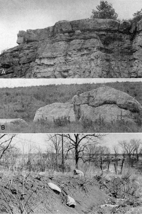
Limestone and sandstone are both important water-bearing rocks within the Shawnee group. During periods of normal or greater than normal rainfall, wells in these rocks yield adequate supplies for domestic and stock needs; however, many wells failed to yield sufficient water during the exceptionally dry spring of 1950. A number of small springs issue from the various limestone members in the group. Most of the springs cease to flow during periods of little rainfall. The largest spring measured had a discharge of 50 gallons per minute during the summer of 1950, but was reported to have gone dry for brief periods during the severe droughts between 1930 and 1940.
Wabaunsee Group
Sacfox subgroup
Shale, sandstone, and siltstone are the most common rocks in the Sacfox subgroup. Three relatively thin limestone formations with two coal seams are also within the subgroup. The water-bearing capacity of the rocks in this subgroup is generally poor, although, when present, sandstone yields moderate amounts of water to wells.
Nemaha subgroup
Only the lower 50 feet of this subgroup occurs in the area mapped. The lower part of this subgroup is dominated by two prominent limestone formations. Where sufficient solution openings are present the limestone beds are good sources of ground water.
Quaternary Deposits
Pre-Kansan gravel
Three deposits of gravel composed predominantly of chert were found along the north bluff of the Kansas River Valley. All deposits are overlain by Kansas till or outwash but contain less than 1 percent erratic material and more than 50 percent chert in the 4 to 8 mm size. This gravel lithology is considerably different than that of known glacial outwash (Davis, 1951), so it is judged that these gravels are either pre-Kansan gravels that have derived a small number of erratics from Nebraskan glacial outwash or are remotely pro-glacial gravels of early Kansan age. The distribution of these gravels is too limited to be of importance as a source of ground water.
Atchison formation
Sand and gravel overlain by Kansas till and underlain by Pennsylvanian shale occur in at least three exposures. The best exposure found is in an old gravel pit in the SE NW sec. 16, T. 11 S., R. 16 E. Here till overlies 15 feet of well-sorted yellow-gray fine sandy silt which in turn overlies a moderately well-sorted limestone-chert gravel. The gravel contains about 60 percent well-rounded but slightly etched limestone pebbles, 20 to 30 percent chert, 5 to 10 percent shale and siltstone, and 2 percent granite and quartzite. Locally the gravel is cemented by calcite to form a very hard conglomerate, and even in the seemingly unconsolidated portions, the gravel is of'll,en partially cemented together. Interstitial space in the gravel is filled with medium to coarse quartz sand. With the exception of the upper part of the till, the gravel, sand, and till show only the slightest evidence of post-depositional weathering.
The age of these deposits is judged to be Kansan as their conformable relation to the overlying till suggests that they were deposited in front of the advancing ice and later overridden by the ice. This conclusion is strengthened by the persistent, but not abundant, fragments of northern erratics in the gravel. The high percentage of limestone precludes the possibility of the gravel having been deposited by a major pre-glacial stream since the limestone would be highly etched and secondary to chert in abundance (Davis, 1951). The Kansan pro-glacial outwash has been named the Atchison formation from exposures in the vicinity of Atchison, Kansas (Moore and others, 1951, p. 15).
Pro-glacial outwash seems to be too limited in distribution to be important as a source of ground water in the area studied. It is possible that deposits similar to the one described are present under parts of the till-mantled uplands, and if present in a saturated zone, would afford an excellent source of water.
Kansas till
Uplands north of Kansas River are mantled by glacial till which ranges in thickness from a thin veneer of clayey soil to more than 40 feet of typical till. Owing to post-depositional erosion, the till is thickest and most persistent on crests of hills. In many places north of Kansas River it is thick enough and continuous enough to modify the usual bedrock topography. In an early soil survey the presence of glacial till was clearly recognized in Shawnee County and was classified as Shelby loam (Byers and Throckmorton, 1913). Although 16 percent of the county was mapped as Shelby loam, only a small fraction was found to be south of Kansas River. It was also noted that till was thickest and most common directly north of Kansas River and that the till thinned gradually to the north (Byers and Throckmorton, 1913, p. 19). These observations strongly suggest that the Kansan ice sheet was stabilized for a considerable time directly north of Kansas River and that any advance across the present river valley by the ice was of relatively short duration.
The till is characterized at the surface by a clayey red soil tho-roughly oxidized and leached and containing scattered cobbles and pebbles of quartz, chert, granite, and various metamorphic rocks. Satisfactory exposures of thick sections of till were very uncommon, but generalizations can be made from the few exposures found in this area and in areas to the north. Four zones which are caused by different degrees of weathering can be differentiated in the till; these are shown below.
Zones in the Kansas till
- Red clay zone. Highly leached and oxidized zone, red in color and containing exclusively siliceous pebbles in the coarser fraction; commonly modified by colluvial action.
- Mottled gray clay zone. Leached and oxidized, mottled gray and light brown in color, and contains almost entirely highly siliceous pebbles, limonitic shale fragments, and various metamorphic rocks; locally jointed.
- Oxidized and unleached till. Yellow brown to green brown in color with abundant limestone, chert, shale, and granitic pebbles; ferromagnesian minerals in rock are altered near the rock surfaces and limestone is slightly etched; till is commonly jointed.
- Unoxidized and unleached till. Dark blue-gray in color and has essentially the same pebble content as C; very hard and impervious as compared to other zones; may contain interstratified sand and gravel in thicker portions (Frye and Walters, 1950, p. 151).
Previous workers have, emphasized the abundance of pink quartzite in the till; however, it was found by cobble and pebble studies that pink quartzite is only a minor constituent of the original till and that surface concentrations of quartzite are an indication of prolonged and selective weathering (Davis, 1951). Even in highly weathered till only the boulder size is more than 50 percent pink quartzite. A fine-grained femic quartzite is particularly abundant in the smaller sizes as are also chert, quartz, weathered granite, and various unclassified metamorphics.
Kansas till is very high in clay and silt content. No complete size analysis of the till was made, but a separation of fragments larger than 1 mm was made and it was found that this coarse fraction was only about 5 percent of the total sample.
Boulders exceeding 5 feet in mean diameter are very uncommon in the till. The largest boulder observed is a few miles north of the mapped area in the Cen. sec. 19, T. 10 S., R. 16 E. This boulder is pink conglomeratic quartzite and is split into two pieces, the larger being 23 by 11 by 8 feet and the smaller being 18 by 7 by 2 feet. The measurements are only of that part exposed above the ground (Pl. 5B). This large boulder must have been transported a minimum of 200 miles, since the nearest outcrop of pink quartzite is in northeastern Iowa. Smaller and more typical glacial boulders are shown in Plate 5C.
The till transmits water very slowly due to its high clay content, which makes the till a poor source for ground water and also adversely affects the recharge. Thus if till is very thick in any locality, shallow wells are usually unsuccessful. All dug wells investigated in till-mantled areas were found to penetrate the till and to draw water from underlying Pennsylvanian rocks, or from the till-bedrock contact zone. Many small seeps were seen along till-bedrock contacts for as long as a month after heavy rains, but no perennial springs were found to derive water from till.
Meade formation
Deposits which are classed as Meade formation occur along both the north and south bluffs of Kansas River Valley. The upper surface of these deposits forms a high terrace which is mapped as the Menoken terrace (Pl. 1), and which is discontinuously mantled with loess, eolian sand, and sand derived from slope wash. These thin surficial deposits range in age from Illinoian to Recent.
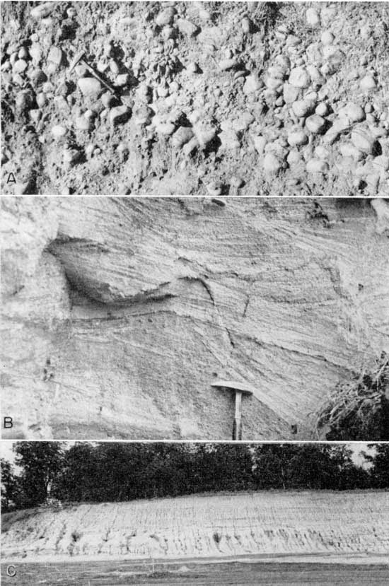
The Meade formation in Kansas River Valley has three well-defined zones which are usually, but not always, present. The lowest zone is a coarse gravel with abundant cobbles and boulders which in many localities attains a thickness of at least 30 feet (Pl. 6A). The percentage of rock types in the 4 to 8 mm size range was found to be about 60 percent limestone, 20 percent chert, 8 percent sandstone and shale, 5 percent granite, 3 percent metamorphic rocks, 2 percent quartz, 1 percent limonitic concretions, and 1 percent dark igneous rocks. In the thicker gravel deposits rocks are mostly unaltered except near the surface where only highly siliceous rocks are left in a red clayey soil. Commonly the gravel is roughly cross-bedded and is interstratified with coarse sand. Three facts indicate that the lowest zone is closely associated with the Kansan glacier. (1) Till was found to interfinger with the gravels northeast of Kiro (cen. SW sec. 9, T. 11 S., R. 15 E.). (2) Boulders with a mean diameter of about 500 mm are not unusual in the gravels, whereas the normal gradient of Kansas River is sufficient only to transport cobbles of about 60 mm mean diameter (Wyman, 1935, p. 230). This extreme difference in size is best explained by abnormal gradients which would exist along an ice front. (3) The gravels have a lithology almost identical to gravel in the glacial till but quite different from the present material being transported by Kansas River and the older pre-Kansan chert gravel (Davis, 1951). Overlying the lowest zone is a somewhat discontinuous zone of sand and silt containing a few lenses of gravel and granules (Pl. 6B). The top zone, which is the most distinctive of the three zones, is a reddish sandy silt which is 30 to 40 feet thick (Pl. 5C). The silt is massive and tends to weather with columnar jointing; however, a very weak stratification can sometimes be seen. The entire thickness is leached and unfossiliferous. Numerous pebbles scattered through the silt and a large percentage of sand in the silt preclude the possibility of the material being a loess. As noted by Hoover (1936), the surface of the deposits is roughly parallel with the present river profile,, so lacustrine deposition of the silts also seems unlikely. It is believed that the silt represents the final stage of afluviation initiated by the coarser glacial outwash.
Plate 6--Meade formation in Douglas County, Kansas. A, Coarse Grand Island gravel at the base of the Meade formation, SW SW sec. 9, T. 12 S., R. 20 E. B, Cross-bedded sands in the central part of the Meade formation, SE sec. 14, T. 12 S., R. 19 E. C, Sand overlain by Sappa silt of the Meade formation, cen. sec. 14, T. 12 S., R. 19 E.
In some localities a clear differentiation can be made between the lower Atchison formation, representing pro-glacial outwash, and the overlying Grand Island member of the Meade formation, representing outwash from the retreating Kansan glacier. However, in many localities where this distinction cannot be made, outwash sand and gravel is, for convenience of mapping and description, considered as belonging to the Grand Island member of the Meade formation. The overlying sandy silt is classed as the Sappa member of the Meade formation.
The bedrock base of the Meade formation in this area is at least 10 feet above the present flood plain of Kansas River. This is evidenced by four test holes in the Topeka area, three test holes near Lawrence, and eight road-cut exposures between Lawrence and Kiro.
In general the Meade formation in this area is not a good aquifer, because ground water is easily drained from the lower part of the formation by deeply incised streams and by Kansas River Valley. Many people having houses in the area underlain by Meade formation use either cisterns or municipal water. Several houses near the bluff facing the valley are supplied by wells in the valley alluvium and water is brought to the houses by pressure systems. Northwest o'l Lawrence some wells drilled through the Meade formation draw water from the underlying Pennsylvanian sandstones.
Undifferentiated middle Pleistocene alluvial fill and colluvium
In tributary valleys remnants of glacial outwash, a younger terrace, colluvium, and slope wash are all present and can generally be differentiated. However, in many places these were not mapped separately because individual units were often too small to be clearly shown on a map. The greater part of these undifferentiated deposits is a red clayey silt which is almost free of pebbles but locally contains sand and gravel in the basal part. Most clayey silt deposits at heads of tributary valleys (swales of Hoover, 1936, p. 144) seem to be slope wash or colluvium that has stabilized and is being dissected by gullying at the present time. Much of the red clayey silt is found in terrace deposits along the creeks. The terraces are somewhat dissected and stand from 15 to 25 feet above the flood plain; they are probably equivalent in age to the Buck Creek terrace.
Owing to low permeability, dissection, and small thicknesses, these deposits are a poor source of ground water. No wells were found to obtain water from these undifferentiated deposits.
Sanborn formation
Loess and alluvial deposits which are classed as belonging to the Sanborn formation are widespread in the area mapped. The loess, the greater part of which is considered to be the Peoria silt member of the Sanborn formation, mantles most of the upland areas south of Kansas River but is generally too thin to map. The small areas that were mapped as loess (Pl. 1) are all south of Kansas River and all have maximum loess thicknesses of more than 5 feet. The greatest thickness of loess found in the area was in the northern part of Tecumseh in the SE NE sec. 36, T. 11 S., R. 16 E. At this locality there is exposed in a railroad cut 9.8 feet of Peoria silt overlying 10 feet of Loveland silt which has a well-developed Sangamon soil profile on top and grades downward into at least 12 feet of Crete gravel. The Loveland silt of this area is in part, if not entirely, an alluvial deposit, the upper surface corresponding to the Buck Creek terrace in both elevation and lithology. Elsewhere Peoria silt overlies residual bedrock soil and till and less commonly overlies a thin layer of eolian Loveland silt.
Alluvial deposits of the Sanborn formation have a maximum known thickness of 90 feet at the Buck Creek School in sec. 27, T. 11 S., R. 19 E. Here rotary drilling penetrated 90 feet of silt and fine silty sand which had only slight textural changes in the entire thickness. This silt is classed as the Loveland silt member of the Sanborn formation.
All loess found was above the water table and is important to considerations of ground-water supply only as it affects recharge. The alluvial deposits are generally of fine texture and constitute only a minor source of ground water. Local Crete gravels,, if present in a saturated zone, may serve as a satisfactory source for moderate supplies of ground water. Only one well which obtained water from these deposits was inventoried.
Wisconsinan and Recent alluvium
All river and major stream valleys in the area have deep alluvial fills which reach a maximum thickness of almost 90 feet in the Kansas River Valley. In general, the deeper alluvial fills grade upward from a coarse cobble fill in the deepest portion to a fine sand or silt at the surface. Sediments encountered while test drilling in Kansas River Valley indicate that the first 40 feet is similar to sediments transported by Kansas River at the present time while below this depth boulders are encountered which are much larger than the cobbles recovered from surface samples in the present river channel. The largest fragment of rock recovered by us weighed 77 grams; the largest fragments recovered by the U.S. Engineers from 34 samples of bed load did not exceed 64 mm in diameter (Wyman, 1935, pp. 229-230). The lower cobbles may be related to deposition by abnormal depths of scour during flood stages, or may be related to an earlier deposition at a time when the river flowed at a lower level.
The upper 30 feet of sediment grades laterally from a medium to fine sand near the river to a silty clay under the parts of the Newman terrace which are the greatest distance from the river. Much of the finer material near the bluffs is a "backswamp" deposit, the surface requiring artificial draining to allow cultivation. Even with this surface drainage many hundred acres of land were inundated during the summer months in 1950 and 1951. Adjacent to the present river channel is a highly scarred flood plain surface over which the river has meandered in the last few hundred years. This section has coarse silt and fine sand at the surface which grades downward into fine to coarse gravel. On this flood plain the fine silts and clays are confined to channel scar fillings or "clay plugs." No test holes were drilled in the channel scars, but three auger holes were dug more than 8 feet into clay with no sign of coarser sediments.
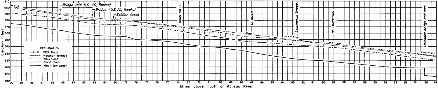
The age of the alluvial fill ranges from Wisconsinan to Recent since these deposits truncate Illinoian terrace fills and alluviation on the flood plain and the Newman terrace has been observed within historical times. The three largest floods on record occurred in 1844, 1903, and 1951. The 1951 flood was the most severe of the three; all these floods deposited some material on the Newman terrace. The 1903 flood covered minor parts of the terrace (Fig. 4), and the 1844 and 1951 floods covered all but a few of the high areas along the natural levee.
Figure 4--Profile of Kansas River from Lawrence to Topeka showing the relationship of the 1903 flood to Newman terrace and the flood plain. (River elevations from U. S. Army Engineers, 1944.) A larger version of this figure is available.
A two-day reconnaissance was made two weeks after the 1951 flood to attempt to determine the amount of sediment deposited by the flood. Since much of the flood plain was inaccessible during this reconnaissance, only an approximation of the deposition on the Newman terrace could be made. A total of 32 thicknesses were measured at selected intervals between Lawrence and Kiro. The thicknesses were obtained by averaging several measurements in a single locality. Areas near fence lines, ditches, houses, and trees were avoided. The thickness of sediment deposited on the Newman terrace was found to range from a minimum of less than 1 mm to a maximum of about 14 mm; the average was about 5 mm. The sediment deposited was a calcareous tan to light-brown silt which graded from a coarse silt at the natural levee to a silty clay in the "backswamp" areas. The silt was leached in areas in which the sediment was less than 2 mm thick and in which water had stood with a large amount of organic debris in it. Scouring by the flood water was evident only at the margins of the terrace and is considered to be negligible on the terrace.
In contrast to the thin silty clay on the Newman terrace, the flood plain has deposits of coarse silt which in many places near buildings and fences exceed 3 feet in thickness. Deposition on the flood plain seems to, be controlled principally by the strength of the currents flowing through an area during a flood and by the amount of vegetation next to the ground which is effective in arresting the movement of the bed-load sediment. Large areas of scour were apparent along old meander scars and flood-overflow channels.
Valley alluvial deposits are the major water-bearing sediments in the entire region. In general, the larger the valley and the deeper the fill, the more satisfactory the water supply will be. The Kansas River Valley is by far the most favorable source for large quantities of water. The coarse gravels have a very high permeability and are excellent aquifers. Water temperature is uniformly from 56 to 58 degrees F. except near Kansas River where infiltration of river water causes a seasonal fluctuation of from 5 to 10 degrees F. The water is somewhat harder than that obtained from Kansas River, but has the advantages of constant temperature and little or no turbidity.
Recent sand dunes
Two small sand-dune areas were found on the flood plain near Grantville. Several dunes are active at the present time and are adversely affecting crops at a number of points within the dune tract. The sand was seen moving in large quantities during the dust storms in the spring of 1950. Channels more than 10 feet deep were cut in the dunes during the 1951 flood.
The dune sand does not seem to be more than 20 feet thick. None of the wells inventoried obtained water from these sands; however, it is well sorted and permeable and is probably of local importance as an excellent recharge area.
Prev Page--Geomorphology || Next Page--Ground Water
Kansas Geological Survey, Geology
Placed on web April 10, 2012; originally published June 1, 1952.
Comments to webadmin@kgs.ku.edu
The URL for this page is http://www.kgs.ku.edu/Publications/Bulletins/96_5/05_geol.html