Kansas Geological Survey, Bulletin 90, Part 7, originally published in 1951
Originally published in 1951 as Kansas Geological Survey Bulletin 90, Part 7.
This report describes the lithology of 29 gravel samples and relates the lithology to the origin of the gravels. The major geologic sources for gravel in northeastern Kansas are local sedimentary rocks, the Ogallala formation of western Kansas and western Nebraska, and local glacial drift. Pre-Nebraskan gravels consist entirely of local material derived from sedimentary rocks. Kansan gravels are dominantly limestone with mixed glacial erratics which were deposited along the ice front of the Kansan glacier. Post-Kansan gravels are dominated by arkosic material from the Ogallala formation.
Most gravel utilized commercially is either glacial outwash or Recent arkosic river gravel. Both types of gravel seem satisfactory for ordinary uses; however, the higher limestone content of the outwash makes it more desirable for concrete aggregate.
Present stream gravel in northeastern Kansas is derived principally from three geologic sources: (1) local shales, siltstones, sandstones, and limestones of late Paleozoic age; (2) Pliocene arkosic gravels of the Ogallala formation in western Kansas and Nebraska; and (3) glacial till and outwash of early Pleistocene age. The influence of these three sources on gravel lithology varied greatly during Pleistocene time, producing a number of lithologically distinct types of gravel deposits.
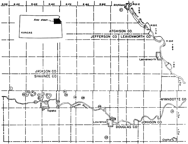
The economic and geologic significance of these gravel types and the techniques used in studying the gravel are discussed in this paper. Sand and gravel production is an important mineral industry in Kansas and the specifications that must be met for various uses are constantly calling for more precise data on the lithologic character of these naturally occurring materials. The geographic distribution of the samples studied is given in Figure 1.
Fig. 1--Index map showing location of samples studied.
In late Tertiary time a low but important divide existed along the Flint Hills in eastern Kansas. Major eastward-flowing rivers in western Kansas turned south before reaching the Flint Hills and streams in eastern Kansas had their headwaters in the Flint Hills region, draining to the east (Lohman and Frye, 1940). In eastern Kansas, gravels deposited by these early streams, always found in high topographic positions, are common in areas not mantled with later glacial till and outwash.
The earliest deposits of known Pleistocene age in northeastern Kansas are those deposits associated with Nebraskan glaciation. Studies of surface exposures (Frye and Leonard, 1949) and of samples from subsurface drilling (Frye and Walters, 1950) have shown that the Nebraskan glacier entered the northeastern corner of Kansas and may have advanced as far as southern Nemaha County and northern Jackson County. The probable margin of glaciation is marked by a deep east-west trending valley which is filled with later Kansas till. This valley may have been large enough to carry all the glacial outwash, thus preventing any appreciable amount from entering existing drainage basins to the south.
The second and also the last glacier to enter the State was the Kansan glacier which overrode remnants of Nebraska till and advanced to a point well beyond the earlier glacial margin. The maximum advance of the Kansan glacier was to a line a few miles south of Kansas River (Schoewe, 1930); however, the ice front was probably stabilized for the longest period just north of Kansas River. Glacial outwash and till filled many existing stream valleys. Alonog the ice-marginal Kansas River there was deposited outwash with a maximum thickness of more than 50 feet, having interstratified till at the bottom, and grading into 30 to 50 feet of fine sand and sandy silt at the top. Remnants of this fill form a prominent high terrace along Kansas River.
During Kansan time the Flint Hills divide was breached by glacial melt water, and the present course of the Kansas River was established. This river basin enlargement caused many important changes in western Kansas drainage patterns and also is responsible for the most striking change in gravel lithology found in the Kansas River Valley in eastern Kansas.
Following the deposition of late Kansan and Yarmouthian sediments, erosion again became more active, and streams cut deeply into bedrock. In the Kansas River Valley bedrock was cut more than 50 feet deeper than the former bedrock level under Kansan sediments. After this cutting valleys were again alluviated in late Illinoian time. The terrace representing this cycle of deposition is not well preserved along Kansas River. However, along many of its smaller tributaries terraces of equivalent age can be traced for considerable distances. In the vicinity of Kansas River the surface of this terrace is about 50 feet lower than the surface of the Kansan age terrace. Loveland loess was also deposited during this alluvial cycle, but the loess is generally less than 10 feet thick in northeastern Kansas and is absent over large areas.
The last major alluvial cycle was initiated early in Wisconsinan time. In the Kansas River Valley bedrock was cut slightly lower than the bedrock under the terraces of Illinoian age. After this cutting the valley was again alluviated to a level about 30 feet lower than the Illinoian terrace.
During the time of the last major cycle of erosion and alluviation a great amount of loess was deposited. Along the bluffs of Missouri River in Doniphan County Wisconsinan loess has a maximum thickness of more than 100 feet. The loess thins rapidly away from Missouri River and, except in the eastern part, the thickness rarely exceeds 10 feet in the area shown in Figure 1 (Frye and others, 1949).
A recent entrenchment of 10 to 15 feet along Kansas River and its tributaries in northeastern Kansas has left a low but distinct terrace flanking the modern flood plain.
The lithologic characteristics of 29 samples are described in this report. Samples were obtained by exposing a fresh surface of the outcrop and collecting a channel sample weighing from 5 to 10 pounds. In all 18 channel samples were collected. Of the remaining 11 samples, 5 were from rotary drill holes, 4 were collected -from the surface of sand bars in river and stream channels, and 2 were from auger holes. A comparison of seven samples of Kansas River gravel (Table 1) indicates that sampling techniques have introduced little or no systematic error.
Table 1--Lithologic uniformity of Kansas River pebbles (4-8 mm size)
| Sample No. | Arithmetic mean |
Standard deviation |
|||||||
|---|---|---|---|---|---|---|---|---|---|
| 20 | 21 | 22 | 23 | 24 | 25 | 26 | |||
| Granitic group | 63.9 | 58.7 | 59.8 | 61.7 | 53.0 | 59.9 | 58.0 | 59.2 | 4.9 |
| Misc. metamorphics | 3.8 | 1.0 | 2.8 | 5.5 | 3.8 | 2.4 | 4.0 | 3.3 | 1.1 |
| Chert group | 10.2 | 10.6 | 10.2 | 7.4 | 11.4 | 12.1 | 9.8 | 10.2 | 1.6 |
| Limestone | 2.0 | 9.5 | 4.3 | 1.0 | 1.8 | 2.0 | 5.0 | 3.7 | 2.7 |
| Shale-sandstone group | 3.9 | 3.3 | 4.5 | 1.8 | 5.5 | 6.0 | 6.3 | 4.5 | 1.4 |
Sediment Particles smaller than 1/8 mm in diameter were washed from the sample and the coarser material dried at room temperature. The coarser material was then separated into standard Udden grades (1/8-1/4 mm, 1/4-1/2 mm, 1/2-1 mm, etc.). Lithology determinations of several grade sizes were made for nine samples. All other samples were analyzed only in the 4-8 mm grade size. This size was most convenient owing to the fineness of much of the gravel. For ease of handling and identification the 8-16 mm size would have been more convenient.
Fragments larger than 2 mm were identified megascopically, and those smaller were identified.with the aid of a binocular microscope. Identifications were carried as far as was practical, both megascopically and with the binocular microscope. Acid was used freely on fresh surfaces to determine carbonate pebbles and other pebbles commonly were broken to help in identification. Eight thin sections were made to better identify selected rock types. Lithologic types were later placed in eight general groups to facilitate comparison and analysis of separate gravel deposits.
The following are the lithologic groups used in this report:
A comparison of percentage by weight, number, and volume (Table 2) showed that percentage by weight and by volume approximated each other very closely, while percentage by number varied as much as 3 percent from the other two. This variation is largely a function of irregularities in shape. Since greater speed and accuracy can be maintained by determining percentage by weight in sizes between 2 and 8 mm, this method was used in all the reported analyses except where otherwise noted. All samples were weighed to 1/100 gram, which gives accuracy within one-tenth of 1 percent for diameters as small as 1 mm. Sufficient number of counts of different pebble sizes were made to be able to approximate the average weight of individual pebbles and thus estimate the number of pebbles in each sample. Percentages are given to one-tenth of 1 percent to show variations in minor constituents. However, this apparent accuracy is not statistically significant and does not imply that the smaller values are expected to have a great degree of uniformity from one sample to the next.
Table 2--Comparison of lithologic percentcage by volume, weight, and number of sample 2.
| Lithologic group | 8-16 mm (429 pebbles) |
4-8 mm (389 pebbles) |
|||||
|---|---|---|---|---|---|---|---|
| Limestone | Chert | Quartz | Sandstone | Siltstone | Shale | Limestone | |
| Number percentage | 61.6 | 27.3 | 1.9 | 2.1 | 1.4 | 1.2 | 64.3 |
| Volume percentage | 59.5 | 30.9 | 1.1 | 1.6 | 1.6 | 0.9 | 61.1 |
| Weight percentage | 60.5 | 30.7 | 1.1 | 1.3 | 1.5 | 0.8 | 67.6 |
| Number of pebbles | 264 | 117 | 8 | 9 | 6 | 5 | 250 |
The nature of surface detritus, which is generally weathered and is often in a soil zone, is far more important in relation to source material than the character of the rock as it would be mapped geologically. Thus a small area mapped as a silty shale may yield detritus to a stream which in the coarser fraction is 80 percent limonitic concretions, or a larger area which is mapped as alternating sandstone, shale, and cherty limestone may yield an almost pure chert gravel to the master stream of the area.
The greatest modification by stream transportation seems to be the percentage reduction of the shale-sandstone group. This reduction is due, for the most part, to attrition during transportation. The effect of attrition on the limestone and granitic groups is probably great although this was not verified in the present study. Work by Plumley (1948) has demonstrated that the feldspar and limestone of the Black Hills, South Dakota, are abraded in about equal amounts during stream transportation. Most of the limestone pebbles in present-day streams in northeastern Kansas have highly etched surfaces which seem to be the result of solution. The major part of the solution is believed to be accomplished prior to stream transportation, as etching seems to be as far advanced on limestone from ephemeral streams as from Kansas River.
The first post-depositional modification is generally the leaching of limestone fragments followed by the more gradual decomposition of the feldspars and the ferromagnesian minerals. The modification of gravel lithology in tills is particularly striking and has been extensively studied in Iowa (Kay and Apfel, 1929).
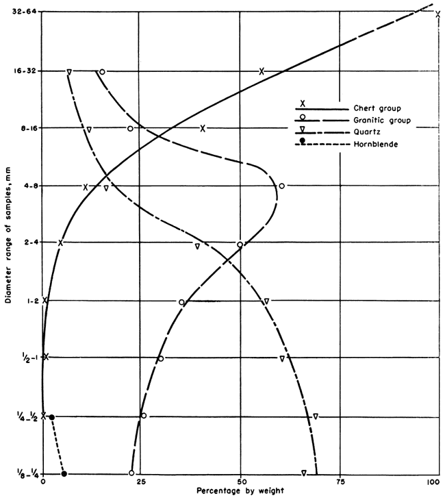
All gravels investigated have some systematic variation of lithology with size. The most uniform variations were found to exist in Kansas River sand and pebbles. Through the entire size range of the sediments there are at least three and probably four dominating mineral or rock constituents which appear in different grade sizes (Fig. 2). The dominant constituents in the smallest sizes are probably the clay minerals. The dominant constituent in the smallest size investigated is quartz. Among the particles between 2 and 8 mm in diameter the dominant rock type is granitic. The chert group is dominant in sizes larger than 8 mm.
Fig. 2--Variation of lithology with particle size of Kansas River sediment.
Local ephemeral streams seem to have a shale-sandstone maximum between 4 and 8 mm and a limestone maximum in fragments larger than 32 mm.
Glacial till and glacial outwash are dominated by limestone in all sizes between 2 and 500 mm. The chert percentage tends to rise from about 8 percent in the 1 to 2 mm size fraction to about 30 percent in the 16 to 32 mm size fraction. The quartz percentage tends to decrease from about 5 percent in the 1 to 2 mm size fraction to none among the particles larger than 32 mm in diameter. Pink quartzite seems to be more numerous in the boulder size than in the pebble size.
In view of these variations a rigid size control is essential to eliminate large errors introduced by approximating pebble diameters. It is also necessary to have substantial amounts of the pebbles in the original sample both smaller and larger than the size range chosen to be investigated. This largely eliminates the chance of a screened sample having particles whose mean diameter would be near to either the upper or lower limit of the screens used. In the case of Kansas River sediments this unbalanced size distribution in one grade size could cause as much as a 35 percent error. Another partial solution to this problem would also be to greatly restrict the diameter range of the fragments investigated.
Variations in the shape and specific gravity of individual fragments are factors causing selective transportation of gravel. On the samples studied the effect of selective transportation was not apparent, and the fact that glacial till and glacial outwash have very similar lithologies indicates that selective transportation is of only minor importance in determining the lithology of glacial outwash.
The term "chert gravel" has been associated so often with Tertiary gravel in Kansas that the two terms have become almost synonymous. However, it should be kept in mind that lithology alone does not imply deposition during any specific geologic time, except in places where glaciation across former divides or changes in drainage lines have introduced into the source area of a stream distinctive lithologic types that were formerly absent. Chert gravels are being deposited at the present time in streams south of the drift border and east of the Flint Hills, and the coarser fraction of the gravel transported by Kansas River at the present time is essentially a chert gravel (Table 3, samples 20, 21, and 22). Chert has been available from the outcrops of Permian rocks in eastern Kansas continuously since Tertiary time and therefore, it is not the chert but other rock types that may or may not be intermixed with it that are of significance in geologic dating. The lithologies of three samples of chert gravel were determined (Table 3, samples 1, 2, and 3). Sample 1 is a leached chert gravel from a high topographic position north of the Kansas River Valley. The very small percentage of northern erratics may represent contamination from the overlying till by burrowing animals. The high topographic position suggests that the gravel is late Tertiary in age and corresponds to the "higher chert gravels" of Todd (1918). Sample 2 was obtained from the locality described by Todd (1920) just north of the City of Atchison in the bluff of the Missouri River Valley. The gravel from near Atchison is overlain by the Atchison formation (a pro-glacial silt and fine sand of Kansan age) which in turn is overlain by Kansas till and Wisconsinan loess. The gravel is also near the Nebraska till border. The absence of erratics in the gravel indicates that the deposit is pre-Nebraskan in age. The gravel is unleached and is probably representative of chert gravels which have remained virtually unaltered since deposition. Sample 3 is a leached chert gravel which occurs 50 feet above the present flood plain of Kansas River. The gravel is overlain by Kansas till. The absence of glacial erratics in the gravel indicates pre-Kansan deposition.
Table 3--Gravel lithology of samples
| Sample no. |
Location | Type of sample |
Formation | Size, mm |
Approx. no. pebbles** |
Lithologic group | |||||||
|---|---|---|---|---|---|---|---|---|---|---|---|---|---|
| Granitic | Dark igneous |
Misc. metamorphic |
Pink quartzite |
Quartz | Chert | Limestone | Shale- sandstone |
||||||
| 1 | NW NE 31-10-14E Shawnee Co. | channel | weathered Tertiary (?) chert gravel | 4-8 | 800 | 0.1 | 0.2 | 0.1 | 98.6 | 1.1 | |||
| 2 | SE cor. SW 30-5-21E Atchison Co. | channel | unleached Pre-Nebraskan chert gravel | 4-8 | 400 | 0.5 | 59.4 | 35.3 | 4.6 | ||||
| 2 | SE cor. SW 30-5-21E Atchison Co. | channel | unleached Pre-Nebraskan chert gravel | 8-16 | 200 | 52.6 | 47.3 | ||||||
| 2* | SE cor. SW 30-5-21E Atchison Co. | channel | unleached Pre-Nebraskan chert gravel | 16-32 | 75 | 57 | 40 | 3 | |||||
| 3 | NW NW 7-11-16E Shawnee Co. | channel | Weathered early Pleistocene chert gravel | 4-8 | 800 | 0.7 | 98.3 | 0.8 | |||||
| 3 | NW NW 7-11-16E Shawnee Co. | channel | Weathered early Pleistocene chert gravel | 8-16 | 230 | 99.3 | 0.6 | ||||||
| 3 | NW NW 7-11-16E Shawnee Co. | channel | Weathered early Pleistocene chert gravel | 16-32 | 37 | 100 | |||||||
| 4 | 10-6-20E Atchison Co. | channel | Kansas till unleached | 1-2 | 200 | 8.8 | 9.1 | 0.8 | 7.1 | 9.6 | 48.4 | 16.2 | |
| 4 | 10-6-20E Atchison Co. | channel | Kansas till unleached | 2-4 | 150 | 14.8 | 5.1 | 0.2 | 5.2 | 3.8 | 53.5 | 17.4 | |
| 4 | 10-6-20E Atchison Co. | channel | Kansas till unleached | 4-8 | 250 | 11.6 | 3.0 | 6.7 | 0.8 | 18.8 | 42.7 | 16.5 | |
| 4 | 10-6-20E Atchison Co. | channel | Kansas till unleached | 8-16 | 25 | 15.4 | 3.5 | 12.5 | 56.2 | 13.1 | |||
| 5 | SW 7-11-15E Shawnee Co. | channel | Kansas till unleached | 4-8 | 100 | 4.6 | 5.2 | 4.0 | 5.8 | 12.1 | 45.8 | 23.0 | |
| 6 | SW 9-11-15E Shawnee Co. | channel | Kansas till unleached | 4-8 | 100 | 2.9 | 1.8 | 5.3 | 50.2 | 39.3 | |||
| 7 | SE NW 16-11-16E Shawnee Co. | channel | Kansas till unleached | 4-8 | 100 | 1.0 | 0.5 | 0.5 | 5.1 | 57.6 | 35.3 | ||
| 8* | SE NW 16-11-16E Shawnee Co. | surface | Kansas till unleached | 256-512 | 51 | 9.8 | 90.2 | ||||||
| 9 | SW NW 4-11-17E Shawnee Co. | channel | Kansas till weathered | 1-2 | 224 | 28.3 | 11.0 | 1.3 | 36.3 | 3.8 | 8.0 | 11.3 | |
| 9 | SW NW 4-11-17E Shawnee Co. | channel | Kansas till weathered | 2-4 | 202 | 27.7 | 0.3 | 13.3 | 3.4 | 24.2 | 5.2 | 13.9 | 11.5 |
| 9 | SW NW 4-11-17E Shawnee Co. | channel | Kansas till weathered | 4-8 | 95 | 29.6 | 23.4 | 3.8 | 6.4 | 16.4 | 7.5 | 12.8 | |
| 9 | SW NW 4-11-17E Shawnee Co. | channel | Kansas till weathered | 8-16 | 9 | 11.7 | 19.7 | 19.5 | 28.5 | 13.1 | 7.3 | ||
| 10 | SW 7-11-15E Shawnee Co. | channel | Atchison formation | 4-8 | 250 | 0.5 | 0.9 | 1.0 | 50.5 | 44.0 | 2.3 | ||
| 10 | SW 7-11-15E Shawnee Co. | channel | Atchison formation | 8-16 | 100 | 0.3 | 0.8 | 63.4 | 33.2 | 2.3 | |||
| 10 | SW 7-11-15E Shawnee Co. | channel | Atchison formation | 16-32 | 11 | 92.2 | 7.9 | ||||||
| 11 | SE NW 16-11-16E Shawnee Co. | channel | Atchison formation | 2-4 | 601 | 1.8 | 2.4 | 0.2 | 7.7 | 12.6 | 59.5 | 15.6 | |
| 11 | SE NW 16-11-16E Shawnee Co. | channel | Atchison formation | 4-8 | 389 | 2.3 | 0.6 | 1.5 | 19.1 | 67.6 | 8.9 | ||
| 11 | SE NW 16-11-16E Shawnee Co. | channel | Atchison formation | 8-16 | 429 | 0.5 | 1.1 | 30.7 | 60.5 | 7.1 | |||
| 11 | SE NW 16-11-16E Shawnee Co. | channel | Atchison formation | 16-32 | 53 | 1.2 | 38.8 | 54.5 | 5.6 | ||||
| 11 | SE NW 16-11-16E Shawnee Co. | channel | Atchison formation | 32-64 | 4 | 45.2 | 54.6 | ||||||
| 12 | SW 9-11-15E Shawnee Co. | channel | Atchison formation | 4-8 | 300 | 0.1 | 0.6 | 36.4 | 54.5 | 8.8 | |||
| 13 | SE 26-13-19E Douglas Co. | channel | Grand Island mem., Meade fm. | 4-8 | 200 | 5.9 | 1.3 | 1.2 | 2.2 | 11.7 | 73.8 | 4.1 | |
| 14 | SW 9-11-15E Shawnee Co. | channel | Grand Island mem., Meade fm. | 4-8 | 276 | 4.1 | 0.6 | 8.4 | 0.5 | 3.7 | 23.3 | 48.5 | 9.6 |
| 15 | NE NW 11-12-23E Johnson Co. | channel | Grand Island mem., Meade fm. | 4-8 | 350 | 4.2 | 0.6 | 3.2 | 1.6 | 3.2 | 18.6 | 53.5 | 14.6 |
| 16 | Cen. 12-11-14E Shawnee Co. | channel | Meade fm. weathered | 4-8 | 150 | 24.1 | 10.7 | 5.0 | 12.5 | 14.5 | 6.7 | 26.6 | |
| 17 | SW 12-11-15E Shawnee Co. | channel | Meade fm. weathered | 4-8 | 350 | 39.2 | 2.5 | 6.3 | 1.8 | 9.3 | 4.5 | 1.3 | 35.0 |
| 18 | NE SE 13-11-17E Jefferson Co. | auger hole 9-10 ft. | Sanborn fm. Crete gravels | 4-8 | 137 | 64.7 | 2.7 | 13.9 | 3.4 | 15.5 | |||
| 19 | SE NE 36-11-16E Shawnee Co. | channel | Sanborn fm. Crete gravels | 4-8 | 500 | 81.9 | 1.7 | 6.1 | 6.0 | 0.6 | 3.9 | ||
| 20 | SE SW 13-11-15E Shawnee Co. | test hole 44-51 ft. | Kansas River alluvium | 1-2 | 300 | 31.7 | 1.3 | 0.1 | 64.5 | 1.8 | 0.2 | 0.4 | |
| 20 | SE SW 13-11-15E Shawnee Co. | test hole 44-51 ft. | Kansas River alluvium | 2-4 | 300 | 53.6 | 0.2 | 37.8 | 4.6 | 1.4 | 2.5 | ||
| 20 | SE SW 13-11-15E Shawnee Co. | test hole 44-51 ft. | Kansas River alluvium | 4-8 | 400 | 63.9 | 3.8 | 1.1 | 14.7 | 10.2 | 2.0 | 3.9 | |
| 20 | SE SW 13-11-15E Shawnee Co. | test hole 44-51 ft. | Kansas River alluvium | 8-16 | 100 | 58.0 | 1.4 | 0.5 | 9.9 | 17.1 | 8.8 | 4.0 | |
| 20 | SE SW 13-11-15E Shawnee Co. | test hole 44-51 ft. | Kansas River alluvium | 16-32 | 8 | 69.4 | 23.5 | 7.1 | |||||
| 21 | NE NE 27-11-15E Shawnee Co. | surface | Kansas River alluvium | 2-4 | 500 | 57.5 | 0.5 | 33.9 | 5.4 | 2.5 | |||
| 21 | NE NE 27-11-15E Shawnee Co. | surface | Kansas River alluvium | 4-8 | 350 | 58.7 | 1.0 | 16.8 | 10.6 | 9.5 | 3.3 | ||
| 21 | NE NE 27-11-15E Shawnee Co. | surface | Kansas River alluvium | 8-16 | 250 | 19.5 | 0.4 | 0.2 | 6.7 | 64.5 | 5.5 | 3.0 | |
| 21 | NE NE 27-11-15E Shawnee Co. | surface | Kansas River alluvium | 16-32 | 21 | 83.2 | 14.8 | 2.0 | |||||
| 21 | NE NE 27-11-15E Shawnee Co. | surface | Kansas River alluvium | 32-64 | 4 | 100.0 | |||||||
| 22* | NE SW 30-12-20E Douglas Co. | surface | Kansas River alluvium | 1/8-1/4 | 269 | 22.3 | 4.8‡ | 4.5† | 67.8 | 0.4 | 0.4 | ||
| 22* | NE SW 30-12-20E Douglas Co. | surface | Kansas River alluvium | 1/4-1/2 | 363 | 25.7 | 1.6‡ | 0.6¶ | 69.1 | 0.5 | 0.5 | 2.1 | |
| 22* | NE SW 30-12-20E Douglas Co. | surface | Kansas River alluvium | 1/2-1 | 318 | 30.2 | 0.6‡ | 60.7 | 1.2 | 0.9 | 6.2 | ||
| 22* | NE SW 30-12-20E Douglas Co. | surface | Kansas River alluvium | 1-2 | 650 | 35.4 | 1.0 | 0.5 | 56.4 | 0.9 | 0.9 | 4.8 | |
| 22* | NE SW 30-12-20E Douglas Co. | surface | Kansas River alluvium | 2-4 | 600 | 49.8 | 1.6 | 38.5 | 5.8 | 1.3 | 3.2 | ||
| 22* | NE SW 30-12-20E Douglas Co. | surface | Kansas River alluvium | 4-8 | 350 | 59.8 | 1.6 | 2.8 | 0.6 | 15.6 | 10.2 | 4.3 | 4.5 |
| 22* | NE SW 30-12-20E Douglas Co. | surface | Kansas River alluvium | 8-16 | 200 | 22.5 | 2.6 | 1.3 | 11.9 | 39.9 | 16.3 | 5.2 | |
| 22* | NE SW 30-12-20E Douglas Co. | surface | Kansas River alluvium | 16-32 | 37 | 14.3 | 4.7 | 2.7 | 6.4 | 54.9 | 12.5 | 4.5 | |
| 22* | NE SW 30-12-20E Douglas Co. | surface | Kansas River alluvium | 32-64 | 2 | 100.0 | |||||||
| 23 | NW SW 24-11-16E Jefferson Co. | auger hole 12-14 ft. | Kansas River alluvium | 4-8 | 150 | 61.7 | 5.5 | 22.6 | 7.4 | 1.0 | 1.8 | ||
| 24 | SW NW 24-11-15E Shawnee Co. | test hole 45-49 ft. | Kansas River alluvium | 4-8 | 250 | 53.0 | 3.8 | 0.4 | 24.2 | 11.4 | 1.8 | 5.5 | |
| 25 | SE NE 33-11-19E Jefferson Co. | test hole 33-60 ft. | Kansas River alluvium | 4-8 | 79 | 59.9 | 2.4 | 17.4 | 12.1 | 2.0 | 6.0 | ||
| 26 | NE SW 30-12-20E Douglas Co. | surface | Kansas River alluvium | 4-8 | 250 | 58.0 | 4.0 | 17.0 | 9.8 | 5.0 | 6.3 | ||
| 27 | SW NW 13-11-15E Shawnee Co. | test hole 81.5-87 ft. | bottom of Kansas River alluvium | 4-8 | 150 | 37.3 | 9.1 | 11.2 | 15.7 | 19.3 | 7.2 | ||
| 28 | NE NW 16-11-18E Jefferson Co. | test hole 46-69 ft. | Delaware River alluvium | 4-8 | 197 | 13.5 | 2.2 | 15.1 | 3.0 | 13.2 | 39.9 | 4.2 | 7.9 |
| 29 | SW SW 9-11-17E Jefferson Co. | surface | bed load ephemeral stream | 4-8 | 300 | 7.9 | 2.1 | 1.5 | 1.7 | 9.6 | 15.0 | 62.4 | |
| *Percentage by number. **Numbers given to nearest 50 are estimated; others are actual counts. ‡Hornblende. ¶Biotite and muscovite. †Unclassified. |
|||||||||||||
The coarser fraction was washed from four samples of unleached till and one sample of highly weathered till (Table 3, samples 4, 5, 6, 7, and 9). One count was made of boulders which had been washed by rain from unleached till in an old gravel pit (Table 3, sample 8). The lithology of rock fragments in the till varies considerably; however, all unleached samples retained the same general characteristics. Fragments of pebble size and larger constitute less than 5 percent of the volume of the samples. The limestone group is the dominant constituent in the sizes investigated and the shale-sandstone group is next in abundance in the smaller fractions. The total amount of locally derived rocks in the unleached till is in excess of 70 percent. A diagnostic feature of the 4 to 8 mm size pebbles in glacial till and outwash is that the granitic group and the combined dark igneous, miscellaneous metamorphics, and pink quartzite groups occur in roughly equal abundance (Fig. 3).
Fig. 3--Average gravel lithology in the 4-8 mm. fraction.
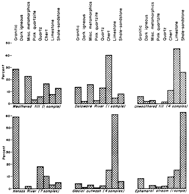
Glacial outwash gravel can be divided into two types, namely the pro-glacial outwash of Kansan age (Atchison formation) and the outwash derived from the retreating Kansan ice (Grand Island member of the Meade formation). The pro-glacial gravels contain from 0.1 percent to 3.0 percent erratics and 44 to 67 percent limestone in the 4 to 8 mm. size range. The Grand Island gravels have essentially the same gross characteristics of pebble and boulder lithology as has the till, the major difference being that in the Grand Island gravels the limestone pebbles are more rounded and the percentage of the shale-sandstone group is much lower (Fig. 3). A large amount of the shale-sandstone group which was originally a part of the glacial debris is judged to have been destroyed during transportation in the glacial melt waters. The lithology of the outwash, as is the case in the till, varies from place to place but retains the same gross characteristics.
Analyses were made of one sample from the Delaware River (which drains a till-mantled area), one sample from weathered till, and two samples from weathered Grand Island gravels (Table 3, samples 9, 16, 17, and 28). All samples clearly show concentration of the more resistant glacial detritus by selective weathering. Surface concentrations of pink quartzite boulders are common in northeastern Kansas and represent an advanced stage in the selective weathering of the parent material. Such concentrations do not represent the original lithology of the till nor do they represent the surface configuration at the time of deposition. The large amount of chert in the Delaware River gravel is judged to be caused by the influence of bedrock areas containing cherty limestones which are devoid of a till cover.
A gravel with the shale-sandstone group predominating in the 4 to 8 mm size was found in the only sample taken from an ephemeral stream. The high percentage of the shale-sandstone group reflects the local bedrock lithology and indicates a limited amount of transportation and attrition.
Two samples of Crete gravel and eight samples of Wisconsinan to Recent gravels were collected along Kansas River (Table 3, samples 18-27). The material smaller than 2 mm is dominated by the quartz group; between 2 and 8 mm it is dominated by the granitic group; and larger than 16 mm it is dominated by the chert group (Fig. 2). Limestone is a small percentage of the samples in all sizes investigated and most fragments are highly etched. Only one sample in Kansas River alluvium contains appreciable amounts of limestone. This sample was taken by rotary drilling from the deepest part of the alluvial fill. The greater limestone content evidently indicates a period of more vigorous erosion during which time more material was derived from unaltered bedrock than at the present time.
The largest percentage of granitic detritus found along Kansas River in pre-glacial gravel was 0.1 percent. Furthermore, only 2.3 percent granitic material was found in pro-glacial gravel, 4.6 percent in unleached till, and 5.9 percent in unleached glacial outwash. In contrast to these low percentages the granitic detritus carried by Kansas River since mid-Pleistocene time has been well above 50 percent of the 4 to 8 mm size range. The granite in post-Kansan deposits is also much coarser grained than the glacially associated granite. The more recent granitic gravel is judged to be derived largely from the Ogallala formation in western Kansas and western Nebraska while the earlier granitic detritus had its source in the glacially transported material from the north. It seems quite certain from this striking change in lithology that the pre-Kansan drainage system along the present course of Kansas River did not derive detritus from areas in which the Ogallala formation crops out.
Most chert gravel deposits in the area investigated are small and of minor economic importance. All the pits visited are inactive and some are in a state of disrepair. In the past, most of the gravel was used for road metal.
Only the larger rock fragments from the till (particularly pink quartzite) are used locally for ornamental purposes, building stone, riprap, and to fill erosional gullies. The quantity of rock used is quite small.
Some of the largest gravel pits are in deposits of glacial outwash. The gravel is high in limestone content and makes a good concrete aggregate if the shale-sandstone group is not too abundant. The gravel is also used extensively for road metal and less extensively for gravel packing water wells. Caution should be taken in using this gravel for packing wells as the high limestone content may cause cementation of the gravel after a period of time. Pit operation is sometimes hindered by large amounts of clay in the weathered portions, extensive cementation of the gravel, and excessively large boulders.
The largest quantity of sand produced in the Kansas River Valley region is recovered from the present channel of Kansas River. Grade sizes larger than 4 mm constitute only a small percentage of the total amount of sediment taken from the river. The gravel is used extensively for road metal and for concrete aggregate. The addition of limestone to the gravel often renders it more satisfactory for use as an aggregate.
The ratio of mineral fragments of feldspar to granitic rock fragments is shown in Figure 4. This ratio has economic importance since the feldspar content is undesirable in concrete aggregate and can only be separated from the aggregate when present as mineral fragments. Also, if separated from all other constituents, feldspar can be used in ceramic glazes and for other purposes. If an economically feasible method of separation could be developed, the upper limit of particle size to be used without the necessity of crushing the fragments would be about 1 mm.
Fig. 4--Variation of feldspar-granitic rock ratio with diameter of particle.
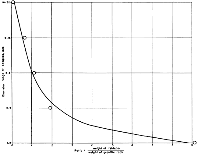
Gravel lithology in eastern Kansas varies systematically with the mean diameter of the gravel; therefore, studies of gravel lithology must utilize carefully sized material to obtain the most satisfactory results.
The four most significant gravel types studied were pre-glacial gravel, glacial outwash gravel of Kansan age, gravel from Kansas till, and gravel of Illinoian to Recent age which was transported by Kansas River. The unleached pre-glacial gravel is characterized by a predominance of chert and limestone with lesser amounts of limonite, siltstone, and sandstone. Gravel in unleached Kansas till and in the unleached outwash associated with the till varies considerably in lithology from one locality to the next. However both retain the following characteristics in the 4 to 8 mm grade size: (a) more than 70 percent of the pebbles are derived from local rocks; (b) limestone is the most abundant rock; (c) granitic rocks are the most abundant erratics; (d) pink quartzite constitutes less than 2 percent of the sample, and (e) the granitic group approximately equals in abundance the combined pink quartzite, miscellaneous metamorphics, and dark igneous groups.
Gravel transported by Kansas River has the following characteristics: (a) the dominating lithologic group in grade sizes larger than 16 mm is chert; (b) the granitic group is dominant in grade sizes between 2 and 8 mm and reaches a maximum of about 60 percent of the sample in the grade size between 4 and 8 mm; and (c) igneous and metamorphic rocks exclusive of the granitic group do not constitute more than 6 percent of any sample.
It is certain that the high percentage of granitic rock in post-Kansan sediments is due not to the introduction of glacial detritus but to the introduction of detritus from the Ogallala formation of western Kansas and southwestern Nebraska. This introduction of Ogallala detritus was initiated by drainage basin enlargements associated with the Kansan glaciation.
Frye, J. C. and Leonard, A. B. (1949) Pleistocene stratigraphic sequence in northeastern Kansas: Am. Jour. Sci., vol. 247, pp. 883-899, figs. 1-3, pl. 1.
Frye, J. C., and others (1949) Ceramic utilization of northern Kansas Pleistocene loesses and fossil soils: Kansas Geol. Survey, Bull. 82, pt. 3, pp. 49-124, figs. 1-10, pls. 1-3. [available online]
Frye, J. C., and Walters, K. L. (1950) Subsurface reconnaissance of glacial deposits in northeastern Kansas: Kansas Geol. Survey, Bull. 86, pt. 6, pp. 141-158, pls. 1-2. [available online]
Kay, G. F., and Apfel, E. T. (1929) The pre-Illinoian Pleistocene geology of Iowa: Iowa Geol. Survey, vol. 34, pp. 1-304, figs. 1-63, pls. 1-3.
Lohman, S. W., and Frye, J. C. (1940) Geology and ground-water resources of the "Equus beds" area in south-central Kansas: Econ. Geology, vol. 35, pp. 839-866, figs. 1-5.
Plumley, W. J. (1948) Black Hills terrace gravels: A study in sediment transport: Jour. Geology, vol. 56, no. 6, pp. 526-577, figs. 1-28, pl. 1.
Schoewe, W. H. (1930) Evidences for a relocation of the drift border in eastern Kansas: Jour. Geology, vol. 38, no. 1, pp. 67-74, figs. 1-2.
Todd, J. E. (1918) Kansas during the ice age: Kansas Acad. Sci. Trans., vol. 28, pp. 33-47.
Todd, J. E. (1920) Lacustrine beds near Atchison (abstract): Kansas Acad. Sci. Trans., vol. 29, pp. 116-117.
Kansas Geological Survey, Geology
Placed on web Jan. 14, 2008; originally published in Sept. 1951.
Comments to webadmin@kgs.ku.edu
The URL for this page is http://www.kgs.ku.edu/Publications/Bulletins/90_7/index.html