Kansas Geological Survey, Bulletin 86, Part 1, originally published in 1950
Previous--Start Page || Next--Differential Silt Infiltration
Depressions which seem to be explained best by deep-seated solution of Permian salt and gypsum characterize a large area in Meade and Clark counties, Kansas, and in adjacent parts of Oklahoma. Half a century ago these depressions were noted by Haworth (1896, 1897) and Johnson (1901). Many are now drained. The Ashland-Englewood basin in southern Clark County is an area of coalescing partly filled and dissected depressions. In areal distribution the basins, or sinkholes, or sinks are sharply localized east of a prominent fault in central Meade County (Frye, 1942). Although the eastern side of the fault is upthrown, the regional dip of Cenozoic deposits, regional direction of ground-water movement, and general topographic slope are all easterly. In most of the dissected basins, the rims expose Permian rocks capped with Ogallala beds of Pliocene age. Deep drilling has revealed the presence of salt and gypsum beds in the Permian rocks at depths less than 1,000 feet.
The age of the sinks in this area ranges from mid-Pleistocene to latest Pleistocene (Recent). The most recent subsidence, which formed across a cattle trail in March 1879 (Johnson, 1901, p. 706-707), is located southeast of the City of Meade and just east of the Crooked Creek fault. Locally it is known as the "Meade salt sink" because it contained a pool of salt water immediately after the collapse (Pl. 1). In addition to "Meade salt sink," "Big Basin" and "St. Jacob's Well" (Pls. 1A, 4) in Clark County are relatively young as shown by their slightly dissected rims, lack of fill, and imminent piracy by surface drainage.
A particularly interesting partly filled and dissected sink is located mainly on the Jones Ranch about 10 miles southeast of Meade. The centripetal drainage pattern developed in the former sink is still evident in the headwaters of Sand Creek, which now drains the area. East of the depression the walls of Sand Creek Valley expose Permian and Ogallala rocks dipping into the basin (Frye, 1942). The fill is dated as late Pleistocene in age.
Although the relatively small depressions are noted most commonly in the literature, large depressions are not lacking. The extensive Ashland-Englewood lowland in southern Clark County is the largest solution-subsidence feature in Kansas topography. Cimarron River enters this lowland from a narrow valley which is deeply incised in Permian rocks. The basin floor is marked by low ridges and hummocks of Permian redbeds projecting through 100 feet or more of late Pleistocene sediment. The crenulated escarpment that limits the basin to the north (PI. 2E), west, and south is abrupt and exposes Permian redbeds capped by Ogallala formation. Frye and Schoff (1942) discussed the origin of these features and concluded that the Ashland-Englewood basin was formed by coalescence of solution-subsidence depressions, integrated by late Pleistocene (including Recent) erosion and sedimentation. In similar manner, integration of solution-subsidence areas produced the valley of Crooked Creek east of the major fault. Erosional integration is still in progress and such isolated depressions as "Big Basin" and "St. Jacob's Well" eventually may be incorporated into the Ashland-Englewood lowland.
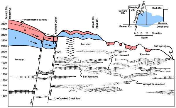
In the Meade-Clark County region a combination of geologic factors has given rise to the extensive development of solution-subsidence depressions. Faults cut both Pliocene-Pleistocene sediments, which contain fresh water under hydrostatic pressure, and Permian strata containing numerous beds of salt and gypsum. As pointed out by Frye and Schoff (1942, p. 34), the local structure allows fresh artesian water to circulate down fault zones into Permian rocks at depth, and eastward to a point of discharge, which is lower in elevation than the area of water ingress (Fig. 2). This structure has localized the sinks east of the faults. Since the faults are dated as early Pleistocene, developments of the solution-subsidence features can hardly antedate mid-Pleistocene time.
Figure 2--Generalized section through Meade basin and area immediately adjacent to east showing supposed course of circulating ground water and development of solution-subsidence features. Arrows indicate inferred directions of ground-water flow (after Frye and Schoff, 1942, p. 37). Insert map shows location of major faults in Meade County and the area principally affected by solution-subsidence features. A larger version of this figure is available.
The youngest depressions in western Kansas of sufficient size to attract regional notice developed in Wallace County in 1926 (Moore, 1926) and Hamilton County in 1929 (Landes, 1931). Origin of the Wallace County sink by solution of Cretaceous chalk at a depth of a few hundred feet and subsequent collapse of the near-surface rocks has been described by Moore (1926) and Elias (1930, 1931).
The development of this depression is described by Moore (1926, p. 130) as follows.
On the morning of March 9, 1926, a certain rancher, living about five miles east of the little town of Sharon Springs on the plains of western Kansas, chanced to see across the fields a dun-colored smoke. Hasty investigation revealed a newly formed, great yawning hole at the edge of the gently rounded bluff that here looks down on the dry sandy flat of Smoky Hill River. The cloud was dust. Excited word was broadcast by the press that the bottom was dropping out of Smoky Hill River, that a volcanic explosion of some sort was in full blast, or maybe a great gas blowout was in process of blowing.
According to reliable report the opening was at first something over fifty feet in diameter and appeared to be some hundreds of feet deep. Two streams of water from the underflow of Smoky Hill River were cascading into the depths sounding distantly on rocks below.…
A systematic series of soundings of the pond revealed a gradual increase in depth of water to about fifty feet, but in an area comprising about one seventh of the bottom the soundings increased very suddenly to 160 or 170 feet. A survey showed that the depression formed by the subsidence has a volume of a little over one and a half million cubic feet. Taking into account the volume which is occupied by the fallen rock debris, which by reason of its fragmentation may be assumed to fill a space at least 20 to 30 percent greater than its original volume, the size of the cavity under ground must be large. The depth from the original surface to the top of the material filling the deeper part of the hole is 245 feet; the depth to the bottom of the original cavity may be 500 feet, although this is only an approximate estimate.
Although insoluble Pierre shale underlies the surface of much of central Wallace County, it is immediately underlain by 700 feet of Niobrara chalk and chalky shale. Furthermore, in addition to the subsidence of 1926, several other depressions occur in the same areas and these display different stages of destruction by erosion. That their age may not be great is suggested by the observed rapid rate of rim erosion in the 1926 sinkhole.
Cavern development in chalk is not a commonly described feature but in central westernmost Kansas the evidence of chalk solution, probably aided locally by circulation along fault zones, as postulated by Moore and by Elias seems conclusive. The requirements for sink development of this type include a section of thick Cretaceous chalks overlain by no more than a few hundred feet of insoluble shales and a structural setting that would permit adequate circulation of fresh waters through beds generally displaying extremely low permeabilities. In areas where the near-surface insoluble beds are several hundred or more feet thick, this type of sink probably cannot occur. Such judgment is confirmed by test drilling in an area where 500 to 700 feet of Pierre shale overlies Niobrara chalk in Thomas County (Frye, 1945). In that area the Pierre shale floor does not reflect the depressions that occur on the surface. Perhaps Wallace, Logan, and Hamilton (Smith, 1940) counties are the only areas in western Kansas where depressions have been produced by solution of Cretaceous chalks.
Solution cavities of sufficient size to cause surface depressions in western Kansas are possible only in Cretaceous chalks and Permian salt and gypsum. In western Texas and eastern New Mexico, thick beds of caliche or limestone occur in the upper part of the Ogallala formation (Pliocene) and it has been suggested that some depressions in that area are produced by solution of this Pliocene caliche. In western Kansas, however, most of the calcium carbonate in the Ogallala formation consists of cement in sand, silt, and gravel beds. Limestone beds occur in the formation at only a few localities and at all observed occurrences such beds are quite thin; therefore, it is judged that large solution cavities could not be formed in the Ogallala.
Localized deflation and deposition by wind action is a common occurrence in many semiarid and arid regions. In the sand-dune tracts south of Garden City and in the Great Bend region, hundreds of undrained depressions have been produced by wind action in shifting sand (Smith, 1940). Such blowouts and interdune depressions are clearly recognized and adequately described; they need no further comment here.
The effect of wind action on silt-mantled uplands is not so clearly understood. Much of the Kansas High Plains surface, mantled by late Pleistocene loess, is dotted by hundreds of shallow saucer-shaped depressions (Fig. 1; pls. 2A-D). Although these shallow depressions may have diverse modes of origin, it seems probable that wind action has played an important role. In the Texas High Plains, comparable features have been attributed to wind scour (Evans and Meade, 1945). The depressions in the Texas plains commonly are accompanied by a low dune on the lee side and this association strongly suggests that the dune is formed by material derived from the basin floor. Although recognizable lee dunes are rare on the High Plains of Kansas, those which occur (Frye, 1946) probably have a similar origin.
Elongate troughs found on the upland surface in Cheyenne County, Kansas, contain strings of shallow depressions on their floors. The floors are immediately underlain by Ogallala rocks and the ridges are composed of Peoria and Bignell loesses. Since these features are localized near a probable loess source, and since some of the troughs are not occupied by through drainage, they may be the result of localized loess deposition in the form of longitudinal loess dunes.
At some places in northwestern Kansas where the upland mantle of late Pleistocene loess is thick, shallow depressions may be due to minor irregularities of loess deposition on a slightly dissected surface; to initial loess drift into shallow, pre-existing valleys; and to differential compaction of thicker loess deposits over shallow former valleys. Locally, alignment of shallow depressions roughly parallel to existing tributary drainage suggests partial control by earlier erosional valleys. That these northwestern Kansas features are not due to solution-subsidence is indicated by the large thickness of insoluble rock (1,000 feet of Pierre shale) above the shallowest soluble Cretaceous rocks, by the relatively low content of soluble material in the Ogallala formation, and by test drilling (Frye, 1945), which shows no reflection of the depression in the Pierre shale surface. Small depressions that may be the result of compaction of water-laid silt over former small valleys occur along the north side of Smoky Hill Valley in Ellis County.
North of Great Bend and east of Hoisington in Barton County is located Cheyenne Bottoms, considered by some workers (Schoewe, 1949, p. 296) to be the result of solution at undetermined depth and subsequent subsidence. This depression, perhaps the most controversial in Kansas, is 10 miles across and occurs north of the Arkansas River. The area has been described by Schoewe (1949, p. 294-296). In 1897, Haworth (p. 43-45) suggested origin by drainage changes and unusual deposition.
Fent (1950) discussed the Pleistocene drainage history of south-central Kansas and proposed that the Cheyenne Bottoms are the result of the placement of thick late Pleistocene alluvial fill in an earlier Pleistocene valley. The abnormal alluviation resulted from Wisconsinan captures by the Arkansas River. Fent is of the opinion that the low ridge on the southeastern side of Cheyenne Bottoms is the result of accumulation of dune sand and loess on the surface of the alluvial plain. Fent's hypothesis fits well the observed facts and places this depression in the category of initial depositional features.
Previous--Start Page || Next--Differential Silt Infiltration
Kansas Geological Survey, Geology
Placed on web September 2005; originally published March 15, 1951.
Comments to webadmin@kgs.ku.edu
The URL for this page is http://www.kgs.ku.edu/Publications/Bulletins/86_1/page2.html