![]()
Prev Page--Contents || Next Page--Stratigraphy
Introduction
Purpose of the study
Chalk is the common source of pure, soft, fine-grained calcium carbonate called "whiting" used by paint, putty, rubber, and chemical manufacturers. Raw chalk of Cretaceous age is shipped from Europe and processed for whiting on the Atlantic coast. During the war much study was applied to grinding hard limestone as a substitute for chalk. A large deposit of Cretaceous chalk has been recognized in Kansas for almost a hundred years. The enormous tonnage available and wide range of commercial applications suggest a possible whiting industry for the State. The purpose of this study is to determine the chemical and petrographic properties of this chalk throughout its belt of outcrop for comparison with the chemical and physical specifications for commercial whiting.
Distribution
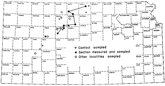
The Fort Hays chalk member of the Niobrara formation crops out over a wide area from north-central to western Kansas. The outcrop extends from the Kansas-Nebraska line in Jewell County southwestward to Finney County. A few isolated outcrops occur in Hamilton County adjacent to the Colorado-Kansas border. The distribution of the outcrops that were measured and sampled is shown in Figure 1.
Figure 1--Localities from which samples of Fort Hays chalk were selected for study.
Field sampling
The wide distribution of the Fort Hays and the nature of the intended analyses made it necessary to limit the amount of sampling. Where outcrops represented most of the member the section was measured and samples were taken from (a) the basal bed just above the contact zone, (b) the top of the basal bed, (e) one-quarter the distance up the measured section, (d) one-half the distance, (e) three-fourths the distance, and (f) the top bed; if the top was weathered, the sample (f) was taken from the top consolidated bed. Other samples were taken without reference to stratigraphic position, and several samples were collected from the Codell sandstone and the Blue Hill shale member of the Carlile shale, immediately below the Fort Hays. In each case a fresh composite sample averaging about 10 pounds was taken in the field.
Table 1 gives the location of outcrops sampled and the abbreviation used for each.
Acknowledgments
Dr. R. M. Dreyer, Chairman of the Department of Geology, University of Kansas, supervised the petrographic work done by Dubins and reported here. An electron micrograph of chalk was obtained from Northwestern University by Dr. Dreyer. We express our thanks also to the many landowners and pit and quarry operators who aided us in this work and permitted us to examine outcrops on their property.
Prev Page--Contents || Next Page--Stratigraphy
Kansas Geological Survey, Geology
Placed on web Oct. 6, 2008; originally published Feb. 1949.
Comments to webadmin@kgs.ku.edu
The URL for this page is http://www.kgs.ku.edu/Publications/Bulletins/82_1/02_intro.html