Kansas Geological Survey, Bulletin 76, part 2, originally published in 1948
Originally published in 1948 as Kansas Geological Survey Bulletin 76, part 2. This is, in general, the original text as published. The information has not been updated. An Acrobat PDF version of this report is available (4 MB).
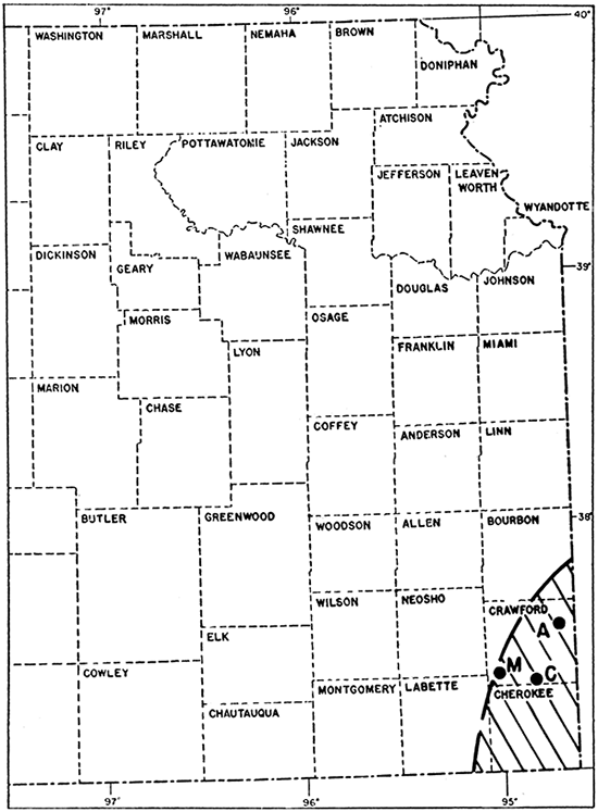
Crawford and Cherokee Counties (Fig. 1.) comprise one of the principal industrial areas in Kansas, owing to the coal and lead and zinc mines and the many related industries located there. The cities, mines, and industrial plants are supplied with water from deep artesian wells, and many ground-water problems not encountered elsewhere in Kansas are found in this area.
Figure 1--Index map of eastern Kansas showing the location of Arma, McCune, and Cherokee in Crawford County. The heavy dashed line represents the approximate northwestern limit of potable water supplies from Ordovician rocks in Kansas.
An investigation of the ground-water resources of pre-Pennsylvanian rocks in southeastern Kansas was begun in 1942 by the Geological Survey, U. S. Department of Interior, and the State Geological Survey of Kansas in cooperation with the Division of Sanitation of the Kansas State Board of Health and the Division of Water Resources of the Kansas State Board of Agriculture. G. E. Abernathy of the State Geological Survey and C. C. Williams of the Federal Survey were assigned to the study, A preliminary report on the ground-water resources of southeastern Kansas was prepared by Abernathy in 1941.
During the course of field work in Crawford County the author visited many wells in which contamination from beds above the fresh-water beds, as a result of faulty casings, was suspected, Pumping tests were made at municipal wells at Arma, McCune, and Cherokee suspected of having leaking casings, and the wells were shown to be contaminated. This paper describes the causes and results of intrusion of highly mineralized water in municipal and industrial wells in southeastern Kansas, and directs attention to methods of detecting intrusion and repairing damaged wells.
The Ordovician rocks tapped by deep wells in southeastern Kansas crop out between the area shown on Figure 1 and the axis of the Ozark dome in south-central Missouri. The rocks dip gently westward and northwestward and are encountered at increasingly greater depths westward in Kansas as far as the buried Nemaha ridge. The ultimate source of the water pumped in southeastern Kansas is precipitation which falls on the rocks in the area of outcrop in Missouri and which moves slowly westward through the rocks in the direction of the regional dip.
The Cherokee shale of Pennsylvanian age underlies the surface in most parts of Crawford and Cherokee Counties in which deep artesian wells are located, and the outcrop of the Fort Scott limestone also of Pennsylvanian age roughly corresponds to the northwestern limit of potable water in the Ordovician rocks penetrated by the deep wells. In west-central Crawford County some deep wells are located in a comparatively small irregular area underlain by the Fort Scott limestone and Labette shale both of Pennsylvanian age. In southeastern Cherokee County, principally southeast of Spring River, where the Cherokee shale is absent, the surface is underlain by Mississippian limestones.
A representative section of the rocks penetrated by water wells in southeastern Kansas is shown in the graphic log of a well drilled by the City of Arma (Fig. 2). This well was begun in the Englevale channel sandstone and penetrated the Fort Scott limestone, part of which is missing, and a full thickness of the Cherokee shale.
Figure 2--Graphic log of city well no. 2 at Arma, Kansas. Correlation by O. S. Fent, Wallace Lee, and Charles C. Williams.
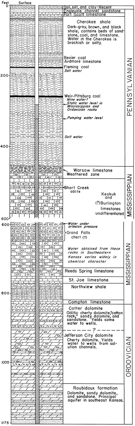
The Cherokee is 420 feet thick at Arma and is predominantly gray clayey and silty micaceous shale. Very dark or black carbonaceous shale occurs at several horizons, and there are several beds of coal which in different places are of workable thickness. Sandstone occurs in different parts of the Cherokee, but most of the beds seem to lack regional persistence. Some of the sandstones are highly lenticular bodies and produce oil and gas near McCune in western Crawford County and elsewhere. Most of the sands in the Cherokee shale contain highly saline water, except in the area of outcrop, and these beds contribute undesirable water to some defective deep wells in this area. Limestone beds are not prominent in the Cherokee, but there are a number of thin dark-gray beds, some of which are local in distribution. The Ardmore limestone member (Fig. 2) is the most important and persistent limestone bed.
Cherty limestone beds comprise most of the rocks of Mississippian age that underlie the Cherokee shale. These beds are 320 feet thick at Arma (Fig. 2), and include the Warsaw, Keokuk, Burlington (?), Reeds Spring, and St. Joe limestones. Chert is very abundant in parts of these units. Ground water is found in the weathered zone at the top of the Mississippian section in Crawford and Cherokee Counties. In some places cherty beds identified as the Grand Falls chert (?) are an important aquifer. This chert is not identified definitely as to stratigraphic relations; it may be a concentrate of dense silica in upper Reeds Spring beds, in Burlington limestone, or in the lower part of the Keokuk limestone. At Arma, water was encountered in the Grand Falls (?) at 600 feet and rose 300 feet in the hole. In other places, so far as known, the Grand Falls chert (?) is not porous and contains no water. Ground water in the Mississippian rocks in this area differs greatly in chemical character. In most of this area the Northview shale and the Compton limestone occur at the base of the Mississippian section below the thick cherty limestones (Lee, 1940, pp. 30-33).
In order to obtain adequate supplies of ground water, most deep wells in southeastern Kansas penetrate the Cotter and Jefferson City dolomites and Roubidoux formation of Ordovician age (Fig. 2). The Roubidoux supplies water more abundantly to deep wells in this area than the Cotter and Jefferson 'City, although all these rocks contribute to the yield of most of the wells. Some wells in southeastern Kansas penetrate Cambrian rocks at greater depths, but most wells end in the Roubidoux. Dolomite, sandy dolomite, and partly cemented sandstone comprise the Roubidoux formation, and water occurs in the pore spaces between the sand grains in the sandstones and in small cracks, solution channels, and other small openings in the dolomite. Ground water in the Roubidoux formation and other rocks of Ordovician age and of Cambrian age is under artesian pressure and rises a considerable distance above the aquifer. The depth to water level below land surface depends on geographic location within the area and the extent of ground-water development locally, but ranges from about 100 to 300 feet in southeastern Kansas.
The chemical character of the water in the pre-Pennsylvanian rocks in this area varies widely and, in general, the water becomes more highly mineralized as it moves westward through the rocks from their outcrop in Missouri. At Baxter Springs in southeastern Cherokee County the water from deep wells contains about 350 parts per million of dissolved solids, whereas deep wells at McCune, which is near the western edge of the area, yield water containing dissolved solids in excess of 1,500 parts per million. Similarly, the chloride and hydrogen sulfide in the water increase westward and the water is undesirable for most purposes west of the dashed line shown on Figure 1.
As noted above, the water contained in the sandstones in the Cherokee shale is highly mineralized and saline in most parts of this area. All the deep wells in southeastern Kansas are cased through the Cherokee shale and in some places through the Mississippian limestone. The casings are not grouted in most of the wells and are in contact with the beds in the Cherokee containing salt water; consequently, many casings have been badly corroded in this zone of contact, allowing highly mineralized water to enter the wells. Other casings are not firmly seated below the Cherokee shale and salt water moves downward outside the casing and enters the wells. When salt water gains admittance to wells through corroded or otherwise faulty casings, it moves downward to the water level in the wells and slowly sinks, owing to its greater specific gravity. The corrosion of the pumping equipment resulting from this intrusion or from the intrusion of water containing hydrogen reduces the efficiency of the pumps and increases the cost of operation, and in addition undesirable water is contributed to the distribution systems. Ultimately the loss of pumping efficiency and increased cost of operation of defective wells become so great that pumping equipment must be removed and repaired at considerable expense.
During recent years the Federal Geological Survey has been called upon to investigate many areas in which the water obtained from wells has been contaminated by salt water, and several methods of locating salt-water leaks have been devised by members of the Survey and others. These methods were described and discussed by Livingston and Lynch in 1937. Of the several methods useful in detecting salt-water contamination in wells, the method most applicable to conditions in southeastern Kansas seems to be the pumping method (Livingston and Lynch, 1937, pp. 4-8) because most leaks occur above the static water level in the wells, and the most noticeable contamination occurs during periods when pumps are not in operation.
In the pumping method samples of water are taken at frequent measured time intervals, beginning with the starting of the pump. The first samples are taken at intervals of a few seconds; later the intervals are lengthened because the salinity of the water usually becomes more nearly uniform as pumping continues. The samples are tested for chloride by ordinary laboratory methods, and then curves are plotted showing the change in salinity that occurs in the water as pumping progresses. The best results are obtained when the tests are run after the wells have been idle for some time. The pumping method of investigation is applicable only to the study of wells that can be pumped readily, but it serves well to show the degree of contamination. It is not possible with this method to locate the exact position of a leak in the casing because the water level is below the leak in most wells in this area, but if accurate logs of the wells showing location of the sands in the Cherokee shale are available, they may be used for this purpose if the pumping test shows evidence of contamination.
It seems probable that many of the older deep wells in southeastern Kansas may have become contaminated, especially the abandoned wells at worked-out coal mines. Of the several active wells suspected of having leaking casings, three municipal wells were selected for testing (Fig. 1) and the results obtained using the pumping method at these wells are presented below.
Pumping test at McCune--The City of McCune is supplied with water from one well which is 1,292 feet deep and equipped with a deep-well turbine pump yielding 110 gallons a minute, principally from the Roubidoux formation. The depth to water level is about 185 feet below land surface when the well is not pumping. The well is pumped about 2 hours daily to supply the needs of the city and is idle the remainder of the time. McCune is near the west edge of the area from which usable water can be derived from deep sources and uncontaminated water from this well contains more than 1,500 parts per million of dissolved solids. Contamination by water in the Cherokee shale renders water from this well undesirable.
The well at McCune had been idle for 12 hours before the test was made. After the pump was started 26 samples were collected at frequent intervals during the first hour of pumping and the results are given in Table 1. The water was black with ferrous sulfide during the first few minutes of pumping, indicating corrosion of casing and pumping equipment during the period when the pump was idle, but later became clear. The chloride content decreased slightly during the first 8 minutes of pumping, then increased abruptly from 725 to 1,290 parts per million during the next 2 minutes of pumping, reached 2,725 parts per million after 15 minutes, remained high for the next 10 minutes, and then dropped abruptly, eventually to 750 parts at the end of 1 hour's pumping. The data given in Table 1 are shown graphically in Figure 3 and indicate rather clearly that there is an appreciable leak in the casing of the well.
Table 1--Analyses of water from McCune City well. (Analyses by H. A. Stoltenberg, Water and Sewage Laboratory, Kansas State Board of Health. Constituents are given in parts per million.)
| Sample No. |
Time after pump began delivery (minutes) |
Chloride | Manganese | Iron |
|---|---|---|---|---|
| 1 | 0 | 890 | 6.7 | 2580 |
| 2 | .5 | 880 | .7 | 81 |
| 3 | .75 | 890 | .1 | 36 |
| 4 | 1. | 880 | .4 | 190 |
| 5 | 1.5 | 870 | .2 | 170 |
| 6 | 2. | 885 | .1 | 34 |
| 7 | 2.5 | 905 | 10 | |
| 8 | 3. | 890 | 4.6 | |
| 9 | 3.5 | 895 | 7.0 | |
| 10 | 4 | 890 | 6.0 | |
| 11 | 4.5 | 860 | 5.8 | |
| 12 | 5 | 840 | 8.0 | |
| 13 | 5.5 | 780 | 4.4 | |
| 14 | 6 | 750 | 4.6 | |
| 15 | 6.5 | 740 | 4.2 | |
| 16 | 7 | 735 | 3.2 | |
| 17 | 8 | 725 | 3.2 | |
| 18 | 10 | 1290 | 3.4 | |
| 19 | 12 | 2150 | 3.1 | |
| 20 | 15 | 2725 | 5.3 | |
| 21 | 20 | 2305 | .6 | |
| 22 | 25 | 1180 | .5 | |
| 23 | 30 | 770 | .1 | |
| 24 | 40 | 695 | 0 | |
| 25 | 50 | 780 | .4 | |
| 26 | 60 | 750 | .4 |
Pumping test at Cherokee--The City of Cherokee is supplied with water from two deep wells penetrating the Roubidoux formation and located a few feet apart in the same pump house. The wells are similar and are pumped alternately at 200 gallons a minute for about 10 hours each day. The east well, which was tested, is 918 feet deep and the static water level is 202 feet below land surface. The well at Cherokee was tested by the pumping method for 1 hour, and samples were collected at frequent intervals during the pumping period as at McCune. The wells at Cherokee had been idle for 62 hours before pumping. The results obtained from the test are given in Table 2 and are shown on Figure 3.
Figure 3--Graphs of analyses of water collected from the city wells at McCune, Arma, and Cherokee, Kansas.
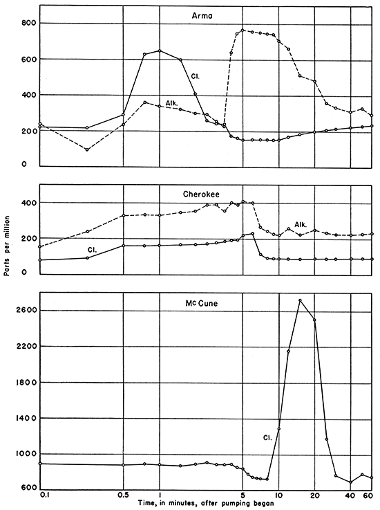
Table 2--Analyses of water from Cherokee City well (Analyses by H. A. Stoltenberg, Water and Sewage Laboratory, Kansas State Board of Health. Constituents are given in parts per million.)
| Sample No. |
Time after pump began delivery (minutes) |
Chloride | Alkalinity as CaCO3 |
Iron (by appearance) |
|---|---|---|---|---|
| 1 | 0 | 80 | 176 | Very high |
| 2 | .25 | 94 | 239 | Very high |
| 3 | .50 | 160 | 328 | High |
| 4 | .75 | 161 | 332 | Mod. high |
| 5 | 1 | 162 | 331 | Mod. low |
| 6 | 1.5 | 166 | 344 | Mod. low |
| 7 | 2 | 167 | 356 | Mod. low |
| 8 | 2.5 | 169 | 389 | Mod. low |
| 9 | 3 | 178 | 389 | Mod. low |
| 10 | 3.5 | 186 | 356 | Mod. low |
| 11 | 4 | 187 | 400 | Mod. low |
| 12 | 4.5 | 190 | 392 | Mod. low |
| 13 | 5 | 221 | 406 | Mod. low |
| 14 | 6 | 224 | 400 | Mod. low |
| 15 | 7 | 109 | 262 | Low |
| 16 | 8 | 97 | 241 | Low |
| 17 | 9 | 95 | 225 | Low |
| 18 | 10 | 95 | 221 | Low |
| 19 | 12 | 92 | 260 | Very low |
| 20 | 15 | 94 | 223 | Very low |
| 21 | 20 | 93 | 252 | Very low |
| 22 | 25 | 94 | 236 | Very low |
| 23 | 30 | 94 | 226 | Very low |
| 24 | 40 | 94 | 224 | Very low |
| 25 | 50 | 93 | 225 | Very low |
| 26 | 60 | 93 | 232 | Very low |
The chloride content of the water from this well increased slightly during the first quarter-minute of pumping, and by the time half a minute of pumping had elapsed, it increased abruptly from 94 to 160 parts per million. The chloride content remained high and increased somewhat to a maximum of 224 parts at the end of 6 minutes of pumping, when it decreased rather rapidly to 97 parts at the end of 8 minutes and then remained nearly uniform throughout the rest of the 1-hour pumping period. This seems to indicate a leak in the casing through which water high in chloride finds its way into the well, but the fact that the chloride content during the. pumping test did not rise to a higher value than that given in Table 2 seems to indicate that the leak may have been small. The alkalinity of the water became somewhat higher during the interval when water high in chloride was being discharged from the pump, and the iron content was very high at first, indicating corrosion of the pumping equipment.
Pumping test at Arma--In 1942, at the time of this test, the City of Arma was supplied with water from one well 1,175 feet deep and equipped with a deep-well turbine pump yielding 230 gallons a minute. The static water level in the well was 280 feet below land surface, and the well was pumped 3 hours daily. The well was idle for 24 hours before the test was made. The results of the test are given in Table 3 and are shown on Figure 3.
Table 3--Analyses of water from Arma city well (Analyses by H. A. Stoltenberg, Water and Sewage Laboratory, Kansas State Board of Health. Constituents are given in parts per million.)
| Sample No. |
Time after pump began delivery (minutes) |
Chloride | Sulfate | Alkalinity as CaCO3 |
Iron (by appearance) |
|---|---|---|---|---|---|
| 1 | 0 | 225 | 133 | 238 | Very high |
| 2 | .25 | 218 | 308 | 96 | Very high |
| 3 | .50 | 290 | 107 | 238 | Very high |
| 4 | .75 | 630 | 361 | Mod. high | |
| 5 | 1 | 650 | 339 | Mod. high | |
| 6 | 1.5 | 600 | 26 | 326 | Mod. high |
| 7 | 2. | 415 | 300 | Mod. low | |
| 8 | 2.5 | 260 | 287 | Mod. low | |
| 9 | 3 | 245 | 53 | 257 | Mod. low |
| 10 | 3.5 | 245 | 233 | Very low | |
| 11 | 4 | 175 | 28 | 641 | Very low |
| 12 | 4.5 | 165 | 751 | Very low | |
| 13 | 5 | 155 | 28 | 770 | Very low |
| 14 | 6 | 155 | 758 | Very low | |
| 15 | 7 | 155 | 16 | 755 | Very low |
| 16 | 8 | 155 | 749 | Very low | |
| 17 | 9 | 155 | 748 | Very low | |
| 18 | 10 | 155 | 28 | 704 | Very low |
| 19 | 12 | 170 | 32 | 664 | Very low |
| 20 | 15 | 185 | 514 | Very low | |
| 21 | 20 | 200 | 484 | Very low | |
| 22 | 25 | 210 | 360 | Very low | |
| 23 | 30 | 215 | 54 | 336 | Very low |
| 24 | 40 | 225 | 310 | Very low | |
| 25 | 50 | 230 | 330 | Very low | |
| 26 | 60 | 235 | 62 | 296 | Very low |
The chloride content of the water from this well increased markedly to 650 parts per million after 1 minute of pumping, but decreased again to almost its former value at the end of about 3 minutes of pumping. As the water pumped during this short interval had a chloride content nearly three times the normal chloride content of water pumped at Arma, there seems to be clear indication of leakage of water from the Cherokee shale into the casing at some point. Analyses of water from this well showed also that after 3% minutes of pumping the alkalinity of the water increased rather abruptly to a high value and remained high until about 15 minutes of pumping time had elapsed, when the alkalinity gradually decreased. The analyses show further that during the pumping interval when the alkalinity was at a maximum the chloride and sulfate contents were at a minimum. These facts seem to indicate another and more pronounced leakage of a totally different type of water than was recorded during the earlier pumping interval. According to the reported history of the well it seems probable that the well passes through workings of an abandoned coal mine, and it was suspected that mine water might be leaking into the well. It was also expected that if such leakage were detected the mine water might be acidic in character, but it was recognized that if the mine had been completely filled with water for some time the mine water might have become neutral or slightly alkaline. There is some indication of acid water in the sample collected after a quarter of a minute of pumping had elapsed, when the alkalinity was only 96 parts per million and the sulfate was 308 parts, but water of this type appeared in the record for only a very short interval of time and its significance is not wholly clear. The main leakage, coincident with the highest alkalinity during the pumping period from 4 to 15 minutes, is not the type of water to be expected from a coal mine in this area and the source of this water is puzzling. About all that can be said for certain is that it is a type of water totally different from that normally pumped from the deep water-bearing formations and probably is leaking into the well through or around the casing.
Advice from the Geological Surveys and the Kansas State Board of Health to municipalities and industries in this area contemplating drilling new water wells to the deep aquifers includes the recommendation that casings be grouted through the Cherokee shale, and through the Mississippian limestones if the water encountered there is of inferior quality. This method, which consists of forcing cement into the annular space between the casing and the rock wall of the well, is the only sure means of protecting the casing against corrosion by highly mineralized water and is good insurance against costly repairs. Wells which were not so protected when drilled can be repaired and made safe from contamination by recasing and grouting. In some wells new casings of slightly smaller diameter have been inserted within the old casings and cement has been forced under pressure into the annular space between the new inner and old outer casings. It seems probable, however, that many wells in this area are still being contaminated by highly mineralized water which could be excluded.
Memoranda giving the results of' the tests described above were sent to the officials of the three cities having the defective wells. As a 'result, the City of Arma subsequently drilled a new well (Fig. 2) which has been properly cased and grouted, and the older well at Arma is being reconditioned; similarly, well improvements have been made at Cherokee. After learning the results of the pumping tests, all three of the cities pumped water to waste each day for periods of time sufficient to clear the wells of contamination before introducing the flow of the wells into the distribution systems. It seems that other cities and industrial plants in southeastern Kansas may profitably use the pumping method in testing wells for contamination.
Abernathy, G. E., 1941, Ground-water resources of Mississippian and older rocks in Bourbon, Crawford, Cherokee, and Labette Counties, southeastern Kansas: Kansas Geol. Survey, Bull. 38, pt. 8, pp. 221-236, figs. 1 and 2. [available online]
Lee, Wallace, 1940, Subsurface Mississippian rocks of Kansas: Kansas Geol. Survey, Bull. 33, pp. 1-114, figs. 1-4, pls. 1-10. [available online]
Livingston, Penn, and Lynch, Walter, 1937, Methods of locating salt-water leaks in water wells: U.S. Geol. Survey, Water-Supply Paper 796-A, pp, 1-20, figs. 1-5, pls. 1-9. [available online]
Kansas Geological Survey, Contamination of Deep Water Wells in Southeastern Kansas
Placed on web Sept. 12, 2016; originally published April 1, 1948.
Comments to webadmin@kgs.ku.edu
The URL for this page is http://www.kgs.ku.edu/Publications/Bulletins/76_2/index.html