![]()
Prev Page--Contents || Next Page--Stratigraphy, Pre-Cambrian to Ordovician
Introduction
The investigation of the stratigraphy and structural development of the Salina basin was carried on during the period from September 1943, to June 1946, under a cooperative agreement between the State Geological Survey of Kansas and the U.S. Geological Survey,
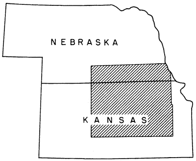
The area studied (Fig. 1) includes not only the Salina basin but also parts of the adjacent Nemaha anticline and Central Kansas uplift. The axis of the Salina basin, which was an area of post-Mississippian structural subsidence, extends northwest and southeast from Saline County, Kansas. Most of the Salina basin lies in Kansas, but in the earlier stages of its development the synclinal warping extended into southern Nebraska.
Fig. 1--Map of Kansas showing the area covered by this report.
The report follows in general the plan of a previously published report on the Forest City basin (Lee, 1943). The analysis of the complex regional stratigraphy and structure with which the report is primarily concerned will be useful in guiding future drilling, not only in this area but also in bordering areas where the relations of overlap and regional structure are similar and have an important bearing on the accumulation of oil. Local structural features to which oil company geologists give special attention have not in general been the subject of study in the present investigation.
The data upon which the report is based were derived entirely from the cuttings and logs of wells. The criteria by which most of the formations are identified were determined from the outcrops of the formations in many areas distant from the Salina basin.
Most of the several thousand wells that have been drilled in the Salina basin are in the developed southern and southwestern parts. The wells are more widely scattered in the northern part of the basin. Sets of samples from more than 300 wells drilled by both rotary and cable tools were examined microscopically. The accurate detail thus secured was augmented by a considerable number of sample logs which were prepared by company geologists. All available electric logs and drillers logs in which the datum beds could be identified were used in the preparation of the accompanying map that shows the thicknesses of different parts of the sequence of the sedimentary rocks. Considerably more than 2,000 well logs were studied and correlated and the logs of many hundred more wells were examined. Some 1,600 logs of wells, most of which are in the southern part of the basin, were selected from a file of several thousand for use in the study of the Pennsylvanian and Permian rocks.
Many drillers logs were not used owing to evident inaccurate logging or obvious unrecorded corrections of depth. The logs of many early wells designate as sand all cherty beds, water-bearing beds, and coarsely sucrose dolomites. Through a comparison of these old logs with electric and sample logs, it has been possible to identify essential datum beds in many logs that were previously considered to be of little value.
Some sets of rotary samples were found to be so badly contaminated that critical points could not be determined. Also, in some sets of rotary samples many contacts were determined with doubtful accuracy. These contacts include (1) the limits of soft beds of sandstone, such as the St. Peter sandstone, (2) the base of some limestones such as the Hertha limestone where the Pleasanton shale is thin, and (3) the base of the Devonian rocks. Relatively few drillers logs of rotary wells contributed essential information unless they were accompanied by determination of datum beds by company geologists.
Drillers logs showing abnormal thicknesses were discarded unless they were supported by the logs of other wells in the same vicinity. Sample logs showing unusual thicknesses or other features have generally been plotted although it is recognized that they also are subject to differences of interpretation and to inaccuracies of sampling, recording, and depth.
In consequence of the varying degrees of accuracy of the data, the maps that show the thicknesses of the different parts of the rock sequence of the Salina basin have been prepared with lines spaced at 50-foot intervals. Intervals of 25 feet or less would doubtless bring out many local structural features, particularly in oil fields where local deformation probably accompanied regional deformation throughout Pennsylvanian and Permian time. In densely drilled areas only one or two wells in a land section were used because the object of the investigation was the study of regional and not local deformation.
The major structural features of eastern and central Kansas are shown in Figure 2. Some of them were developed contemporaneously, but others were developed at different times. The structural features that were formed before the deposition of rocks of Simpson age are shown in Figure 2A. These are the Southeast Nebraska arch, a structural basin parallel and to the west, and a somewhat vaguely located arch still farther west. Later structural features (Fig. 2B) were formed between St. Peter time and early Mississippian time. They include the Chautauqua arch, the Central Kansas uplift, and the North Kansas basin. The most prominent of the principal structural features formed between the end of Mississippian time and middle Permian time (Fig. 2C) are the Nemaha anticline, the Forest City and Cherokee basins, the Salina basin, and the Central Kansas uplift. Also, a number of secondary folds parallel to the Nemaha anticline were formed. The only movements of the Chautauqua arch after Chattanooga time that can be recognized by 50-foot thickness lines were confined to several minor northwesterly trending folds and the broad Bourbon arch that separated the Forest City and Cherokee basins during early Pennsylvanian deposition.
Fig. 2--Maps showing the principal structural features of Kansas. A, Known structural features active before St Peter time, indicated by distribution and thickness of pre-St. Peter formations. Data derived in part from Keroher and Kirby (1948). Southeast Nebraska arch shown by zero thickness line of pre-St. Peter dolomites (Lee, Grohskopf, Hershey, and Reed, 1946, sheet 1).
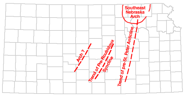
Fig 2B, Structural features developed between St. Peter time and Mississippian time. The North Kansas basin is shown as outlined by the 1,000-foot thickness contour of rocks between base of St. Peter sandstone and base of Mississippian limestones (Pl. 7), the Central Kansas uplift as outlined by the pre-Devonian outcrop of rocks of Simpson age (Pl. 5), and the Chautauqua arch by the pre-Chattanooga outcrop of the St. Peter sandstone (in part after McClellan, 1930).
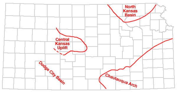
Fig 2C, Structural features that were developed between the end of Mississippian time and early Permian time. The Salina basin is shown as outlined by the 300-foot thickness contour of pre-Hertha Pennsylvanian rocks (Pl. 9), the Central Kansas uplift as outlined by the 50-foot thickness contour (Pl. 9), the Forest City and Cherokee basins as outlined by the 750-foot thickness line of the pre-Hertha Pennsylvanian rocks (Lee, Grohskopf, Hershey, and Reed, 1946, sheet 6).
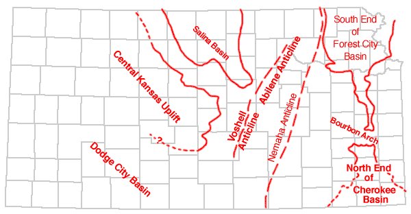
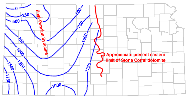
Fig 2D, Generalized present attitude of the top of the Stone Corral dolomite in the post-Permian and pre-Cretaceous synclinal basin. The contour interval is 250 feet. Since the deposition of the Cretaceous rocks, structural movements have raised the basin, tilted the Cretaceous toward the northeast, and in other ways have modified their original attitude.
The Salina basin was first defined by John S. Barwick (1928, p. 179) as "The pre-Pennsylvanian syncline bounded on the east by the Nemaha granite ridge, on the southwest by the Barton arch, and on the south by the saddle between the Chautauqua arch and the Barton arch. The basin continues northward into Nebraska where its exact termination is not known." The Barton arch, a name suggested by Barwick, is now generally known as the Central Kansas uplift, and since 1926 (Ley, 1926) the Nemaha granite ridge has been recognized as a post-Mississippian beveled anticline.
The Salina basin lies on the margin of an earlier structural basin referred to by John L. Rich (1933) as the North Kansas basin. The Salina basin had no separate existence until the uplifting of the Nemaha anticline destroyed the North Kansas basin and developed the Salina basin on the west and the Forest City basin on the east. These basins were at first structural basins revealed by the beveling of pre-Pennsylvanian rocks. During Pennsylvanian time, they were subsiding areas in which Pennsylvanian deposits accumulated in greater thickness than on the margins.
Terminology
Inasmuch as there is no standardized use of words for describing some of the textures of rock materials and insoluble residues, it is desirable to explain the meaning intended for certain descriptive terms used in this report.
Cotton rock is a soft porous siliceous rock or insoluble residue composed of white opaque uncemented microscopic particles of silica.
Dolomold (Ireland, 1947) is a term for the impression left by a dolomite crystal removed from chert or other materials in insoluble residues. Dolomolds may occur singly or be so numerous that they form a porous or spongy texture.
Drusy texture is applied to deposits of crystalline quartz formed in microscopic cavities.
Even-textured rock has a homogeneous character and is microscopically massive.
Grainy texture consists of microscopic crystals of limestone or dolomite or particles of silt sparsely distributed in a dull opaque usually calcareous matrix. The matrix in some rocks is cryptocrystalline, in others earthy. By changes in the character of the matrix, rocks having this texture may become sucrose dolomite or silty limestone.
Hackly texture is applied to broken quartz without crystalline faces.
Matted texture as applied to chert indicates closely packed fragments of silicified microfossils and sponge spicules cemented in a siliceous matrix.
Mottled is applied to parti-colored chert in patches without sharp margins; it is microscopic, but much coarser than stippled.
Porous texture is used for aggregates of quartz, chert, or other materials in which the intervening individual cavities are microscopic.
Semigranular texture is applied to coarsely crystalline grains, principally fossil fragments, in a microcrystalline matrix. In some rocks crinoidal limestones are semigranular.
Spongy texture refers to aggregates of quartz, chert, silt, or clay in insoluble residues from which the soluble matrix has been removed. The individual openings are submicroscopic.
Stippled indicates a dotted pattern on a smoothly broken chert surface due to the complete replacement by silica of rocks having grainy texture. The sharp outline of the replaced impurities in some zones is blurred and gives a cloudy margin to the replaced particles.
Streaked texture indicates the microfossiliferous content of matted chert that is imperfectly replaced or subsequently modified resulting in blurred outlines of the microfossiliferous constituents.
Sucrose texture refers to microscopically coarse or fine crystals--usually dolomite--packed closely (without matrix) like the grains of lump sugar.
Acknowledgments
The study of the Salina basin has been facilitated by the important accumulation of samples, plotted logs, and records in the files of the State Geological Survey of Kansas. The writers are greatly indebted to all those individuals who at one time or another collected, contributed, and preserved the samples of well cuttings in the files of the State Geological Survey and elsewhere and to the Kansas Geological Society whose foresighted officers, acting through the Well Log Bureau, have made available the priceless collections of well logs now on file.
For data of various kinds and for the use of sets of samples of wells not in the files of the State Survey, the authors are especially indebted to: George F. Berry, Cities Service Oil Company; John E. Galley, Shell Oil Company; William C. Imbt, Stanolind Oil and Gas Company; W. Morris Guthrey, The Texas Company; E. K. Edmiston, Auto-Ordnance Corporation; Mrs. Dollie Radler Hall, Amerada Petroleum Corporation; Virgil B. Cole, Gulf Oil Corporation; L. Murray Neumann and Wilford L. Cline, Carter Oil Company; R. E. Minniss, Jr. and William W. Mallory, Phillips Petroleum Company; and Harold O. Smedley, Skelly Oil Company; and to Walter A. Ver Wiebe, of the Geology Department of the University of Wichita. The authors thank L. W. Kesler and Frederick A. Bush of the Sinclair Prairie Oil company not only for samples but also for the use of cores from the Hollow pool of Harvey County.
The writers acknowledge with appreciation the cordial cooperation of G. E. Condra and E. C. Reed of the Nebraska Geological Survey in making available sample material and sample logs from southern Nebraska. Thanks are also rendered to J. M. Jewett of the Kansas Geological Survey for criticism of the Pennsylvanian section of the report and to Norman Plummer and Ada Swineford of the Kansas Geological Survey for help in the interpretation of the Cretaceous sections of the well logs.
The authors are indebted to Raymond P. Keroher and Jewell J. Kirby for stratigraphic sections and thickness data of the pre-St. Peter rocks published (1948) in their report "Upper Cambrian and Lower Ordovician Rocks of Kansas."
The work was directed by Wallace Lee who is responsible for the interpretation of the structural development of the area. The microscopic examination, lithologic descriptions, and correlation of the pre-Pennsylvanian samples are the work of Constance Leatherock who also prepared the thickness maps, cross sections, and the columnar section of Table 1. Theodore Botinelly examined the Pennsylvanian and Permian samples of numerous wells, correlated the post-Mississippian sections of well logs, and prepared thickness maps of the Pennsylvanian and Permian rocks and cross section X-X' and Y-Y'. Other geologists who worked briefly on the Pennsylvanian and Permian rocks at the beginning of the project were Harold L. Williams, formerly of the State Geological Survey, Clifford N. Holmes, who was transferred to another Geological Survey project, Merald E. Rhoades, who entered the Navy, and Warren Grunert, who joined the Army and was killed in parachute operations in Holland in 1944.
Prev Page--Contents || Next Page--Stratigraphy, Pre-Cambrian to Ordovician
Kansas Geological Survey, Geology
Placed on web Dec. 28, 2007; originally published Nov. 1948.
Comments to webadmin@kgs.ku.edu
The URL for this page is http://www.kgs.ku.edu/Publications/Bulletins/74/02_intro.html