![]()
Prev Page--Subdivisions || Next Page--Summary
Geologic Cross Sections
The cross sections published with this report are arranged to give as complete coverage of the state as possible. Diagrammatic summaries and index maps showing location of the cross sections are given in Figures 10 to 13. Four sections originating at as many points near the Kansas-Missouri boundary and extending into western Kansas are arranged at fairly regular intervals from Oklahoma to Nebraska. These intersect five sections which extend from the southern boundary of Kansas to northern Kansas or Nebraska and are arranged at intervals from east to west across the state.
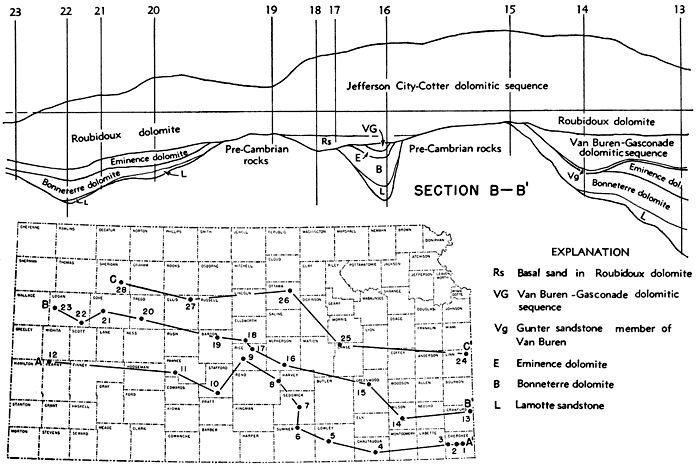
Figure 10--Diagrammatic cross section on line B-B' and index of sections.
General Discussion
The importance of a well to this type of investigation is almost proportional to the percentage of the total thickness of the rocks penetrated. Therefore, the significance of some of the wells studied necessarily is much greater than that of others.
The wells studied in the western part of the state, for the most part, are those that penetrate all or nearly all of the Upper Cambrian and Lower Ordovician beds that are present at the location of the well. Most of the wells that penetrate the entire Paleozoic section are dry holes or wells drilled on the margin of pools and abandoned early in the life of the pool. The evidence indicates that the uppermost deposits of pre-St. Peter age are absent in Kansas and the well logs probably do not include the maximum thickness of the pre-St. Peter sedimentary rocks once present.
Comparison of all the logs of wells that penetrate all or the greater part of the Upper Cambrian and Lower Ordovician beds present shows no outstanding characteristic of the dolomite that persists over a distance of more than a few miles. The insoluble residues, however, exhibit very persistent characteristics and can be identified across the state. These persistent zones are correlated with similar zones identified at the outcrop and in the subsurface of Missouri.
The persistent and diagnostic features of each of the subdivisions which are the basis of most of the correlations are shown in the plotted logs (Pl. 6) by different patterns.
- Sand in the Lamotte sandstone.
- Fine glauconitic sand in the Bonneterre dolomite.
- Quartzose chert, green shale, and pyrite in the Eminence dolomite (components of the Eminence residue not distinguished on the cross sections.)
- Sand in the Gunter sandstone member of the Van Buren formation.
- Chert in the Van Buren-Gasconade sequence.
- Sand in the Roubidoux dolomite.
- Chert in the Jefferson City-Cotter sequence and at the base of the Cotter sand.
These patterns serve to draw attention to outstanding features of the insoluble residues of each of the major subdivisions recognized in the subsurface of Kansas and emphasize the continuity of lithologic zones across the state.
Although sand may be the predominant constituent of the insoluble residue, it is commonly too small a percentage of the total sample to be plotted. Therefore, for those subdivisions that are identified on the basis of characteristic sand residues, the percentage of sand both in the insoluble residue (right hand column) and in the total sample (left hand column) are shown.
For subdivisions that are identified by a relatively large amount of residue consisting predominantly of chert, the percentage of chert in the total sample is plotted in the left hand column. The right hand column is left blank where cherty dolomites are indicated. The dotted pattern that generalizes the position of the sand zone at the base of the Cotter is an exception.
The space representing the material in the residue that was not found to be diagnostic of the subdivision was left blank in both columns of the logs represented on the cross section. No attempt has been made to show differences in character of the dolomites (1) because few dolomite types were persistent enough laterally or vertically to afford a criterion for correlation, and (2) because correlations were based for the most part on diagnostic material in the insoluble residue. Therefore, the space in the left hand column in which symbols representing dolomite types on the original log were plotted is left blank on the cross sections.
More detailed examination of samples from closely spaced wells doubtless would provide data that would permit recognition of the point of contact between some of the beds more precisely than is possible in the present report. However, it is believed that the contacts as indicated in the accompanying plotted logs are consistent with the purpose of the study and with the control available for it. Data for drawing the cross sections have been derived principally from the wells.shown on each. The thicknesses of the formations between wells and the points at which the formations wedge out were determined from the maps, showing the thickness and distribution.
Cross Section on Line A-A' (Fig. 11 and Pl. 6)
Section A-A' extends from Cherokee County in the extreme southeastern corner of the state northwestward to Kearny County, passing in westward order through Chautauqua, Cowley, Sumner, Sedgwick, Reno, Rice, Stafford, and Pawnee counties. The section covers a total distance of 427 miles, although the straight-line distance between the Cherokee County well (well 1) and the Kearny County well (well 12) is 370 miles.
Figure 11--Diagrammatic cross sections on lines A-A' and C-C'.
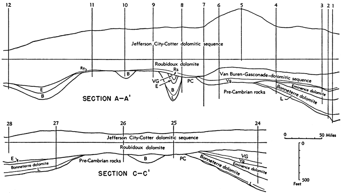
The formations immediately overlying the Pre-Cambrian surface are progressively younger from the eastern margin toward central Kansas. Older beds reappear in the section in the western part of the state.
From Cherokee to Chautauqua counties (wells 2, 3, and 4), moderate thicknesses of Lamotte sandstone, overlain by Bonneterre dolomite, rest on the Pre-Cambrian surface. In Reno, Rice, and Pawnee counties (wells 8, 9, and 11) the Roubidoux dolomite is the oldest formation in contact with the Pre-Cambrian rocks. The Lamotte sandstone is absent and the Bonneterre dolomite immediately overlies the granite in well 12 in Kearny County and probably in Stafford County (well 10).
The Bonneterre and Eminence dolomites thin westward to Chautauqua County and are absent from wells farther west in Rice and Pawnee counties. Bonneterre dolomite is present in Stafford and Kearny counties but beds of the Eminence and probably beds of the upper part of the Bonneterre dolomite are absent. The Van Buren formation, including its basal Gunter sandstone member, and the overlying Gasconade dolomite are present in Cherokee, Labette, and Chautauqua counties where they overlie the Eminence, but in Sumner and Sedgwick counties (wells 6 and 7) the Gunter overlaps onto the granite. No differentiation that permits the determination of what parts of the sequence are lost as the beds thin and disappear to the west has been made in the subsurface of Kansas.
The sandstone at the base of the Van Buren-Gasconade sequence in Sumner and Sedgwick counties, which here constitutes the basal Paleozoic sandstone, overlaps the older beds onto the granite and, therefore, may be younger than the Gunter sandstone member of the Van Buren elsewhere. These beds are not present in wells on this cross section northwest of Sedgwick County (well 7). The cross section, however, shows an inlier between wells 8 and 9. This inlier is not revealed by wells on this cross section, but distribution maps based on wells in McPherson County and cross section B-B' strongly suggest the presence of such a structural feature on the line of cross section A-A'.
The Roubidoux dolomite overlies the Gasconade dolomite in wells as far west as Sedgwick County (well 7). In Reno, Rice, and Pawnee counties (wells 8, 9, and 11), the Roubidoux dolomite and a basal sandstone which probably is Roubidoux in age are in contact with the Pre-Cambrian surface and all beds older than Roubidoux are absent. In Kearny County (well 12) the Roubidoux dolomite rests on the Bonneterre dolomite.
Irregularities in the thickness and regional westward thinning of Jefferson City-Cotter deposits are the result of upwarping and removal of the deposits. In some areas this occurred at the end of Arbuckle time, in other areas it preceded the deposition of the Chattanooga shale, and in still others it preceded deposition of the Pennsylvanian. The Jefferson City-Cotter sequence thickens from Cherokee County westward to a maximum of 667 feet in Cowley County, but farther west the beds again become thinner. They are especially thin in Kearny County (well 12).
Cross Section on Line B-B' (Fig. 10 and Pl. 6)
Section B-B' extends from eastern Crawford County to western Logan County passing through Wilson, Greenwood, McPherson, Rice, Ellsworth, Barton, Trego, and Gove counties. The section covers a total distance of 400 miles. The air line distance between the extremes is approximately 375 miles.
Beds ranging in age from Lamotte to Roubidoux rest on the Pre-Cambrian surface in section B-B'. The Lamotte sandstone rests on the Pre-Cambrian surface in Crawford, Wilson, and McPherson counties (wells 13, 14, and 16). The basal bed of well 15 in Greenwood County, which is 17 feet thick, may represent the upper part of the Bonneterre dolomite overlying the Pre-Cambrian granite, the lower part of the Bonneterre dolomite and Lamotte sandstone being absent as result of overlap of upper beds of the Bonneterre onto the high area in the central part of the state. On the other hand, the cross section suggests strongly that the Bonneterre was leveled during pre-Roubidoux exposure. Where Lamotte is absent it is probable that the basal Bonneterre rocks are also absent due to overlap on high areas of the surface. Some of the upper part of the Bonneterre dolomite was removed by post-Bonneterre erosion. In the McPherson County well (well 16) the presence of pre-Roubidoux formations that are thin or absent in near-by wells may indicate a local basin of sedimentation but the older rocks were almost certainly beveled before Roubidoux time.
In a well in Rice County (well 9 of A-A') 30 miles northwest of the McPherson County well, and in Ellsworth and Barton counties (wells 18 and 19) the Roubidoux dolomite or a basal sand probably of Roubidoux age rests on the Pre-Cambrian surface and all older beds are absent. To the west in Trego and Gove counties and eastern Logan County (wells 20 and 22) increasing thicknesses of Bonneterre dolomite and Lamotte sandstone are found. The Lamotte sandstone is absent from western Logan County (well 23) and only a thin section of Bonneterre dolomite, rests on the Pre-Cambrian surface. This indicates that this area had slightly greater elevation than the surrounding area at the beginning of Lamotte deposition.
The Eminence dolomite thins from 172 feet in Crawford County (well 13) to a feather edge before reaching well 14 in Wilson County, 60 miles to the west. Cherty dolomite beds of relatively constant thickness between the Bonneterre dolomite and the Roubidoux dolomite, in western Kansas (wells 20 to 23 of cross section B-B') are correlated with the Eminence dolomite. The Van Buren-Gasconade sequence is present in Crawford, Wilson, and McPherson counties (wells 13, 14, and 16). It has not been determined whether the thinning of this sequence in McPherson County is due to loss of the upper or of the lower beds. The Van Buren-Gasconade sequence is absent from wells to the west.
The Roubidoux dolomite in cross sections B-B' is in contact with all the older formations from Gasconade to Pre-Cambrian. The Roubidoux rests on Gasconade dolomite in Crawford, Wilson, and McPherson counties (wells 13, 14, and 16). It overlies the Eminence dolomite in Trego, Gove, and Logan counties (wells 20 to 23). Roubidoux deposits 72 feet thick that compose the upper part of the formation rest on the upper part of the Bonneterre dolomite in a well in Greenwood County (well 15). The intervening lower formations are absent. The Roubidoux dolomite and a basal sand of probable Roubidoux age rest directly on the Pre-Cambrian surface in Rice, Ellsworth, and Barton counties (wells 17, 18, and 19). A greater thickness of Roubidoux sediments is found in wells in Trego, Gove, and Logan counties than in wells to the east.
Beds of the Jefferson City-Cotter sequence thin to the west and are especially thin in Barton and Gove counties (wells 19 and 21) and in eastern Logan County (well 22) as the result of post-Cotter erosion. The Jefferson City-Cotter sequence and the upper part of the Roubidoux dolomite have been removed from the well in western Logan County (well 23) by post-Cotter erosion.
Cross Section on Line C-C' (Fig. 11 and Pl. 6)
Cross section C-C' extends from Linn County near the eastern boundary of Kansas westward to Sheridan County, passing through Chase, Ottawa, and Ellis counties. The total distance covered is 328 miles. The airline distance between the two ends of the section is 309 miles.
The Bonneterre dolomite and Eminence dolomite which are present in the Linn County well (well 24) wedge out toward the west in relations similar to those noted farther south in cross sections A-A' and B-B'. They reappear to the west in wells in Ellis County and probably in Sheridan County (wells 27 and 28), although beds older than Roubidoux were not penetrated in well 28.
The Roubidoux dolomite overlies Gasconade dolomite in wells in Linn County (well 24), Pre-Cambrian granite and quartzite in Chase and Ottawa counties (wells 25 and 26), and Bonneterre dolomite in Ellis County (well 27).
Post-Cotter erosion of exposed beds of the Jefferson City-Cotter sequence resulted in the removal of much of the upper part of the sequence, probably including all the Cotter deposits. The presence of Bonneterre dolomite between wells 25 and 26 and in well 28 is inferred from the distribution maps.
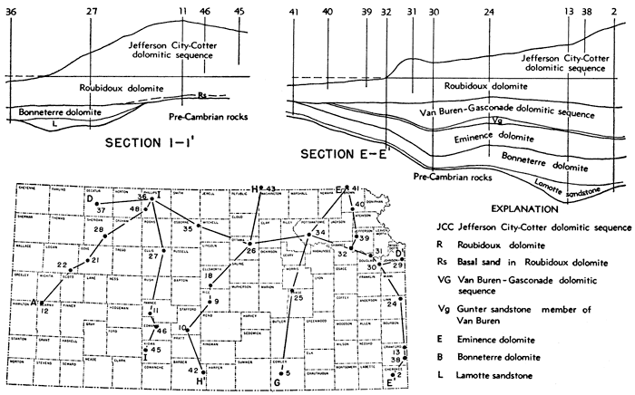
Figure 12--Diagrammatic cross sections on lines E-E' and I-I' and index of sections.
Cross Section on Line D-D' (Fig. 13)
Section D-D' extends westward from Johnson County near the Kansas-Missouri boundary to Decatur County in northwestern Kansas, passing through Douglas, Shawnee, Pottawatomie, Ottawa, Osborne, and Phillips counties. The total distance covered is 332 miles. The airline distance between the two ends of the section is 314 miles.
Figure 13--Diagrammatic cross sections on lines D-D', E-G, H-H' and I-A.
Beds ranging in age from Lamotte to Roubidoux are found in contact with the Pre-Cambrian surface in section D-D'. Lamotte sandstone immediately overlies the Pre-Cambrian rocks in wells in Johnson, Douglas, and Shawnee counties (wells 29 to 32). The variation in thickness of the Lamotte sandstone is presumably the result of irregularities on the surface of the Pre-Cambrian rocks upon which it was deposited. In Ottawa County Pre-Cambrian quartzite is overlain by Roubidoux dolomite (well 26). The Osborne County well (well 35) did not reach the Pre-Cambrian rocks. Westward, in Phillips County (well 36), Lamotte sandstone is absent and Bonneterre dolomite rests on the Pre-Cambrian rocks. Lamotte sandstone overlain by Bonneterre dolomite is present in Decatur County (well 37).
The Van Buren-Gasconade sequence, with the well-developed Gunter sandstone member of the Van Buren at the base, overlies a thick Eminence dolomite in Johnson and Douglas counties (wells 29 to 31). A green shale residue between the sand zone of the Bonneterre dolomite and the Gunter in a Shawnee County well (well 32) may represent either Eminence dolomite or the upper part of the Bonneterre dolomite. Eminence dolomite and the Van Buren-Gasconade sequence are absent from wells west of the Shawnee County well (well 32).
In section D-D' the Roubidoux dolomite rests on Gasconade dolomite, Bonneterre dolomite, and Pre-Cambrian rocks. It overlies the Van Buren-Gasconade sequence in Johnson, Douglas, and Shawnee counties (wells 29 to 32). The Roubidoux dolomite is in contact with the Bonneterre dolomite in western Kansas in wells in Phillips and Decatur counties (wells 36 and 37). In Ottawa County the Roubidoux dolomite immediately overlies Pre-Cambrian quartzite (well 26). The Bonneterre between wells 26 and 34 is inferred from the distribution map of the Bonneterre dolomite.
Post-Cotter erosion has resulted in the removal of the Cotter dolomite and probably the upper part of the Jefferson City dolomite from all the wells. A detrital zone above the Roubidoux dolomite in Johnson County (well 30) may represent a pre-St. Peter river channel, where more beds of the Jefferson City and Cotter were removed than in near-by wells. All these beds and considerable amounts of the upper part of the Roubidoux dolomite are absent from wells in Shawnee, Ottawa, Phillips, and Decatur counties. All the Upper Cambrian and Lower Ordovician strata that may have been deposited in the area of the Pottawatomie County well (well 34) were removed with the exception of 25 feet of Bonneterre dolomite and Lamotte sandstone.
Cross Section on Line E-E' (Fig. 12 and Pl. 6)
Section E-E' extends from Cherokee County, Kansas, to Richardson County, Nebraska, passing through Crawford, Linn, Douglas, Shawnee, Jefferson, and Brown counties, Kansas. The total distance covered is 220 miles. The airline distance between the two ends of the section is 200 miles.
The Bonneterre dolomite thins regularly from 187 feet in Cherokee County (well 2) to 79 feet in Richardson County (well 41). The Eminence dolomite increases in thickness from 122 feet in Cherokee County to 172 feet in Crawford County (well 13). It remains fairly constant in thickness in Linn and Douglas counties (wells 24 and 30) but thins to 80 feet in Shawnee County (well 32) and is absent in the Nebraska well (well 41).
The Van Buren-Gasconade dolomitic sequence is present as far north as Shawnee County (well 32). It has not yet been determined whether the thin section in this well represents the upper part of the formation, in which case the sand at the base is younger than Gunter sand elsewhere, or whether the upper beds were removed by pre-Roubidoux erosion. Beds of both the Eminence and Gasconade dolomites are absent from the Nebraska well, in which the Roubidoux dolomite rests on Bonneterre dolomite.
Section E-E' admirably illustrates the southward tilting of the Upper Cambrian and Lower Ordovician beds and removal by erosion after Cotter time of progressively greater thicknesses of Cotter and Jefferson City strata in a northward direction. In northern Kansas and southern Nebraska an undetermined thickness of upper beds of the Roubidoux dolomite also has been removed.
Cross Section on Line E-G (Fig. 13 and Pl. 6)
Section E-G extends from Cowley County, Kansas, to Richardson County, Nebraska, passing through Chase and Pottawatomie counties, Kansas. Both the total distance covered and the airline distance between the two ends of the section are approximately 210 miles.
The pre-Roubidoux high area in central Kansas is indicated. by the absence of beds older than Roubidoux in the Chase County well (well 25). To the north, in Pottawatomie County (well 34), the Roubidoux dolomite overlies Bonneterre dolomite, which has a thin bed of Lamotte sandstone at the base.
In Cowley County (well 5), post-Arbuckle erosion removed an undetermined thickness of Cotter and younger rocks. In Chase County (well 25) probably all the Cotter deposits and some of the upper beds of the Jefferson City are gone. The upper part of the Roubidoux dolomite was eroded in Richardson County, Nebraska (well 41).
Cross Section on Line H-H' (Fig. 13 and Pl. 6)
Section H-H' extends from Barber County, Kansas, to Jefferson County, Nebraska, passing through Stafford, Rice, Ellsworth, and Ottawa counties, Kansas. The total distance covered is 216 miles. The airline distance between the two ends of the section is 200 miles.
No formations older than Cotter or Jefferson City were penetrated by the well in Barber County (well 42). The Stafford County well (well 10) and the Nebraska well (well 43) passed through Roubidoux dolomite into Bonneterre dolomite but did not reach the Pre-Cambrian. Roubidoux or a basal sandstone probably of Roubidoux age is the oldest formation in contact with Pre-Cambrian rocks in the remaining wells in the section in Rice, Ellsworth, and Ottawa counties (wells 9, 18, and 26). These wells are on the crest of the centrally located pre-Roubidoux high area.
The northward thinning of the Cotter-Jefferson City sequence as indicated in section H-H' is the result of post-Arbuckle tilting and erosion.
Cross Section on Line I-I' (Fig. 12 and Pl. 6)
Section I-I' extends from Clark County to Phillips County, Kansas, passing northward through Kiowa, Edwards, Pawnee, Ellis, and Rooks counties. The total distance covered is 187 miles.
The wells in the extreme southern part of the cross section (wells 45 and 46) penetrate beds older than Cotter or Jefferson City. In Pawnee County (well 11) the Pre-Cambrian rocks are overlain by a basal sandstone of probable Roubidoux age. To the north, in Ellis and Rooks counties (wells 27 and 47), considerable thicknesses of Lamotte sandstone overlain by Bonneterre dolomite rest on the granite. In Phillips County (well 36), Lamotte sandstone is absent and Bonneterre dolomite overlies the Pre-Cambrian rocks.
The Roubidoux formation thickens northward from 137 feet in Pawnee County (well 11) to more than 200 feet in Rooks County (well 47).
Post-Arbuckle tilting and erosion have resulted in the removal of progressively greater thicknesses of Cotter and Jefferson City dolomites and younger beds from the area represented by the northern end of the section. In Rooks and Phillips counties (wells 47 and 36) the upper part of the Roubidoux dolomite was also eroded.
Cross Section on Line I-A (Fig. 13 and Pl. 6)
Section I-A extends from Kearny County to Phillips County, Kansas, passing northward through Logan, Gove, and Sheridan counties. Both the total distance covered and the airline distance between the two ends of the section are 160 miles.
The basin between the pre-Roubidoux high area in western Kansas and the pre-Roubidoux high area in central Kansas is crossed by this section. The Roubidoux dolomite found in the Kearny County well (well 12) which is located on the crest of the pre-Roubidoux high in western Kansas, overlies a thin section of Bonneterre dolomite beneath which the Lamotte sandstone is missing. The Eminence dolomite also is absent from this well. Similar relations are found in the wells in Rooks and Phillips counties (wells 36, 47, and 48) located on the border of the pre-Roubidoux structurally high area of central Kansas. In the basin between these two "highs" the Eminence dolomite is well developed, as shown by wells in southeastern Logan and Gove counties (wells 21 and 22), where it overlies a thickened section of Bonneterre dolomite. Lamotte sandstone is present at the base of the Logan County well (well 22).
Presumably the original thickness of Cotter and Jefferson City and younger strata in this area was nearly as great as in areas to the south and east. The thinning or absence of these formations in this section is due to post-Arbuckle erosion.
Prev Page--Subdivisions || Next Page--Summary
Kansas Geological Survey, Geology
Placed on web Jan. 22, 2010; originally published June 1948.
Comments to webadmin@kgs.ku.edu
The URL for this page is http://www.kgs.ku.edu/Publications/Bulletins/72/05_sect.html