![]()
Prev Page--Introduction || Next Page--Physiography
Stratigraphy
The Kiowa shale and Dakota formation of north-central Kansas constitute the lowermost Cretaceous of that area. In south-central Kansas (Barber, Kiowa, and Comanche counties) they are underlain by the Cheyenne sandstone (Latta, 1946). These Cretaceous formations lie unconformably on rocks of Permian age, and at the base in many localities there occurs a zone of water-worn pebbles imbedded in sand, silt, and clay. In the northernmost part of the State the Kiowa shale is absent, and the Dakota rests directly on Permian rocks. The Dakota is conformably overlain by, and transitional with, marine Graneros shale. The literature concerning the stratigraphy of the Dakota and Kiowa formations in Kansas has been reviewed in detail by Tester (1931, pp. 204-230), and more recently Plummer and Romary (1942) have classified the Dakota beds in stratigraphic units that they have correlated throughout central Kansas.
The Regional Dakota-Kiowa Contact
All geologists who have worked in the area in the past few years agree that the contact of the Dakota formation and Kiowa shale is conformable and interfingering, so that at any one locality the two formations may be interbedded, with typical marine Kiowa strata overlying the littoral or continental deposits of the Dakota. Latta (1946, p. 250) chose as an arbitrary line to mark the Kiowa-Dakota boundary the top of the uppermost marine stratum of the particular section being studied, and Frye and Brazil (1943) and Swineford and Williams (1945) chose the base of the lowermost nonmarine bed to mark the same formational boundary. In the present paper Dakota and Kiowa are used in a strictly lithologic sense, taking account of the interfingering of the two lithologies. Thus, sandstones in this part of the section that are characterized by marine fossils or thick deposits of dark-gray pyritic shale with selenite and cone-in-cone are classed as Kiowa, and sandstones associated with light-firing red and gray clays, leaf impressions, and siderite "shot" are classed as Dakota, even though locally rocks called Kiowa may overlie rocks called Dakota.
Dakota Formation
The resistant, most conspicuous beds of the Dakota are the dark-brown sandstones cemented with iron oxide which cap the hills and produce the irregular topography so common in the Dakota outcrop area. These lenticular sandstones, as shown by Plummer and Romary (1942), have no stratigraphic significance and may be found at any horizon within the formation. Iron oxide is the typical and predominant cement in the outcropping sandstones of the Dakota.
Carbonate-cemented sandstone in the Dakota formation occurs as concretionary bodies in beds of loose sand or iron oxide-cemented sandstone. It has been found by Plummer (personal communication) to occur at three or more horizons within the formation: (1) at the base, (2) near the middle of the Terra Cotta clay member, and (3) at or near the top of the Terra Cotta clay. This sandstone or "quartzite" has been discussed at length by Plummer and Romary (1942, pp. 325, 329, 332, 333, 336, 340) from whose report the following discussion has been adapted. [Note: Plummer and Romary use the term quartzite within quotation marks for convenience, as it is the local designation of this carbonate-cemented sandstone.]
In the generalized section of the Dakota formation in north-central Kansas Plummer and Romary (1942) describe 17 stratigraphic units designated as beds, and the carbonate-cemented sandstone occurs in beds 1, 6, and 9. They describe bed 1 (basal Dakota formation) as siltstone and fine sandstone, mostly thin-bedded, but locally cross-bedded. This zone characteristically contains "quartzite" concretions, but where the sandstone is not quartzitic, it is commonly very friable. Fossil leaves, fragments of lignite, and nodules are common. Bed 1, which has a maximum thickness of 20 feet, is absent in some places, in which case Dakota clay (bed 2) rests directly on Kiowa shale or older rocks. The base of the Dakota is placed arbitrarily by Plummer and Romary at the base of the "quartzite"-bearing siltstone or sandstone described as bed 1. They state that the contact cannot be identified postively unless the dark fissile shale of the Kiowa can be found below the "quartzitic" bed 1, inasmuch as a series of beds resembling those from 1 to 5 occurs somewhat higher in the Terra Cotta member.
Bed 6 is described as follows: Clay, mottled gray and red, massive, of the fire-clay type, obliquely jointed irregularly, and breaking out with a conchoidal fracture. This bed contains economically important zones of gray fire clay having a high alumina and low iron content. Some seemingly persistent zones of concretionary iron in the form of limonite, siderite, or hematite pellets, or of granular hematite, occur in this bed. There are also some thin zones of sandstone and silt, not channels or bars, in which "quartzite" concretions are commonly found. The thickness of bed 6 ranges from 100 to 150 feet.
Bed 9, the top of which is 10 feet or less below the base of the Janssen clay member, consists of silt and sandstone, very fine, gray or yellow, generally thin-bedded and containing lignite particles. In many places this bed is "quartzitic," or contains ellipsoidal concretions of "quartzite." Where present, it is as much as 10 feet thick. The contact between the Terra Cotta and Janssen members is drawn at the top of a bed containing a marked concentration of concretionary "iron." In many places the "quartzitic" silt or fine sand underlies the concretionary "iron" bed. Plummer and Romary thought that the presence of the "quartzite" is due to the fact that the conditions favorable to cementation are distributed at definite horizons and that a "quartzite" is formed wherever there is a bed of sufficient permeability.
A fourth horizon, not specifically referred to in the report by Plummer and Romary, was observed to contain carbonate-cemented sandstone. It is at or near the top of the Janssen member (uppermost Dakota) and contains such sandstone in at least two localities. (1) In western LincoIn County, near Sylvan Grove (sec. 7, T. 12 S., R. 10 W.) it contains a large lenticular mass, one-half mile in diameter, which is being quarried by the Quartzite Stone Company of Lincoln, Kansas. (2) In a small area in eastern Jewell County (SW sec. 12, T. 5 S., R. 6 W.) outcrops were studied along the bluff which forms the south wall of Buffalo Creek Valley. This locality was brought to my attention by A. R. Leonard, who measured the section and found this rock to be at or very near the top of the Dakota formation (personal communication).
In the Jewell County locality the cemented sandstone is less than 3 feet thick, and the upper surface of some of it is a fairly coarse, shark-tooth conglomerate. Several types of teeth are present, among which seem to be Corax curvatus Williston and at least two species of Ptychodus. Williston (1900, p. 242) described a similar conglomerate in Ellsworth County as follows:
Three small teeth . . . from the conglomerate containing specimens of Corax curvatus, appear to belong to this species Ptychodus janewayii. The horizon of the conglomerate is near the line of contact between the Dakota and Benton, in Ellsworth County. Cope's type was from a bed of Conglomerate containing Lamna and Isurus teeth of smill size near Stockton. it is probable that the horizon is the same in both.
Cretaceous rocks which crop out in the vicinity of Stockton are Niobrara chalk and upper Carlile shale, so that the two exposures of conglomerate described by Williston cannot be considered correlatives. The presence of the conglomerate in Jewell County, however, may provide a clue to the environmental conditions of deposition of the sandstone. If it is a marine conglomerate, it should probably be referred to the base of the Graneros shale.
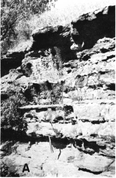
Silica is the cementing material in a sandstone of the upper bed of the Janssen clay member of the Dakota formation, exposed for three-fourths mile on the south side of the Arkansas River southwest of the town of Hartland in Kearny County (sec. 17, T. 25 S., R. 37 W.). The sandstone, or quartzite, of this area is 3 to 5 feet thick (Pl. 1C) and in a few places contains the vertical holes or channels resembling worm borings or root and stem molds which are reported by Plummer and Romary (1942, p. 339) to be characteristic of the same unit in north-central Kansas. McLaughlin (1942, pp. 77-79) reports massive ledges of sandstone cemented by pale-gray quartz in the Dakota formation (Cockrum sandstone) of Morton County, but he does not give their stratigraphic position. Iron oxide is the only other cementing material referred to by him in the Dakota of that county.
Plate 1--A, Dolomite-cemented sandstone in the Sylvan Grove quarry, sec. 7, T. 12 S., R. 10 W., Lincoln County. B, Twin Mounds, capped with silica-cemented sandstone: NW sec. 1, T. 18 S., R. 2 W., McPherson County. C, Quartzite in yellow-brown sandstone at top of Dakota formation, sec. 17, T. 25 S., R. 37 W., Kearny County. Note lenticular nature of the quartzite.
Calcite-cemented glauconitic sandstone occurs in the subsurface Dakota of southwestern Russell County in a zone about 50 feet above the base of the formation (Swineford and Williams, 1945, pp. 116-117), but it was not noted in the Kiowa shale of this area. This zone is thought to be contained in bed 6 of the generalized section by Plummer and Romary (1942, p. 329), but it may represent a late readvance of the Kiowa sea.
The upper siltstone of the Dakota forms a resistant ledge in Hodgeman and Ford counties (Pl. 2B) and other areas. This bed was observed to be white or light gray to yellowish brown in color, noncaleareous, and softer than quartzite. It is thought to be a clayey siltstone impregnated with finely divided silica.
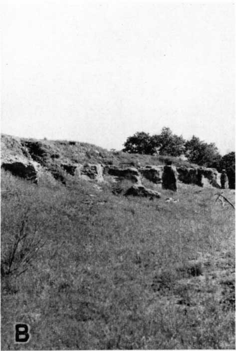
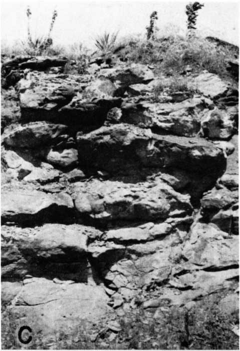
Plate 2--A, lnterbedded ferruginous sandstone and calcite-cemented sandstone in cut-bank of small stream in SW SW sec. 28, T. 18 S., R. 7 W., Rice County. Hammer hangs on lowermost calcareous lentil; above it are five other protruding ledges of calcareous sandstone. Topmost massive bed is case-hardened ferruginous sandstone. B, Natural exposure of upper siltstone member of the Dakota formation, SE sec. 12, T. 25 S., R. 24 W., Ford County. The matrix consists of siliceous clay. C, Small quarry in calcite-cemented sandstone, NW sec. 14, T. 18 S., R. 2 W., McPherson County.
Calcite- and silica-cemented sandstones in deposits of the Dakota Stage in Iowa and Nebraska
Tester's (1931) report on the Dakota Stage of the type locality contains many references to calcite-cemented sandstones, and the descriptions and illustrations of these rocks, which occur both in the Dakota formation and the Graneros shale, indicate their similarity to those in Kansas. Tester (1931, pp. 237, 241, 245, 249, 250) describes calcite-cemented sandstones in the Dakota of the following localities. (1) Pits of the Sioux City Brick Company at Riverside, west part of Sioux City, Iowa, along the South Dakota branch of the Chicago, Milwaukee, St. Paul & Pacific Railroad; E. side sec. 23, T. 89 N., R. 48 W., Woodbury County, Iowa; sandstone at the top of the Dakota and at one lower horizon. (2) Sec. 11, T. 89 N., R. 48 W., Woodbury County, Iowa, west of Sioux City in the bluff facing Big Sioux River at old quarry site south of west entrance to Stone Park; sandstone about 45 feet below top of Dakota. (3) At Sergeant Bluff, sec. 30, T. 88 N., R. 47 W., Woodbury County, Iowa; in pits of Ballou Brick Company; sandstone at three horizons. (4) In the bluff 2 1/2 miles southeast of Homer, sec. 20, T. 27 N., R. 9 E., Dakota County, Nebraska; calcite-cemented sandstone in one small exposure. (5) SW sec. 23, T. 27 N., R. 8 E., and NE sec. 26, T. 27 N., R. 8 E. about 2 miles south of Homer, Dakota County, Nebraska; sandstone at one horizon. At all except one of these localities the sandstone contains either glauconite or marine fossils or both, which Tester interprets as indicating a marine invasion. They may mark one or more early invasions of the Graneros sea.
Gould (1900, p. 430) describes one locality of quartzite in the Dakota of Nebraska. This occurs about 5 miles northwest of Fairbury, near Whiskey Run, as a ledge about 3 feet thick. Gould does not describe its stratigraphic position but writes,
It differs from anything seen elsewhere in the State except somewhat similar ledges found near the old mission on the Omaha Reservation and along the bluffs to the north, although quartzite boulders similar in character are found in Saline and McPherson counties, Kansas.
Whiskey Run is a short, southward-flowing tributary to the Little Blue River. I was unable to find any Cretaceous quartzite in the area, but a small ledge of dense, gray, calcite-cemented sandstone at or near the top of the Dakota formation occurs near the stream in sec. 33, T. 3 N., R. 2 E.
Kiowa Shale
The Kiowa shale consists of dark-gray to black shale with thin beds and lenses of fine-grained sandstone and thin beds of fossiliferous limestone. Pyrite, gypsum, and cone-in-cone are abundant in the formation. The sandstones are more persistent than are those of the Dakota, but they cannot be traced over long distances. Carbonate-cemented sandstone occurs at several horizons in the Kiowa, and silica-cemented sandstone has been observed in the formation at isolated localities in McPherson and Rice counties (Williams and Lohman, in press). Iron oxide-cemented sandstone is common in the "Black Hills" of southwestern Dickinson County. This is believed to be in the Kiowa shale, but some of it may occur in the Terra Cotta clay member of the Dakota formation. A small quantity of carbonate-cemented sandstone also occurs in this area.
In Rice County, O.S. Fent (personal communication) noted that sandstone with carbonate cement occurs in at least three zones within the Kiowa shale. He also observed cone-in-cone in the shale at the same horizon at other localities where the sandstone is absent. In the basal part of some of the exposures of calcite-cemented sandstone he noted numerous fragments of shells.
In McPherson County, carbonate-cemented sandstone associated with cone-in-cone caps a 4-mile north-south discontinuous ridge in the northeastern part of T. 18 S., R. 2 W. Other small areas of carbonate-cemented sandstone occur in northeastern McPherson County. Near Battle Hill school, 5 miles south of Roxbury, sandstone with silica cement cropped out in four low hills. This sandstone, most of which has been removed for road material, occurred not far above Permian rocks of the Sumner group. Twenhofel (1924, p. 40) writes, "The sandstones of the 'Dakota' [sic] form a compact quartzitelike rock on the hills south of Roxbury"; but elsewhere in the same report (p. 12, pl. 1) he maps these rocks as marine strata and by implication calls them Comanchean. In the usage of this paper it would probably be classed as Kiowa formation. It is referred to the Kiowa shale by Williams and Lohman (in press). Silica-cemented sandstone tentatively classed a Kiowa is observed capping Twin Mounds (Pl. 1B), about 5 miles southwest of Roxbury. A thin lens of silica-cemented reddish-brown sandstone also occurs a few feet above some carbonate-cemented sandstone 3 miles west of Roxbury (NE sec. 25, T. 17 S., R. 2 W.).
Calcite-cemented sandstone in the Kanopolis quarry, sec. 19, T. 16 S., R. 6 W., Ellsworth County, is thought to occur in the Kiowa shale because it overlies black shale containing gypsum and pyrite and because it is associated with cone-in-cone. The cone-in-cone at this locality curves around the lower sides of concretionary bodies of cemented sandstone and above more of the same sandstone. Cone-in-cone has not been described from the Dakota formation of Kansas, although it is reported by Tester (1931, p. 261) from a few feet below the base of the Graneros shale in one locality in Nebraska. Liesegang banding is well developed on the upper weathered surface of some of the sandstone in this quarry.
Carbonate- and silica-cemented sandstone in sec. 33, T. 15 S., R. 7 W., about 2.5 miles east of Kanopolis, on the east side of the Smoky Hill River, is described by Twenhofel and Tester (1926, p. 558) as follows.
Sandstone, gray, fine to medium grained; usually in massive beds, making principal ledge of bluff; variously cross-bedded. The member is essentially calcareous, though considerable silicification has occurred in the upper part. In many respects this sandstone resembles some phases of the Mentor of the Salina region, and is considered to be the equivalent of the Mentor.
The bed is reported by them to be 6 to 7 feet thick.
In Saline County calcite-cemented sandstone is well exposed in the Camp Phillips quarry (NW sec. 36, T. 14 S., R. 4 W.). Its stratigraphic position is near the base of the Dakota formation; it contains barite sand-crystals, which have not been noted in unquestioned Dakota, and cone-in-cone. It therefore is tentatively placed in the upper part of the Kiowa shale.
Prev Page--Introduction || Next Page--Physiography
Kansas Geological Survey, Geology
Placed on web June 14, 2007; originally published Nov. 1947.
Comments to webadmin@kgs.ku.edu
The URL for this page is http://www.kgs.ku.edu/Publications/Bulletins/70_4/03_strat.html